Report on Turrialba (Costa Rica) — February 2010

Bulletin of the Global Volcanism Network, vol. 35, no. 2 (February 2010)
Managing Editor: Richard Wunderman.
Turrialba (Costa Rica) Phreatic eruption of 5-6 January 2010 opens SW crater's upper wall
Please cite this report as:
Global Volcanism Program, 2010. Report on Turrialba (Costa Rica) (Wunderman, R., ed.). Bulletin of the Global Volcanism Network, 35:2. Smithsonian Institution. https://doi.org/10.5479/si.GVP.BGVN201002-345070
Turrialba
Costa Rica
10.025°N, 83.767°W; summit elev. 3340 m
All times are local (unless otherwise noted)
Since 2002, elongate cracks have opened at Turrialba, and new points began degassing, emitting high levels of sulfurous gas and helium, but no eruptions had occurred (BGVN 32:08, 33:01, and 34:09). Ongoing fumarolic activity through August 2009 caused significant damage to local vegetation (BGVN 34:09). This report continues through February 2010. Phreatic eruptions on 5 and 6 January 2010 resulted in ashfall ten's of kilometers from the active W crater. New vents formed on the crater wall, ultimately merging into an elongate fissure.
On 25 September 2009, scientists from the Observatorio Vulcanológico y Sismológico de Costa Rica, Universidad Nacional (OVSICORI-UNA) reported results from three trips to inspect new fissures and to assess the impact of gases. Gases blown 10 km SW mildly burned trees to a greater degree than the previous year. Vegetation within a 4-km radius on the W, NW, and E flanks was also burned more severely that previously noted. Several elongated fissures were documented on the rim S of the W crater, as well as 1 km downslope to the NW. One E-W-trending crack that was first seen several months before had opened as much as 12 cm, and emitted gas and vapor at 90°C. On the lower NW flanks, at least three radial fissures emitted high gas-and-steam plumes. Some fissures near the summit were 5-10 cm wide. The last of the remaining residents in the affected areas had moved away due to the intensification and impact of the gases.
Report from the Red Sismológica Nacional, January 2010. Gerardo J. Soto sent a report by the Red Sismológica Nacional (National Seismological Network; RSN: UCR-ICE) summarizing events during early January. The seismic signals recorded during 2009 consisted mostly of B-type earthquakes, tremor, and some A-type earthquakes. The seismic records through the afternoon of 3 January remained typical, but after 1000 on 4 January signals underwent a sudden change. Tremor became common and was of long duration (~ 4 events/hour with typical durations of 10-20 minutes), but signals did not suggesting internal fracturing. Abundant low-frequency signals (B-type earthquakes) corresponded with substantial gas plumes. After 1400 on 5 January tremor occurred almost constantly. Two strong earthquakes occurred, at 1429 and 1445.
These two earthquakes coincided with the first reports of ash, which fell mainly over the farms adjacent to La Central and La Silvia, Capellades town. Finer ash was reported at Tierra Blanca, Llano Grande and Tres Ríos, ~ 25 km SW, and in eastern San José, ~ 30 km away. The ash was expelled for over 22 hours, in a continuing sequence of pulses.
The RSN report further stated that field and aerial trips inspected the two small pits that opened on the upper SE wall of the SW crater. These pits later joined and formed a fracture-like structure (aligned N40°E, the same trend as the tectonic depression and faults on the summit). The ash emitted from the pits was devoid of new (juvenile) magma material and most clasts were hydrothermally altered. Fumaroles expelled gas and ash at high pressure with a jet-type noise heard several kilometers away. Observers approaching the pits on the 6th watched pulsating emissions coming from both new vents on the upper wall.
Report from OVSICORI-UNA, January-February 2010. An OVSICORI-UNA report written on 6 January also noted that the phreatic eruption began at 1400 on 5 January, followed by reports of ashfall as far away as 30 km, particularly in areas to the SW. Residents of the village La Central located ~ 4 km SW of the crater heard nothing but received fine ash (figure 19) accompanied by rain. In contrast, in the village of La Silvia located roughly the same distance W of the crater, people heard noises attributed to eruptions. Erupted material was generally fine-grained (sub-millimeter in diameter) and dark.
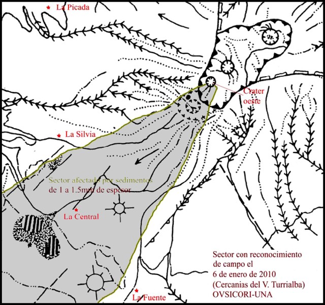 |
Figure 19. Sketch map of Turrialba emphasizing the fresh deposits mapped on 6 January 2010 (shaded area). The town of La Central (~ 4 km from the W crater) lies on the approximate dispersal axis and received 1-1.5 mm of ash fall. Courtesy of OVSICORI-UNA. |
Mapping by OVSICORI-UNA on 6 January traced the deposit WSW (figure 21); the deposit had a thickness of 1-1.5 mm between La Central and La Silvia. At 8 km from the vent on the road near Oreamuno the deposit was ~ 0.5 mm thick. Some fine ashfall was seen 15 km from the vent (at Llanos Grande) and reached ~ 30 km away to neighborhoods of SE San Jose. The delicacy of the deposit and the associated rain meant that some of the best samples came from roof tops and plant leaves. On corrugated roofs the uppermost portions of the ridges still preserved considerable ash. Some of the near-source ejecta were on the order of a meter in diameter.
Field observations on 6 January revealed that two small vents had opened and joined together on the SE inner wall of the SW crater. Gas emission temperatures were more than 350°C. On 8 January seismic activity and gas emissions decreased. Observations on 9 January revealed that the combined vent was about 20-25 m wide and 65-80 m long (figures 20 and 21).
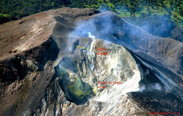 |
Figure 20. An aerial view on 9 January 2010 of Turrialba's W crater and one or more new cavities developed in the upslope area (see enlarged view in next figure). Courtesy OVSICORI-UNA. |
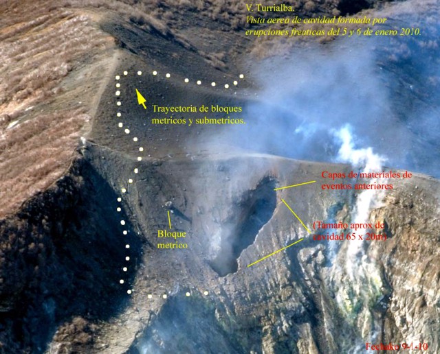 |
Figure 21. Close-up of the area affected by Turrialba's phreatic eruption as seen from the air on 9 January 2010. The vent on the far wall began as two small separate ones. The cover of fresh fine-grained deposits appears as a smooth area around the new vent. Some of the larger near source ejecta reached on the order of a meter or so across. Courtesy OVSICORI-UNA. |
A plume on 15 February that reached 1.5-2 km in height was photographed by OVSICORI-UNA (figure 22). The noise from the emission was heard 4 km to the SW.
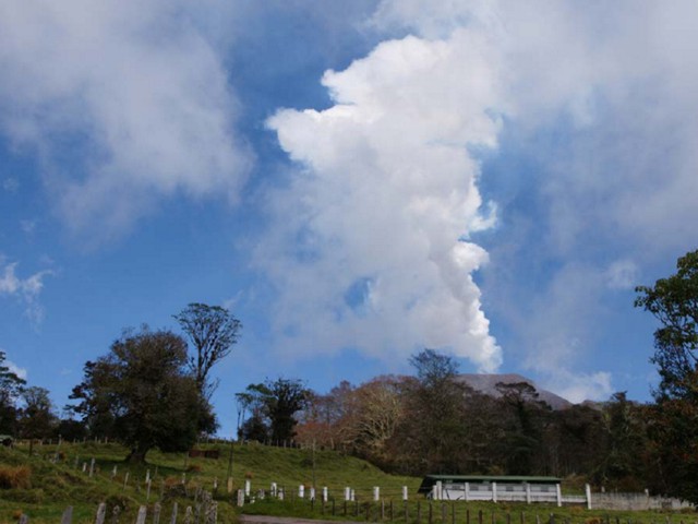 |
Figure 22. Photograph of a weak, inclined steam-and-gas plume from Turrialba taken on 15 February 2010. Courtesy OVSICORI-UNA. |
Aviation notices, January 2010. Washington Volcanic Ash Advisory Center (VAAC) reports started on 7 January, and began with pilot reports of ash to the E of the summit, but analysts lacked clear evidence of ash based on satellite imagery. METAR reports (routine, in most cases hourly, aviation weather reports from places such as airports) continued to mention the plume on the 7th, but weather clouds prevented detection of possible ash clouds. Later on the 7th, analysts began to rely on a wider array of data, and although still unable to see the plume in imagery, they began to put out numerous regular reports through the 9th. On 16 January the VAAC reported that the "Observatory has confirmed that there are no ash emissions at this time. Gas and steam emissions are possible."
Geological Summary. Turrialba, the easternmost of Costa Rica's Holocene volcanoes, is a large vegetated basaltic-to-dacitic stratovolcano located across a broad saddle NE of Irazú volcano overlooking the city of Cartago. The massive edifice covers an area of 500 km2. Three well-defined craters occur at the upper SW end of a broad 800 x 2200 m summit depression that is breached to the NE. Most activity originated from the summit vent complex, but two pyroclastic cones are located on the SW flank. Five major explosive eruptions have occurred during the past 3500 years. A series of explosive eruptions during the 19th century were sometimes accompanied by pyroclastic flows. Fumarolic activity continues at the central and SW summit craters.
Information Contacts: E. Duarte, E. Fernández, J. Brenes, R. Van der Laat, and T. Marino, Observatorio Vulcanologico Sismologica de Costa Rica-Universidad Nacional (OVSICORI-UNA), Apartado 86-3000, Heredia, Costa Rica (URL: http://www.ovsicori.una.ac.cr/); Gerardo J. Soto, Red Sismológica Nacional, Escuela Centroamericana de Geología (UCR). Apdo. Postal 214-2060, San José, Costa Rica (URL: http://rsn.ucr.ac.cr/); Washington Volcanic Ash Advisory Center, Satellite Analysis Branch (SAB), NOAA/NESDIS E/SP23, NOAA Science Center Room 401, 5200 Auth Rd, Camp Springs, MD 20746, USA (URL: http://www.ospo.noaa.gov/Products/atmosphere/vaac/).