Report on San Cristobal (Nicaragua) — April 2010

Bulletin of the Global Volcanism Network, vol. 35, no. 4 (April 2010)
Managing Editor: Edward Venzke.
San Cristobal (Nicaragua) Intermittent ash plumes and gas emissions during April 2006-June 2009
Please cite this report as:
Global Volcanism Program, 2010. Report on San Cristobal (Nicaragua) (Venzke, E., ed.). Bulletin of the Global Volcanism Network, 35:4. Smithsonian Institution. https://doi.org/10.5479/si.GVP.BGVN201004-344020
San Cristobal
Nicaragua
12.702°N, 87.004°W; summit elev. 1745 m
All times are local (unless otherwise noted)
Activity at San Cristóbal reported by the Instituto Nicarag?ense de Estudios Territoriales (INETER) included ash explosions in December 2004 and November 2005 (BGVN 31:09). Activity continued in 2006, with frequent gas explosions, some with minor amounts of ash during January (80 explosions) and February (47 explosions). Ash explosions were noted in news reports on 6 March 2006, and additional phreatic explosions caused ashfall on 23 April (BGVN 31:09). Fieldwork by INETER staff, typically Vicente Perez, was usually done once per month to make crater observations and take fumarole temperatures. Tremor recorded from 2006 through 2009 was variable, corresponding largely to changes in gas output.
Activity during late April-December 2006. Seismicity remained high through 27 April, and an ash plume was photographed on the 25th (figure 13). Seismicity declined, but increased again during another episode of phreatic explosions that began on 18 May and continued until 27 May 2006. Observations at the summit crater during June-September 2006 revealed very little change, but rockfalls were heard. During fieldwork on 12 November there was abundant gas in the crater, and fumarole temperatures were unchanged.
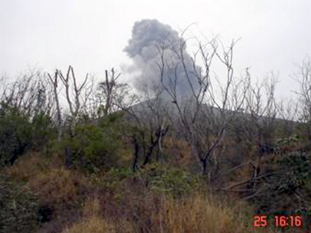 |
Figure 13. Ash plume rising from San Cristóbal on the afternoon of 25 April 2006. Courtesy of INETER. |
Activity during 2007. Rockfall noises from landslides within the crater were heard on 12 January and 6 February 2007. Landslides from the E crater wall continued on 6 March. Crater visits on 21 May and 10 June were hampered by gas emissions, especially SO2 fumes. Water levels in the crater lakes, located in the western and southern parts of the crater, were high on 22 July because of the rainy season, resulting in increased gas emissions.
On 11 August Perez observed the main crater where he noted ongoing abundant gas emissions, fan-like sounds inside the new crater, and landslides on the S crater wall. Activity on 15 September consisted of landslides on the S and W slopes, and a strong sulfur odor. Visitors to the summit on 10 November reported abundant gas and saw ash and blocks ejected during explosive activity days earlier (days were not specified). The size of the ejecta ranged from 20 x 40 cm up to 120 x 90 cm. Perez reported on 6 December that abundant gas emissions were continuing in the N part of the inner crater, accompanied by loud noises. Small landslides on the N flank were seen later in the month.
Activity during 2008. The abundant gas emission continued into January 2008 but declined in February and March. Gas emissions in April appeared heavier. On 30 April heavy gas emanation accompanied jet engine noises from within the crater. On 4 May there were continuing abundant gas emissions.
On 11 June loud sounds from the bottom of the crater occurred at intervals of 15-20 minutes accompanied by abundant degassing. On 22 June a moderate explosion generated a gas-and-ash plume. The Civil Defence Center in Managua reported minor ashfall in the city of Chinandega (~ 16 km SW) and in the communities of La Bolsa, Valle de los Morenos, and Cosmapa. Weeks before the explosion on 22 June, the number of volcano-tectonic earthquakes had slowly increased to 300 earthquakes per day (figure 14). The slightly elevated activity continued during July. A gas-rich cloud continued being expelled from the crater, accompanied by loud rumbling. On the night of July 10 an episode of seismic tremors lasted several hours. The next morning, 11 July, a series of explosions ejected gas and ash that was blown W. Local residents reported minor ashfall in the cities of El Viejo (~ 18 km WSW) Chinandega.
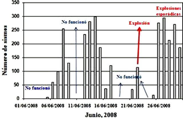 |
Figure 14. Daily number of seismic events at San Cristóbal during June 2008. The ash explosion on 22 June was preceded by elevated seismicity (recorded when the instrument was operational) and followed by both high seismicity and sporadic explosions. Courtesy of INETER. |
In early August several small explosions of ash and gas occurred. Abundant degassing continued throughout September and October. On 18 October some collapse of the crater walls was noted. Throughout that period, seismicity was high and steadily increasing from 90 earthquakes/day in August to 120 per day in September and October. During October, audible noises were heard from the crater and landslides again occurred along the crater walls.
On 6 November degassing and strong noises originated from the crater floor. Seismic tremor began to increase on 13 November; a seismic swarm took place 17-19 November with earthquakes (magnitudes 3.5-4.0) felt by residents in communities surrounding the volcano. Scans on 21 November through the volcanic plume yielded an average sulfur dioxide flux of 1,124.5 ? 212.5 metric tons /day (t/d). Small explosions that afternoon caused ashfall in Las Moras, La Bolsa, and Belén, located S of the volcano. When climbing to the crater on 10 December, Perez noted abundant ash and rocks of variable sizes expelled by the 21 November activity was deposited in the S and NE part of the crater. Abundant gas emissions from the crater continued.
Activity during 2009. January, February, and March were notable for their consistency in heavy gas emissions. In late March there were notable temperature increases at most of the vents. Eight measurements using a Mobile Mini DOAS over about 2 hours resulted in an average SO2 flux of 650 t/d. May, June, July and August were months of sustained abundant gas emission (figure 15) with very little other notable activity beyond occasional landslides, some of which obstructed gas vents. Average SO2 flux on 30 July was 1,249 t/d. Measurements made in May 2009 (274.7 t/d) were much lower. Based on analysis of satellite imagery, the Washington VAAC reported that on 19 May a diffuse plume drifted 45 km SW.
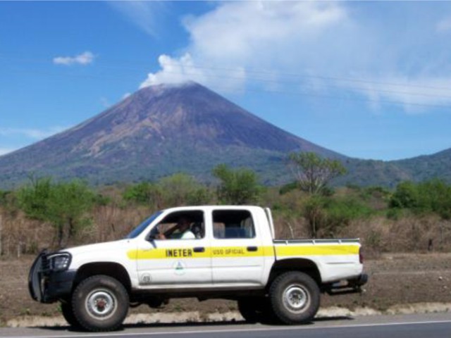 |
Figure 15. Small gas plume at the summit of San Cristóbal, May 2009. Courtesy of INETER. |
A seismic swarm on 4 September lasted about 30 minutes, and a strong explosion took place on 6 September (figure 16). An explosion on 6 September 2009 at 1350 created an ash column that reached an approximate height of 200 m; four explosions of lesser intensity followed. The Washington VAAC issued an advisory noting ash up to an altitude of 8.5 km that was drifting 75 km W. This activity continued until approximately 1440. The material ejected affected communities between the towns of Grecia and El Piloto, and along the road from Chinandega to the Guasaule border post. Perez, during a visit on 11 September, heard loud rumbling landslides into the crater and observed gas emissions. The number of daily seismic events increased on 11 September, then gradually declined throughout the month (figure 17).
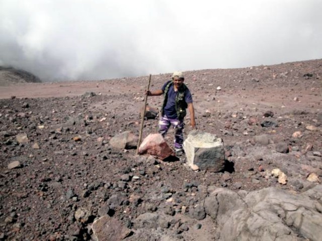 |
Figure 16. Rocks ejected by the 6 September 2009 explosion at San Cristóbal. Photo taken on 24 November; courtesy of INETER. |
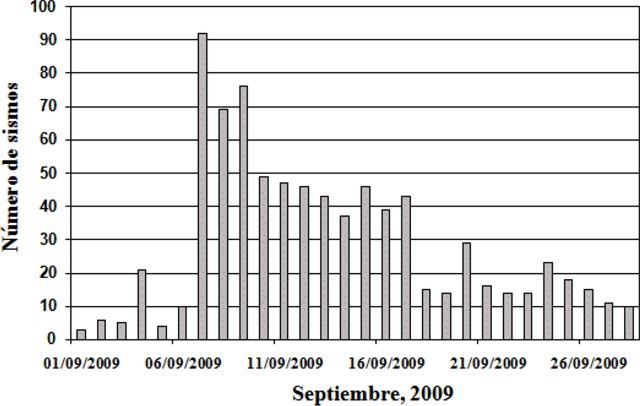 |
Figure 17. Number of daily seismic events at San Cristóbal, September 2009. Courtesy of INETER. |
On 14 September an explosion at approximately 1050 was recorded by the seismic station located on the SW flank. The column rose ~ 350 m, and ejected material fell on the Las Rojas farm and in the towns of Las Banderas and Mokoron. On 18 September the average SO2 gas-flux was 319 t/d, a significant decrease with respect to July. However, on 6 September, when about eight explosions occurred, the average SO2 flux was 1,657 t/d.
Abundant gas emissions from the NE part of the crater were see during 18 October fieldwork, though landslides had obstructed vents. On 22 October the measured SO2 flux had decreased further compared to September. Abundant emission of gases continued and the widening of the crater in the S was noted on 24 November; there were ash deposits on the solar panels of the S-flank seismic station. Landslides around the crater and gas emissions were continuing on 8 December.
Based on analyses of satellite imagery, the Washington VAAC reported that on 6 December a gas-and-steam plume, possibly containing ash, drifted SW; smoke from local fires was also noted. Based on METAR weather reports, the Washington VAAC again reported that a gas-and-steam plume possibly contained ash on 22 December. Satellite imagery from 26 December showed an ash plume drifting 90 km WSW.
Activity during January-June 2010. Gas emissions continued in 2010, with fieldwork observations on 7 January, 14 February, and 14 March. No activity was reported by Perez following a visit on 27 April. Based on analyses of satellite imagery, the Washington VAAC reported that on 9 June a well-defined ash plume drifted about 115 km WNW.
Geological Summary. The San Cristóbal volcanic complex, consisting of five principal volcanic edifices, forms the NW end of the Marrabios Range. The symmetrical 1745-m-high youngest cone, named San Cristóbal (also known as El Viejo), is Nicaragua's highest volcano and is capped by a 500 x 600 m wide crater. El Chonco, with several flank lava domes, is located 4 km W of San Cristóbal; it and the eroded Moyotepe volcano, 4 km NE of San Cristóbal, are of Pleistocene age. Volcán Casita, containing an elongated summit crater, lies immediately east of San Cristóbal and was the site of a catastrophic landslide and lahar in 1998. The Plio-Pleistocene La Pelona caldera is located at the eastern end of the complex. Historical eruptions from San Cristóbal, consisting of small-to-moderate explosive activity, have been reported since the 16th century. Some other 16th-century eruptions attributed to Casita volcano are uncertain and may pertain to other Marrabios Range volcanoes.
Information Contacts: Instituto Nicaraguense de Estudios Territoriales (INETER), Apartado Postal 2110, Managua, Nicaragua (URL: http://www.ineter.gob.ni/); Washington Volcanic Ash Advisory Center, Satellite Analysis Branch (SAB), NOAA/NESDIS E/SP23, NOAA Science Center Room 401, 5200 Auth Rd, Camp Springs, MD 20746, USA (URL: http://www.ospo.noaa.gov/Products/atmosphere/vaac/).