Report on Ubinas (Peru) — April 2010

Bulletin of the Global Volcanism Network, vol. 35, no. 4 (April 2010)
Managing Editor: Edward Venzke.
Research and preparation by Hugh Replogle.
Ubinas (Peru) Frequent ash plumes between July 2008 and August 2009
Please cite this report as:
Global Volcanism Program, 2010. Report on Ubinas (Peru) (Venzke, E., ed.). Bulletin of the Global Volcanism Network, 35:4. Smithsonian Institution. https://doi.org/10.5479/si.GVP.BGVN201004-354020
Ubinas
Peru
16.345°S, 70.8972°W; summit elev. 5608 m
All times are local (unless otherwise noted)
Eruptions at Ubinas between March 2006 and July 2008 caused ashfall in local villages and damaged crops (BGVN 31:03, 31:05, 31:10, 33:01, 33:06). Families from the village of San Pedro de Querapi had been relocated, however they returned to their fields to pursue their agricultural activities. Local authorities have discussed the possible relocation, over several years, of about 650 families from six towns (Escacha, Tonoaya, San Migues, San Pedro de Querapi, Huataga and Ubinas).
Persistent fumarolic plumes continued through 2008 (figure 15) along with intermittent ash explosions (figure 16). Pilot reports and satellite imagery resulted in frequent aviation warnings of ash plumes (table 5) during July-November 2008, January-March 2009, and May-August 2009. It is likely that additional explosion plumes were not observed; for example, a dark ash plume on 8 January 2008 (figure 16) was not previously reported. Most plumes rose a short distance above the summit, although a few went to about 10 km altitude (4.4 km above the summit), including one on 15 March 2009 (figure 17).
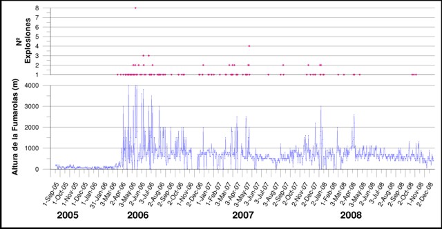 |
Figure 15. Volcanic activity at Ubinas, September 2005 through 2 December 2008. Courtesy of Instituto Geologico Minero y Metalurgico (INGEMMET) report of June 2009. |
Table 5. Compilation of Volcanic Ash Advisories for aviation from Ubinas during 23 July 2008 through 23 August 2009. All reported plumes were reported as ash-bearing unless otherwise noted. Altitudes are approximate; note that the summit is above 5.6 km elevation. Courtesy of the Buenos Aires Volcanic Ash Advisory Center (VAAC) and the Instituto Geológical Minero y Metalúrgico (INGEMMET).
| Date | Plume altitude (km) | Plume direction | Remarks |
| 23 Jul 2008 | 5.5-5.8 | SE | -- |
| 18 Aug 2008 | 5.5-6.4 | W | Pilot report |
| 26-27 Aug 2008 | 5.5-6.1 | N | Satellite imagery, pilot report |
| 02 Sep 2008 | 5.5-6.1 | S | Satellite imagery, pilot report |
| 05-06 Sep 2008 | 5.5-6.4 | NE, SE | -- |
| 10, 13-15 Sep 2008 | 5.5-10.1 | SW, S, SE,NE | -- |
| 17 Sep 2008 | 10.1 | NE | -- |
| 18 Sep 2008 | 5.5-6.4 | -- | -- |
| 30 Sep 2008 | 5.5-8.8 | SSE | -- |
| 01-03 Oct 2008 | 5.5-6.1 | N, NE | -- |
| 11-13 Oct 2008 | 5.5-7.0 | SE, W | -- |
| 15-21 Oct 2008 | 4.9-7.0 | SE, NW | -- |
| 22 Oct 2008 | 5.5-6.7 | S | -- |
| 31 Oct 2008 | 5.5-6.7 | E | -- |
| 30 Nov 2008 | 5.5-6.1 | SW | -- |
| 05 Jan 2009 | 5.5 | SE | -- |
| 11 Jan 2009 | 7.3 | NE | -- |
| 31 Jan 2009 | 6.7 | SW | -- |
| 11-16 Feb 2009 | 5.7-6.5 | NE, N, W, SW | Steam, steam-and-ash |
| 23 Feb 2009 | 6.2-7.6 | S | -- |
| 04 Mar 2009 | 5.8 | SW | -- |
| 11-12 Mar 2009 | 5.5-7.3 | NE | -- |
| 15 Mar 2009 | 9.1-9.8 | -- | -- |
| 18 Mar 2009 | 7.9 | -- | Pilot report |
| 15-19 May 2009 | 5.5-7.6 | SW, NW, SSE | Pilot report |
| 20 May 2009 | 5.3 | NE | -- |
| 25 May 2009 | -- | -- | Two explosions (news report) |
| 29, 31 May 2009 | 5.5-6.7 | NE, SW | -- |
| 01 Jun 2009 | -- | -- | Blue gas plume with some ash |
| 02 Jun 2009 | 0.9-1.5 | E | Explosion, gas-and-ash plume |
| 05-06 Jun 2009 | 6.1-7.9 | W, SW, S | Satellite imagery, pilot report |
| 09 Jun 2009 | 6.1-7.6 | NE | Satellite imagery |
| 11 Jun 2009 | 5.5-7.9 | NE, E, SE | Satellite imagery |
| 13 Jun 2009 | 6.7 | SE | No satellite confirmation |
| 14 Jun 2009 | 7.6 | E | GOES-12 satellite imagery |
| 15 Jun 2009 | 7.9 | NE | Satellite imagery |
| 04 Jul 2009 | 6.7-9.1 | NE | -- |
| 06, 15, 23 Aug 2009 | -- | -- | No satellite confirmation |
 |
Figure 16. Photographs of explosions at Ubinas, 2006-2008. Courtesy of INGEMMET. |
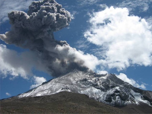 |
Figure 17. Photograph of an ash explosion on 15 March 2009 at 1156. Photo taken by R. Amache, courtesy of INGEMMET. |
Geological Summary. The truncated appearance of Ubinas, Perú's most active volcano, is a result of a 1.4-km-wide crater at the summit. It is the northernmost of three young volcanoes located along a regional structural lineament about 50 km behind the main volcanic front. The growth and destruction of Ubinas I was followed by construction of Ubinas II beginning in the mid-Pleistocene. The upper slopes of the andesitic-to-rhyolitic Ubinas II stratovolcano are composed primarily of andesitic and trachyandesitic lava flows and steepen to nearly 45°. The steep-walled, 150-m-deep summit crater contains an ash cone with a 500-m-wide funnel-shaped vent that is 200 m deep. Debris-avalanche deposits from the collapse of the SE flank about 3,700 years ago extend 10 km from the volcano. Widespread Plinian pumice-fall deposits include one from about 1,000 years ago. Holocene lava flows are visible on the flanks, but activity documented since the 16th century has consisted of intermittent minor-to-moderate explosive eruptions.
Information Contacts: Instituto Geológical Minero y Metalúrgico (INGEMMET), Av. Canadá 1470, San Borja, Lima 41, Perú (URL: http://www.ingemmet.gob.pe/); Buenos Aires Volcanic Ash Advisory Center (VAAC), Argentina (URL: http://www.smn.gov.ar/vaac/buenosaires/productos.php); La República Online (URL: http://www.larepublica.com.pe/).