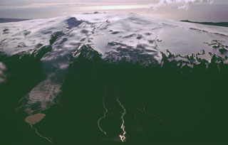
Report on Eyjafjallajokull (Iceland) — April 2010
Bulletin of the Global Volcanism Network, vol. 35, no. 4 (April 2010)
Managing Editor: Edward Venzke.
Research and preparation by Robert Andrews.
Eyjafjallajokull (Iceland) Large explosions from the summit crater; ash plumes close airspace in Europe
Please cite this report as:
Global Volcanism Program, 2010. Report on Eyjafjallajokull (Iceland) (Venzke, E., ed.). Bulletin of the Global Volcanism Network, 35:4. Smithsonian Institution. https://doi.org/10.5479/si.GVP.BGVN201004-372020
Eyjafjallajokull
Iceland
63.633°N, 19.633°W; summit elev. 1651 m
All times are local (unless otherwise noted)
During March 2010 the Icelandic Meteorological Office (IMO) and the Nordic Volcanological Center of the University of Iceland Institute of Earth Sciences (IES) reported seismic activity followed by an eruption of Eyjafjallajökull (BGVN 35:03), the first since 1823. During an initial eruptive phase from 20 March to 12 April 2010, lava flowed from fissures on Eyjafjallajökull's ENE flank. After a short hiatus in eruptive activity, an explosive eruptive phase began on 14 April under the ice-covered central summit caldera. The resulting plume caused an unprecedented disruption of air traffic and closure of airspace over northern and central Europe.
In the early morning of 14 April, the ash-loaded eruption plume rose to more than 8 km altitude and blew E. The eruption plume reached mainland Europe on 15 April, triggering the closure of airspace over large areas. Closure decisions by civil authorities were based on ash dispersal modeling provided by the London Volcanic Ash Advisory Center (VAAC), which is based in the United Kingdom's Met Office (figure 11). On 16 April some variability occurred in seismic tremor and tephra generation, but overall the eruptive pace remained stable and large closures of airspace continued.
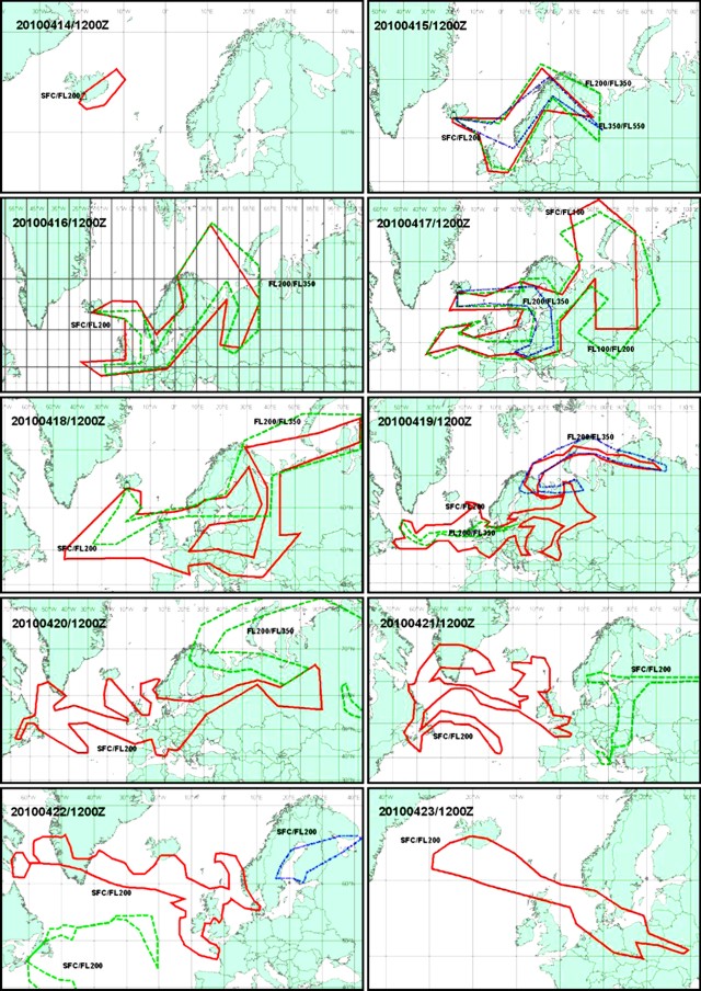 |
Figure 11. Compilation of graphic daily Volcanic Ash Advisories showing the assessed or inferred extent of ash plumes at 1200 UTC for 10 days, 14-23 April 2010. "SFC/ FL200" denotes the area covered by the ash advisories at altitudes from the surface to flight level 200 (20,000 ft, 6.1 km), "FL200/FL350" for altitudes of 20,000-35,000 ft (6.1-10.7 km), and "FL350/ FL550" for altitudes of 35,000-55,000 ft (10.7-16.8 km). Courtesy of London Volcanic Ash Advisory Center. |
The IES estimated the amount of erupted material during the first 72 hours of the eruption at the summit caldera (14-17 April 2010). Erupted products consisted of fragmental material, the majority being fine-grained airborne tephra. Some of the tephra came to rest in the ice cauldrons around the vents (in terms of uncompacted volume, 30 x 106 m3), some began filling the Gígjökulslón lagoon after transport by floods down the N-flank Gígjökull outlet glacier (10 x 106 m3), and airborne tephra blown to the E and S (100 x 106 m3). These uncompacted tephra volumes correspond to 70-80 x 106 m3 of dense magma, leading to an average magma discharge rate of ~ 300 m3/s. This was 10-20 times the average discharge rate in the preceeding flank eruption at Fimmvörduháls. Chemical analyses of ash samples revealed fluorine-rich intermediate eruptive products with silica content of 58%, more evolved than in the initial lava-producing phase of the eruptive activity (see table in BGVN 34:03).
On 17 April the ash plume rose to over 8 km altitude, blowing first to the E, and then, after about 0341 that day, blowing to the S. Ash fell around the volcano and there were at least 115 lightning strikes in vicinity of the eruption. When ash emissions on 17 April (figure 12) blew S they created an optically thicker band of ash that appeared to be surrounded by a much wider, less optically dense plume (figure 13). NASA analysts determined that the ash plumes were at two different altitudes, the narrow, more concentrated plume was above the more diffuse cloud, casting a shadow on the ash below. They said that according to the Icelandic Met Office, the upper parts of 17 April ash puffs reached 4.9-7.3 km altitude.
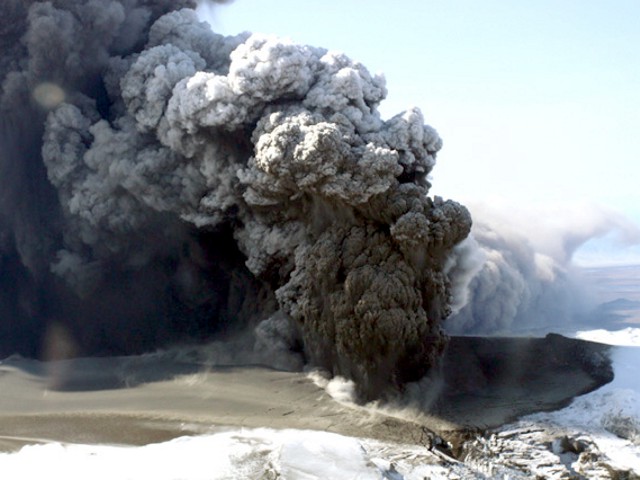 |
Figure 12. Aerial photograph of the dense ash plume rising from Eyjafjallajökull on 17 April 2010. Courtesy of Eyjólfur Magnússon, IES. |
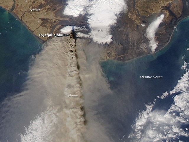 |
Figure 13. An Aqua-MODIS (Moderate Resolution Imaging Spectroradiometer) satellite image of Eyjafjallajökull taken on 17 April 2010. Ash blew S as both a dense band and a much wider, less dense plume (see text). Courtesy of NASA Earth Observatory: image by Jeff Schmaltz, MODIS Rapid Response Team; caption by Holli Riebeek. |
The 17 April example illustrates the difficulty of estimating the critical 'source terms' (boundary conditions) for modeling ash plume dispersal. Such models, which are regularly run by groups such as VAACs, volcano observatories, and their associated agencies, help assess where plumes might go in conditions such as darkness and overcast weather.
After about 1100 on 18 April, tremor intensified beyond levels maintained since 16 April. Daily solutions from continuous, 15-second GPS stations operated by IMO and IES, revealed centimeter-scale horizontal movements toward the center of the volcano, with some stations also registering centimeter-scale vertical elevation decreases. Tremor with a dominant frequency of 0.5 Hz remained continuous during this second eruptive phase.
During overflights on 19 April it was apparent that the ice cauldrons over the eruption site had melted back, forming a much larger cauldron ~ 2.5 km in diameter. Following an initial period of glacial flooding on 14-15 April, relatively little water drained from the ice cap's N flank. A largely open pathway for drainage in that direction, over and through the Gígjökull glacier, suggested significant meltwater would not pond at the eruption site.
On 19 April the plume rose only 600-900 m above the volcano's 1.7-km-high summit, yet as it drifted S it ascended to an altitude of 6.1 km. Later in the afternoon reports indicated maximum plume height around 4.6 km with ash clearly visible in the clouds. Samples collected 19 April show the same composition as early in the explosive phase, but the fluorine content was higher. Tephra deposited next to the craters was 20-30 m thick. Analogous conditions continued to exist for the following week.
Although there had been magma spatter at the vent area by 20 April, no significant lava flow had yet been detected. Heavy sound blasts were heard nearby, especially S and E of the mountain. Radar images acquired that day by the Icelandic Coast Guard showed no changes in the size of the cauldron since 19 April. Latest results from GPS stations showed deflation.
On 21 April, the eruption continued with less explosive activity. The eruption rate, estimated to be less than 30 m3/s (with a large uncertainty), was inferred to have declined over last few days to become an order of magnitude smaller than during the initial 72 hours of this phase. The northernmost one of two main craters in the summit caldera was active, and phreatomagmatic explosions occurred with some lava spatter at craters. Plume altitude was ~ 3-4 km, with local tephra dispersal towards the S.
Lava flows towards the N were thought to have begun around noon on 21 April. Evidence for this was the onset of semi-continuous discharge of meltwater from Gígjökull, steam rising from the N margin of the ice cauldron, and variations in tremor amplitude.
Beginning about 24 April the IES website contained detailed daily status reports of the eruption. Over the next few days there was little change, with the N crater remaining active, generating mild explosive activity and spatter. Steam plumes were rising where the N-flowing lava met ice.
The eruption site was seen clearly during an overflight on 27 April. The eruptive activity in the N ice cauldron was seen to be similar to conditions during the preceding four days, but a new crater had formed in the cauldron's SW corner. Erupted material continued to accumulate on the flanks of the crater. The rim of the crater was ~ 50 m lower than the surface of the surrounding ice cauldron. Spatter escaped the vent, reaching heights of 100-200 m. Unstable plumes of ash rose regularly from the vent. Lava continued to flow N, advancing ~ 1 km from the crater.
After an slight decrease in explosive activity early in May, activity then increased somewhat. The eruption was mixed, with the lava-producing phase being larger than the explosive phase. During this time, the plume was darker and wider than in the preceding week. Near-source tephra fall-out increased. On 4 May a flight by the Icelandic Coast Guard showed that the crater continued buildup in the northern-most ice cauldron. Lava flowed N and spread at an elevation of 500 m. The lava flow was about 200 m wide and lava channels that enter this flow were ~ 30-60 m wide. Increased seismicity up to 13 May suggested that new material was intruding from depth, and GPS observations indicated inflation.
Little change in activity was observed during 11-17 May. On 18 May an ongoing explosive eruption plume was mostly steady at 7 km altitude; the rate of magma eruption was over 200 tonnes/second. Tephra fallout was detected mainly to the NE, with some reaching the coast. Some tephra dispersed towards the W in the afternoon. The height of the ash plume decreased from 18-21 May, suggesting magma emission rates considerably less than 50 tonnes/second. By 21-22 May only a weak plume rose from the W part of the crater; both explosions and lava flows from the crater were absent. During 23-25 May there was no apparent eruptive activity, though there was still a considerable amount of steam coming from the crater. Aerial observers on 25 May (figure 14) saw blue smog (sulfuric gases) and smelled sulfur. Scientists who went to the crater on 25 May saw a small blast of ash, but mostly steam.
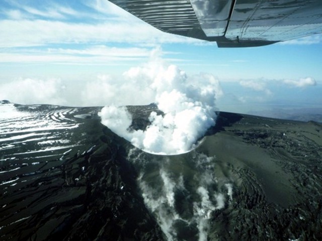 |
Figure 14. Steam discharged gently from the Eyjafjallajökull crater on 25 May 2010, with no ash. The N side of the crater was stained yellow with sulfides. Bluish fumes, sulfuric gases, blew S and SW. Using an infrared camera, IES scientists measured a temperature of 300°C in the crater and 50°C in the lava field to the N. Courtesy of Gunnar B. Gudmundsson, IES. |
On a 26 May IES expedition to the summit, tephra deposits in and around the E half of the crater were measured to be ~ 40 m thick close to the craters. Intense steam rose from the craters, with occasional small ashy explosions. Noise of intense boiling and or degassing came from the craters. Visibility to the bottom was limited due to steam. The crater rim was coated with fine ash that extended ~ 20 m out from the edge. A strong smell of sulfur came from around the craters.
IES and IMO reported widespread drifting of existing ash SW on 1 June, with abundant airborne dust in the capitol, Reykjavík. No lightning strikes were detected, and there was low discharge of meltwater from Gígjökull. Volcanic tremor was still higher than before the eruption, being rather steady since 22 May, but small pulses, mostly on the lowest frequency, were detected. Several small and shallow earthquakes under the volcano occurred on a daily basis. No significant GPS deformation was measured. There was still a considerable amount of steam coming from the crater.
Recent precursory intrusions. According to Sturkell and others (2009), "In 1994, and again in 1999, magma intrusion was detected under the southern slopes of Eyjafjallajokull. These intrusions had their center of uplift approximately 4 km southeast of the summit crater of the volcano and were associated with considerable seismic activity. After the intrusion event in 1999, crustal deformation and earthquake activity at Eyjafjallajokull have remained low." However, according to Pall Einarsson of IES, earthquake swarms and two more sill intrusions took place in 2009 (Einarsson, 2010).
Aviation impacts. According to Wall and Flottau (2010), more than 100,000 flights were canceled after the ash plume caused aviation authorities in many parts of Europe to close their airspace for several days. As compared with the same day of the previous week, flights decreased from about 27% on 15 April 2010 to almost 80% on 17-18 April, returning to 21% by 22 April. Wall, Flottau, and Mecham (2010) noted the difficulty if assessing the risk of flying through volcanic ash plumes which can have varying particulate concenrations and compositions.
The Finnish Air Force (FAF) Command Operations Division released a report of 21 April discussing jet engine damage from airborne ash from Iceland; at the time of this writing, the report was only available in Finnish. Routes of several FAF aircraft (figure 15) suggest that the flight distances were on the order of a few hundred kilometers. The Flightglobal website reported the FAF released images showing the effects of volcanic dust ingestion from inside the engines of a jet fighter that flew through the ash cloud on the morning of 15 April. One aircraft engine showed melted ash clearly visible on an interior surface. Another jet trainer flew through the plume carrying an air sampling pod to collect dust from the atmosphere at various altitudes, however the measurements have yet to be reported.
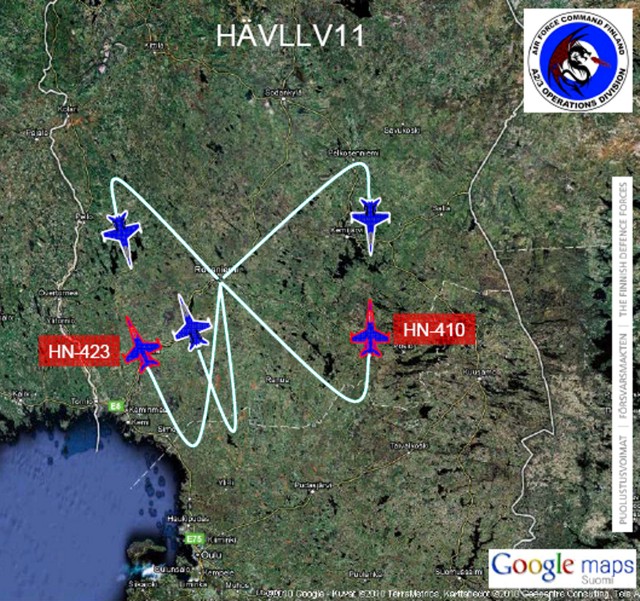 |
Figure 15. Map of southern Finland showing routes of FAF aircraft which a news report described as five Boeing F-18 Hornet fighters. The Gulf of Bothnia appears at the lower left, a water body with a NW-SE extent of ~200 km in this area. From this map it appears that the routes labeled HN-423 and HN-410 were on the order of 200 km. Courtesy of Finnish Air Force. |
References. Einarsson, P., 2010, The Eyjafjallajökull volcano, Iceland: Tectonic setting, structure, and magma plumbing during the current activity, Cities on Volcanoes (COV6), 30 May to 4 June 2010, Tenerife; 4.1-O-10.
Sturkell, E., Einarsson, P., Sigmundsson, F., Hooper, A., Ófeigsson, B.G., Geirsson, H., and Ólafsson, H., 2009, Katla and Eyjafjallajökull volcanoes, in Schomacker, A., Krüger. J., and Kjr, K.H., eds., The Mrdalsjökull Ice cap, Iceland - Glacial processes, sediments and landforms on an active volcano: Developments in Quaternary Sciences, v. 13, p. 5-12.
Wall, R., and Flottau, J., 2010. Out of the ashes: Rising losses and recriminations rile Europe's air transport sector: Aviation Week & Space Technology, v. 172, no. 16, p.23-25.
Wall, R., Flottau, J., and Mecham, M., 2010, Dirty little secret: Volcanic eruption raises more than dust as questions about flight safety fly: Aviation Week & Space Technology, v. 172, no. 16, p. 24-26.
Geological Summary. Eyjafjallajökull (also known as Eyjafjöll) is located west of Katla volcano. It consists of an elongated ice-covered stratovolcano with a 2.5-km-wide summit caldera. Fissure-fed lava flows occur on both the E and W flanks, but are more prominent on the western side. Although the volcano has erupted during historical time, it has been less active than other volcanoes of Iceland's eastern volcanic zone, and relatively few Holocene lava flows are known. An intrusion beneath the S flank from July-December 1999 was accompanied by increased seismic activity. The last historical activity prior to an eruption in 2010 produced intermediate-to-silicic tephra from the central caldera during December 1821 to January 1823.
Information Contacts: University of Iceland Institute of Earth Sciences (EIS), Nordic Volcanological Center, Sturlugata 7, Askja, 101 Reykjavik, Iceland (URL: http://www.earthice.hi.is/page/ies_volcanoes) [contributors:Páll Einarsson, ásta Rut Hjartardóttir, Magnus Tumi Gudmundsson, Freysteinn Sigmundsson, Eyjólfur Magnússon, Niels Oskarsson, Gudrun Larsen, Sigrun Hreinsdottir, Rikke Pedersen, Ingibjörg Jónsdóttir]; Icelandic Meteorological Office (IMO) (URL: http://en.vedur.is/) [Contributors:Steinunn Jakobsdóttir, Kristin S. Vogfjord, Sigurlaug Hjaltadottir, Gunnar B. Gudmundsson, Matthew J. Roberts; London VAAC (URL: http://www.metoffice.gov.uk/aviation/vaac/vaacup_vag.html); NASA Earth Observatory (URL: http://earthobservatory.nasa.gov/); Flightglobal (URL: http://www.flightglobal.com/articles/2010/04/16/340727/pictures-finnish-F-18-engine-check reveals effects of volcanic dust-16-04-2010-London-Flightglobal_com.mht).