Report on Sinabung (Indonesia) — July 2010

Bulletin of the Global Volcanism Network, vol. 35, no. 7 (July 2010)
Managing Editor: Richard Wunderman.
Sinabung (Indonesia) First Holocene eruption; ash explosions during August-September 2010
Please cite this report as:
Global Volcanism Program, 2010. Report on Sinabung (Indonesia) (Wunderman, R., ed.). Bulletin of the Global Volcanism Network, 35:7. Smithsonian Institution. https://doi.org/10.5479/si.GVP.BGVN201007-261080
Sinabung
Indonesia
3.17°N, 98.392°E; summit elev. 2460 m
All times are local (unless otherwise noted)
This report documents the first confirmed Holocene eruption at Sinabung, beginning on 27 August 2010 (figure 1). Sinabung is an elongated stratovolcano in the Karo plateau of northern Sumatra, Indonesia, ~80 km NNW of Toba. By 23 September the Center of Volcanology and Geological Hazard Mitigation (CVGHM) had reported six distinct eruptions (table 1), with another two (12 and 14 September) described by analysts at the Darwin Volcanic Ash Advisory Center (VAAC).
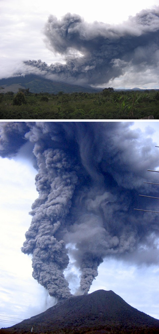 |
Figure 1. [Photos of the Sinabung eruption during 30 August-3 September 2010.] (top) Plume [on the evening of 3 September deflected by winds down the E flank], but spreading and rising at distance. (bottom) Dual plumes discharging [on 30 August, viewed from the NE], the one at left dropping minor ash in the near-source region. Note portions of antenna, presumably from the instrument telemetry system. The emission of dual plumes appears in photos and videos on the internet. Photo credit to Rahmanto (CVGHM). |
Table 1. Date and time of Sinabung explosive eruptions reported by CVGHM as of 22 September 2010.
| Date | Time | Comment |
| 27 Aug 2010 | 1830 | First known eruption in historical time begins. |
| 29 Aug 2010 | 0010 | Activity not described. |
| 30 Aug 2010 | 0623 | Low plumes (see text); press reports stated about six hours of eruption and two fatalities (see text). |
| 03 Sep 2010 | 0438 | Described as a "large eruption" in VAAC report but volcanic ash not identifiable in satellite imagery. |
| 03 Sep 2010 | 1759 | Large (off-scale) seismic signal, followed by tremor. |
| 06 Sep 2010 | 2337 | "7 September" eruption--rising to altitude of 5 to 8 km, the largest eruption yet seen (see subsection below). |
| 12 Sep 2010 | 0732 | Based on web camera, Darwin VAAC reported an ash plume to 4.3-4.6 km (FL140-FL150). |
| 14 Sep 2010 | 0915 | Based on web camera, Darwin VAAC assessed ash plume to 4.3 km altitude, drifting E. |
Although widespread press reports indicated that the last eruption occurred in 1600, this statement is incorrect. CVGHM reported that Sinabung had no radiocarbon dates documented after 1600, but that solfataric activity was observed at the summit in 1912.
An initial phreatic eruption reported by CVGHM occurred on 27 August 2010 following heavy rainfall. Later activity ejected juvenile material and was clearly magmatic. Ash and scoria fell to the E and SE, covering the villages of Sukameriah, Gangpitu, Sigarang-Garang, Sukadebi, and Susuk. On 28 August, only a cloud of sparse white smoke was observed, rising to a height of 20 m.
On 29 August observers heard a rumbling noise. The hazard status was changed to Alert Level 4 (on a scale of 1-4), resulting in authorities relocating people living within a 6 km radius of the volcano. At 1000 on 29 August a continuous eruptive signal was recorded, with amplitudes ranging from 0.5 to 1.5 mm. During the following night of 29-30 August activity became visible, and plumes reached 1,500 m above the crater rim. An explosion several hours later produced a white to medium dark plume. Subsequent explosions sent plumes to heights of ~ 100 m.
Footage of the eruption on 29 August showed two closely spaced ash plumes from vents near the summit. The ash plumes caused domestic flights to be diverted and the local Medan airport was closed. The next day (30 August) a second, more powerful, explosion generated an ash plume that rose 2 km above the crater. Media sources reported that 20,000-30,000 residents had evacuated as ash fell in nearby areas and a strong sulfur odor was reported. Nighttime video showed incandescent material descending an undisclosed flank of the volcano. One news report described six hours of activity on 30 August as "... raining ash and debris across several miles and killing two villagers who suffered respiratory and cardiac problems." Although these fatalities were commonly noted in press reports, the cause of these fatalities (and whether linked to the eruption or coincidental) remained uncertain.
The Darwin VAAC, based on information from CVGHM, reported a large explosion on 3 September. News reports stated that the explosion caused vibrations of homes and trees on the flanks, and generated a 3-km-high ash plume. According to news articles, during 31 August-7 September about 6,000 evacuees had been able to return home because activity had decreased.
CVGHM described the 7 September explosion as the largest of the eruptive episode. It produced a gray-to-black ash plume that rose to a nominal ~ 5 km above the crater and drifted SE. Strong vibrations caused by the explosion were detected as far away as ~ 8 km SE. Andrew Tupper (Darwin VAAC) noted that the plume rose soon after midnight on the 7th and presented huge difficulties for both visual and satellite observations. The 5-km plume altitude estimate came from ground observers (time of observation unknown), but a pilot report noted the altitude as ~ 8 km altitude (FL250, 25,000 feet, over the M300 route). A Volcanic Ash Advisory noted those values and traced the report to CVGHM and observations around 0530 on the 7th (local time and date).
Monitoring campaign. Although there is no continuous monitoring at Sinabung, there is a hazard map to provide guidance to local officials (figure 2). CVGHM installed a near-real-time video monitoring system (see Information Contacts) to assess the volcano's behavior during this active episode. Monitoring included four seismic stations high on the mountain with data telemetered to the observation post. Other monitoring included tilt (from a station at 1,200 m elevation), deformation (electronic distance measuring surveying three reflectors measured from Sukanalu Teran village, 4 km from the summit), and sulfur-dioxide emissions (mini-DOAS, and environmental monitoring using a Drager X-am 7000 in residential areas).
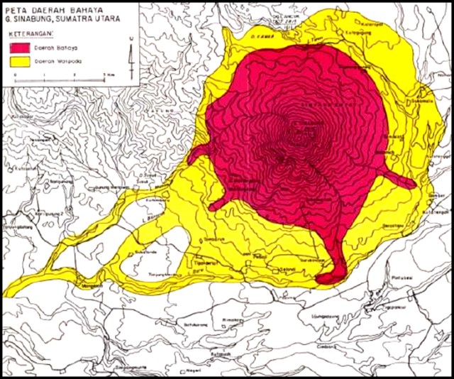 |
Figure 2. Hazard map of Sinabung showing two zones, an inner "danger zone" and an outer "alert zone." Courtesy of CVGHM. |
Geological Summary. Gunung Sinabung is a Pleistocene-to-Holocene stratovolcano with many lava flows on its flanks. The migration of summit vents along a N-S line gives the summit crater complex an elongated form. The youngest crater of this conical andesitic-to-dacitic edifice is at the southern end of the four overlapping summit craters. The youngest deposit is a SE-flank pyroclastic flow 14C dated by Hendrasto et al. (2012) at 740-880 CE. An unconfirmed eruption was noted in 1881, and solfataric activity was seen at the summit and upper flanks in 1912. No confirmed historical eruptions were recorded prior to explosive eruptions during August-September 2010 that produced ash plumes to 5 km above the summit.
Information Contacts: Center of Volcanology and Geological Hazard Mitigation (CVGHM), Jalan Diponegoro 57, Bandung 40122, Indonesia (URL: http://vsi.esdm.go.id/); Camera: http://merapi.bgl.esdm.go.id/aktivitas_merapi.php?page=aktivitas-merapi&subpage=kamera-g-sinabung); Darwin Volcanic Ash Advisory Centre (VAAC), Bureau of Meteorology, Northern Territory Regional Office, PO Box 40050, Casuarina, NT 0811, Australia (URL: http://www.bom.gov.au/info/vaac/); Associated Press; Daily Mail; Jakarta Post; CNN.