Report on Pagan (United States) — July 2010
Bulletin of the Global Volcanism Network, vol. 35, no. 7 (July 2010)
Managing Editor: Richard Wunderman.
Pagan (United States) Minor ash emissions in August 2010
Please cite this report as:
Global Volcanism Program, 2010. Report on Pagan (United States) (Wunderman, R., ed.). Bulletin of the Global Volcanism Network, 35:7. Smithsonian Institution. https://doi.org/10.5479/si.GVP.BGVN201007-284170
Pagan
United States
18.13°N, 145.8°E; summit elev. 570 m
All times are local (unless otherwise noted)
A small steam plume was observed at Pagan (figure 9) in April 2009 and a thermal anomaly was recorded in August 2009 (BGVN 34:09). Unofficial reports indicated that weak steam and gas plumes may have occurred between August 2009 and April 2010. Monitoring is by satellite and ground observers; there are no instruments installed.
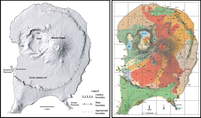 |
Figure 9. Two illustrations showing the N portion of Pagan Island. (left) A diagram with shaded-relief labeling some key features. (right) Geologic map of Pagan Island (see Trusdell and others, 2006, for lithologic key). |
According to the U.S. Geological Survey (USGS), steam and gas plumes were observed in MODIS satellite images on 21, 22, and 28 April 2010. Minor steam and gas plumes have been observed often in the past, and do not necessarily indicate the imminence of an eruption.
A visitor to the island reported a minor gas emission on 3 May 2010, and a steam and gas plume was observed on ASTER imagery on this date. On 6 May 2010, minor ashfall was confirmed and steam and gas emissions were seen on satellite imagery.
During 7-28 May 2010, satellite imagery revealed steam plumes from Pagan that drifted W. On 21 and 23 May, a U.S. Fish and Wildlife Service research crew camping on the island reported that a trace amount of ash was deposited on their tents from a possible ash emission during the night. Due to concerns about the potential for escalation of activity and the subsequent eruption of Sarigan (~ 150 km S of Pagan), the research crew left Pagan Island on 30 May 2010; since that time no direct observations of activity have been made.
Minor gas and steam plumes continued into June. A false-color satellite image on 3 June (figure 10) showed a minor gas-and-steam plume; the blue tint of the plume hints that it may be rich in sulfate aerosols. During 18 June-2 July, minor gas-and-steam plumes were observed in satellite imagery. According to the Washington Volcanic Ash Advisory Center, a small cloud of ash mixed with a gas plume was seen on 5 July in satellite imagery.
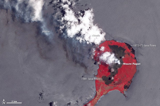 |
Figure 10. False-color image of Pagan acquired 3 June 2010 by the Advanced Spaceborne Emission and Reflection Radiometer aboard NASA's Terra satellite. Vegetation, colored bright red, stands in contrast to dark lava flows. The central flows were erupted in 1981, while the smaller flows on the northeastern coastline date to 1872-1873. Courtesy of NASA Earth Observatory; image by Jesse Allen and Robert Simmon using data from the NASA/GSFC/METI/ERSDAC/JAROS, and U.S./Japan ASTER Science Team; caption by Robert Simmon. |
On 11 August, observers working on a boat reported that a low-level ash eruption produced a diffuse, dark-colored ash-and-steam plume that rose to an altitude of 1.5 km and caused minor ashfall on northern Pagan Island and the surrounding ocean.
In September 2010, volcanic unrest continued at Pagan, with occasional weak steam and gas plumes. When accessed in September 2010, MODVOLC thermal alerts have been absent for the last 10 years.
Reference. Trusdell, FA, Moore, RB, and Sako, MK, 2006, Preliminary Geologic Map of Mount Pagan Volcano, Pagan Island, Commonwealth of the Northern Mariana Islands, U.S. Geological Survey, Open-File Report 2006-1386 (URL: http://pubs.usgs.gov/of/2006/1386/).
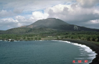
Geological Summary. Pagan Island, the largest and one of the most active of the Mariana Islands volcanoes, consists of two stratovolcanoes connected by a narrow isthmus. Both North and South Pagan stratovolcanoes were constructed within calderas, 7 and 4 km in diameter, respectively. North Pagan at the NE end of the island rises above the flat floor of the northern caldera, which may have formed less than 1,000 years ago. South Pagan is a stratovolcano with an elongated summit containing four distinct craters. Almost all of the recorded eruptions, which date back to the 17th century, have originated from North Pagan. The largest eruption during historical time took place in 1981 and prompted the evacuation of the sparsely populated island.
Information Contacts: Emergency Management Office of the Commonwealth of the Northern Mariana Islands (EMO-CNMI) and USGS Volcano Hazards Program, PO Box 100007, Saipan, MP 96950, USA (URL: http://www.cnmihsem.gov.mp/ and http://volcanoes.usgs.gov/nmi/activity/); Washington Volcanic Ash Advisory Center, Satellite Analysis Branch (SAB), NOAA/NESDIS E/SP23, NOAA Science Center Room 401, 5200 Auth Rd, Camp Springs, MD 20746, USA (URL: http://www.ospo.noaa.gov/Products/atmosphere/vaac/); Jesse Allen and Robert Simmon, NASA Earth Observatory (URL: http://earthobservatory.nasa.gov/); Hawai'i Institute of Geophysics and Planetology (HIGP) Thermal Alerts System, School of Ocean and Earth Science and Technology (SOEST), Univ. of Hawai'i, 2525 Correa Road, Honolulu, HI 96822, USA (URL: http://modis.higp.hawaii.edu/)