Report on Popocatepetl (Mexico) — August 2010

Bulletin of the Global Volcanism Network, vol. 35, no. 8 (August 2010)
Managing Editor: Richard Wunderman.
Popocatepetl (Mexico) Seismicity and small ash plumes ongoing through October 2010
Please cite this report as:
Global Volcanism Program, 2010. Report on Popocatepetl (Mexico) (Wunderman, R., ed.). Bulletin of the Global Volcanism Network, 35:8. Smithsonian Institution. https://doi.org/10.5479/si.GVP.BGVN201008-341090
Popocatepetl
Mexico
19.023°N, 98.622°W; summit elev. 5393 m
All times are local (unless otherwise noted)
This report discusses the time interval April 2009 through mid-October 2010, a period in which activity at Popocátepetl continued in the form of tremor, numerous earthquakes, and many small ash plumes. Our most recent report on Popocatépetl volcano (BGVN 34:03) described activity from April 2007 through April 2009.
According to a report from Julie Roberge, Universidad Nacional Autonóma de México (UNAM), summarizing activity at Popocatépetl in 2009, the Centro Nacional de Prevencion de Desastres (CENAPRED) reported no significant changes for that year in the volcanic activity, which consisted of low-intensity earthquakes and tremors and constant degassing (exhalation), sometimes accompanied by ash emissions of variable intensity (figure 56). Table 20 gives a listing of plume activity from 1 April 2009 through 4 October 2010 for plumes observed to have some ash. Based on information from Roberge, CENAPRED, the Mexico City Meteorological Watch Office, and the Washington Volcanic Ash Advisory Center, there were ~11 ash plumes reported that rose ~1 km above the summit. Other plumes were seen during this period, many of them emitting steam and gas, sometimes with slight amounts of ash, but whose altitudes were unreported.
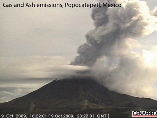 |
Figure 56. Photo of Popocatépetl showing an ash emission on 9 October 2009. The gas and ash plume column reached up to 3 km above the summit. Courtesy of CENAPRED. |
Table 20. Reported plumes above Popocatépetl's summit that contained some ash between 1 April 2009 and 4 October 2010. Data provided by the MWO (Meteorological Watch Office), Washington VAAC, and CENAPRED (abbreviated CEN).
| Dates | Altitude (km) | Direction | Reporting Source | Comments |
| 01 Apr 2009 | 1 | -- | CEN | Small ash emission on 2 April |
| 29 Apr 2009 | -- | -- | CEN | Slight amounts of ash |
| 27-29 May 2009 | -- | -- | CEN | Slight amounts of ash |
| 08-09 Jun 2009 | -- | -- | CEN | Slight amounts of ash |
| 10, 12-17 Aug 2009 | -- | -- | CEN | Occasional slight amounts of ash |
| 20 Aug 2009 | 8.2 | 13 km W | MWO, VAAC | Ash plume |
| 20-25 Aug 2009 | -- | -- | CEN | Slight amounts of ash |
| 25 Aug 2009 | -- | 35 km NNE | MWO, VAAC | -- |
| 26-27 Aug 2009 | -- | -- | CEN | Slight amounts of ash |
| 27 Aug 2009 | 6.1 | SW | MWO, VAAC | -- |
| 02-03 Sep 2009 | -- | -- | CEN | Slight amounts of ash |
| 10-14 Sep 2009 | -- | -- | CEN | Slight amounts of ash |
| 03-06 Oct 2009 | -- | -- | CEN | Slight amounts of ash |
| 09 Oct 2009 | ~3 | -- | CEN | -- |
| 29 Oct 2009 | 6.4 | -- | CEN | -- |
| 14 Nov 2009 | 7.4 | -- | CEN | -- |
| 14-17 Nov 2009 | -- | -- | CEN | Steam-and-gas plumes sometimes contained ash |
| 18-20 Nov 2009 | -- | -- | CEN | Steam-and-gas plumes sometimes contained ash |
| 21 Nov 2009 | 8.9 | E | CEN | Small explosion; ashfall in Atlixco (23 km SE), Huejotzingo (27 km NE), and areas in the state of Tlaxcala |
| 10-11 Jan 2010 | -- | -- | CEN | Minor amounts of ash |
| 27 Jan-01 Feb 2010 | -- | -- | CEN | Minor amounts of ash |
| 28 Feb-01 Mar 2010 | -- | -- | CEN | Small amounts of ash |
| 07-13 Apr 2010 | -- | -- | CEN | Minor amounts of ash |
| 02-03, 07-08 Jun 2010 | -- | -- | CEN | Small amounts of ash; a few periods of harmonic tremor |
| 07 Jun 2010 | 7.6 | NNE | CEN | Small amounts of ash |
| 08 Jun 2010 | 8.4 | -- | MWO | Moderate explosion |
| 11 Jun 2010 | 6 | 9 km W | MWO | Ash and gas |
| 23 Aug 2010 | 1 | -- | CEN | -- |
| 30 Sep-04 Oct 2010 | -- | -- | MWO | Small amounts of ash |
Roberge reported that, during 2009, the number of gas exhalations decreased from January through April, returning to highs in June and August, and decreasing again into December. As was observed in previous years, the amount of ash in the eruptions was modest compared to total gas emissions (figure 57). Other than peaks in January and August, the number of earthquakes in 2009 stayed low throughout the year; the number tremor episodes seemed to be inversely related to gas emissions (figure 58).
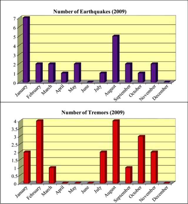 |
Figure 57. Histograms of the number of gas exhalations and percentage of exhalations containing ash in 2009. Courtesy of Roberge (2010). |
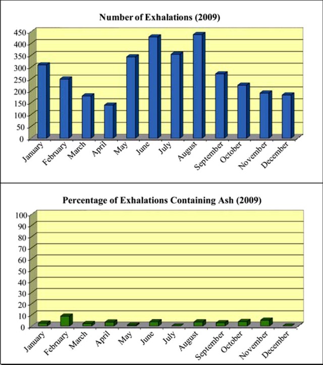 |
Figure 58. Histogram of the number of earthquakes and tremors in 2009. Courtesy of Roberge (2010). |
MODVOLC Thermal Alerts. Between 5 November 2009 and 20 October 2010, thermal anomalies at Popocatépetl were reported as being detected every month by the MODVOLC system. The number of days showing thermal alerts per month ranged from one to fifteen (the latter, March 2010), mostly one pixel imaged during an overflight, but occasionally two pixels. Unusually, from 4 May to 5 November 2009, no thermal alerts were detected; one alert was measured in May 2009, and 4 in April 2009.
Geological Summary. Volcán Popocatépetl, whose name is the Aztec word for smoking mountain, rises 70 km SE of Mexico City to form North America's 2nd-highest volcano. The glacier-clad stratovolcano contains a steep-walled, 400 x 600 m wide crater. The generally symmetrical volcano is modified by the sharp-peaked Ventorrillo on the NW, a remnant of an earlier volcano. At least three previous major cones were destroyed by gravitational failure during the Pleistocene, producing massive debris-avalanche deposits covering broad areas to the south. The modern volcano was constructed south of the late-Pleistocene to Holocene El Fraile cone. Three major Plinian eruptions, the most recent of which took place about 800 CE, have occurred since the mid-Holocene, accompanied by pyroclastic flows and voluminous lahars that swept basins below the volcano. Frequent historical eruptions, first recorded in Aztec codices, have occurred since Pre-Columbian time.
Information Contacts: Julie Roberge, Instituto de Geología, Dept. Geoquimí ca, Universidad Nacional Autonóma de México (UNAM - National Autonomous University of Mexico), Ciudad Universitaria, Coyoacán D.F.(Federal District of Mexico City) 04510, Mexico; Hawai'i Institute of Geophysics and Planetology (HIGP) Thermal Alerts System, School of Ocean and Earth Science and Technology (SOEST), Univ. of Hawai'i, 2525 Correa Road, Honolulu, HI 96822, USA (URL: http://modis.higp.hawaii.edu/); Centro Nacional de Prevencion de Desastres (CENAPRED), Av. Delfín Madrigal No.665. Coyoacan, México D.F. 04360, México (URL: https://www.gob.mx/cenapred/); Washington Volcanic Ash Advisory Center (VAAC), Satellite Analysis Branch (SAB), NOAA/NESDIS E/SP23, NOAA Science Center Room 401, 5200 Auth Road, Camp Springs, MD 20746, USA (URL: http://www.ospo.noaa.gov/Products/atmosphere/vaac/).