Report on Ol Doinyo Lengai (Tanzania) — September 2010

Bulletin of the Global Volcanism Network, vol. 35, no. 9 (September 2010)
Managing Editor: Richard Wunderman.
Ol Doinyo Lengai (Tanzania) Quiet in May, active vents and lava flows in October 2010
Please cite this report as:
Global Volcanism Program, 2010. Report on Ol Doinyo Lengai (Tanzania) (Wunderman, R., ed.). Bulletin of the Global Volcanism Network, 35:9. Smithsonian Institution. https://doi.org/10.5479/si.GVP.BGVN201009-222120
Ol Doinyo Lengai
Tanzania
2.764°S, 35.914°E; summit elev. 2962 m
All times are local (unless otherwise noted)
Two strong earthquakes within a 24-hour period occurred in the region of Ol Doinyo Lengai in early May 2010; these earthquakes were intense enough to shake the trees within a camp located 15 km NW. Observations were made during an ascent by scientists on 18 May 2010 and during an overflight in October.
Observations were made by scientists Laura Carmody, Adrian P. Jones, Matthew J. Genge, and Wendy Nelson, during their ascent on 18 May 2010 (Carmody and others, 2010). They used an infrared range finder to make measurements, reported to be accurate to ~1 m. The group found the active N crater to be elliptical in shape (N-S diameter = 262 m and E-W diameter = 289 m, both rim to rim). The irregular crater floor, at an estimated maximum depth of 172 m below the rim, was surrounded by near-vertical lower walls leading to the upper ~45-degree slopes.
Observations suggest that the volcano is in a period of reduced activity following the explosive eruption in 2007 (BGVN 32:02, 32:11, and 33:02), with no effusive lava production on the crater floor, although moving magma could be heard below the surface, with assumed pockets of degassing causing disturbances around cavities in the crater floor at intervals of 15-20 min.
Carmody observed at least four open vents on the crater floor that appeared darker than their surroundings. A few of these cavities looked to be the beginning of meter-scale hornito building. Some areas near the crater wall appeared to have darker lava flow-like features from recent lava extrusion.
The crater floor was covered with rocky debris, including tilted broken lava plates (5-10 m scale), possibly from recent magma withdrawal, and various gravity collapse material from the over-steepened and locally unstable inner crater walls. These collapses, from two sites around the ash cone (NE and SW sectors of the rim), developed debris scars ~30 m wide, with some material appearing to have fallen en masse into the crater, while other sections became destabilized.
The crater walls exposed an upper series of lapilli-dominated tephra with white to ochre colors up to 30 m thick that mantled the topography of underlying gray to white carbonatite lava flows and lapilli tuff formed within the previous crater. A ~5-m-wide sub-vertical dike-like intrusion with irregular boundaries was observed cutting most of the N wall of the crater, which may represent a vent plugged in the most recent (2007) activity. Remobilization of water-soluble carbonates from the white, lapilli-dominated tephra exposed on the rim of the crater was indicated by numerous meter-scale white stalactites appended to overhangs (figure 145).
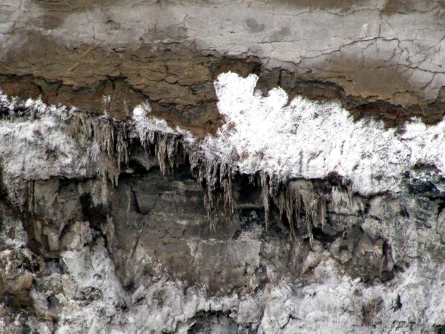 |
Figure 145. Ol Doinyo Lengai crater wall stalactites seen 18 May 2010. For scale, some stalagtites reached 1 m long. Courtesy of Carmody and others (2010). |
There were at least three visible sites of active degassing, two from fissures on the crater rim ash cone (figure 146) and one from a vent on the crater floor. These plumes were white in color and had a "rotten-egg" sulfurous smell, suggesting the presence of hydrogen sulfide (H2S). The ash cone on the NW approach to the crater showed up to knee-deep alteration, with the lava's color turning to dark brown, yellow, and black soil-like products, with pockets of blue and green material accompanied by the distinctive "rotten-egg" (sulfurous) smell. Similar colorations could be seen on the steep W crater wall just below the slope of ash. Rocky exposures of pyroclastic breccia on the upper NW slopes, immediately below the ash cone, had numerous expansion cracks and fissures suspected of recently releasing gas, as indicated by large numbers of dead insects. A gas haze in the same area suggested additional diffuse degassing from the upper flanks.
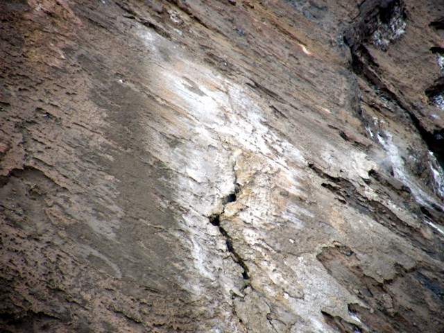 |
Figure 146. Gas fissure in Ol Doinyo Lengai crater rim penetrating the ash-covered slope. Courtesy of Carmody and others (2010). |
The upper slopes were partly covered with indurated volcanic ash from 2007, recently flushed with water from seasonal rains (locally terminating a dry period from 2007). On the middle to lower slopes, the same white ashy crust on radial topographic highs (including the pathway) funneled surface water into deeply incised gullies and broke underfoot to reveal dark locally water-saturated ash.
Sprouting vegetation (especially grasses and acacia) were vigorously starting to return in response to the recent rain. The flanks varied in slope from 45-55 degrees beyond the halfway point, and much of the recent ash had been removed along deeply incised water-runoff gullies. A white aerated crust of carbonate, under 1 mm thick, covered much of the upper slopes. Actively erosive runoff channels extending down N towards Lake Natron were noted around perhaps half of the base of the volcano.
The large lava flows prior to the 2007 explosive eruption were visible on the upper flanks, with the 2006 flow extending down to the lower flanks. These flows appeared white in color, making them stand out "like glaciers" from the dark gray ash (figure 147).
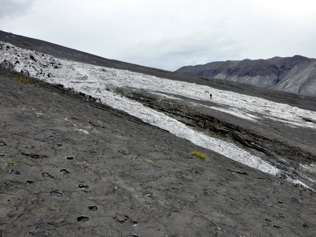 |
Figure 147. Indurated slopes on the flank of Ol Doinyo Lengai. The pre-2007 lava flows appear white, in great contrast to the dark gray ash. For scale, a figure is standing on the far white lava flow. Courtesy of Carmody and others (2010). |
During an overflight of the crater in October, Michael Dalton-Smith observed some magmatic activity typical of Ol Doinyo Lengai prior to the 2007-2008 eruption. Three active vents were on the SE crater floor surrounded by dark lava (figure 148). Two lava flows had traveled downslope of the vents.
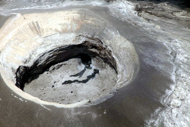 |
Figure 148. Two lava flows in the SE part of Ol Doinyo Lengai's crater were observed during an October 2010 overflight. Courtesy of Michael Dalton-Smith. |
Reference. Carmody, L., Jones, A.P., Genge, M.J., and Nelson, W., 2010, Monthly Bulletin-Oldoinyo Lengai May 2010, informal report.
Additional References. Dawson, J.B., 2008, The Gregory Rift Valley and Neogene-Recent Volcanoes of Northern Tanzania, Geological Society, London, Memoir 33, London, Bath, 102 pp.
Sherrod, D., Mollel, K., and Nantatwa, O., 2010, Oldonyo Lengai: Trip Report March 12-14, 2010, informal report (URL: http:/Sherrod_OldonyoLengai_March12_20106-1
Geological Summary. The symmetrical Ol Doinyo Lengai is the only volcano known to have erupted carbonatite tephras and lavas in historical time. The prominent stratovolcano, known to the Maasai as "The Mountain of God," rises abruptly above the broad plain south of Lake Natron in the Gregory Rift Valley. The cone-building stage ended about 15,000 years ago and was followed by periodic ejection of natrocarbonatitic and nephelinite tephra during the Holocene. Historical eruptions have consisted of smaller tephra ejections and emission of numerous natrocarbonatitic lava flows on the floor of the summit crater and occasionally down the upper flanks. The depth and morphology of the northern crater have changed dramatically during the course of historical eruptions, ranging from steep crater walls about 200 m deep in the mid-20th century to shallow platforms mostly filling the crater. Long-term lava effusion in the summit crater beginning in 1983 had by the turn of the century mostly filled the northern crater; by late 1998 lava had begun overflowing the crater rim.
Information Contacts: J.B. Dawson, The University of Edinburgh, Department of Geology and Geophysics, Edinburgh, United Kingdom; Frederick Belton, Developmental Studies Department, PO Box 16, Middle Tennessee State University, Murfreesboro, TN 37132, USA (URL: http://oldoinyolengai.pbworks.com/); Laura Carmody, Department of Earth Science, University College London, Gower Street, London, WC1E 6BT, United Kingdom; Adrian P. Jones, Department of Earth Science, University College London, Gower Street, London, WC1E 6BT, United Kingdom; Matthew J. Genge, Department of Earth Science and Engineering, Royal School of Mines, Prince Consort Road, Imperial College London, SW7 2BP United Kingdom; Wendy Nelson, Department of Terrestrial Magnetism, Carnegie Institution of Washington, 5241 Broad Branch Rd, NW Washington, DC 20015, USA; Michael Dalton-Smith (URL: http://digitalcrossing.ca/).