Report on Nyiragongo (DR Congo) — September 2010

Bulletin of the Global Volcanism Network, vol. 35, no. 9 (September 2010)
Managing Editor: Richard Wunderman.
Edited by Jen Fela.
Nyiragongo (DR Congo) June 2010 crater expedition reveals continuously active lava lake
Please cite this report as:
Global Volcanism Program, 2010. Report on Nyiragongo (DR Congo) (Fela, J., and Wunderman, R., eds.). Bulletin of the Global Volcanism Network, 35:9. Smithsonian Institution. https://doi.org/10.5479/si.GVP.BGVN201009-223030
Nyiragongo
DR Congo
1.52°S, 29.25°E; summit elev. 3470 m
All times are local (unless otherwise noted)
The following is based on a report of a field expedition to Nyiragongo's summit crater (visits to the summit are infrequent) during June 2010 and satellite observations through September 2010. Lava fountaining, gas plumes, and tremor were detected at Nyiragongo during January-May 2009 (BGVN 35:04).
Crater expedition during 14-24 June. Field observations during a 14-24 June expedition into the crater showed the lava lake to be continuously active, with rapid movement of cooled plates of fresh rock.
The expedition team included members from the Société de Volcanologie Geneve (SEG, Geneva, Switzerland), the Second University of Naples (Naples, Italy), the University of Massachusetts-Boston, l'Observatoire Volcanologique de Goma (D.R. Congo), and the United Nations Office of Project Services (UNOPS) (Copenhagen, Denmark).
Sample collection areas included exterior flows from previous eruptions on the edifice flanks (1977 and 2002 flows) and within the crater, where the team labeled key features with Greek symbols (figure 45). The team recognized three lava terraces: 1) β (pre-1977 eruption), 2) γ (post-1977 eruption-2002 eruption), and 3) ε, a newly formed (post-2002) terrace.
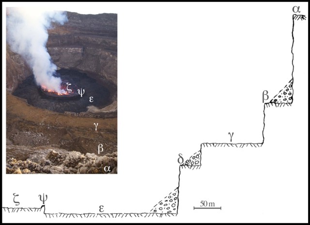 |
Figure 45. Topography of the interior of the Nyiragongo summit crater, shown in the photo looking N and in the sketch trending from the S rim radially inward to the molten lake (ζ). The total elevation change from the rim (α, at elevation 3,425 m) to the crater floor (ε) is ~400 m. The structures shown here are absent from portions of the circumference due to the collapsing of some parts of the terrace. Part δ is not a true terrace, but rather a small flat area, due to the collapsing of parts of the second terrace (not visible in the inset image). The team's base camp was located on the second terrace, γ. The lava lake rim or levee (ζ) was 15-20 m above the crater floor (ε) and is confined within an almost circular scoria wall (ψ). The whole crater floor declines slightly E and overflows the lake more frequently in that direction. Both the vertical and horizontal scales are equivalent. Courtesy Burgi and others (in preparation). |
Burgi and others (in preparation) devised a schematic to illustrate some of the key issues in Nyiragongo's magma storage and feeding systems at depth. Tentatively, the lower estimate of magma volume is ~10 x 106 m3. The morphology of the lava lake at depth is little-known, but it may be partly or completed filled by molten material. In this latter case, Burgi and others tentatively estimated the total volume of molten material inside the volcano to be ~50 x 106 m3.
Field collections included samples from each terrace, fresh lava samples from the lake (19-22 June 2010), and various samples from fumaroles. Samples collected at selected fumaroles included fumarolic gases, steam condensates, soils, and weathered volcanic clays.
Nyiragongo lavas generally display a distinctly alkaline-rich (ultra-potassic), low-silica, mafic foiditic basalt composition that results in the lowest recorded viscosity among terrestrial lavas. The major element chemistry of the 2010 lava samples was reasonably similar to the data reported for the 2002 eruption (e.g., Chakrabarti and others, 2008).
The team found the most intense zones of fumarolic activity along a N- and NNE-trending fracture set on the southern side of the edifice. Those fumaroles sit between Nyiragongo and the northern margin of Lake Kivu (including the city of Goma). Almost all of the observed fumarolic activity occurred in the crater on both the crater walls and on portions of terraces.
On terrace 3, fumaroles were mainly present in the E (E-NE quadrant) part of the crater floor, on a much smaller area than terraces 1 and 2.
The temperature of the fumaroles ranged to a maximum of over ~300°C. Fumaroles approximately in the center of terrace 2 showed high temperatures (up to 300°C) and high sulfur concentrations (~100-400 ppm S), as compared with consistently decreasing temperatures and sulfur contents towards the E (80-100°C and 7-40 ppm S). The team reported that this lineament was in line with fractures that produced lava flows during the 2002 eruption and with the Shaheru flank sub-edifice. The team noted that the observations of fumarolic activity and chemical composition may have been biased by their point of observation.
For the fumarolic samples, the team analyzed the composition of the condensates (table 10). In general, the condensates from each terrace can be characterized as acidic (pH 2.18-3.21), with widely variable chemistry.
Table 10. Chemical data determined at Nyiragongo crater fumaroles at terraces 1, 2, and 3 ("--" = not determined). Courtesy Burgi and others (in preparation).
| Location | Sample | Temp. (°C) | pH | EC (µs) | F- (mg/L) | Cl- (mg/L) | Br- (mg/L) | NO3- (mg/L) | PO43- (mg/L) | SO42- (mg/L) |
| Terrace 1 | PT 2-1 | 85 | -- | -- | 1.4 | 3.7 | 6.2 | 0 | 0 | 97.2 |
| Terrace 2 - SSW | LT3-PT2 | 105 | -- | -- | 7.7 | 6.2 | 0 | 0 | 175.2 | 24 |
| Terrace 2 - Central (south) | S1-PT2 | ~300 | -- | -- | 6.5 | 41.9 | 0 | 2 | 344.1 | 412.8 |
| Terrace 2 - Central (south) | S2-PT2 | 115 | 2.18 | 1842 | 24.5 | 77 | 0 | 0 | 95.9 | 107.5 |
| Terrace 2 - Central (south) | S3-PT2 | 110 | 2.46 | 882 | 15.6 | 9 | 0 | 0 | 0 | 332.7 |
| Terrace 2 - East | PT2-LT1 | 80 | 2.57 | 322 | 0.1 | 0.2 | 0 | 0 | 0 | 42.5 |
| Terrace 2 - East | PT2-LT2 | 90 | 2.28 | 1520 | 0.8 | 19 | 0 | 0 | 0 | 190.6 |
| Terrace 2 - East | PT2-LT3 | 90 | 2.19 | 2359 | 1.1 | 3.9 | 0 | 0 | 0 | 365.3 |
| Terrace 2 - East | PT2-F | 100 | 2.79 | 48 | 0 | 0 | 0 | 0 | 0 | 6.9 |
| Terrace 3 | PT3-2 | ~100 | 3.21 | 464 | 14.2 | 18.4 | less than 0.03 | 0.1 | 15.3 | 301.4 |
| Terrace 3 | PT3-1 | ~100 | 2.88 | 380 | 1.7 | 1.2 | 0 | 0.1 | 0 | 99.9 |
The team found that the lava lake's E-W axis was ~230 m across. In those instances where a proper cross-lake measurement was achieved, the team found the N-S distance to be ~220 m. Thus, the approximately circular lava lake's surface was ~40,000 m2 in area.
If the lava lake were ~500 m deep and in the shape of an inverted cone, with 40 m and 225 m for bottom and top diameters, respectively, the team conservatively estimated its volume as approximately 7.5-10 x 106 m3.
Since the last eruption (January 2002), the surface of the lava lake has risen regularly (figure 46). The surface ascends towards the crater rim due to a constant influx of magma at an approximate average rate of ~4.8 m per month (~57 m/year).
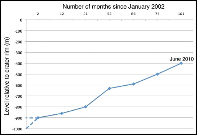 |
Figure 46. A plot showing the rise of Nyiragongo's crater floor, in meters below the crater rim, during January 2002 to June 2010. The January 2002 level is not known with precision, but was probably between 900 and 1000 m below the rim. Adapted from Tedesco and others (2007) and Durieux (2008). Courtesy Burgi and others (in preparation). |
Satellite observations. A 5 May 2009 report by UNOSAT showed thermal anomalies, which defined a 1.5 x 3 km band centered over the crater during 10 April-4 May 2009. UNOSAT analysts considered the anomalies as "likely to represent active fires and/or volcanic material on the surface." Because of thermal radiance from its lava lake, MODVOLC alerts were frequent for years, through October 2010, centered over the crater. The number of alerts at Nyiragongo were dwarfed during January 2010 due to 17.65 ? 5.98 x 10⁶ m2 of lavas erupted at Nyamuragira (as discussed in BGVN 35:08) and flowing in the area between the two volcanoes.
A small area of satellite-detected thermal anomalies located over the main crater of Nyiragongo was detected on the evening of 4 January 2010 by the MODIS on the Aqua satellite. In their 7 January 2010 report on this and a much larger anomaly over the Nyamuragira volcano area, UNOSAT analysts noted that it is likely that not all anomalies were detected in the area because of dense cloud cover or gaps in satellite coverage.
The Washington VAAC reported a large sulfur dioxide plume in the vicinity of Nyamuragira and Nyiragongo during 10-11 January 2010. Based on analyses of satellite imagery, the Toulouse VAAC reported that, during 30-31 January, a diffuse plume drifted 240 km W. The plume could have come from one or both of these volcanoes, but, given the known vigorous lava outpourings at Nyamuragira, that volcano would seem the dominant source.
The Advanced Land Imager (ALI) on NASA's Earth Observing-1 (EO-1) satellite captured images of a plume from the summit of Nyiragongo on 27 June and 28 July 2009 and again on 28 May (figure 47), 24 July, and 3 August 2010. The plume appeared pale blue-gray, suggesting it was rich in sulfur dioxide, and generally drifted S-SW.
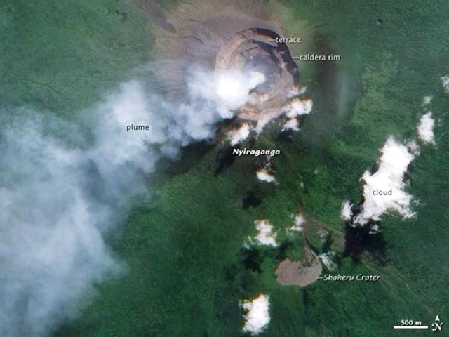 |
Figure 47. Nyiragongo's steam and volcanic gases were visible rising from the surface of the lava lake on 28 May 2010. This image was acquired by the ALI imager aboard NASA's EO-1 satellite. According to NASA Earth Observatory analysts, the plume was emanating from the molten surface of the lake. The analysts interpreted the dark gray/black area on the caldera floor as a crust of solidified lava. Shaheru crater, ~2 km S of the summit, was the site of active fissures in both 1977 and 2002. Courtesy Jesse Allen and Robert Simmon, NASA Earth Observatory. |
References. Burgi, P.-Y., Darrah, T., Balagizi, C., Karume, K., Campbell, M. E., Poreda, R. J., Tedesco, D., [in preparation], Assessment of Eruptive Activity and Lava Chemistry at Mount Nyiragongo, DRC, June 2010.
Chakrabarti , R., Sims, R. W. W., Basu, A.R., Reagan , M. and Durieux, J., 2008, Timescales of Magmatic Processes and Eruption Ages of the Nyiragongo volcanics from 238U-230Th-226Ra-210Pb disequilibria: Earth and Planetary Science Letters, v. 288, 1-2, 30 October 2009, p. 149-157. doi:10.1016/j.epsl.2009.09.017.
Durieux, J., 2008, Rapport de mission de terrain au volcan Nyiragongo: UNOPS: Copenhagen, Denmark, 2 April 2008, 3 p.
Tedesco, D., Vaselli, O., Papale, P., Carn, S. A., Voltaggio, M., Sawyer, G. M., Durieux, J., Kasareka, M., Tassi, F., 2007, January 2002 Volcano-Tectonic Eruption of Nyiragongo Volcano, Democratic Republic of Congo: J. Geophys. Res., v. 112, B09202, doi:10.1029/2006JB004762.
Geological Summary. The Nyiragongo stratovolcano contained a lava lake in its deep summit crater that was active for half a century before draining catastrophically through its outer flanks in 1977. The steep slopes contrast to the low profile of its neighboring shield volcano, Nyamuragira. Benches in the steep-walled, 1.2-km-wide summit crater mark levels of former lava lakes, which have been observed since the late-19th century. Two older stratovolcanoes, Baruta and Shaheru, are partially overlapped by Nyiragongo on the north and south. About 100 cones are located primarily along radial fissures south of Shaheru, east of the summit, and along a NE-SW zone extending as far as Lake Kivu. Many cones are buried by voluminous lava flows that extend long distances down the flanks, which is characterized by the eruption of foiditic rocks. The extremely fluid 1977 lava flows caused many fatalities, as did lava flows that inundated portions of the major city of Goma in January 2002.
Information Contacts: Pierre-Yves Burgi, Université de Genève, 24 rue du Général-Dufour, CH-1211 Genéve 4, Switzerland (URL: http://www.unige.ch/); Thomas Darrah, University of Massachusetts Boston, Boston, MA 02125, USA; Charles Balagizi, Goma Volcano Observatory, Departement de Geophysique, Centre de Recherche en Sciences Naturelles, Lwiro, D.S. Bukavu, DR Congo; Dario Tedesco, University of Napoli 2, Dipartimento di Scienze Ambientali, via Vivaldi 43, 81100 Caserta, Italy and AFO CDOC, Goma, DR Congo (URL: http://www.unops.org/); Jesse Allen and Robert Simmon, NASA Earth Observatory (URL: http://earthobservatory.nasa.gov/); UNOSAT/UNITAR, Palais des Nations CH-1211 Geneva 10, Switzerland (URL: https://unitar.org/unosat/); Toulouse Volcanic Ash Advisory Center (VAAC), Météo-France, 42 Avenue Gaspard Coriolis, F-31057 Toulouse cedex, France (URL: http://www.meteo.fr/vaac/); Washington Volcanic Ash Advisory Center, Satellite Analysis Branch (SAB), NOAA/NESDIS E/SP23, NOAA Science Center Room 401, 5200 Auth Rd, Camp Springs, MD 20746, USA (URL: http://www.ospo.noaa.gov/Products/atmosphere/vaac/).