Report on Chaiten (Chile) — December 2010

Bulletin of the Global Volcanism Network, vol. 35, no. 12 (December 2010)
Managing Editor: Richard Wunderman.
Edited by Jen Fela.
Chaiten (Chile) During June-November2008 dome continues to enlarge despite a lateral blast
Please cite this report as:
Global Volcanism Program, 2010. Report on Chaiten (Chile) (Fela, J., and Wunderman, R., eds.). Bulletin of the Global Volcanism Network, 35:12. Smithsonian Institution. https://doi.org/10.5479/si.GVP.BGVN201012-358041
Chaiten
Chile
42.8349°S, 72.6514°W; summit elev. 1122 m
All times are local (unless otherwise noted)
What follows summarizes official agency reporting on Chaitén's behavior from 26 July 2008 through early November 2008. Noteworthy events included a large scar that developed on the E dome area by 31 July 2008 from an inferred lateral blast, observance of a new lava dome (or dome lobe), ongoing seismicity, the emergence of the new dome as the highest point in the complex, dome growth to a point where the dome crossed the moat to impinge on the caldera wall, ongoing destruction to the town of Chaitén (10 km SW) by debris-laden floodwaters, and changes in the river system due to lahars. The hazard status remained at Volcanic Alert Red, Level 6—the highest level—throughout the reporting period.
The bulk of this report came from those issued by the Servicio Nacional de Geología y Minería (SERNAGEOMIN) with collaboration from the Oficina Nacional de Emergencia—Ministerio del Interior (ONEMI). Collectively, they and partner organizations listed below under Information Contacts issued over 20 reports we used in discussions here. Below, we reference the four reports from which we extracted figures (ONEMI-SERNAGEOMIN, 2008a, b, c, and d). Respectively, these four reports covered these respective date ranges in 2008: (a, no. 45) 31 July-1 August; (b, no. 55) 23-30 September; (c, no. 58) 14-20 September; and (d, no. 60) 31 October-7 November.
As previously reported, activity at Chaitén during June-July 2008 included diminished plumes compared with earlier activity, substantial seismicity, and lateral blasts that devastated ~25 km2 of native forest (BGVN 33:06).
Seismicity, dominated by volcano-tectonic earthquakes, increased in July 2008, with some higher-magnitude earthquakes felt by the residents of the town of Chaitén. According to Carn and others (2009), "During July [2008], ash and steam emissions subsided while lava extrusion continued, accompanied daily by up to 300 hybrid earthquakes, which have characteristics transitional between low- and high-frequency events. Earthquake magnitudes increased from less than 2.5 to 4 by the end of July, raising concerns about renewed explosive eruptions, but seismicity declined in August. By late September 2008, the new lava dome volume was about half a cubic kilometer."
Clouds often obscured the view of Chaitén during 23 July-25 November. However, when visible, gas-and-ash plumes generally rose to an altitude of 1.4-4 km. In one of many examples, a modest (2 km high) plume dropped minor ash on 15 October, leaving plant leaves with a thin sprinkling of ash. Plumes reached over 4 km altitude on 13 August (up to 6-7 km), 27-28 September (5 km), and 26-28 October (7 km). Ash fell in the town of Chaitén at times. Noteworthy cases of ash accumulation including those on 24 July (3 cm thick); 27 July (thickness unstated); and 13 August (1.5 cm thick).
An overflight on 24 July revealed a 2-km-altitude plume that escaped from an area S of a previous vent, a zone on the S flank of the new lava dome. That plume contained emissions from various areas on the dome and included ash-bearing plumes generated by explosions. A gas-and-steam plume was emitted from a depression, also on the S flank, that was possibly formed by an explosion or partial collapse the previous day or two.
The Buenos Aires Volcanic Ash Advisory Center saw thermal anomalies over the lava dome in satellite imagery. Detections occurred during 22-23 August, 20-22 and 25-27 September, 27 and 30 October, and 2, 10, and 12 November 2008.
Scar in the dome. A Twin Otter aircraft flew past the volcano on 31 July 2008, and observers first saw a large scar on the E side of the dome. At some point in the flight they also saw a 2-km-altitude, languid, light-colored plume, which contained a small proportion of ash and blew NE. The plume vented most strongly from the growing dome's upper area. The scar was horseshoe-shaped, ~500 m wide, and ~200 m high, and had formed on an unknown date near the end of July 2008 (figure 17). The scar was inferred to have formed by a lateral explosion rather than collapse, because hummocky morphology typical of landslide deposits was absent on the caldera's floor (the moat) below the scar (OVDAS-SERNAGEOMIN, 2008a). Recent pyroclastic flow deposits associated with the scar also were not conspicuous. The location of the scar on the E dome was judged fortunate; if the same volume of material had blasted from the S dome, it would have traveled into the Chaitén (Blanco) River, and accordingly, to the town of Chaitén. Material from the explosion was transported into drainages that eventually flowed N into the Rayas River, and also entered small lakes at the S base of the dome (figure 18). However a significant volume of the material broken loose from the dome by the directed blast was visible in and adjacent to the SE moat. In the E moat, there were both a lake and a steep erosional scarp (figure 18). Thus, after the blast, the valley's SE drainage became obstructed, whereas the SW drainage remained open. Debris-charged water was visible in many parts of the moat.
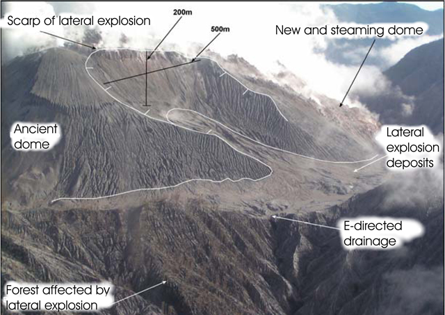 |
Figure 17. Scar of the lateral explosion taken at Chaitén on 31 July 2008 looking at the dome's E side. This view also contains multiple labels detailing the scene. Taken from SERNAGEOMIN (2008a). |
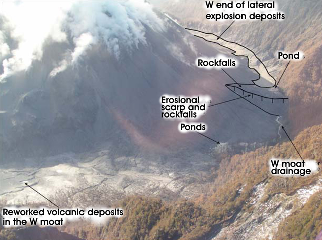 |
Figure 18. Vista of Chaitén's S moat as seen 31 July 2008 from the NE. Taken from OVDASSERNAGEOMIN (2008a). |
Observations during August-November 2008. On 1 August, a N-facing camera situated ~1 km SE of town at the Chaitén airfield showed an active eruption plume in the morning, but weather obstructed the plume in the afternoon. This is one of two such web cameras at that airfield in a national system supported by the Chilean civil aviation agency DGAC. The other web camera shows the town of Chaitén (for more information see IFIS, 2011, in References below).
Seismicity decreased beginning in August and remained relatively low and variable through mid-September 2008. Hybrid earthquakes dominated, and, after 20 September, they increased in number and magnitude. SERNAGEOMIN interpreted seismicity during this time within the system as associated with movements of magmatic fluids and rock rupture. In late September, a seismic station was reinstalled in the volcano's N sector (previously sited at Auchemó, on an island 8 km SSW of the town of Chaitén). The new location was chosen in hopes that it would enable seismologists to better assess the volcano's seismic signals.
Although visual observations revealed comparative quiet during 23-25 September with weak plumes of mainly steam to 1.5-km altitude, the intensity of activity rose on the 27 and 28 September, when a series of columns emitted in separate puffs reached to 3- and sometimes 4-km altitude. The plumes were conspicuous from the settlements of Chaitén and Queilen and contained steam and fine ash.
On 30 September, the new dome had grown, but it lacked both any new scars (like the one seen on 31 July) and signs of further collapse at the 31 July scar. Small lakes remained on the N moat (arrow at left, figure 19). Portions of the older dome were still exposed (arrow at right, figure 19).
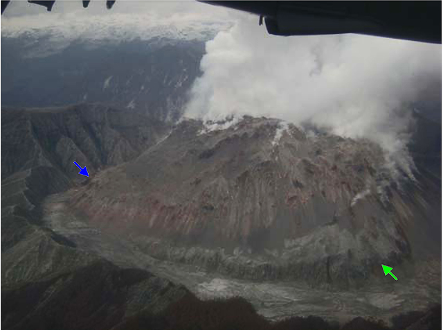 |
Figure 19. Aerial photo of the W portion of Chaitén's dome taken 30 September 2008 (from the E; arrows discussed in text). The upper dome gave off steam over a wide area. Taken from OVDAS-SERNAGEOMIN (2008b). |
An overflight occurred on 30 September, thanks to a Presidential Delegation, during which the emissions remained similar to those previously described. Observers found it hard to define a single vent area for the emissions, although it appeared that abundant vapor escaped in the N dome area (figure 19).
Observers also commented that the scar on the E dome had changed morphology due to erosion. A photo documented that, by 30 September, new dome growth was sufficient in the NE sector to have reached the NE wall. By this time, the report authors noted, the growing dome's height had exceeded that of the caldera's topographic margin (the summit, 1,112 m elevation, a point on the S rim).
The number of hybrid earthquakes increased beginning on 20 September through early October. Beginning on 4 October, the number of earthquakes over M 3.0 decreased, a decline interpreted as related to slowed dome growth. Seismicity continued to decrease through mid-October, and was concentrated mainly in the volcano's S sector. Volcano-tectonic earthquakes did not exceed 3 per day, with magnitudes less than 1.5. Epicenters plotted on a map for 14-16 November scattered along a broad ~3-km-long line trending tangent to the ESE rim of the caldera, with several on the SE dome. Their focal depths were 0.5-3 km.
A miniDoas (a portable spectrometer based largely on differential optical absorption, Nadeau and Williams-Jones, 2008) was used for ground-based transects of the plume on 15 October 2008 to assess SO2 fluxes. After several transects along a N65°W path and wind estimates of 5 m/s (from the Chilean Meteorological Directorate), the resulting flux estimate was 190 metric tons per day.
On 29 October, activity at Chaitén increased, characterized by several explosions that darkened the plume and caused it to rise from ~1.6 km to ~3.1 km. SERNAGEOMIN reported that variations in seismicity remained similar to patterns detected during the previous weeks.
On a 30 October flight, scientists observed a landslide that had originated from the active lava dome. The next day, observers described a plume emitted from multiple areas that rose to an altitude of 2.1 km. The white component of the plume (steam and gas) emitted mainly from the center and S portions of the dome. Vents on the dome's N and NE areas produced a gray plume.
An ONEMI-SERNAGEOMIN report (2008d) covered the date range 31 October-7 November 2008. Owing to bad weather, only on 2 November did observers or cameras in the town of Chatén manage to obtain a reasonable view of the volcano (figure 20). That day, they also saw an appreciable white column that appeared to be predominantly steam, similar to many of the plumes of recent months. The plume blew E, and its top reached ~2 km above the dome.
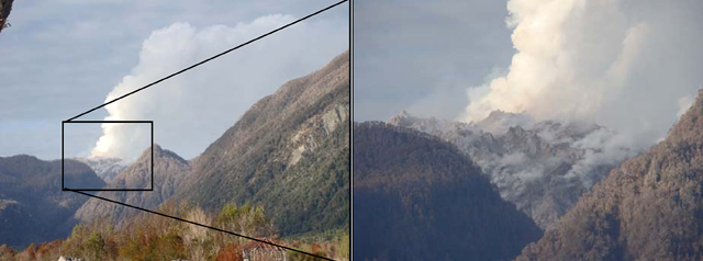 |
Figure 20. Chaitén as seen on 2 November 2008 from the town of the same name (~10 km SW). The photo on the right zooms in on dome in the framed area. Authors described the dome as "constantly growing." Taken from ONEMI-SERNAGEOMIN (2008d). |
On 4 November, ONEMI-SERNAGEOMIN reported that a recent overflight confirmed the presence of a second new lava dome. The new dome grew in the NE part of the first dome that started to form in May 2008 and had a diameter of ~300 m and a height of ~150 m. Spines protruded from the top. Seismicity was concentrated underneath the dome.
Seismicity during 31 October-7 November 2008. Elevated seismicity prevailed during the first week of November. Hybrid earthquakes dominated, averaging 2-5 events per hour. Those over M 3 occurred 1-2 times per hour. They typically had long, low-frequency (1 Hz) codas and focal depths of 0.5-2 km at points below and alongside the caldera.
Volcano-tectonic earthquakes were predominantly of low magnitude (under M 1). A larger event, M 2.2, occurred on 5 November; this was the first event of this type and magnitude in over a month. It was located 2 km W of the caldera margin at 7 km below the surface. The focus was close to, and possibly related to, a major structural lineament that trends NE across the Chaitén substructure at depths below 5 km.
Regarding the town of Chaitén. Heavy rains struck the region on 3 November, and, by 5 November, flooding had inundated parts of the town on the S banks of the Chaitén (Blanco) River (figure 21). One of the drainages with headwaters in the caldera feed into this river, and the moving water carried great quantities of volcanic material downstream. Lahars followed the river, leaving abundant sediments along their path, and they reached the sea at the river's mouth.
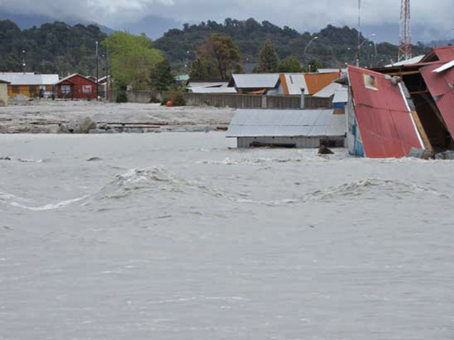 |
Figure 21. The sediment-charged Chaitén river seen in flood on 5 November 2008 looking towards the S side of the town of Chaitén. At distance appear intact portions of the town on higher ground. The river passes E and S of the town and then enters the sea at Chaitén bay on the Corcorvado gulf (see figure 13 in BGVN 33:06 and maps in various issues). Extensive tidal areas lie SE of the town. Taken from ONEMISERNAGEOMIN (2008d). |
According to ONEMI-SERNAGEOMIN, during dry conditions, both wind and vehicular traffic in Chaitén kicked up fine ash, which remained suspended in the atmosphere. This ash had obliged the town's few remaining inhabitants to don dust masks. The requisite masks needed to filter out material down to 5 microns in diameter.
References. IFIS (Internet Flight Information Service), 2011, Location map showing camera at Chaitén airfield (URL: http://www.aipchile.cl/aerodromo/ubicacion/designador/SCTN; Images of the volcano, http://www.aipchile.cl/camara/show/id/14); Images of the river and town, http://www.aipchile.cl/camara/show/id/15).
Carn, S. A., Pallister, J. S., Lara, L., Ewert, J. W., Watt, S., Prata, A. J., Thomas, R. J., and Villarosa, G., 2009, The Unexpected Awakening of Chaitén Volcano, Chile, Eos, Transactions, American Geophysical Union, Vol. 90, No. 24, 16 JUNE 2009, pp. 205-206.
Nadeau, P. A. and Williams-Jones, G., 2008, Beyond COSPECRecent advances in SO2 monitoring technology. In: Williams-Jones, G., Stix, J. & Hickson, C. (eds.) The COSPEC Cookbook: Making SO2 Measurements at Active Volcanoes. IAVCEI, Methods in Volcanology, 1, 219-233.
OVDAS-SERNAGEOMIN, 2008a, Erupción del volcán Chaitén, Cuadragésimo Quinto Informe Técnico, 31 de julio al 01 de agosto de 2008, 4 pp., Issued 1 August 2008 (in Spanish) [file name: Informe_45_Chaitén_al_01.08.08[1].pdf].
OVDAS-SERNAGEOMIN, 2008b, Erupción del volcán Chaitén, Informe Técnico No. 55, 23-30 de septiembre de 2008, 4 pp., (Issued 30 September 2008 (in Spanish) [file name: Informe_55_Chaitén_al_30.09.08[1].pdf].
OVDAS-SERNAGEOMIN, 2008c, Erupción del volcán Chaitén, Informe Técnico No. 58, 14-20 de Septiembre de 2008, 3 pp. Issued 20 October 2008 (in Spanish), [file name: Informe_58_Chaitén_al_20.10.08.pdf].
OVDAS-SERNAGEOMIN, 2008d, Erupción del volcán Chaitén, Informe Técnico No. 60, 31 de octubre-07 de noviembre de 2008; 3 pp., Issued 8 November 2008 (in Spanish), [file name: Informe_60_Chaitén_al_07.11.08.pdf].
Geological Summary. Chaitén is a small caldera (~3 km in diameter) located 10 km NE of the town of Chaitén on the Gulf of Corcovado. Multiple explosive eruptions throughout the Holocene have been identified. A rhyolitic obsidian lava dome occupies much of the caldera floor. Obsidian cobbles from this dome found in the Blanco River are the source of artifacts from archaeological sites along the Pacific coast as far as 400 km from the volcano to the N and S. The caldera is breached on the SW side by a river that drains to the bay of Chaitén. The first recorded eruption, beginning in 2008, produced major rhyolitic explosive activity and building a new dome and tephra cone on the older rhyolite dome.
Information Contacts: Oficina Nacional de Emergencia - Ministerio del Interior (ONEMI), Beaucheff 1637 / 1671, Santiago, Chile (URL: http://www.onemi.cl/); Observatorio Volcanológico de los Andes del Sur-Servico Nacional de Geologia y Mineria (OVDAS-SERNAGEOMIN), Avda Sta María No. 0104, Santiago, Chile (URL: http://www.sernageomin.cl/); Buenos Aires Volcanic Ash Advisory Center (VAAC), Servicio Meteorológico Nacional-Fuerza Aérea Argentina, 25 de mayo 658, Buenos Aires, Argentina (URL: http://www.smn.gov.ar/vaac/buenosaires/productos.php).