Report on Kizimen (Russia) — February 2011
Bulletin of the Global Volcanism Network, vol. 36, no. 1 (February 2011)
Managing Editor: Richard Wunderman.
Kizimen (Russia) Powerful fissure eruption in November 2010 ends ~82-year repose
Please cite this report as:
Global Volcanism Program, 2011. Report on Kizimen (Russia) (Wunderman, R., ed.). Bulletin of the Global Volcanism Network, 36:1. Smithsonian Institution. https://doi.org/10.5479/si.GVP.BGVN201102-300230
Kizimen
Russia
55.131°N, 160.32°E; summit elev. 2334 m
All times are local (unless otherwise noted)
Eruption began here during mid-November 2010, the first since 1927-1928 (Brown and other, 2010). Ash plumes rose to ~10 km and were visible in satellite imagery as they traveled hundreds of kilometers during November 2010 through at least late February 2011. Our previous Bulletin (BGVN 35:02) reported that the number of earthquakes at Kizimen had increased substantially beginning in July 2009 (up to 120 earthquakes per day) through early April 2010 and that fumarolic temperatures increased in August. This report discusses activity since early April 2010.
After early April 2010, seismicity at Kizimen entered a quiescent phase until the Kamchatkan Volcanic Eruption Response Team (KVERT) reported increased seismic activity on 20 August and particularly during early November 2010. Based on information from a tourist center 10 km from Kizimen, KVERT noted that on 11 November 2010, strong gas-and-steam emissions resulted in a plume, possibly containing some ash, that rose to an altitude of 4 km.
According to the Kamchatkan Branch of Geophysical Survey (KG GS RAS), seismicity of the volcano was above background levels all week, and an M 4 earthquake occurred on 16 November 2010. According to information from the Yelizovo Airport (UHPP), the Tokyo VAAC reported that on 17 November an ash plume from Kizimen rose to an altitude of 3 km and drifted NE. KVERT noted the lack of satellite data about ash near Kizimen. The Level of Aviation Color Code remained at Green (on a scale that goes from low to high using these terms: Green, Yellow, Orange, and Red).
Seismic activity was above background levels during 19 November to 24 December 2010. On 20 November, volcanologists flying around Kizimen by helicopter observed several new fumaroles at the summit and SW flank. A small amount of "dust" covered the SW flank, possibly ash from the new fumaroles. Activity at the established old fumarole "Revuschaya" on the volcano's NE flank decreased. No thermal anomaly was noted from satellite images. The Level of Aviation Color Code was raised to Yellow.
On 9 December 2010, seismicity increased significantly and the Aviation Color Code level was raised to Orange. That same day, the Tokyo VAAC reported that, according to KB GS RAS, an explosion produced a plume that rose to an altitude of 2.7 km and drifted N. Ash was not identified in satellite images. A bright thermal anomaly was observed in satellite imagery the next day.
The beginning of the eruption Kizimen was captured in in a photo made by Don Page on 10 December from a commercial flight. The eruption start from long fissure on the SE slope (figure 5).
 |
Figure 5. Photo taken on 10 December 2010 at 0314 UTC (1414 local Kamchatka time; from Seat 36K of Air Canada Flight 063 from Vancouver, Canada, to Incheon-Seoul, Korea). A dark, angled (non-vertical) plume rises from the along the length of an elongate fissure network on the SE slope. [Photo: 981x656 pixels, with a Nikon D80 digital camera and an AF-S Nikkor 18-200 mm zoom lens (probably set at 200 mm).] Photo by Don Nelson Page (University of Alberta). |
[On 13 December 2010 (UTC) an explosive eruption generated ash plumes that rose to altitudes of 3-3.5 km and drifted NW. Based on information from KEMSD and analysis of satellite imagery, the Tokyo VAAC reported that an ash plume rose to an altitude of 10 km and drifted N. KVERT noted that lightning in the ash plumes was observed. The Aviation Color Code was raised to Red. Ash deposits in Kozyrevsk and Tigil, 110 and 308 km NW, respectively, were 5 mm thick. Later that day seismic activity decreased; the Aviation Color Code was lowered to Orange.]
Kronotsky National Park staff, residing at Ipuin (~16 km WSW), noted that the water level in Levaya Schapina river rose 60 cm after the explosions and remained elevated for the next two days. The water was also very muddy. During 14-24 December seismicity remained above background and a thermal anomaly over the lava dome was detected in satellite imagery.
KVERT noted that during 17-24 December 2010 the number of shallow seismic earthquakes increased from 110 events on 17 December to 304 events on 22 December. Volcanic tremor was detected on 23 December. During 26-28 December, seismicity also increased and there were possible small ash explosions and hot avalanches. A thermal anomaly over the lava dome was again seen in satellite imagery. On 27 December seismic analysis indicated that ash plumes that day possibly rose to altitudes of 3.5-4.5 km. Satellite imagery showed ash plumes drifting 140 km W at an altitude of 4 km. On 28 December, based on a Yelizovo Airport (UHPP) notice, the Tokyo VAAC reported an ash plume drifting W at an altitude of 3.7 km. The Aviation Color Code was raised to Red.
A thermal anomaly over Kizimen's lava dome was again observed in satellite imagery during 29 December 2010-1 January 2011 and an explosive eruption that began on 13 December continued. On 31 December seismicity increased and volcanic tremor was detected. Explosions occurred sporadically for a period of about 20 minutes. Ash plumes detected in satellite imagery rose to an altitude of 8 km and drifted SW. Ashfall at least 1 mm thick occurred in multiple areas 225-275 km SSW, including Petropavlovsk-Kamchatsky, Yelizovo, Paratunka, and Nalychevo. Ash plumes at an altitude of 4 km drifted 480-500 km SW; ash continued to accumulate in some areas.
Seismic data indicated increased activity on 3 January. Based on analysis of satellite imagery, the Tokyo VAAC reported that possible eruptions during 2-4 January produced plumes that rose to an altitude of 3-4.6 km and drifted S, E, and NE. Subsequent images on those same days showed ash emissions continuing, then dissipating. During 4-7 January seismicity remained high and variable and volcanic tremor continued. A thermal anomaly over the volcano was observed in satellite imagery. Explosions continued through 7 January 2011 producing ash plumes mostly below altitudes of 6-8 km as reported by pilots or observed in satellite imagery. These drifted more than 200 km SE. A large and bright thermal anomaly was observed in satellite imagery.
A pattern of high seismicity and ash emissions was noted during early January 2011. On 5 January ash plumes drifted more than 500 km ENE. Ashfall was reported on the Komandorsky Islands, 350-500 km E (figure 6).
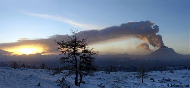 |
Figure 6. An ash plume rising from Kizimen and blowing to the ENE on 5 January 2011. Courtesy of A. Lobashevsky. |
The Tokyo VAAC reported that ash continued to be observed in satellite imagery on 5 January. According to information from KVERT and analyses of satellite imagery, a possible eruption on 6 January produced a plume that rose to an altitude of 3.7 km and drifted E. Subsequent satellite images that same day showed continuing ash emissions. Ash plumes drifted NW on 9 January, and drifted NW again on 11 January 2011, at an altitude of 2.7 km.
KVERT reported that during 7-13 January 2011 they saw both a thermal anomaly over Kizimen in satellite imagery and pyroclastic flow deposits on the E flank. Seismicity recorded during 6-7 and 12 January was high but variable, and many shallow volcanic earthquakes as well as volcanic tremor continued to be detected. Ash plumes that rose to altitudes of 6-8 km during 5-13 January were seen drifting multiple directions, and appeared in satellite imagery to be drifting more than 275 km W and NW. On 12 January ashfall was reported in the villages of Anavgai and Esso, 140 km NW. Seismic data during 14-15 January suggested that ash plumes rose to altitudes of 4-5 km. Satellite images showed a bright thermal anomaly over the volcano and ash plumes drifting more than 180 km W on 15 January 2011. The Aviation Color Code level was lowered to Orange.
From 14 January through 1 February, KVERT reported that seismicity from Kizimen was high but variable, and many shallow volcanic earthquakes as well as volcanic tremor continued to be detected. Seismic data analyses suggested that ash plumes possibly rose to an altitude no higher than 6 km. Satellite images showed a daily bright thermal anomaly over the volcano, and ash plumes that drifted more than 200 km W during 15-16 and 20 January. Based on satellite data, the Tokyo VAAC also reported that during 23-25 January eruptions produced plumes that rose to altitudes of 4.9-10.1 km. Based on analyses of satellite imagery, the Tokyo VAAC reported that a possible eruption on 29 January produced a plume that rose to an altitude of 3.7 km and drifted SW. Photo and satellite images taken during late January through late February showed continuing ash emissions (figures 7 and 8).
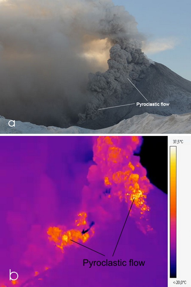 |
Figure 7. Two images of Kizimen taken on 26 January 2011. On the left photo (a), a dark pyroclastic flow rushes down the slopes of the volcano. Photo by Igor Shpilenok. On the right (b), a thermal infra-red (IR) image taken of a pyroclastic flow during an explosion (IR scale temperature appears at right). The pyroclastic flow originated from the summit of the lava dome and swept downward. (The infrared image shows radiated energy as areas of bright glow.) During this eruptive stage a pyroclastic surge spread out over the slopes. IR image by V. Droznin, S. Chirkov, and I. Dubrovskaya (IVS RAS). |
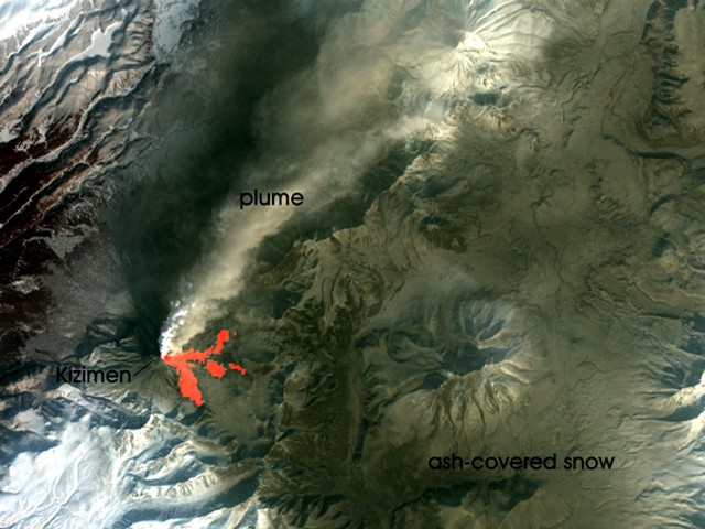 |
Figure 8. This satellite image taken on 25 February 2011 shows a vigorous ash-laden plume extending from Kizimen at an altitude of ~3 km, drifting towards the NE, and visible for more than 170 km. The white portion of the plume is likely rich in steam, while the tan plume is primarily ash. The ground E of Kizimen is coated in newly fallen ash not yet covered by fresh snow. To the S of the summit are several dark streaks. These are probably traces of pyroclastic flows. Thermal anomalies (red in colored versions of this Bulletin) show the presence of recent hot block-and-ash flows from summit dome collapses. The image was acquired by the Advanced Spaceborne Thermal Emission and Reflection Radiometer (ASTER) aboard the Terra satellite. Courtesy of NASA/GSFC/METI/ERSDAC/JAROS. |
Reference: Browne B., Izbekov, P., Eichelberger, J., and Churikova, T., 2010, Pre-eruptive storage conditions of the Holocene dacite erupted from Kizimen Volcano, Kamchatka: International Geology Review, v. 52, Issue 1 January 2010, p. 95-110.
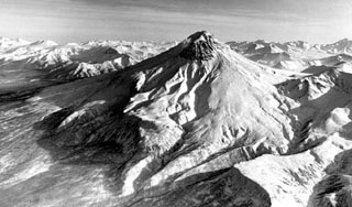
Geological Summary. Kizimen is an isolated, conical stratovolcano that is morphologically similar to St. Helens prior to its 1980 eruption. The summit consists of overlapping lava domes, and blocky lava flows descend the flanks of the volcano, which is the westernmost of a volcanic chain north of Kronotsky volcano. The 2334-m-high edifice was formed during four eruptive cycles beginning about 12,000 years ago and lasting 2000-3500 years. The largest eruptions took place about 10,000 and 8300-8400 years ago, and three periods of long-term lava dome growth have occurred. The latest eruptive cycle began about 3000 years ago with a large explosion and was followed by intermittent lava dome growth lasting about 1000 years. An explosive eruption about 1100 years ago produced a lateral blast and created a 1.0 x 0.7 km wide crater breached to the NE, inside which a small lava dome (the fourth at Kizimen) has grown. Prior to 2010, only a single explosive eruption, during 1927-28, had been recorded in historical time.
Information Contacts: Kamchatka Volcanic Eruptions Response Team (KVERT), Institute of Volcanology and Seismology Russian Academy of Sciences, Far East Division, 9 Piip Blvd., Petropavlovsk-Kamchatsky, 683006, Russia (URL: http://www.kscnet.ru/ivs/); Kamchatka Branch of the Geophysical Service of the Russian Academy of Sciences (KB GS RAS), Piip Ave. 9, Petropavlovsk-Kamchatsky, 683006, Russia (URL: http://www.kscnet.ru/ivs/); Sergey Senukov, Russia (URL: http://www.emsd.ru/) Valery Droznin and Sergey Chirkov, Institute of Volcanology and Seismology Russian Academy of Sciences, Far Eastern Branch, 9 Piip Boulevard, Petropavlovsk-Kamchatsky, 683006, Russia; A. Lobashevsky (URL: http://www.photokamchatka.ru/); I. Shpilenok (URL: http://shpilenok.livejournal.com/44922.html); NASA Earth Observatory (URL: http://earthobservatory.nasa.gov/); Don Nelson Page, Theoretical Physics Institute, 412 Physics Lab., University of Alberta, Edmonton, Alberta T6G 2J1, Canada.