Report on Poas (Costa Rica) — April 2011
Bulletin of the Global Volcanism Network, vol. 36, no. 4 (April 2011)
Managing Editor: Richard Wunderman.
Edited by Jen Fela.
Poas (Costa Rica) Photos of phreatic eruptions from acid lake; surrounding vegetation damaged by gases
Please cite this report as:
Global Volcanism Program, 2011. Report on Poas (Costa Rica) (Fela, J., and Wunderman, R., eds.). Bulletin of the Global Volcanism Network, 36:4. Smithsonian Institution. https://doi.org/10.5479/si.GVP.BGVN201104-345040
Poas
Costa Rica
10.2°N, 84.233°W; summit elev. 2697 m
All times are local (unless otherwise noted)
Occasional, typically minor phreatic eruptions occurred at Poás through at least early February 2011 (BGVN 35:12). They emerged from the active crater lake, Lago Caliente. The Observatorio Vulcanologico y Sismologico de Costa Rica-Universidad Nacional (OVSICORI-UNA) illuminated intervals of phreatic eruptions and relations on the chemistry of Lago Caliente's waters over a period of more than 30 years (figure 94). This report includes photos of phreatic eruptions in 2009, 2010, and early 2011, and reviews events through March 2011.
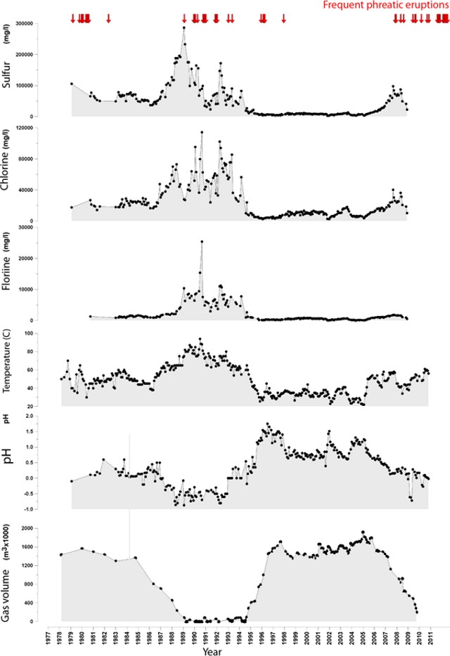 |
Figure 94. Plots of the sulfur, chlorine, and fluorine concentrations, as well as the temperature, pH, and gas volumes in the Lago Caliente waters at Poás, with respect to time. The data on the time axis extends from early 1978 to late 2009. Arrows along the top indicate periods with frequent phreatic eruptions. Notice the low pH, often well below pH 1.5. Courtesy of OVSICORI-UNA. |
Volcanic gases and associated condensate and rainfall led to increasing areal extent and degree of damage to vegetation in nearby areas. In studying the Lago Caliente's waters, Martinez and others (2011) found in solution a variety of oxo-anions of sulfur called polythionates (SnO6-2, where n can be 20 or larger), which they found to vary in concentration from undetectable to 8,000 mg/L. They considered polythionates to be "highly relevant for monitoring purposes at Poás, in particular because they may signal impending phreatic eruptions."
More on the 25 December 2009 phreatic eruption. A previous report (BGVN 35:12) discussed a phreatic eruption on 25 December 2009 but some further comments are worth adding. As previously noted (BGVN 35:12), "Steam and lake water mixed with sediment and blocks were ejected 550-600 m above Laguna Caliente and fell in the vicinity of the lake, within the crater." No mention was previously made of a 24 December 2009 phreatic eruption discussed by OVSICORI-UNA. It took place in the morning at 0808 and all erupted material fell back in the crater.
Photos taken on 25 December 2009 and recently posted on the Picasa website have come to our attention. The four photos on figure 95 come from a set of nine taken from the S rim. The earliest of the set depict a very tranquil lake with steaming at or near the dome (not shown here). The next photo, taken 129 seconds after that tranquil scene, portrays the advancing eruption (figure 95a). The subsequent two photos (figure 95b and c) captured the interval closest to the peak of the eruptive vigor.
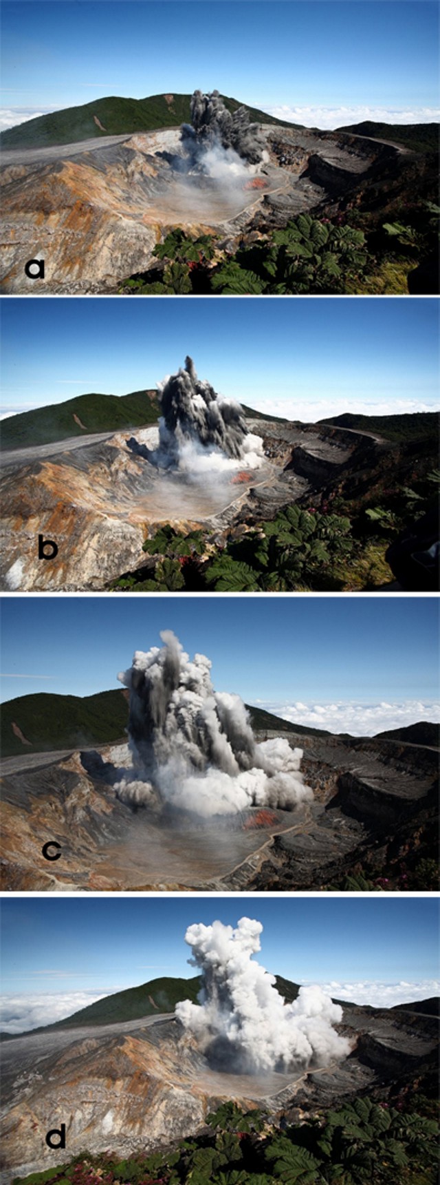 |
Figure 95. Four sequential photos taken looking N at Poás of a phreatic eruption from the center of Lago Caliente on 25 December 2009. The time intervals between the four photos was as follows: photos (a) to (b), 5 sec; photos (b) to (c), 5 sec; and photos (c) to (d), 11 sec. Photo descriptions below: (a) The earliest available photo of the eruption cloud, which, based on the next photo in this set, was clearly still emerging energetically. It advanced with the leading portions of the plume chiefly dark. At the plume's base, white steam clouds mask the lake. (b and c) The shots taken closest to the maximum point of the eruption's thrust phase, with dark material still conspicuous. White tufts expanded and began to cap most of the advancing jets. The clouds engulfing the base of the plume now contain more discolored zones. (d) As the plume evolves and the vigorous exhalative part of the eruption ends or wanes, a steam-rich cloud envelops the eruption cloud. Note the gray-colored rain falling out of the plume. Taken from Cindy and JM's Gallery (undated) on the Picasa photo sharing website (see References and Information Contacts below). |
An exact assessment of the photos is complicated by several factors. There were shifts in the focal length of the lens (documented in camera metadata found on the website). Also, in detail, the camera's time record indicated 0252 hrs, clearly incorrect for this daylight scene. That problem is reconciled by a photo featured in the OVSICORI-UNA report, which showed a plume photo by another photographer at a stage nearly identical to figure 95b and the text indicated the eruption occurred at 0952 hrs local time.
An email response from Cindy Doire provided these comments about witnessing the phreatic eruption.
"We arrived at the volcano early in the morning. We were one of the first to arrive that day. Our group and a few other tourists were looking at it and NOTHING was happening. The people finished looking and started leaving that spot. It was just about 4 of us still there, when suddenly the volcano started to erupt. There was NO warning at all. Even the rangers were surprised. At the beginning, white steam (gas?) shot up, then black rock and dirt started exploding out. I believe that everything that shot up, fell back into the crater . . . the gas could be smelled and was strong . . .."
In an email to GVP regarding the 25 December 2009 eruption, Eliecer Duarte commented: "It seems that this [25 December 2009] eruption opened a more permanent vent at the bottom of the lake. Since that event the frequency of phreatic ones increased and remained like this for [a] year and a half. We still have dozens of smaller ones daily.
More on crater degassing. Field visits during 2010 and 2011 allowed scientists to see the expanding effects of Poás volcanic gases on vegetation (figures 96 and 97). Dry conditions resulted in winds carrying the gases considerable distances from the volcano. The area most affected was an elongate zone downwind of the active crater and extending ~4 km SW. Figure 97 portrays transitional zones with intermediate effects.
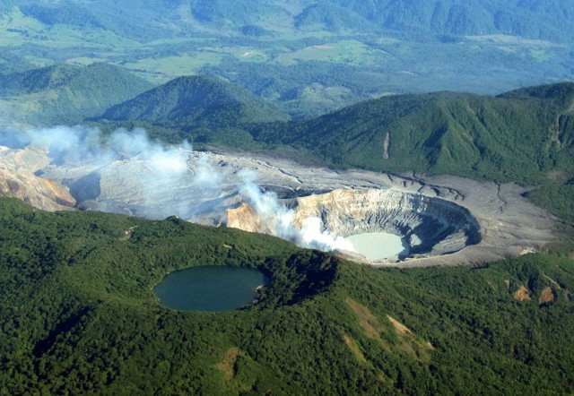 |
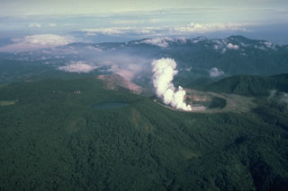
Figure 96. A commercial airline pilot and amateur photographer took this and other photos of Poás on 28 April 2010. The active crater and its discolored lake (Lago Caliente) reside at the right-hand side of this shot. It is part of an elongate zone of barren rock stretching ~4 km across the otherwise lushly vegetated landscape. As is typical, the plume's orientation on this day lies directly over the barren zone. From "Len" (undated), (see Reference below). |
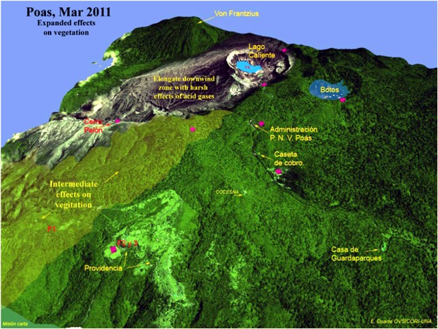 |
Figure 97. Oblique view highlighting the area to the S of Poás (note volcano's crater lakes, including the active "Lago Caliente") On color versions of this figure, the pink rhombuses show sites for collecting acid rain. Providencia is shown in the lower left. The crater lake at upper right, "Botos" is ~0.5 km across in the long direction but the scale on this image varies with distance towards the foreground. Courtesy E. Duarte, OVSICORI-UNA. |
Starting just beyond the elongate zone of harsh effects, the areas of discolored vegetation had increased impact and areal extent. One such impacted area was a nature preserve called Providencia, which is seen in figure 97 to the left of Poás. Farther from the volcano lies Cerro Pelón (2.5 km distance and direction SW of the crater) , which also showed the effects of chemical burning from volcanic gases (figure 97).
In the past, activity centers have migrated within the crater. OVSICORI-UNA reported that, for at least the past year (ending March 2011), the points of degassing have been concentrated in the hot crater lake and dome (figure 98). The emanating steam and gases, often carried by wind, have affected areas up to several hundred meters around the crater (figures 96-98).
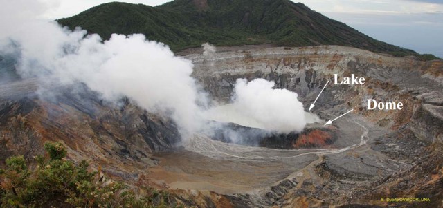 |
Figure 98. The active crater at Poás, showing pronounced steam release both from fractures in the dome as well as from the lake's surface. Conditions like this (with more or less steam) often prevailed in recent times (including just a few seconds prior to the eruption sequence shown in figure 95). The crater lake (Lago Caliente) rests behind (N of) the dome and steam clouds. Courtesy E. Duarte, OVSICORI-UNA. |
OVSICORI-UNA reported that through at least March 2011 small phreatic eruptions occurred daily at Lago Caliente. These eruptions sometimes only reached the lake's surface, but at other times reached a few meters above the lake, and occasionally, tens of meters above the lake. The majority of the erupted sediments fell back into the lake. The fine sediments sometimes remained suspended in the lake water and caused its gray color. The majority of eruptions occurred in the central part of the crater, with a few originating slightly more to the N or S of the center. Because of the phreatic activity and high temperature of the lake (57°C), strong evaporation occurred and plumes traveled long distances in the wind (figure 99).
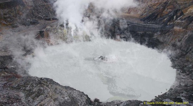 |
Figure 99. At Poás, a phreatic eruption at Lago Caliente reaching several meters high, in a manner typical of daily activity during recent months. View from the active crater's N side (opposite the viewpoint). Photo taken sometime in January 2011. Courtesy E. Duarte, OVSICORI-UNA. |
A comparison of vegetation in the area between Cerro Pelón and Providencia (designated "F1" in figure 97) made during August 2010 to January 2011 found that most plant species were resistant at certain levels of acidification. However, when their tolerance thresholds were reached, the affected species decayed quickly and were sometimes unable to recover. Certain species, including eucalyptus, pine, alder, and cypress, were particularly sensitive to the volcanic gases. Minor effects from gases were observed on Cypress trees as far as 9 km SW of the emission source. OVSICORI-UNA reports contained several photos showing more details on the effects of acidic gases on vegetation. One of their later reports, from April 2011, discussed ongoing phreatic eruptions and dome temperature of 560°C.
References. Cindy and JM's Gallery, undated, "Poas volcano eruption, December 25th, 2009" [9 photos] Picassa (URL: https://picasaweb.google.com/cjmdoire); [includes camera-related metadata].
Len (Barfbag), undated, "Wednesday, April 28, 2010, Mt Poas, Costa Rica" ; in Viewsfrom the left seat, A look at the airline world ... ride along in the cockpit (URL: http://viewsfromtheleftseat.blogspot.com/2010/04/mt-poas-costa-rica.html)
Martínez, M., van Bergen, M.J., Fernández, E., and Takano, B., 2011, Polythionates monitoring at the acid crater lake of Poás Volcano, IAVCEI-COMMISSION OF VOLCANIC LAKES, CVL7 Workshop, Costa Rica, 10-19 March 2010, Online Abstracts volume (May 2011), p. 12 (URL: http://www.ulb.ac.be/sciences/cvl/)
Geological Summary. The broad vegetated edifice of Poás, one of the most active volcanoes of Costa Rica, contains three craters along a N-S line. The frequently visited multi-hued summit crater lakes of the basaltic-to-dacitic volcano are easily accessible by vehicle from the nearby capital city of San José. A N-S-trending fissure cutting the complex stratovolcano extends to the lower N flank, where it has produced the Congo stratovolcano and several lake-filled maars. The southernmost of the two summit crater lakes, Botos, last erupted about 7,500 years ago. The more prominent geothermally heated northern lake, Laguna Caliente, is one of the world's most acidic natural lakes, with a pH of near zero. It has been the site of frequent phreatic and phreatomagmatic eruptions since an eruption was reported in 1828. Eruptions often include geyser-like ejections of crater-lake water.
Information Contacts: E. Duarte and E. Fernández, Observatorio Vulcanologico Sismologica de Costa Rica-Universidad Nacional (OVSICORI-UNA), Apartado 86-3000, Heredia, Costa Rica (URL: http://www.ovsicori.una.ac.cr/); Cindy Doire (address withheld by request).