Report on Merapi (Indonesia) — May 2011

Bulletin of the Global Volcanism Network, vol. 36, no. 5 (May 2011)
Managing Editor: Richard Wunderman.
Edited by Julie A. Herrick.
Merapi (Indonesia) Recovery; intermittent activity; damaging lahars
Please cite this report as:
Global Volcanism Program, 2011. Report on Merapi (Indonesia) (Herrick, J.A., and Wunderman, R., eds.). Bulletin of the Global Volcanism Network, 36:5. Smithsonian Institution. https://doi.org/10.5479/si.GVP.BGVN201105-263250
Merapi
Indonesia
7.54°S, 110.446°E; summit elev. 2910 m
All times are local (unless otherwise noted)
A VEI 4 (Volcanic Explosivity Index) eruption began at Merapi volcano on 26 October 2010. Within the last 100 years, this volcano had not produced such large-magnitude explosions (Surono and others, in review; Andreastuti and others, 2011). The eruption and secondary events affected areas in all directions around the volcano; pyroclastic flows reached 4 km to the N, 11.5 km to the W, 7 km to the E, and ~15 km to the S, and explosive bombs reached 4 km from the summit in all directions (Jousset, 2010). These events included explosive central vent eruptions that caused significant changes in the summit morphology (figure 48) and according to Act Forum Indonesia, triggered evacuations of communities within a 20 km radius of the summit. In BGVN 36:1/2 we reported on preliminary damage assessments that included significant fatalities and damaged infrastructure.
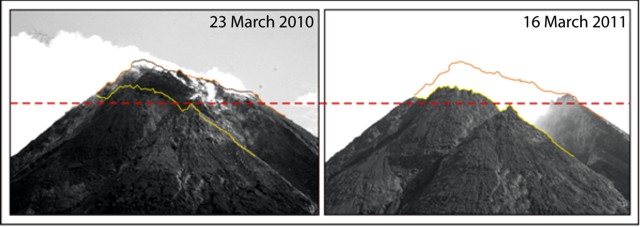 |
Figure 48. A photo comparison of Merapi's morphological changes on 23 March 2010 and 16 March 2011. Viewed from the S flank, these photos focus on the summit dome. Non-juvenile material was excavated during two episodes of explosive activity. During 26-29 October ~1.4 x 10⁶ m3 was excavated from the crater and from 4-5 November ~10 x 106 m3 was removed (Surono and others, in review). Photo courtesy of the Volcano Technical Research Center (Balai Penyelidikan dan Pengembangan Teknologi Kegunungapian, "BPPK") from their report covering 14-20 March 2011. |
The explosive events of 2010 represent a break in Merapi's iconic style of activity (Surono and others, in review). "Merapian" is a term often assigned to volcanic events characterized by hot pyroclastic block flows generated during the collapse of growing viscous lava domes (Schmincke, 2004). Standard eruptive activity at Merapi includes "continuous degassing and extrusion of andesitic lava domes whose collapses generate block avalanches and gravitational pyroclastic flows" (Allard and others, 2011).
At least 17 VEI = 2 events have occurred since the catastrophic 15 April 1872 eruption (Siebert and others, 2010). While explosive activity is characteristic of past behavior, assessments of data from 2010 confirm that the 26 October eruptive sequence did not begin with lava extrusion (typical of past eruptions). Instead, intense explosions initiated activity that lasted for ~5 weeks (Surono and others, in review).
During the Merapi special session at the EGU General Assembly held in April 2011, Andreastuti and others (2011) concluded that "the rate of magma extrusion [during the peak of Merapi's 2010 activity] was as much as 17-to 21-times higher [than] the 2006 eruption and the distance of pyroclastic flows in the same drainage (Gendol River) reached 15 km in 2010 and only 7 km in 2006."
This assessment and others (e.g. Alder and others, 2011) linked the highly explosive eruptions of October-November 2010 to elevated and variable gas emissions.
On 4 December 2010, after 40 days of maintaining the highest alert, the Indonesian Center of Volcanology and Geological Hazard Mitigation (CVGHM) downgraded the hazard Alert Level from 4 to 3 ("Awas," Red Alert to "Siaga," Watch). The Alert Level was reduced again on 19 January 2011 from 3 to 2 (to "Waspada," Advisory). The Alert Level remained at Level 2 into June 2011.
In this report we review the recovery efforts, Merapi's intermittent activity, and the long-term lahar crisis from March to June 2011. We also include a review of intervals of gas geochemistry data recorded prior to the 26 October 2010 disaster that recently became available.
Recovery efforts. Since October 2010, of the ~300,000 people evacuated, 11,000 were still displaced as of January 2011 (Jakarta Post and IRIN). Authorities had set up nine camps within the city of Yogyakarta and ~70 camps were located farther away within Central Java. On 2 May 2011 the head of Badan Nasional Penanggulangan Bencana (BNPB), Indonesia's National Disaster Management Agency, reported: "With almost all the displaced having moved to temporary shelters, our focus now is how to rebuild communities affected by the disaster" (IRIN, 2011).
In May 2011 the Indonesian government sought international aid (including the International Red Cross and United Nations) and international non-governmental organizations were working in Indonesia for relief efforts. The Jakarta Post reported on 12 May 2011 that Australia had agreed to help Indonesia establish a Disaster Relief Center for disaster management training; the location will be in Sentul, West Java and will serve members of the Association of Southeast Asian Nations (ten countries currently belong to ASEAN). BNPB had called upon the World Bank to begin a Risk Transfer scheme, allowing the local government to focus aid specifically on reconstruction programs.
According to reports from the Jakarta Globe in April 2011, the recent disaster and long history of volcanism at Merapi prompted the Indonesian government to implement an extensive recovery plan for the Yogyakarta province. They prioritized the development of spatial planning maps, expansion of the Merapi National Park, large-scale reforestation (approximately 1,300 hectares), and allocation of 1.35 trillion Rupiah ($155 million) to improve housing, infrastructure, social efforts, and economic stimulation plans. New mapping in the province will reassign land-use and designate relocation sites for former residents. In general, residential areas lying within 10 km of the summit will remain off limits (Sayudi and others, 2010). The Jakarta Post noted these maps also highlight where reforestation will occur. Impacts were substantial to Merapi National Park which lost up to 2,800 hectares out of 6,410 hectares of forest due to the recent eruptions. The Volcano Technical Research Center (BPPTK) reassessed zones in the Sleman region, the area hardest hit by volcanic activity, and will release a map indicating hazard zones. "[These maps] will show which areas are safe, unsafe and suitable for habitation," stated Sleman administration spokeswoman Endah Sri Widiastuti (Jakarta Post).
A controversial location within the 10 km exclusion zone is the village of Kinahrejo, the former home of spiritual leader Mbah Maridjan, called the guardian of Merapi. Working with a team of 17 respected community members, he preserved traditional ceremonies and local culture for Merapi residents. Pyroclastic flows covered the village on 26 October 2010, taking the life of the guardian and other inhabitants who did not evacuate.
The new guardian is Mbah Maridjian's son, Asihono (his new name: Mas Lurah Suraksosihono). During Merapi's disastrous eruptions of October and November, Asihono cooperated with the local government and agencies including the Volcanology and Geological Disaster Mitigation Agency (PVMBG) and BPPTK. On 4 April 2011 Sultan Hamengku Buwono X elected Asihono from a group of eight candidates. In an interview with Jakarta Globe on 5 April 2011, the new guardian explained: "I'm not just going to take a cultural approach based on the dreams or guidance from the spirits, but I will also coordinate with the authorities to protect human life and the environment on Mount Merapi and anticipate the fall of victims to future eruptions."
New dome growth. Seismicity was variable and intermittent explosions were observed at Merapi at least every month through June 2011 since the main eruptive events of October and November 2010. This activity kept local residents vigilant and caused some alarm when incandescence suddenly appeared on Merapi's summit on 25 March and 13 April (figure 49). On these two occasions, a bright glow on the crater's E side was recorded on closed circuit television (CCTV).
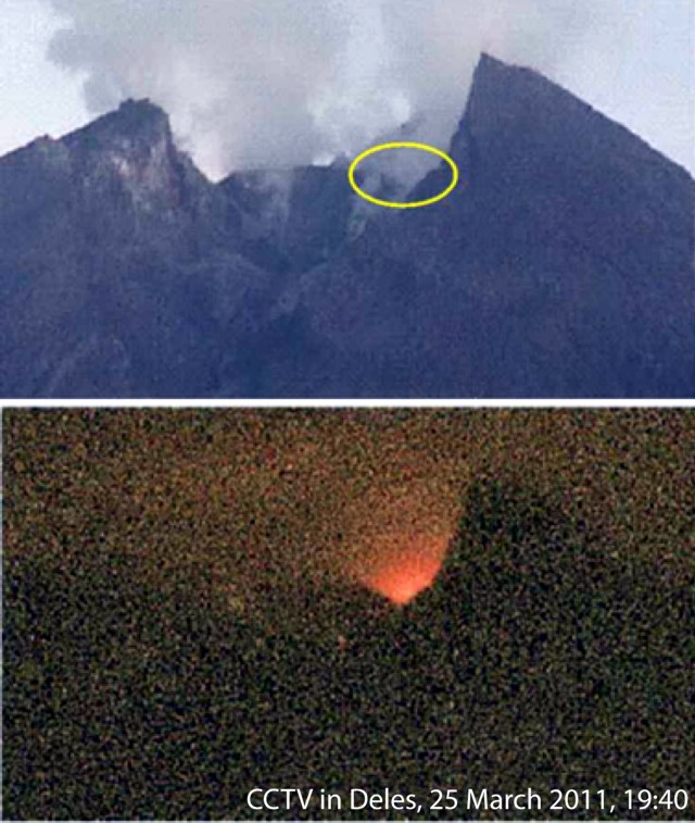 |
Figure 49. Bright incandescence visible on the E side of Merapi's crater was observed at 1940 on 25 March 2011. Courtesy of Volcano Technical Research Center (BPPTK Activity Report 21-27 March 2011). |
The point of incandescence was a location of concentrated degassing. In the aftermath of the eruption in 2010, fumaroles became well established and BPPTK intends to resume gas monitoring. They reported that a new dome was growing in the crater: "The final phase is usually marked by eruption of lava dome growth. However, we won't lower the [alert] status as long as the condition of Merapi is still volatile," reported Subandriyo of BPPTK on 11 April 2011 (Kompas News). Since 19 January 2011, the Alert Level was at 2, Advisory.
Gas monitoring. From ultraviolet correlation spectrometer (COSPEC) measurements, BPPTK reported continuous SO2 emissions for both 1992 through early 2009 (BPPTK, 2011b) and January 2005-January 2010 (figure 50). Other data resulted from sampling with Giggenbach bottles; a method of condensate retrieval requiring evacuated alkaline-solution-filled bottles (Williams-Jones and Rymer, 2000). Gas species such as CO2, SO2, H2S, and HCL were analyzed during June 2003-June 2010 (figure 51).
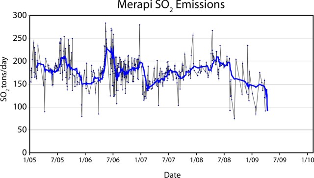 |
Figure 50. Merapi SO2 fluxes measured from January 2005 to roughly April 2009 using COSPEC (sulfur dioxide in metric tons per day). The curve shown displays an undisclosed averaging function on the data. Modified from BPPTK, 2011a. |
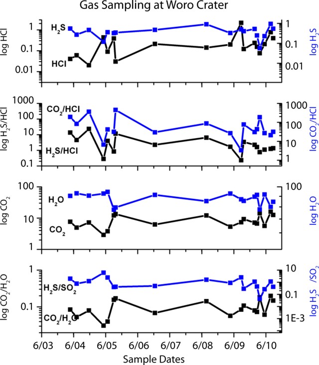 |
Figure 51. Gas sampling at Merapi's Woro Crater (a location map is posted in BGVN 32:02) conducted during June 2003-January 2011. Results from Giggenbach bottle collection and lab analysis for gas species are plotted on log scales. Right-hand vertical axis corresponds to upper (blue) data and trendlines. Left-hand vertical axis corresponds to the lower (black) data trendlines and data. Original concentration units were undisclosed (but Bulletin editors hope to clarify these units in later discussions on Merapi). Modified from BPPTK, 2011a. |
SO2 ranged from ~75 metric tons/day (t/d) to ~285 t/d and appeared to peak mid-year in 2005 and 2006 (figure 50). A sudden decrease of 50 t/d in January 2007 preceded an increasing trend that ended in mid-2008. These fluxes also had fewer sustained peaks around March 2008 and declined until the available record ends around March 2009.
The SO2 peak of ~200 t/d generally correlated with the 2005 mid-year episode of elevated seismicity that prompted the BPPTK (at that time called the Directorate of Volcanology and Geological Hazard Mitigation, "DVGHM") to raise the Alert Level from Normal to Advisory (from 1 to 2). However, there were no additional reports of plumes or increased dome activity then (BGVN 32:02).
In 2006, the Alert Level was raised to the highest level on 13 May due to intense dome growth and earthquake activity (BGVN 31:05), a time when SO2 reached ~225 t/d.
According to information recorded in Bulletin reports, the abrupt decrease of SO2 in late 2006-early 2007 did not appear to correlate with significant volcanism in that time interval. The gradual increasing-and-decreasing trend in SO2 flux from 2007 until the end of the record was marked by rare ash plumes (e.g. 19 March 2007, 9 Aug 2007, and 19 May 2008), and modest dome growth (BGVN 32:02). Bulletin reports also noted incandescence and ashfall had continued during 23 May-29 May 2007. MODVOLC thermal anomalies became rare after 5 September 2006 (BGVN 33:10).
Intermittent activity during 18 April-1 May 2011. Unrest at Merapi since the 2010 crisis was characterized by intermittent increases in seismicity as observed from 18 to 24 April 2011 (figure 52). Over the course of that week, rockfall signals doubled from the previous observation period and 39 multiphase events were recorded.
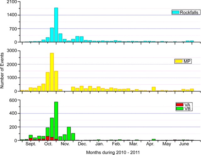 |
Figure 52. Histograms from September 2010 to June 2011 summarize the number of seismic events from four categories is summarized for Merapi. Events shown are rockfalls; MP, multiphase (shallow source, dominant frequency ~1.5 Hz); VA, deep volcano-tectonic earthquakes, 2.5-5 km below the summit; VB, shallow volcano-tectonic earthquakes, less than ~1.5 km below the summit. Tremor episodes were infrequent and thus excluded. Courtesy of BPPTK (Activity Report 6-12 June 2011). (A figure in BGVN 36:1/2 presented representative samples of these various waveforms.) |
BPPTK also reported that ground deformation was variable throughout this time period as EDM (Electronic Distance Meter) measurements were recorded across the summit. Measurements made on 18 April 2011 compared with those recorded on 25 April 2011 from the monitoring post of Selo showed the following changes: a difference in distance amounting to +8 mm (R1) and a change in movement amounting to 0.1 mm per day.
Measurements carried out on 18 April 2011 compared to those of 24 April 2011 from Jrakah monitoring post indicated the following changes: a difference in distance amounting to -4 mm (R1) with a change in movement amounting to 0.5 mm per day, and a difference in distance of +6 mm (R2) with a movement of 0.7 mm per day.
Plumes of ash and gas reached an altitude of ~800 m on 24 and 25 April. Communities near Merapi's flanks reported ashfall on 29 April, 30 April, and 1 May 2011. (BPPTK Activity Report 25 April-1 May 2011).
Ongoing hazards. The recent weekly report by BPPTK (20 March to 12 June 2011), described plumes of gas and ash that occurred regularly. As measured from above the summit, the average height of these plumes was ~500 m; a maximum height of 900 m was recorded on 20 April. The tallest plume was accompanied by a ramping up of earthquakes and the regular occurrence of lahars, some hot enough to steam while racing through river drainages (figure 53).
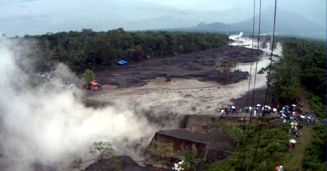 |
Figure 53. On 21 March 2011 and 14 April 2011 steaming lahars descended Merapi's flanks. This photo was taken on 14 April 2011from a CCTV camera installed in Pencar village, less than 20 km S of Merapi in the Desa Bimomartani region. Note Merapi volcano in upper right-hand area of the photo. Courtesy of BPPTK (Activity Report discussing 11-17 April 2011). |
A large amount of volcanic ash fell from Merapi's explosive eruptions in 2010; this has aggravated slope stability and led to increased lahar hazards. In an interview on 11 April 2011 for Kompas News, Subandriyo, the Head of the BPPTK explained that "only about 30 percent" of the material that fell on Merapi's flanks has been remobilized by erosion. "Therefore, the threat of [lahars] will occur two to three years ahead."
As of June 2011, 15 major lahars had occurred since November 2010. The worst occurred on 23 January 2011 along the eroded banks of the Putih river. The major highway between Magelang and Yogyakarta was cut off when a 60 m wide section of blacktop was torn away by torrential mudflows. As a result, hundreds of homes within 12 different villages near the river were inundated forcing 5,000 people to flee. There were three fatalities.
Major infrastructure was also affected; 52 levees were damaged and 14 bridges were destroyed. Intense lahar damage was also reported along the SE rivers: Blongkeng, Batang, Progo, Code, and Gendol.
References. Allard, P., Métrich, N., and Sabroux, J.-C., 2011, Volatile and magma supply to standard eruptive 549 activity at Merapi volcano, Indonesia. EGU General Assembly 2011, Geophysical 550 Research Abstracts 13, EGU 2011-13522 (2011).
Andreastuti, S., Costa, F., Pallister, J.,Sumarti., S., Subandini, S., Heriwaseso, A., Kurniadi, Y. , Petrology and pre-eruptive conditions of the 2010 Merapi magma. EGU General Assembly 2011, Geophysical 550 Research Abstracts 13, EGU2011-5150 (2011).
BPPTK, Volcano Technical Research Center, 2011a, Geochemistry of Merapi. (URL: http://www.merapi.bgl.esdm.go.id/aktivitas_merapi.php?page=aktivitas-merapi&subpage=geokimia)BPPTK, Volcano Technical Research Center, 2011b, Monitoring of Geochemical and Temperature of Merapi. (URL: http://www.merapi.bgl.esdm.go.id/pages.php?page=geokimia-dan-suhu)
Schmincke, H.-U, 2004, Volcanism, Berlin:Springer, 324 pp.
Jousset, P., 12/6/10, Centennial Eruption at Merapi volcano: October/November 2010, MIAVITA, European Commission. (URL: http://miavita.brgm.fr/Documents/MIAVITA-Merapi-eruption.pdf)
Sayudi, D.S., Nurnaning, A., Juliani, DJ., Muzani, M.; 2010, "Peta Kawasan Rawan Bencana Gunungapi Merapi, Jawa Tengah Dan Daerah Istimewa Yogyakarta 2010," (The map of the Rawan Bencana Gunungapi Merapi Region, Central Java: Yogyakarta Special District 2010), Volcano Technical Research Center (Balai Penyelidikan dan Pengembangan Teknologi Kegunungapian, "BPPTK"). (URL: http://www.merapi.bgl.esdm.go.id/peta/2011/04/KRBGMerapi2010FINALcopyright_78a74b.jpg)
Siebert L., Simkin T., and Kimberly P., 2010, Volcanoes of the World, 3rd edition, University of California Press, Berkeley, 558 p.
Surono, Jousset, P., Pallister, J., Boichu, M., Buongiorno, M.F., Budisantoso, A., Costa, F., Andreastuti, S., Prata, F., Schneider, D., Clarisse, L., Humaida, H., Sumarti, S., Bignami, C., Griswold, J., Carn, S., Oppenheimer, C., (in review), 100-year explosive eruption of Java's Merapi volcano, Journal of Volcanology and Geothermal Research.
Williams-Jones, G. and Rymer, H., 2000, Hazards of Volcanic Gases, in Sigurdsson, H., ed., Encyclopedia of Volcanoes: San Diego, California, Academic Press, p. 997-1004.
Geological Summary. Merapi, one of Indonesia's most active volcanoes, lies in one of the world's most densely populated areas and dominates the landscape immediately north of the major city of Yogyakarta. It is the youngest and southernmost of a volcanic chain extending NNW to Ungaran volcano. Growth of Old Merapi during the Pleistocene ended with major edifice collapse perhaps about 2,000 years ago, leaving a large arcuate scarp cutting the eroded older Batulawang volcano. Subsequent growth of the steep-sided Young Merapi edifice, its upper part unvegetated due to frequent activity, began SW of the earlier collapse scarp. Pyroclastic flows and lahars accompanying growth and collapse of the steep-sided active summit lava dome have devastated cultivated lands on the western-to-southern flanks and caused many fatalities.
Information Contacts: Volcano Technical Research Center (Balai Penyelidikan dan Pengembangan Teknologi Kegunungapian, "BPPTK") (URL: http://www.merapi.bgl.esdm.go.id/index.php); Badan Nasional Penanggulangan Bencana (BNPB- Indonesian National Disaster Management Agency) (URL: http://dibi.bnpb.go.id); Center of Volcanology and Geological Hazard Mitigation (CVGHM), Jalan Diponegoro 57, Bandung 40122, Indonesia (URL: http://vsi.esdm.go.id/); IRIN News (URL: http://www.IRINnews.org); Jakarta Globe (URL: http://www.thejakartaglobe.com); The Jakarta Post (URL: http://www.thejakartapost.com); KompasNews, Jakarta, Indonesia (URL: http://www.Kompas.com); Mitigate and Assess risk from Volcanic Impact on Terrain and human Activities project (MIAVITA) (URL: http://miavita.brgm.fr/default.aspx); Act Forum Indonesia (URL: http://www.actalliance.org/); Relief Web (URL: https://reliefweb.int/).