Report on Barren Island (India) — June 2011

Bulletin of the Global Volcanism Network, vol. 36, no. 6 (June 2011)
Managing Editor: Richard Wunderman.
Barren Island (India) Evolving eruption emits tephra and continues in January 2011
Please cite this report as:
Global Volcanism Program, 2011. Report on Barren Island (India) (Wunderman, R., ed.). Bulletin of the Global Volcanism Network, 36:6. Smithsonian Institution. https://doi.org/10.5479/si.GVP.BGVN201106-260010
Barren Island
India
12.278°N, 93.858°E; summit elev. 354 m
All times are local (unless otherwise noted)
Barren Island, a young and growing mafic island-arc volcano in the Andaman Sea (figure 16), produced its first historically recorded eruption in 1787; a series of eruptions followed in later years. Evidence of eruptions again became clear in May 2005 as a result observations by the Indian Coast Guard.
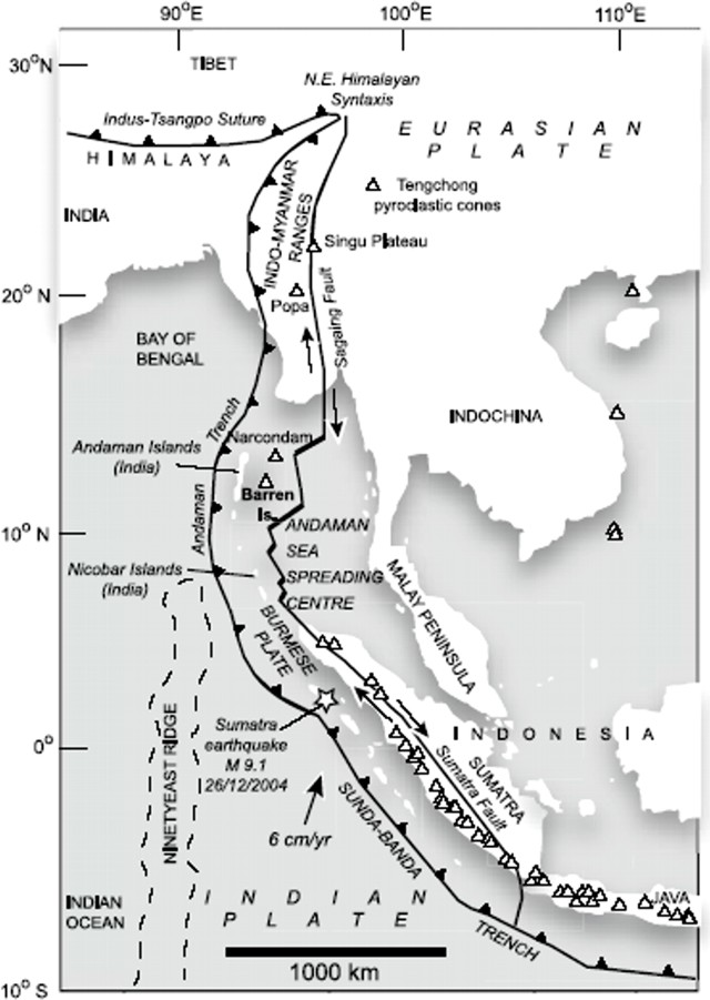 |
Figure 16. Map showing the location of Barren Island as part the S-trending volcanic arc extending between Burma (Myanmar) and Sumatra. It shows major geological and tectonic features of the NE Indian Ocean and SE Asia, along with the locations of the Andaman and Nicobar Islands, Barren Island, and Narcondam. White triangles are Holocene volcanoes (Siebert, and others, 2010). Taken from Sheth and others (2009) and from BGVN 36:03. |
A recent report on Barren Island (BGVN 35:01) reported occasional ash plumes and decreasing thermal alerts through January 2010. In our last report on Barren Island (BGVN 36:03) we described some new details about this volcano, particularly during the years 2005-2009, as reported by Sheth and others (2009) and the Geological Survey of India (GSI, 2009). The current report discusses activity at the volcano during January 2010-April 2011, including observations made by GSI (2011) during a January 2011 field trip and thermal anomalies detected by satellite.
Ash plumes. During 2010 and through mid-2011, the Darwin Volcanic Ash Advisory Centre reported ash plumes from Barren Island. Figure 17 shows a plume rising from the volcano in a 25 September 2010 satellite image.
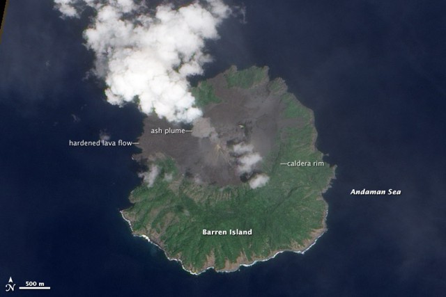 |
Figure 17. A plume of ash rises from Barren Island on 25 September 2010. The Advanced Land Imager (ALI) aboard the Earth Observing-1 (EO-1) satellite shows a dark-gray ash cloud rising from a volcanic cone that fills the island's central caldera. Dark, hardened lava flows cover the caldera floor, some extending to the ocean. Green vegetation covers the caldera rim and the outer slopes. Breaking waves line the southern coastline in white. This remote, uninhabited volcanic island is not monitored directly, but the Indian Coast Guard, passing pilots, and satellites have observed lava flows and ash plumes periodically since 2005. Courtesy of NASA Earth Observatory, image by Robert Simmon using ALI data from the NASA EO-1 team. |
The Darwin VAAC documented other plumes, for example, on 3 January 2010 a pilot reported that a plume rose to an altitude of 1.5 km. On 11 January 2010 an ash plume visible through satellite imagery rose to an altitude of 1.5 km and drifted 45 km S. On 23 January 2010 a pilot observed an ash plume that rose to a reported altitude of 3 km, but it was not identified on satellite imagery.
New insights from GSI. GSI (2011) discussed a scientific expedition to Barren Island made during 2-8 January 2011. The eruption still continued, but with lesser intensity as compared to the violent eruption observed during 2005 to 2009. The eruption was of a pulsative and explosive character (Strombolian type) where dark columns of a dense ash-laden steam with coarser pyroclasts (cinders, juvenile lava blocks) were ejected at 2- to 8-minute intervals.
The eruption discharged from two vents on the parasitic crater. That crater had developed over a subsidiary cinder cone (~ 500 m high) on the S wall of the main cinder cone of the 1991-95 eruption. Coarser incandescent pyroclasts rose sub-vertically to 100-150 m in height and tumbled down the volcanic cone. A thick column of ash-laden gray vapor was ejected to heights of ~ 150-200 m and typically rose in a mushroom shaped ash cloud.
Figure 18 shows the lower portion of an ash plume.
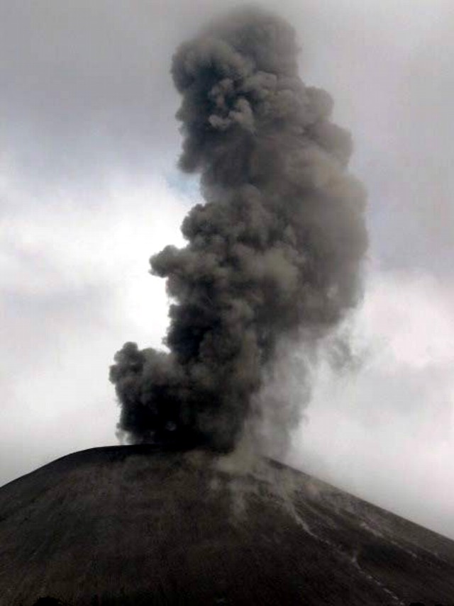 |
Figure 18. Barren Island emitting a column of ash-laden vapor. Bulletin editors noted two minor features: (1) dark spots to the left of the vent suggestive of local ash fall, and (2) small plumes near the ground surface, which appear similar to those discussed in the Fuego report (this issue, BGVN 36:06). Taken from GSI (2011). |
Significant changes were observed in the shape and height of the cinder cone in the 2-km-diameter caldera. The height of the cinder cone increased from ~ 350 m in 2005 to ~ 500 m in 2011. The main approach to the center of the island follows a valley leads to the breached NW side of the caldera wall. The valley was covered totally by a thick pile of repetitive sequences of assorted pyroclasts and lava from recent eruptions. Near the base of the cinder cone, in the NW part of the island, the accumulated thickness of the products from recent eruptions was ~ 100 m. Besides the main pyroclast deposits from lava in the W part of the valley, considerable deposits had filled up the valley in the NNW part of the island, overflowing the caldera wall and covering the pre-historic lava. The recent lava flows reached the sea front attaining a width of ~ 250 m at the coast (figure 19).
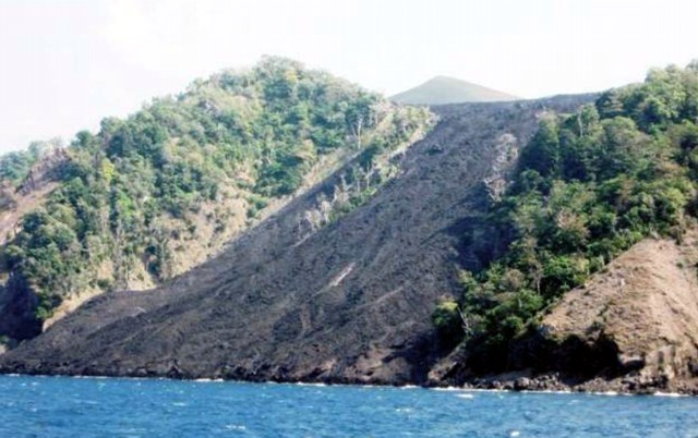 |
Figure 19. Lava flow emplaced between 2009-Jan 2011. Located on the NNW side of Barren Island with a width of flow at the coast of ~250 m. From GSI (2011). |
This is the first report of the lava and pyroclasts of recent eruptions in the NNW part of the island. The main lava flow and pyroclastic deposits discharged from the NW part of the crater,carried towards the W and NNW part of the valley, giving rise to new land forms.
The lava and associated eruptive products of the 1991 and 1994-95 explosions, which were exposed earlier near the mouth of the valley and on the S side of the valley, were covered by the recent tephra The coarser pyroclasts are highly vesiculated basaltic rocks where plagioclase occurs as the dominant phenocryst set in a glassy matrix. The pile of pyroclasts formed very uneven. Maximum height of the accumulated material was ~20 m. Fusion of individual cinders, spatter, and blocks produced bigger blocks.
MODVOLC Thermal Alerts. MODVOLC satellite thermal measurement showed frequent alerts for the following periods: 17 September through 5 November 2010 (nearly daily alerts), 14 December 2010 through 10 January 2011, and 29 March through 11 April 2011 (daily alerts). Alerts were absent during 13 February through 17 September 2010.
Recent history of major ash eruptions. Awasthi and others (2010) measured 14C dates of inorganic carbon in sediment beds, and Sr and Nd isotopic ratios of seven discrete ash layers, in a marine sediment core collected from 32 km SE of the Barren volcano. The study revealed that the volcano had seven major ash eruptions, at ~70, 69, 61, 24, 19, 15, and 10 kiloyears (ka) before present. The ash layers erupted from 70 ka through 19 ka have highly uniform Nd isotopic composition; eruptions since ~15 ka have highly variable isotopic compositions. The authors found that during 10-24 ka, the volcano had large ash eruptions spaced at ~4.5 ka intervals (~10, ~15, 19, and 24 ka). Isotopically correlating the precaldera lavas and ash exposed on the volcano to the uppermost ash layer in the core, the authors inferred that the caldera was younger than the last ~10 ka ash layer found in the core. This represents the hypothesis that the caldera formed as a result of a single, simple, symmetric collapse after Barren Islands major ash eruptions.
References. Awasthi, N., Ray, J.S., Laskar, A.H., Kumar, A., Sudhakar, M., Bhutani, R., Sheth, H.C., and Yadava, M.G., 2010, Major ash eruptions of Barren Island volcano (Andaman Sea) during the past 72 kyr: clues from a sediment core record, Bulletin of Volcanology, v. 72, pp. 1131-1136.
Geological Survey of India, 2009, The Barren Island Volcano, Explosive Strombolian type eruption observed during January 2009, Jan 2009 URL: http://www.portal.gsi.gov.in/ gsiImages/information/ N_BarrenJan09Note.pdf)
Geological Survey of India, 2011, Barren Volcano in January 2011: An explosive pulsative eruption (Strombolian) still continues, Eastern Region Geological Survey of India URL: http://www.portal.gsi.gov.in/gsiDoc/pub/cs_barren-eruption.pdf)
Sheth, H.C. , Ray, J.S., Bhutani, R., Kumar, A., and Smitha, R. S., 2009, Volcanology and eruptive styles of Barren Island: an active mafic stratovolcano in the Andaman Sea, NE Indian Ocean, Bulletin of Volcanology, v. 71, pp. 1021-1039 (DOI: 10.1007/s00445-009-0280-z).
Siebert, L., Simkin, T., and Kimberly, P, 2010, Volcanoes of the World: Third Edition, University of California Press, Berkeley, 551 p.
Geological Summary. Barren Island, a possession of India in the Andaman Sea about 135 km NE of Port Blair in the Andaman Islands, is the only historically active volcano along the N-S volcanic arc extending between Sumatra and Burma (Myanmar). It is the emergent summit of a volcano that rises from a depth of about 2250 m. The small, uninhabited 3-km-wide island contains a roughly 2-km-wide caldera with walls 250-350 m high. The caldera, which is open to the sea on the west, was created during a major explosive eruption in the late Pleistocene that produced pyroclastic-flow and -surge deposits. Historical eruptions have changed the morphology of the pyroclastic cone in the center of the caldera, and lava flows that fill much of the caldera floor have reached the sea along the western coast.
Information Contacts: Geological Survey of India (GSI), GSI Complex, Bhu Bijnan Bhavan, Block: DK-6, Sector-II, Salt LakeKolkata-700091 West Bengal, India (URL: http://www.portal.gsi.gov.in/); Darwin Volcanic Ash Advisory Centre (VAAC), Bureau of Meteorology, Northern Territory Regional Office, PO Box 40050, Casuarina, NT 0811, Australia (URL: http://www.bom.gov.au/info/vaac/).