Report on Changbaishan (China-North Korea) — August 2011
Bulletin of the Global Volcanism Network, vol. 36, no. 8 (August 2011)
Managing Editor: Richard Wunderman.
Edited by Robert Dennen.
Changbaishan (China-North Korea) Observatory notes high seismicity during mid-2002 to mid-2005
Please cite this report as:
Global Volcanism Program, 2011. Report on Changbaishan (China-North Korea) (Dennen, R., and Wunderman, R., eds.). Bulletin of the Global Volcanism Network, 36:8. Smithsonian Institution. https://doi.org/10.5479/si.GVP.BGVN201108-305060
Changbaishan
China-North Korea
41.98°N, 128.08°E; summit elev. 2744 m
All times are local (unless otherwise noted)
At the 25th General Assembly of the International Union of Geodesy and Geophysics (IUGG), the Chinese National Committee released an overview of data on Chinese volcanoes, especially Changbaishan volcano (figure 3), which they considered the most dangerous and the most likely to erupt (Fan and others, 2011; Liu and others 2011). Focusing on Changbaishan volcano and its summit caldera called Tianchi, Tianchi Volcano Observatory (TVO) released data collected since it formed in 1999. This report will summarize both the TVO's monitoring network and their findings from 1999 to 2010, focusing on the seismic crisis during mid-2002 to mid-2005. As clarification, the name Tianchi is used to refer to the ~ 5 km diameter summit caldera vent of the volcanic complex, and the name Changbaishan is used to refer to the complex in general. The latter name has many synonyms, including Baegdu, Baekdoosan, Baitoushan, Chang-pai-shan, Hakuto, and P'aektu-san.
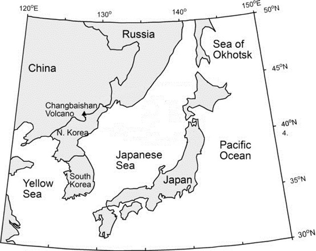 |
Figure 3. Geographic position of Changbaishan volcano, situated on the border between China and North Korea. Adapted from Machida and Arai (1983). |
To continuously monitor seismicity, TVO's Changbaishan volcano center was built in the highlands 40 km from the volcano, and five, two, and four seismic stations were installed within 15, 25, and 50 km of the volcano, respectively. Liu and others (2011) report that TVO's system "can detect M 0.1 volcanic events and give the [detailed] location of M 1.0 and larger volcanic events."
Seismic crisis. Our previous report on Changbaishan briefly discussed an increase in seismicity centered at the volcano in 2003 (BGVN 35:08). Figure 4 and table 1 illustrate that the increased seismicity occurred both in terms of the magnitude and the number of seismic events recorded. A histogram of the annual number of earthquakes from 2002 through 2005 shows a peak in 2003. M 2 and larger earthquakes became common in 2002, and peaked in late 2004. Note that tectonic earthquakes of M 4.4 and 4.0 occurred on 17 December 2004 and 15 April 2005, respectively, and are not related to this trend or Tianchi volcano (Liu and others, 2011). Following the seismic crisis, the number of earthquakes declined slowly, reaching background levels by 2006 (Liu and others, 2011). Liu and others (2011) break the seismic data into three periods over the TVO monitoring history (table 1). As is common with earthquakes at volcanoes around the world, seismic activity at Changbaishan often occurred in swarms, especially from 2002 to 2003, when hundreds of seismic events were sometimes recorded within a single day (figure 4, table 1).
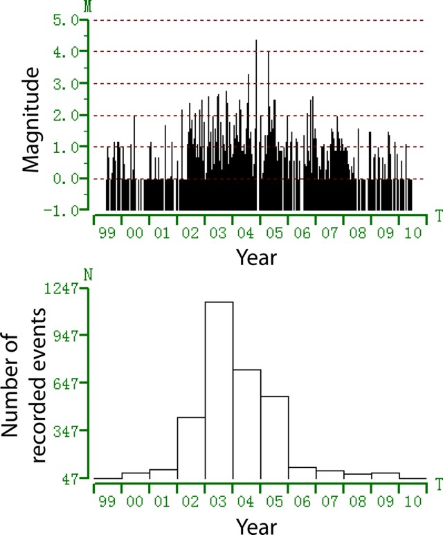 |
Figure 4. Time distribution of seismic events recorded at Tianchi volcano (Changbaishan) from mid-1999 to mid-2010. Top plot indicates magnitude of each seismic event; bottom plot indicates number of seismic events per year. From Liu and others (2011). |
Table 1. Tianchi volcano observatory (TVO) detected three distinct seismic episodes. * = Not including tectonic earthquakes of M 4.4 and 4.0 that occurred on 17 December 2004 and 15 April 2005, respectively. From Liu and others (2011).
| Date Range | Activity | Max. Magnitude | Number of events/time period |
| 1999-Jun 2002 | Background | 1.5 | Under 12/month. |
| Jul 2002-Jul 2005 | Peak (crisis) | 3.7* | Over 100/day, in a series of swarms. |
| Aug 2005-present | Recovery | -- | Under 12/month, generally. |
The hypocenters of earthquakes occurring at Changbaishan, and specifically the Tianchi caldera, were calculated from 2001 to present (figure 5). The majority of the earthquakes originated within 3 km of the Tianchi caldera rim (map distance), and within 5 km depth from the caldera rim.
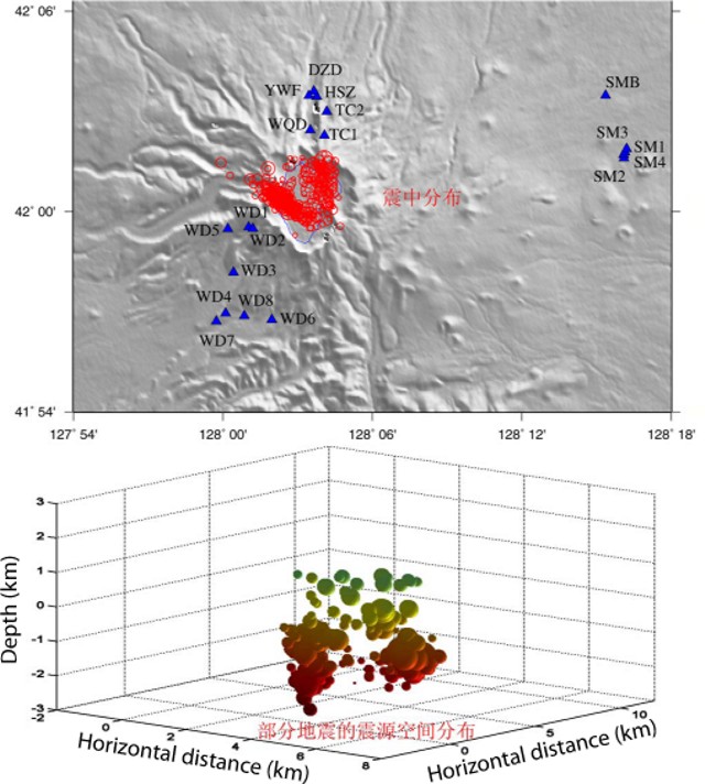 |
Figure 5. Calculated hypocenters for earthquakes occuring at Changbaishan volcano since 2002. (Top) plan-view distribution: triangles are seismic stations, red circles are hypocenters. (Bottom) depth distribution: colors from green to red indicate increasing depth (0 = sea level). Most earthquakes originated directly under the Tianchi caldera, within 5 km of the surface. From Liu and others (2011). |
Coinciding with the increased seismic activity from July 2002 to July 2005, the ground deformation of Changbaishan also entered into a period of inflation, as measured by GPS instruments (figure 6). Horizontal displacement reached a maximum of 4 cm between 2002 and 2003, and continued on a declining trend (figure 6; Liu and others, 2011). Similarly, vertical displacement reached a maximum of 38.6 mm between 2002 and 2003, and declined in the following years; a cumulative vertical displacement of 68.12 mm was measured from 2002 to 2005 (Liu and others, 2011). Vertical displacements of the N and W slopes of the volcano (measured once per year from 2006 to 2009) are presented in table 2.
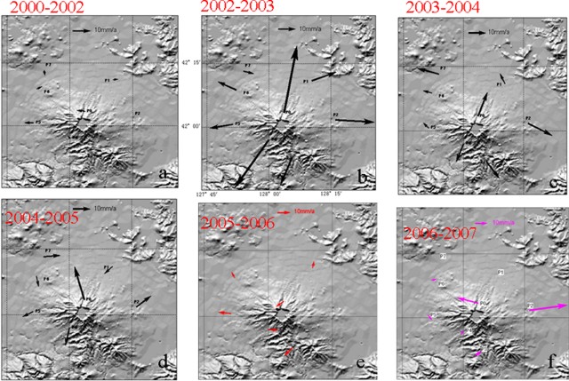 |
Figure 6. Horizontal displacement from GPS surveys from 2000 to 2007, showing inflation at Tianchi caldera of Changbaishan volcano. Reference arrow at the top of each frame is 10 mm/yr. From Liu and others (2011). |
Table 2. Vertical displacement measurements of the N and W slopes of Changbaishan, measured once per year from 2006 through 2009. From Liu and others (2011).
| Year | Slope | Elevation (mm) | Difference from previous year (mm) |
| 2006 | North | 901140.05 | -- |
| 2007 | North | 901148.20 | 8.15 |
| 2008 | North | 901149.26 | 1.06 |
| 2009 | North | 901151.70 | 2.44 |
| 2006 | West | 1084636.20 | -- |
| 2007 | West | 1084661.54 | 25.34 |
| 2008 | West | 1084659.21 | -2.33 |
| 2009 | West | 1084653.77 | -5.44 |
Magma source of Changbaishan. TVO monitored the gas flux of (among others) CO2, N2, He, H2, O2, and CH4, as well as the temperature of hot springs as a supplementary data set. Of particular interest is the measured helium (He) isotopic ratio, 3He/4He. The isotope 3He is often considered primordial. The concentration of 3He on Earth is considered to be essentially stable; the majority of 3He on Earth was trapped upon the formation of the Earth. 4He is a product of the alpha decay of heavy elements in the Earth's crust, and is still produced on Earth by alpha-particle emissions from heavy elements that have differentiated into the Earth's crust and then escape into the atmosphere. The mantle is depleted (relative to the crust and atmosphere) in 4He. 3He/4He ratios (R) of volcanic gases are compared with the common atmospheric 3He/4He ratio (Ra). If volcanic gases provide a particularly high R value (e.g., R = 5, or 5 Ra, indicating values 5 times the atmospheric 3He/4He ratio), then they are considered to be of mantle origin (i.e., depleted in 4He). Liu and others (2011) reported an average 3He/4He value of 5.61 Ra, and concluded that the gases being monitored are mantle sourced.
Liu and others (2011) also reported that He and H2 gas flux increased significantly in 2003 and 2004, associated with the above-mentioned increased volcano-seismicity of July 2002 to July 2005. They also reported He and H2 gas flux increases in October and November 2006, again associated with volcano-seismicity (as well as an M 2.6 tectonic earthquake on 11 November 2006).
From fluid geochemistry measurements, Liu and others (2011) reported that H2S and SO2 fluxes are low but suggested monitoring should increase in the event that the measured values increase.
References. Fan, Q., Sui, J., Zhao, Y., Li, N., and Sun, Q., 2011, Recent progress in active volcanoes in China, in China National Report on Volcanology and Chemistry of the Earth's Interior, for the 25th General Assembly of IUGG, Melbourne, Australia, 28 June-7 July 2011 (prepared by the Chinese National Committee for the International Association of Volcanology and Chemistry of the Earth's Interior (IAVCEI)), pgs. 15-18.
Liu, G., Yang, J., Wang, L., and Sun, J., 2011, The active level analysis of Changbaishan volcano, in China National Report on Volcanology and Chemistry of the Earth's Interior, for the 25th General Assembly of IUGG, Melbourne, Australia, 28 June - 7 July 2011 (prepared by the Chinese National Committee for the International Association of Volcanology and Chemistry of the Earth's Interior (IAVCEI)), pgs. 19-43.
Machida, H., and Arai, F., 1983, Extensive ash falls in and around the Sea of Japan from large late Quaternary eruptions, Journal of Volcanology and Geothermal Research, v. 18, p. 151-164.
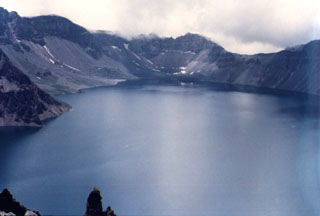
Geological Summary. Massive Changbaishan stratovolcano (also known as Baitoushan and by the Korean names of Baegdu, Paektu, or P'aektu-san), is located along the China/Korea border. A 5-km-wide, 850-m-deep summit caldera is filled by Lake Tianchi (Sky Lake). The 60-km-diameter dominantly trachytic and rhyolitic volcano was constructed over the Changbaishan (Laoheidingzi) shield volcano. Satellitic cinder cones are aligned along a NNE trend. One of the largest known Holocene explosive eruptions took place here about 946 CE, depositing tephra as far away as northern Japan and forming in part the present caldera; Yang et al. (2021) estimated the total erupted volume to be 40-98 km3. Minor eruptions have been recorded since the 15th century.
Information Contacts: Changbaishan Tianchi Volcano Observatory (TVO), Antu 133613, China.