Report on Santa Maria (Guatemala) — September 2011

Bulletin of the Global Volcanism Network, vol. 36, no. 9 (September 2011)
Managing Editor: Richard Wunderman.
Santa Maria (Guatemala) Eruption on 26 April 2010; ongoing activity through September 2011
Please cite this report as:
Global Volcanism Program, 2011. Report on Santa Maria (Guatemala) (Wunderman, R., ed.). Bulletin of the Global Volcanism Network, 36:9. Smithsonian Institution. https://doi.org/10.5479/si.GVP.BGVN201109-342030
Santa Maria
Guatemala
14.757°N, 91.552°W; summit elev. 3745 m
All times are local (unless otherwise noted)
The following report provides information from May 2010 through mid-October 2011 on Santa Maria volcano and its active dome complex, Santiaguito. The last report (BGVN 35:03) covered activity form 2008 to April 2010. The sources for this report are Guatemala's Instituto Nacional de Sismologia, Vulcanologia, Meteorologia e Hidrologia (INSIVUMEH) and Washington Volcanic Ash Advisory Center (VAAC). Santa Maria's eruptive history from the Global Volcanism Program database identifies the current eruption as beginning 22 June 1922 and continuing to mid-October 2011. The database's criteria for an eruption ending requires at least a 3-month pause in volcanic emissions (Siebert and others, 2010).
A recent report concerned the eruption of 26 April 2010, an event mentioned at the end of our last report (BGVN 35:03). A table summarizes some significant activity during the current reporting period. It is notable that during about nine months of 2011 (up to early October), MODVOLC measured thermal alerts several times each month (in each instance covering an area of 1 to 3 pixels). In comparison, during 2009, seven thermal alerts were measured and, during 2010, three alerts were measured.
More details on the 26 April 2010 eruption. Chigna (2010) noted the 26 April 2010 eruption of Santiaguito was associated with four large seismic events (M 3.9 at 0624, M 4.92 at 0648, M 5.89 at 0723, and M 5.72 at 0758). The seismic network recently established at the volcano permitted first-time recognition of some seismic signals known as tornillos ['screws' in Spanish; defined by Morrissey and Mastin (2000) as monochromatic, long period seismic events lasting a few minutes, with long codas of progressively decreasing amplitude that may be eruption precursors] (figure 34a). Pyroclastic flows were generated within the gullies on the S flank. An ash column rose to an altitude of 15 km, drifting to the W, NW, N, NE, and E, causing closure of village schools SW of Santiaguito and in the Quetzaltenango area. The ashfall was reported out to 7.3 km from the volcano; civil aeronautics alerted air traffic to avoid the plume within a radius of 80 km.
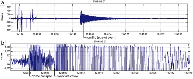 |
Figure 34. Examples of seismic records at Santa Maria. (a) Tornillo (screw) event. (b) Pyroclastic flow due to dome collapse; arrows indicate the onset of the primary events. Both seismic records taken from Chigna (2010). |
Activity from May 2010 to early-October 2011. Tables 3 and 4, summarizing activity from May 2010 through early-October 2011, document nearly continuous explosions, plumes, and pyroclastic flows. Various mass wasting processes were common, particularly block avalanches and lahars, often set into motion by precipitation.
Table 3. Summary of available information on explosions, plumes, and other volcanic emissions of Santa Maria volcano reported during May-December 2010. "--" is 'not reported' in original VAAC reports. Courtesy of INSIVUMEH, Washington VAAC, and MODVOLC.
| Date | Explosions noted | Plume color and composition | Plume Height | Drift Direction | Other Activity |
| 07 May 2010 | 17 weak to moderate | Gray | 2.9-3.4 km | SW | -- |
| 10 May 2010 | -- | White | 75 m | -- | -- |
| 19 May 2010 | Yes | Ash | 2.9-3.4 km | SW | Hot lahars carried blocks |
| 20 May 2010 | Yes | -- | 3.3 km | E | Pyroclastic flow to SW |
| 04 Jun 2010 | -- | -- | -- | -- | Lahar carried blocks |
| 19-20 Jul 2010 | 24 in 48-hour period | Ash | 300-900 m | SE, W | -- |
| 05-06 Aug 2010 | -- | Steam | -- | SW | Lahars carried trees, blocks |
| 01 Sep 2010 | -- | Ash | 100 m | SE | Pyroclastic flow to SW |
| 02 Sep 2010 | Yes | Ash | 500-1,000 m | W, SW | Block avalanches on W flank |
| 06 Sep 2010 | Yes | Ash | 500-1,000 m | W, SW | -- |
| 11 Sep 2010 | Yes | Ash | 1 km | E, SE | Pyroclastic flows (2) to 3 km SW |
| 13 Sep 2010 | -- | White | 100 m | S | -- |
| 22 Oct 2010 | Yes | Ash | 300 m | SW | Block avalanches on S and SW flanks |
| 26 Oct 2010 | -- | Steam | 150 m | -- | -- |
| 29 Oct 2010 | Yes | Ash | 900 m | SW | Pyroclastic flow down SW flank to 5 km S |
| 31 Oct 2010 | -- | Ash | -- | W | -- |
| 17, 22 Nov | Yes | Ash | 0.7-1 km | E, SE | -- |
| 19 Nov 2010 | -- | -- | -- | -- | Ashfall to the S |
| 08 Dec 2010 | Yes | Ash | 700 m | SE | Block avalanches; ashfall to SE |
| 10 Dec 2010 | -- | Ash | -- | 21 km W | -- |
| 13-14 Dec 2010 | Yes | Ash | 300-700 m | SE | Block avalanches; pyroclastic flows |
| 29-30 Dec 2010 | Yes | Ash | 300-600 m | S, SE | Ashfall |
Table 4. Summary of available information on explosions, plumes, and other volcanic emissions of Santa Maria volcano reported during January through early-October 2011. "--" is 'not reported' in original VAAC reports. Courtesy of INSIVUMEH, Washington VAAC, and MODVOLC.
| Date | Explosions noted | Plume color and composition | Plume Height | Drift Direction | Other Activity |
| 01 Jan 2011 | -- | -- | -- | W | Satellite thermal anomalies |
| 03-04 Jan 2011 | Yes | Ash | 700 m | SW | Avalanches to W flank |
| 05-06 Jan 2011 | Yes | Ash | 400-500 m | SW | -- |
| 08 Jan 2011 | -- | Ash? | -- | 30 km SSW | -- |
| 10-11 Jan 2011 | Yes | Ash | 600 m | SW, W | Avalanches on S and E flanks |
| 20-21 Jan 2011 | -- | Ash | 4.3-5.2 km | SW | Avalanches; rockfalls |
| 23-24 Jan 2011 | -- | Ash | 300 m | N | -- |
| 02-03 Feb 2011 | Yes | Ash | 300 m | -- |
References. Chigna, G., 2010, Eruption of Santiaguito (1402-03) 26 April 2010. INSIVUMEH (URL: http://www.insivumeh.gob.gt/).
Morrissey, M., and Mastin, L., 2000, Vulcanian eruptions, p. 463-475, in Sigurdsson, H. (ed), Encyclopedia of Volcanoes, Academic Press, San Diego.
Siebert, L., Simkin, T., and Kimberly, P., 2010, Volcanoes of the World, 3rd ed., Berkeley: University of California Press, 568 p.
Geological Summary. Symmetrical, forest-covered Santa María volcano is part of a chain of large stratovolcanoes that rise above the Pacific coastal plain of Guatemala. The sharp-topped, conical profile is cut on the SW flank by a 1.5-km-wide crater. The oval-shaped crater extends from just below the summit to the lower flank, and was formed during a catastrophic eruption in 1902. The renowned Plinian eruption of 1902 that devastated much of SW Guatemala followed a long repose period after construction of the large basaltic andesite stratovolcano. The massive dacitic Santiaguito lava-dome complex has been growing at the base of the 1902 crater since 1922. Compound dome growth at Santiaguito has occurred episodically from four vents, with activity progressing E towards the most recent, Caliente. Dome growth has been accompanied by almost continuous minor explosions, with periodic lava extrusion, larger explosions, pyroclastic flows, and lahars.
Information Contacts: Instituto Nacional de Sismologia, Vulcanologia, Meteorologia e Hydrologia (INSIVUMEH), Unit of Volcanology, Geologic Department of Investigation and Services, 7a Av. 14-57, Zona 13, Guatemala City, Guatemala (URL: http://www.insivumeh.gob.gt/inicio.html); Washington Volcanic Ash Advisory Center (VAAC), Satellite Analysis Branch (SAB), NOAA/NESDIS E/SP23, NOAA Science Center Room 401, 5200 Auth Rd, Camp Springs, MD 20748, USA (URL: http://www.ospo.noaa.gov/Products/atmosphere/vaac/); MODVOLC-HIGP, Hawai'i Institute of Geophysics and Planetology (HIGP) MODVOLC Thermal Alerts System, School of Ocean and Earth Science and Technology (SOEST), Univ. of Hawai'i, 2525 Correa Road, Honolulu, HI 96822, USA (URL: http://modis.higp.hawaii.edu/).