Report on Erebus (Antarctica) — September 2011

Bulletin of the Global Volcanism Network, vol. 36, no. 9 (September 2011)
Managing Editor: Richard Wunderman.
Erebus (Antarctica) Lava lake convects and spews spatter and gases in December 2010
Please cite this report as:
Global Volcanism Program, 2011. Report on Erebus (Antarctica) (Wunderman, R., ed.). Bulletin of the Global Volcanism Network, 36:9. Smithsonian Institution. https://doi.org/10.5479/si.GVP.BGVN201109-390020
Erebus
Antarctica
77.53°S, 167.17°E; summit elev. 3794 m
All times are local (unless otherwise noted)
This report includes first-hand observations of Erebus's crater, which includes the persistent Ray lava lake, a body that remained molten, though considerably crusted over, in December 2010. Several recent studies on Erebus presented maps and gas emissions measured by open-path FTIR spectroscopy in December 2004. Our last report on Erebus covered ongoing lava lake activity through October 2007 (BGVN 33:03). MODVOLC thermal alerts occurred during 2007 and continued at least into late 2011. Mt. Erebus is located on the western half of Ross Island (figure 11).
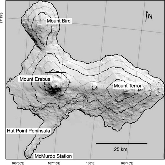 |
Figure 11. Shaded relief map of Ross Island showing Erebus, created from a digital elevation map. Taken from Csatho and others (2008). |
December 2010 observations. Csatho and others (2008) used laser scanning (LIDAR) acquired from aircraft in 2001 to study the morphology of the Erebus summit area (figure 12). The crater contains the persistent and convecting Ray lava lake. A second lava lake is occasionally active in the Werner vent (Werner lava lake). The authors noted the elevation of the surfaces of the inner crater's two lava lakes, both at ~3,515 m, was about the same as another active vent in the crater. Ray lava lake (~750 m2), which was discovered in 1972, sits in the inner crater's NE sector, and is larger than Werner lava lake (~166 m2).
 |
Figure 12. Morphology of the summit crater of Erebus compiled from laser imagery (ALS-LIDAR) acquired 30 December 2001. Taken from Csatho and others (2008). |
Kayla Iacovino posted a blog on 15 December 2010 about then-recent conditions on the summit of Erebus (Iacovino, 2011). She noted that the weather for the past few days was unusually clear (figure 13). In addition, she presented a shot of a churning lava lake (by Clive Oppenheimer) which was somewhat obscured by steam over the lake. Iacovino noted that during her 2010 visit, only Ray lava lake was active. It had shrunk in size (some of it had crusted over) since December 2009. She commented that "There were a lot of bursts of activity in the lake, including some bomb-throwing eruptions (although no bombs made it out of the crater) and a couple of very active fumaroles on the lava lake's perimeter. The plume was essentially constant."
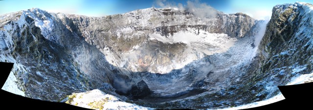 |
Figure 13. A December 2010 photo composite showing the inner crater at Erebus. The Ray lava lake lies to the left side of the crater floor. Courtesy of Laura Jones (New Mexico Tech; posted online at Iacovino, 2010). |
Oppenheimer provided two other views during the same December 2010 field season. One shows the crater, and the other, the active lava lake, large portions of which were covered by crust (figures 14 and 15).
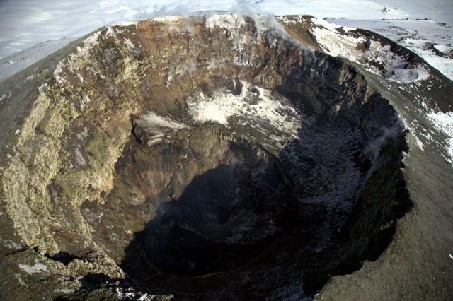 |
Figure 14. An aerial photo of Erebus taken from a helicopter looking at the main crater and its inner crater from an oblique angle. Courtesy of Clive Oppenheimer. |
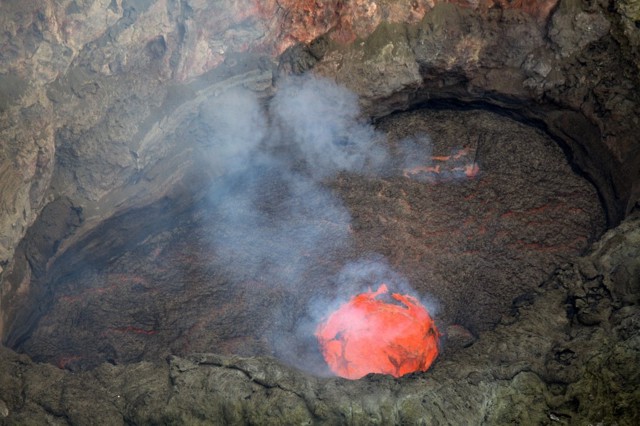 |
Figure 15. A photo of the floor and portions of the confining walls of the Ray lava lake, which contained a bright orange-red circular area with exposed molten material at the surface. As seen here, the exposed molten material discharged ample spatter and gases. Note the network of glowing cracks bounding and crossing the chilled darker portions of the lava lake. Courtesy of Clive Oppenheimer. |
2004 gas measurements. A study of the gas emissions conducted in December 2004 (Oppenheimer and Kyle, 2008) concluded with the statements below.
"We measured the emissions of seven gas species from Werner and Ray lava lakes at Erebus volcano by open-path FTIR spectroscopy. The results are among the few available for a highly alkalic magmatic system. Compared to typical subduction zone related volcanoes, Erebus gas is CO2-rich (consistent with abundant CO2 in olivine hosted melt inclusions sampled from Erebus basanite), and the CO2/CO ratio is lower (and perfectly consistent with the oxygen fugacity of Erebus phonolite estimated from the composition of component minerals). Combination of the measured gas proportions with the estimated SO2 flux carried by the plume provides estimates of the fluxes of all the other species. This yields the first measurements of the fluxes of H2O (~860 Mg per day) and carbonyl sulfide (~0.5 Mg per day). By mass, CO2 is the major component of the plume, and the estimated CO2 flux is ~1,300 Mg per day....
"The H2O/CO2 ratio and HF content of the individual plumes emitted by the two lava lakes are distinct, and point to a more 'evolved' gas released from Werner lake. This could indicate that the Werner lake is fed by a shallow offshoot of the conduit that supplies the Ray lake, or that magma feeding Werner lake is more comprehensively degassed due to a higher degree of crystallization....
References. Oppenheimer, C., Kyle, P.R., 2008, Probing the magma plumbing of Erebus volcano, Antarctica, by open-path FTIR spectroscopy of gas emissions, Journal of Volcanology and Geothermal Research, v. 177, p. 743-754.
Csatho, B., Schenk, T., Kyle, P., Wilson, T. and Krabill, W. B., 2008, Airborne laser swath mapping of the summit of Erebus volcano, Antarctica: Applications to geological mapping of a volcano, Journal of Volcanology and Geothermal Research, v. 177, no. 3, 531-548.
Iacovino, K., 2010, A view from the top: great weather on Erebus, Science Friday, posted 15 December 2010; accessed 24 October 2011.(URL: http://www.sciencefriday.com/blog/2010/12/a-view-from-the-top-great-weather-on-erebus/
Geological Summary. Mount Erebus, the world's southernmost historically active volcano, overlooks the McMurdo research station on Ross Island. It is the largest of three major volcanoes forming the crudely triangular Ross Island. The summit of the dominantly phonolitic volcano has been modified by one or two generations of caldera formation. A summit plateau at about 3,200 m elevation marks the rim of the youngest caldera, which formed during the late-Pleistocene and within which the modern cone was constructed. An elliptical 500 x 600 m wide, 110-m-deep crater truncates the summit and contains an active lava lake within a 250-m-wide, 100-m-deep inner crater; other lava lakes are sometimes present. The glacier-covered volcano was erupting when first sighted by Captain James Ross in 1841. Continuous lava-lake activity with minor explosions, punctuated by occasional larger Strombolian explosions that eject bombs onto the crater rim, has been documented since 1972, but has probably been occurring for much of the volcano's recent history.
Information Contacts: Kayla Iacovino and Clive Oppenheimer, Cambridge University, Department of Geography, Downing Place, Cambridge, CB2 3EN, UK; Laura K. Jones, Department of Earth and Environmental Science, New Mexico Tech, Socorro, NM 87801, USA; Hawai'i Institute of Geophysics and Planetology (HIGP) MODVOLC Thermal Alerts System, School of Ocean and Earth Science and Technology (SOEST), Univ of Hawai'i, 2525 Correa Road, Honolulu, HI 96822, USA (URL: http://modis.higp.hawaii.edu/).