Report on Kizimen (Russia) — October 2011
Bulletin of the Global Volcanism Network, vol. 36, no. 10 (October 2011)
Managing Editor: Richard Wunderman.
Kizimen (Russia) New lava and pyroclastic flows during February-September 2011
Please cite this report as:
Global Volcanism Program, 2011. Report on Kizimen (Russia) (Wunderman, R., ed.). Bulletin of the Global Volcanism Network, 36:10. Smithsonian Institution. https://doi.org/10.5479/si.GVP.BGVN201110-300230
Kizimen
Russia
55.131°N, 160.32°E; summit elev. 2334 m
All times are local (unless otherwise noted)
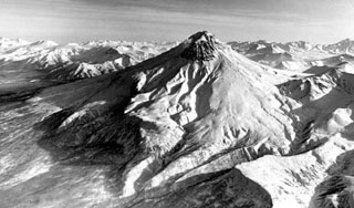
This report covers behavior at Kizimen (figure 9) during February-September 2011, an interval where the volcano emitted substantial ash plumes (often blowing towards major air traffic routes, in four cases with plumes 300-475 km long). Viscous block lava flows extended over 2 km from the vent. The progression of this eruption can be divided into three stages: increased seismicity, which began 1.5 years before the eruption (BGVN 35:02); gas-and-steam emissions starting on 11 November 2010, and the eruption, which began on 9 December 2010 (BGVN 36:01). The eruption continued through at least September 2011.
 |
Figure 9. (upper left) Regional location of Kizimen on Kamchatka Peninsula, Russia; red square indicates area of enlarged map. (lower right) Local setting of Kizimen among neighboring volcanoes. Regional map was found on the internet, authorship unknown. Local map was provided by Droznin Valery (Institute of Volcanology and Seismology, Russian Academy of Sciences, Far Eastern Branch). |
During February to September 2011, scientists continued to observe seismicity that consisted of a large number of weak, local surface earthquakes (sometimes accompanied by significant seismic noise) and weak volcanic tremor. The Kamchatka Branch of the Geophysical Service of the Russian Academy of Sciences (KB GS RAS) reported a substantial increase in the number of recorded earthquakes during August-September 2011 (figure 10a). KB GS RAS observers also noted a nearly continuous thermal anomaly (figure 10b) coupled with volcanic activity consisting of both pyroclastic flows and a steady stream of gas-and-ash plumes that drifted 20 to 475 km from the volcano (table 1).
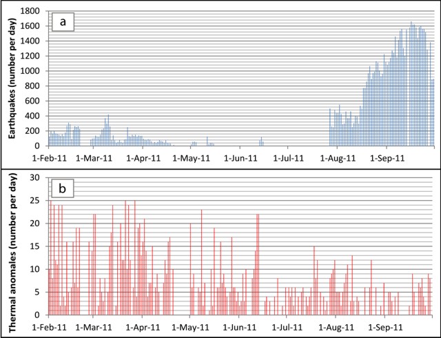 |
Figure 10. For Kizimen, a) the number of earthquakes per day and b) number of thermal anomaly pixels per day during February-September 2011. Data from Kamchatka Branch of the Geophysical Service of the Russian Academy of Sciences (KB GS RAS). |
Table 1. Summary of selected significant volcanic ash plumes during February-August 2011. This table records four days with plume lengths of greater than 300 km. One plume, on 2 April, extended 475 km SE. Data from KB GS RAS.
| Date | Ash plume distance (km) | Direction blown |
| 01 Feb 2011 | 350 | NE |
| 02 Feb 2011 | 50 | NE |
| 03 Feb 2011 | 150 | ESE |
| 04 Feb 2011 | 260 | ESE |
| 05 Feb 2011 | 65 | NE |
| 06 Feb 2011 | 131 | NNE |
| 07 Feb 2011 | 247 | E |
| 14 Feb 2011 | 57 | ESE |
| 01 Mar 2011 | 180 | NW |
| 02 Mar 2011 | 100 | NW |
| 04 Mar 2011 | 95 | NW |
| 05 Mar 2011 | 142 | NW |
| 11 Mar 2011 | 22 | NE |
| 12 Mar 2011 | 90 | NW |
| 17 Mar 2011 | 20 | SW |
| 21 Mar 2011 | 200 | NE |
| 22 Mar 2011 | 230 | NE |
| 23 Mar 2011 | 65 | NE |
| 27 Mar 2011 | 233 | SE |
| 28 Mar 2011 | 182 | SE |
| 29 Mar 2011 | 300 | NE |
| 31 Mar 2011 | 33 | E |
| 01 Apr 2011 | 160 | SE |
| 02 Apr 2011 | 475 | SE |
| 03 Apr 2011 | 125 | NW |
| 05 Apr 2011 | 85 | SE |
| 06 Apr 2011 | 260 | SE |
| 07 Apr 2011 | 220 | SE |
| 10 Apr 2011 | 225 | SE |
| 15 Apr 2011 | 87 | NW |
| 16 Apr 2011 | 245 | NW |
| 17 Apr 2011 | 32 | W |
| 18 Apr 2011 | 145 | W |
| 02 May 2011 | 78 | NW |
| 03 May 2011 | 280 | SW |
| 04 May 2011 | 34 | SE |
| 14 May 2011 | 23 | S |
| 11 Jun 2011 | 65 | SE |
| 12 Jun 2011 | 433 | SE |
| 19 Aug 2011 | 60 | SE |
A rose diagram created from the data in table 1 showed that plumes predominantly drifted SE (13 cases, figure 11). The longest plume (475 km on 2 April) also extended to the SE.
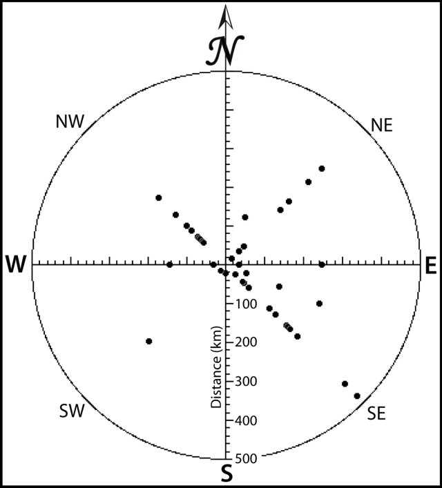 |
Figure 11. A rose diagram created from table 1; each point plotted represents the direction and distance traveled by an individual Kizimen plume. Based on data from KB GS RAS. |
Ash dispersal from Kizimen has strong implications for aviation, as the routes of major aircraft lie to the E of the volcano and many of the plumes traveled in directions between NE and SE. Many plumes, most notably the farthest reaching plumes, drifted SE. Eastward components (between SE and NE) make up 25 cases, over half of the 40 total cases shown in table 1.
Several events occurred during April: explosive emissions ejected ash and rock, and effusive lava flows on the upper flanks originated from summit crater vents. On 16 April, lava flows appear to have melted snow, and meltwater drained into Lake Kronotskoe. On 26 July, lava on E slope flowed 1 km from a summit vent.
September 2011 fieldwork. During fieldwork to Kizimen in September 2011, volcanologists observed lava flow and pyroclastic-flow deposits (figure 12). According to Natalia Malik (2011), on 14 September 2011, the volcano erupted constantly, and earthquakes were felt. The lava flow front on the E slope reached 1,300 m elevation, extending ~ 2.3 km from the vent area. The thickness of the flow, based on a visual estimate, was ~ 50 m. The bottom of the flow produced hot avalanches that were incandescent at night.
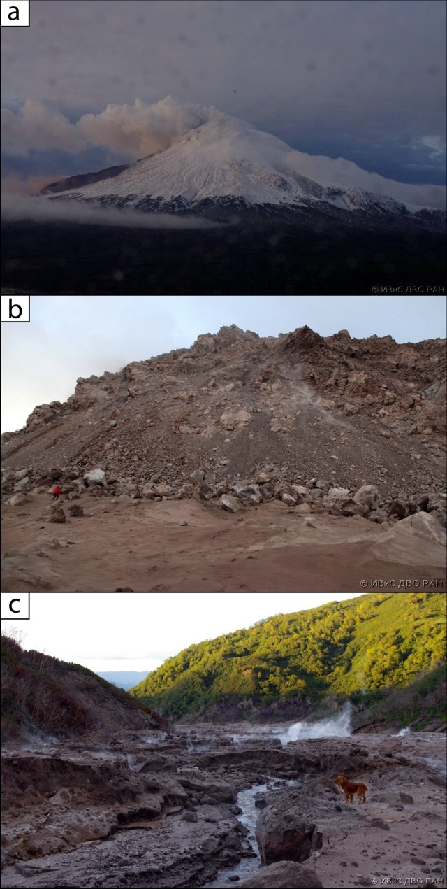 |
Figure 12. a) View of Kizimen's N side from a helicopter with a fresh lava flow (dark area at left) descending the E slope. Note the thick steam plume from the summit. b) Fresh lava flow front on the E flank; person at left for scale. c) Pyroclastic-flow deposit in Poperechny Creek, on the NE side of the volcano; for scale, the dog is ~0.5 m tall. Photos taken by Natalia Malik in September 2011. |
In the valley of Poperechny Creek on the NE flank of the volcano, observers documented fresh, hot pyroclastic-flow deposits, which locally emitted steam and other gases (figure 12c). Surface water caused erosion of the pyroclastic flow deposit's surface (figure 12c). The thickness of the pyroclastic-flow deposits was estimated to be on the order of 3 m. During emplacement of the pyroclastic flows, trees and vegetation on the valley's lower slopes suffered extensive damage.
Several satellite images also helped to depict Kizimen's recent activity (figure 13). Notice the striking differences between the images from 6 September 2009 and 5 September 2011.
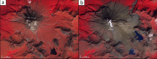 |
Figure 13. a) Kizimen false-color satellite image acquired on 6 September 2009, showing the pre-eruptive state of the volcano. b) False-color satellite image acquired on 5 September 2011, showing the enormous change over large areas of the volcano, particularly on the E side. A prominent lava flow is present on the E flank. Freshly erupted material, such as tephra and lahars, blocked drainages, and formed a new lake. Freshly erupted material appears brown and vegetation appears red. These images were acquired by the Advanced Spaceborne Thermal Emission and Reflection Radiometer (ASTER) aboard the Terra satellite. Courtesy of NASA Earth Observatory. |
According to NASA Earth Observatory, the new volcanic deposits (appearing brown in figure 13b) have covered much of the vegetation (red) on the slopes of the volcano, especially to the E. Likewise, volcanic material has filled rivers and streams around the volcano. The same photograph shows a modest volcanic plume rising from Kizimen's summit, accompanied by a smaller plume from a fumarole to the NW. These images illustrate the growth of a stratovolcano: lava flows interbedded with layers of volcanic ash, cinders, blocks, and bombs. The lava flow on Kizimen is a viscous block lava (that forms the steep-sided flows seen in figure 12b). As the flow slowly advanced down the E side of the volcano, the surface collapsed, sending boulders, ash, and other material into the valley below.
Reference: Malik, Natalia, 2011, Current activity of Kizimen, September 2011 (in Russian): Institute of Volcanology and Seismology, Russian Academy of Sciences (http://www.kscnet.ru/ivs/volcanoes/inform_messages/2011/Kizimen_092011/Kizimen_092011.html).
Geological Summary. Kizimen is an isolated, conical stratovolcano that is morphologically similar to St. Helens prior to its 1980 eruption. The summit consists of overlapping lava domes, and blocky lava flows descend the flanks of the volcano, which is the westernmost of a volcanic chain north of Kronotsky volcano. The 2334-m-high edifice was formed during four eruptive cycles beginning about 12,000 years ago and lasting 2000-3500 years. The largest eruptions took place about 10,000 and 8300-8400 years ago, and three periods of long-term lava dome growth have occurred. The latest eruptive cycle began about 3000 years ago with a large explosion and was followed by intermittent lava dome growth lasting about 1000 years. An explosive eruption about 1100 years ago produced a lateral blast and created a 1.0 x 0.7 km wide crater breached to the NE, inside which a small lava dome (the fourth at Kizimen) has grown. Prior to 2010, only a single explosive eruption, during 1927-28, had been recorded in historical time.
Information Contacts: Kamchatka Branch of the Geophysical Service of the Russian Academy of Sciences (KB GS RAS), Piip Ave. 9, Petropavlovsk-Kamchatsky, 683006, Russia; Kamchatka Volcanic Eruptions Response Team (KVERT), Institute of Volcanology and Seismology, Russian Academy of Sciences, Far East Division, 9 Piip Blvd., Petropavlovsk-Kamchatsky 683006, Russia (URL: http://www.kscnet.ru/ivs/); Sergey Senukov, Kamchatka Branch of the Geophysical Service, Russian Academy of Sciences (KB GS RAS), (URL: http://www.emsd.ru/); Valery Droznin and Natalia Malik, Institute of Volcanology and Seismology Russian Academy of Sciences, Far Eastern Branch, 9 Piip Blvd., Petropavlovsk-Kamchatsky 683006, Russia; NASA Earth Observatory (URL: http://earthobservatory.nasa.gov/).