Report on Soputan (Indonesia) — November 2011

Bulletin of the Global Volcanism Network, vol. 36, no. 11 (November 2011)
Managing Editor: Richard Wunderman.
Edited by Robert Dennen.
Soputan (Indonesia) Eruptions in July and August 2011
Please cite this report as:
Global Volcanism Program, 2011. Report on Soputan (Indonesia) (Dennen, R., and Wunderman, R., eds.). Bulletin of the Global Volcanism Network, 36:11. Smithsonian Institution. https://doi.org/10.5479/si.GVP.BGVN201111-266030
Soputan
Indonesia
1.112°N, 124.737°E; summit elev. 1785 m
All times are local (unless otherwise noted)
Soputan volcano, Sulawesi, Indonesia (figure 4) was relatively quiet for more than two years following our last report in September 2008 (BGVN 33:09). Thermal anomalies appeared in late May 2011 and in late June 2011, Soputan re-commenced eruptive activity. This report covers activity at Soputan during 2011 (through 2 October). Unless otherwise noted, data was reported by the Center for Volcanology and Geological Hazard Mitigation (CVGHM).
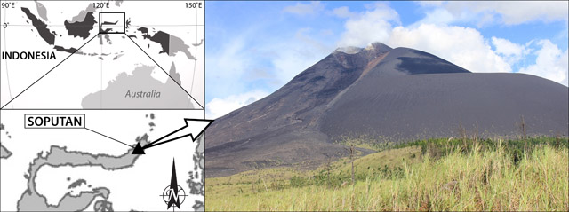 |
Figure 4. A photograph of Soputan volcano, taken 6 March 2011 by Flickr account user Akhal-Téké. Index maps at left show the location of Soputan volcano on the island of Sulawesi (close-up, bottom) in Indonesia (top). Index maps modified from MapsOf.net (top) and Ginkgo Maps (bottom). |
The first signs of the June-October eruption at Soputan occurred with some diffuse white plumes in June reaching 25-150 m above the crater. After an increase in seismicity during 21 June-2 July, CVGHM raised the Alert Level from 2 to 3 (on a scale from 1-4); climbing the slopes of the volcano was prohibited, and residents were discouraged from going within 6 km of Soputan's crater.
A Strombolian eruption, reported at 0603 on 3 July, generated an ash plume that rose 6 km altitude and drifted W. The eruption plume was captured in a NASA Earth Observatory satellite image (figure 5). A pyroclastic flow traveled up to 4 km W. A 10 pixel MODVOLC thermal alert was triggered at 0225 (UTC) on the same day (figure 5, table 8).
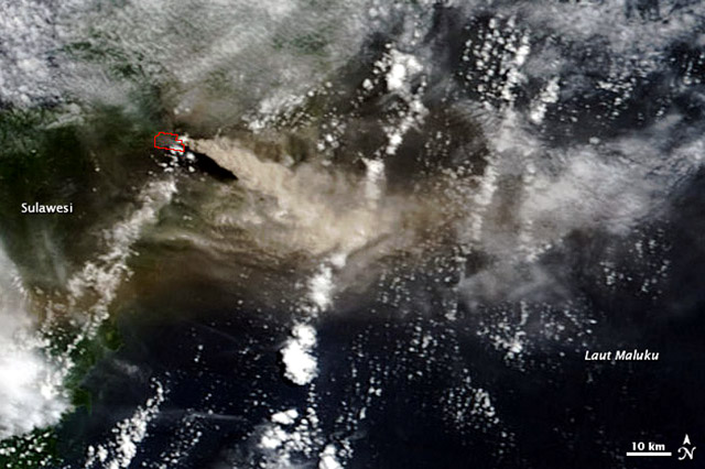 |
Figure 5. A natural color satellite image of the eruptive plume generated at Soputan on 3 July 2011. The plume is seen here drifting E over Laut Maluku (Molucca Sea); the brownish color of the plume indicates that it consisted of both gas and ash. The red outline highlights the area of the 10-pixel MODVOLC thermal alert (table 2) of the same day. Courtesy of NASA Earth Observatory. |
Table 8. MODVOLC thermal anomalies recorded at Soputan in 2011. A 58 pixel thermal anomaly was recorded on 2 October 2011, but was omitted due to the sun-glint angle being below 12°. The University of Hawaii states that "If a pixel has a sun-glint angle of less than 12° it is potentially contaminated by sunglint and should not be trusted." Courtesy of HIGP Thermal Alerts System, University of Hawaii. [Note that the 21 May 2011 pixel originally reported below (deleted) was actually located at some distance from the volcano in the ocean, and was most likely due to sunglint.]
| Date | Time (UTC) | Pixels | Satellite |
| 02 Jul 2011 | 1700 | 3 | Aqua |
| 03 Jul 2011 | 0225 | 10 | Terra |
| 03 Jul 2011 | 0520 | 2 | Aqua |
| 03 Jul 2011 | 1740 | 1 | Aqua |
| 09 Jul 2011 | 1705 | 2 | Aqua |
| 08 Aug 2011 | 1405 | 1 | Terra |
| 14 Aug 2011 | 1345 | 3 | Terra |
| 14 Aug 2011 | 1640 | 3 | Aqua |
| 15 Aug 2011 | 0205 | 2 | Terra |
| 15 Aug 2011 | 1725 | 3 | Aqua |
| 23 Aug 2011 | 0550 | 2 | Aqua |
The Jakarta Globe reported that, due to ash fall, the Indonesian Red Cross (Pa Merah Indonesia - PMI) distributed ~ 31,000 face masks to residents (figure 6). It also reported that Sutopo Purwo Nugroho, spokesman for the National Board for Disaster Managment (BNPB), said that "there is no need for evacuation because the nearest residents are living some 8 km from the mountain." Sam Ratui International Airport was closed for 3 hours (during 1200-1500) that afternoon, according to The Jakarta Globe. Following the eruption of 3 July, seismicity decreased, and the only reported activity was dense white plumes rising to 75 m above the crater on 18 July. The Alert Level was lowered to 2 on 19 July, allowing residents to come within 4 km of the crater.
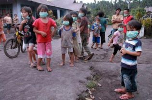 |
Figure 6. Residents near Soputan with face masks they received from the Indonesian Red Cross (Pa Merah Indonesia - PMI). Courtesy of the Jakarta Globe. |
Seismicity continued to decrease until 10 August. On 14 August, a plume containing ash rose to 1 km above the crater, and two other plumes rose to 1.3 km above the crater later in the day (figure 7). The Darwin Volcanic Ash Advisory Centre (VAAC) reported an ash plume that drifted more than 100 km W. The Alert Level was again raised to 3 on 14 August, once again prohibiting residents within 6 km of the crater.
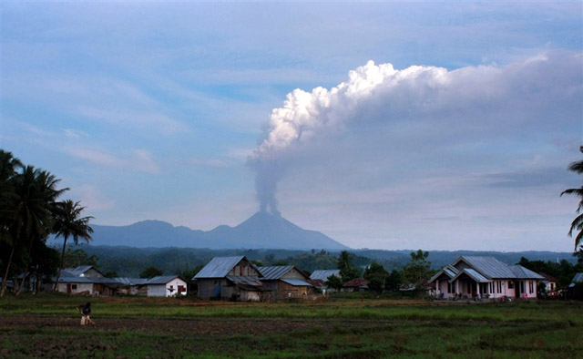 |
Figure 7. An ash plume from Soputan rising to greater than 1 km above the crater on 14 August 2011. In the foreground, a resident of one of the local towns is working in their field. Courtesy of Andreas/AFP-Getty Images. |
Following the eruptions of 14 August, seismicity decreased significantly, and small white plumes rose above the crater. The plumes steadily decreased from 200 m high above the crater (14-18 August) to, at most, 100 m above the crater (29 August-7 September). An early morning photograph captured an eruption on 15 August, showing a small plume and lava flows down the flank of Soputan (figure 8). On 8 September, the Alert Level was lowered to 2, allowing residents to come no closer than 4 km to the crater.
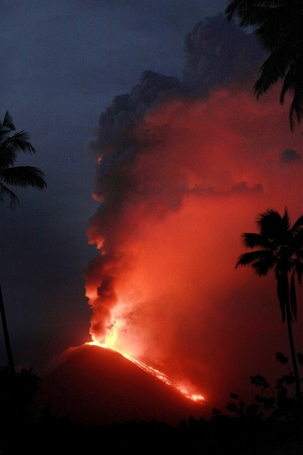 |
Figure 8. An early morning photograph of Soputan erupting on 15 August 2011. Lava flows down the flank of Soputan brightened the small eruptive plume billowing overhead. Courtesy of Andreas/AFP-Getty Images. |
Geological Summary. The Soputan stratovolcano on the southern rim of the Quaternary Tondano caldera on the northern arm of Sulawesi Island is one of Sulawesi's most active volcanoes. The youthful, largely unvegetated volcano is the only active cone in the Sempu-Soputan volcanic complex, which includes the Soputan caldera, Rindengan, and Manimporok (3.5 km ESE). Kawah Masem maar was formed in the W part of the caldera and contains a crater lake; sulfur has been extracted from fumarolic areas in the maar since 1938. Recent eruptions have originated at both the summit crater and Aeseput, a prominent NE-flank vent that formed in 1906 and was the source of intermittent major lava flows until 1924.
Information Contacts: Center for Volcanology and Geological Hazard Mitigation (CVGHM) Diponegoro 57, Bandung, Jawa Barat 40122, Indonesia (URL: http://www.vsi.esdm.go.id/); Akhal-Téké, Flickr photostream (URL: http://www.flickr.com/photos/51873088@N04/); MapsOf.net (URL: http://mapsof.net/); Ginkgo Maps (URL: http://www.ginkgomaps.com/); NASA Earth Observatory (URL: http://earthobservatory.nasa.gov/); Hawai'i Institute of Geophysics and Planetology (HIGP) Thermal Alerts System, School of Ocean and Earth Science and Technology (SOEST), Univ. of Hawai'i, 2525 Correa Road, Honolulu, HI 96822, USA (URL: http://modis.higp.hawaii.edu/); The Jakarta Globe, Citra Graha Building 11th Floor, Suite 1102, Jakarta 12950, Indonesia (URL: http://www.thejakartaglobe.com/); Darwin Volcanic Ash Advisory Centre (VAAC), Bureau of Meteorology, Northern Territory Regional Office, PO Box 40050, Casuarina, Northern Territory 0811, Australia (URL: http://www.bom.gov.au/info/vaac/); Andreas/AFP - Getty Images (URL: http://www.gettyimages.com/).