Report on Gamalama (Indonesia) — December 2011
Bulletin of the Global Volcanism Network, vol. 36, no. 12 (December 2011)
Managing Editor: Richard Wunderman.
Edited by Robert Dennen.
Gamalama (Indonesia) Eruption on 4 December 2011; lahars kill four and displace thousands
Please cite this report as:
Global Volcanism Program, 2011. Report on Gamalama (Indonesia) (Dennen, R., and Wunderman, R., eds.). Bulletin of the Global Volcanism Network, 36:12. Smithsonian Institution. https://doi.org/10.5479/si.GVP.BGVN201112-268060
Gamalama
Indonesia
0.81°N, 127.3322°E; summit elev. 1714 m
All times are local (unless otherwise noted)
Gamalama volcano, Indonesia, erupted on 4 December 2011, following precursory gas emissions and an increase in seismicity. Lahars killed at least four people, injured dozens, and thousands evacuated. Gamalama had remained at Alert Level 2 (on a scale from 1-4) since 11 May 2008 (BGVN 33:10). Coincident with the beginning of the eruption at 2300 on 4 December, CVGHM raised the Alert Level from 2 to 3, prohibiting access to areas within 2.5 km of the summit. In late January seismicity stabilized and the hazard status fell.
Precursory activity. The Center for Volcanology and Geological Hazard Mitigation (CVGHM) reported white plumes reaching 25 and 150 m above the summit of Gamalama on 1 and 4 December, respectively (figure 1). Clouds obscured the view on 2-3 December. Seismicity also increased during 1-4 December, with a sharp increase in the occurrence of shallow volcanic earthquakes, from one on 3 December to 47 on 4 December (table 2). Tremor was recorded continuously after 2258 on 4 December. At 2300, the Alert Level was raised to 3, and access to Hazard Zone II (areas within 2.5 km of the summit) was prohibited.
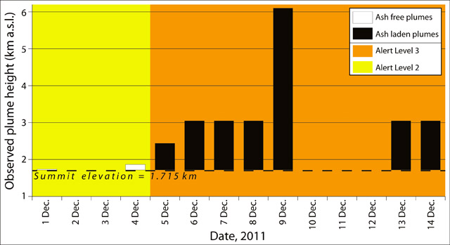 |
Figure 1. Reported plume heights at Gamalama during 1-14 December 2011. No plumes were reported by the Center for Volcanology and Geological Hazard Mitigation (CVGHM) or the Darwin Volcanic Ash Advisory Centre (VAAC) on 2-3 and 10-12 December. Plumes heights indicated in white were ash-free emissions, while those in black indicate plumes that contained ash. The Alert Level was raised from 2 (yellow) to 3 (orange) at 2300 on 4 December. Data courtesy of CVGHM and Darwin VAAC. |
Table 2. Precursory seismicity during 1-4 December 2011 at Gamalama. Note the sharp increase of shallow volcanic earthquakes on 4 December 2011; that day, tremor amplitude also increased by at least an order of magnitude. The symbol '--' indicates data not reported. Data courtesy of CVGHM.
| Dates | Shallow volcanic | Deep volcanic | Hot air blasts | Tremor amplitude | Teleseismic |
| 01 Dec 2011 | -- | -- | 2 | 0.5-1.5 mm | -- |
| 02 Dec 2011 | -- | 1 | 5 | -- | -- |
| 03 Dec 2011 | 1 | -- | 3 | -- | 2 |
| 04 Dec 2011 | 47 | 5 | 5 | up to 35 mm | -- |
Eruption. According to the Jakarta Post, most residents living on Gamalama's slopes evacuated, although some insisted on staying in their homes. Most of Ternate and its surrounding villages were covered in ash (figure 2), and ash fall caused the loss of electricity in some areas around the slopes of the volcano. No fatalities were reported.
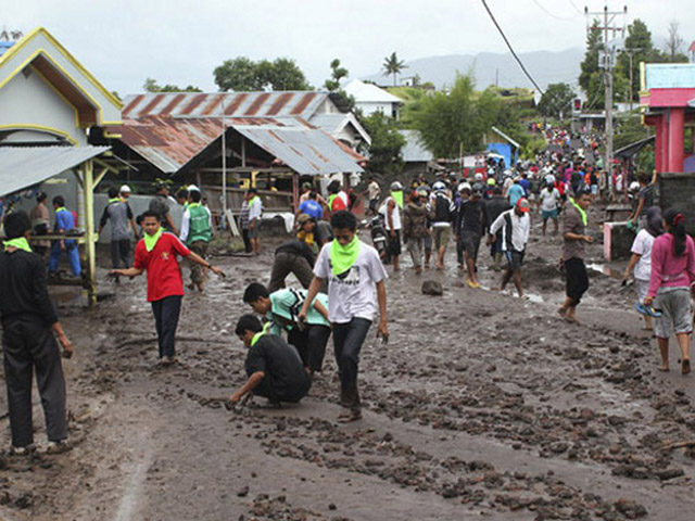 |
Figure 2. Residents in the Tubo district (3-4 km from the summit) walking on recently deposited (and most likely reworked) volcanic material that fell or was remobilized after an eruption of Gamalama. Photograph dated 5 December 2011; courtesy of Associated Press. |
Over the next 10 days (into mid-December) the Darwin Volcanic Ash Advisory Centre (VAAC) reported ash plumes that rose to 2.1-6.1 km altitude (figures 1 and 4). Some plumes drifted up to 140 km to the S, SE, and E. Three photos of plumes on 12 December appear in figure 3.
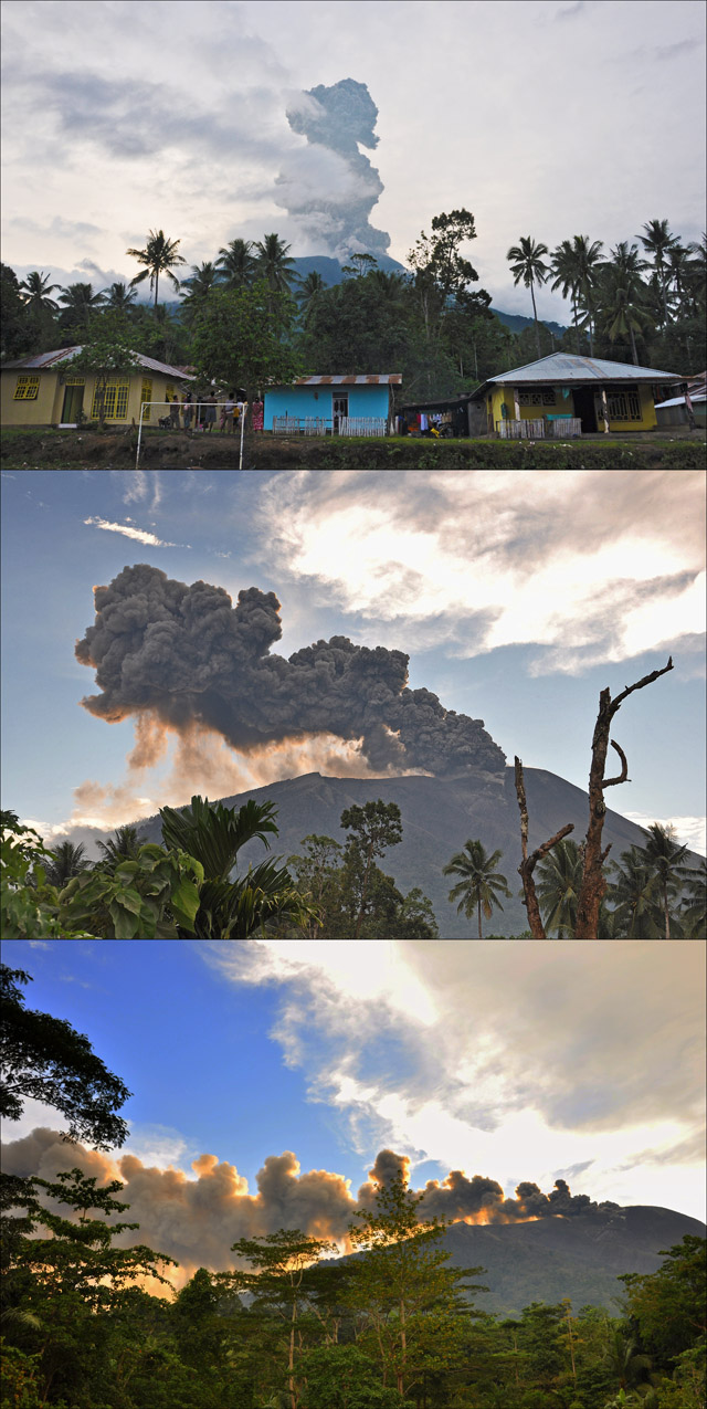 |
Figure 3. Photos of ash-bearing eruptive plumes from Gamalama taken on 12 December 2011. Courtesy of Andi Rosadi, Volcano Discovery. |
Fatal lahar. The Jakarta Post reported that heavy rainfall mobilized fresh ash deposits, spawning a lahar on 27 December 2011 that killed at least four people and injured dozens; many homes were destroyed in the Tubo and Tofure districts, and in locations along the Togorara and Marikurubu rivers (figure 4). On 1 January 2012, the Jakarta Post reported that up to 3,490 people were still being housed in ten different emergency shelters. It also reported that the National Disaster Mitigation Agency (Badan Nasional Penanggulangan Bencana, BNPB) had allocated 1.1 billion Indonesian Rupiah (US$121,000) in emergency funds for the residents affected by the eruption. The Jakarta Globe reported that thousands of farmers had their crops destroyed by ash erupted during December 2011. Agricultural losses are especially devastating, as the island has historically been a major producer of spices such as cloves.
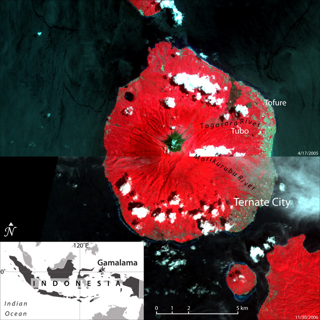 |
Figure 4. Combined Advanced Spaceborne Thermal Emission and Reflection Radiometer (ASTER) imagery of Gamalama (Ternate Island) on 17 April 2005 and 30 November 2006. Ternate City, the districts of Tubo and Tofure, and the Togorara and Marikurubu rivers are indicated. Index map shows regional location. ASTER imagery courtesy of the Geological Survey of Japan; index map modified from MapsOf.net. |
Eruption wanes. Following a month of decreasing activity, CVGHM decreased the Alert Level from 3 to 2 on 24 January 2012. The Alert Level notification cited that, since 23 December 2011, seismicity was dominated by tremor with relatively stable amplitude (0.5-2 mm) and hot air blasts that tended to decrease in occurrence (table 3). During the same period, observed plumes from Gamalama reached 25-100 m above the summit, none of which contained observable ash. In consequence of the lowered Alert Level, access to the summit craters of Gamalama was prohibited, and residents living along rivers descending the flanks of the volcano were advised to be aware of the dangers of lahars. In addition, the North Maluku Province Local Government was asked to prepare evacuation procedures in the case of an increase in activity.
Table 3. Seismicity at Gamalama from 24 December 2011 through 23 January 2012. CVGHM lowered the Alert Level from 3-2 on 24 January. Data courtesy of CVGHM.
| Dates | Shallow volcanic | Deep volcanic | Hot air blasts (per day) | Tremor amplitude |
| 24-31 Dec 2011 | 9 | 5 | 50 | 0.5-2 mm |
| 01-08 Jan 2012 | 2 | 8 | 73 | 0.5-1.5 mm |
| 08-17 Jan 2012 | 6 | 1 | 28 | 0.5-1 mm |
| 18-23 Jan 2012 | 5 | 5 | 30 | 0.5-1 mm |
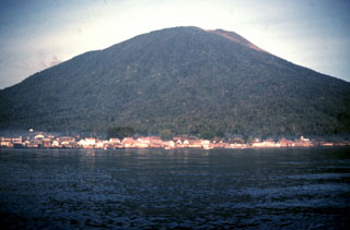
Geological Summary. Gamalama is a near-conical stratovolcano that comprises the entire island of Ternate off the western coast of Halmahera, and is one of Indonesia's most active volcanoes. The island was a major regional center in the Portuguese and Dutch spice trade for several centuries, which contributed to the extensive documentation of activity. Three cones, progressively younger to the north, form the summit. Several maars and vents define a rift zone, parallel to the Halmahera island arc, that cuts the volcano; the S-flank Ngade maar formed after about 14,500–13,000 cal. BP (Faral et al., 2022). Eruptions, recorded frequently since the 16th century, typically originated from the summit craters, although flank eruptions have occurred in 1763, 1770, 1775, and 1962-63.
Information Contacts: Center for Volcanology and Geological Hazard Mitigation (CVGHM), Jl. Diponegoro 57, Bandung, West Java, Indonesia, 40 122 (URL: http://www.vsi.esdm.go.id/); Darwin Volcanic Ash Advisory Centre (VAAC), Bureau of Meteorology, Northern Territory Regional Office, PO Box 40050, Casuarina, NT 0811, Australia (URL: http://www.bom.gov.au/info/vaac/); The Jakarta Post, Jl. Palmerah Barat 142-143, Jakarta 10270, Indonesia (URL: http://www.thejakartapost.com/); Associated Press (AP) (URL: http://www.apimages.com/); Andi Rosadi, Volcano Discovery (URL: http://www.volcanodiscovery.com/); Erik Klemetti/Wired (URL: http://www.wired.com/wiredscience/eruptions); Geological Survey of Japan (URL: http://www.gsj.jp/); MapsOf.net (URL: http://mapsof.net/); The Jarkarta Globe, Citra Graha Building, 11th Floor, Suite 1102, Jl. Jend. Gatot Subroto Kav 35-36, Jakarta 12950, Indonesia (URL: http://www.thejakartaglobe.com/).