Report on Popocatepetl (Mexico) — May 2012

Bulletin of the Global Volcanism Network, vol. 37, no. 5 (May 2012)
Managing Editor: Richard Wunderman.
Edited by Julie A. Herrick.
Popocatepetl (Mexico) Numerous ash plumes and escalated activity in mid-April 2012
Please cite this report as:
Global Volcanism Program, 2012. Report on Popocatepetl (Mexico) (Herrick, J.A., and Wunderman, R., eds.). Bulletin of the Global Volcanism Network, 37:5. Smithsonian Institution. https://doi.org/10.5479/si.GVP.BGVN201205-341090
Popocatepetl
Mexico
19.023°N, 98.622°W; summit elev. 5393 m
All times are local (unless otherwise noted)
Small but frequent ash and explosive events have continued from Popocatépetl since our last report in November 2011 (BGVN 36:11). Here we tabulate and briefly discuss the numerous explosions from 14 December 2011 to 26 June 2012, highlighting the events that led authorities to elevate the Alert Level to Yellow Phase 3 on 16 April 2012. We present regular observations from the Centro Nacional de Prevención de Desastres (CENAPRED, based in Mexico City) as well as results from remote sensing efforts (thermal and ash cloud detection methods). Few ash plumes rose over 2 km above the ~5.4 km summit but ash fell as far as 70 km from the summit.
Ash detection. The Washington Volcanic Ash Advisory Center (VAAC) reported ash plumes every month from December 2011 through June 2012 except for February (figure 61). Specifically, although seven notices were released in January 2012, no alerts regarding potential or observed ash were issued again until 30 March 2012, when ash was reported drifting NE. The alerts, Volcanic Ash Advisories (VAAs), often described "exhalations" and "discrete" plumes based on reports from CENAPRED and detection by the GOES-13 weather satellite. Ash was detected at altitudes ranging from 4.5 to 11.5 km with various drift directions.
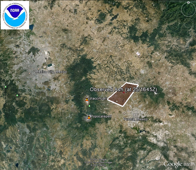 |
Figure 61. On 25 January 2012, the Washington VAAC released the mapped area and text details of observed airborne ash from Popocatépetl. A "short exhalation of ash" had reached an altitude of ~11 km. VAAC reports with graphics showing polygons that enclose inferred ash drift have been available for years, but those on Google Earth backgrounds are relatively new. Courtesy of the Washington VAAC. |
Activity escalated and peaked in April 2012. This report continues the table in the previous report (BGVN 36:11) that tallies ash emissions, and includes events such as incandescence and elevated seismic activity (table 22). Incandescence and numerous plumes of gas and ash were reported from December 2011 to April 2012. Events escalated later, on 13 April, when seismicity increased and explosions occurred at the summit. Blocks and incandescent ejecta exploded from the crater and fine ash from these events was reported in nearby towns. On 16 April CENAPRED announced that hazardous conditions had escalated and increased the Alert Level at the volcano from Yellow Phase 2 to Yellow Phase 3. Local news reported that the governor of Puebla, Rafael Moreno Valle, had announced that schools located within 12 km of Popocatépetl were closed. Significant ash emissions continued from April through June. On 18 April an explosion sent incandescent fragments over 800 m from the crater; that material covered snowy areas near the summit and formed small lahars (table 22). On 8, 10, and 12 May local news reported that the Puebla airport was closed due to volcanic ashfall.
 |
Table 22. Emissions and activity from Popocatépetl's summit crater between 14 December 2011 and 26 June 2012. Data provided by the Centro Nacional de Prevención de Desastres (CENAPRED). |
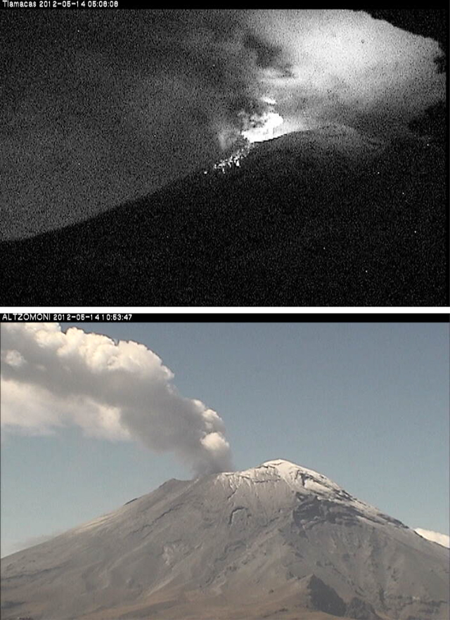 |
Figure 62. (top) Night glow and ejecta on the N flank of Popocatépetl on 14 May 2012; image taken at 0508 by the Tlamacas camera, which is located ~5 km N of the edifice. (bottom) A persistent gas-and-steam plume taken by the Altzomoni camera, located ~10 km to the NNW of Popocatépetl, at 1053. Courtesy of CENAPRED. |
MODVOLC Thermal Alerts. Elevated temperatures from the summit area of Popocatépetl have been detected regularly by satellite remote sensing, in particular, using the Geostationary Operational Environmental Satellite (GOES) and Earth Observing System (EOS) satellites (Wright and others, 2002; Wright and others, 2004). The ability to detect elevated temperatures varies significantly based on meteorological changes, cloud cover, and solar irradiance; volcanic explosions, however, have produced distinctive radiance signatures and have been reliably documented (Wright and others, 2002).
A study focused on 1998 thermal data from Popocatépetl highlighted the challenges unique to the remote sensing of lava domes (Wright and others, 2002). Investigators correlated the irregular appearance of thermal anomalies with physical changes at the dome. Seismic and SO2 gas flux data supported the conclusion that high thermal emissions followed explosions, "which served to disrupt the cool dome carapace and expose the much hotter interior to the orbiting sensor. Thus, it was not the presence of the dome itself that produced elevated levels of radiance but rather transient processes affecting its surface temperature."
A primary tool for monitoring volcano thermal emissions is the MODVOLC algorithm which was developed by the Hawaii Institute of Geophysics and Planetology (HIGP), in operation since 2002. The algorithm flags thermal anomalies that appear in data captured by the MODIS sensor (on EOS satellites Terra and Aqua) (Wright and others, 2004). The online archive of graphic and text results was designed to be updated, typically within 12 hours of each MODIS overpass. Since local fires, meteorological conditions, and eruption clouds influence the detection of thermal anomalies and cannot be quantified, investigators emphasize caution and awareness of local conditions when interpreting short-term (for example, day-to-day) thermal anomaly data at individual volcanoes.
From June 2011 through June 2012, ~230 thermal alert pixels were detected near the summit area of Popocatépetl with the MODVOLC system (figure 63). From October 2010 to June 2012, thermal anomalies were reported every month except for August 2011 (table 23). Generally 1-2 anomalies were detected in each report; on rare occasions 3-4 anomalies were detected. While CENAPRED has reported numerous ash and explosive events at the summit during this time period, meteorological conditions may have reduced thermal data acquisition during the rainy seasons (May through September).
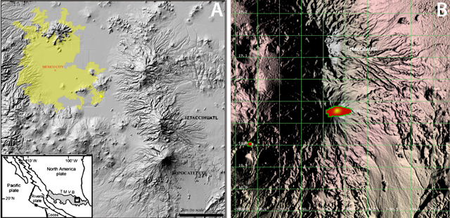 |
Figure 63. A) Locations of the Trans-Mexican Volcanic Belt (TMVB) including the location of Popocatépetl with relation to surrounding populated areas (Cross and others, 2012). B) Hotspots detected at Popocatépetl with the MODVOLC method from June 2011 through June 2012. Grid lines are 10 km between intersections. Each thermal pixel is one square kilometer. Pixels were concentrated around the summit region with one anomalous hotspot of clear non-volcanic origin located ~20 km SW. Courtesy of HIGP. |
Table 23. Monthly summary of thermal anomalies detected at Popocatépetl from October 2010 through June 2012. The number of reports for each month is based on the daily summaries available on the MODVOLC website and the number of pixels was counted from each report. Only pixels within a 10 km radius of the summit were included in this table. Courtesy of HIGP.
| Month | Number of reports | Total number of pixels |
| Oct 2010 | 15 | 16 |
| Nov 2010 | 13 | 13 |
| Dec 2010 | 27 | 37 |
| Jan 2011 | 22 | 34 |
| Feb 2011 | 14 | 20 |
| Mar 2011 | 15 | 18 |
| Apr 2011 | 13 | 17 |
| May 2011 | 11 | 13 |
| Jun 2011 | 3 | 3 |
| Jul 2011 | 1 | 1 |
| Aug 2011 | 0 | 0 |
| Sep 2011 | 6 | 6 |
| Oct 2011 | 12 | 13 |
| Nov 2011 | 14 | 20 |
| Dec 2011 | 23 | 39 |
| Jan 2012 | 21 | 32 |
| Feb 2012 | 9 | 13 |
| Mar 2012 | 21 | 41 |
| Apr 2012 | 15 | 26 |
| May 2012 | 16 | 28 |
| Jun 2012 | 6 | 8 |
References. Cross, J.K., Roberge, J., and Jerram, D.A., 2012. Constraining the degassing processes of Popocatépetl Volcano, Mexico: A vesicle size distribution and glass geochemistry study, Journal of Volcanology and Geothermal Research, 225?226: 81?95.
Wright, R., De La Cruz-Reyna, S., Flynn, L., Harris, A.J.L., and Gomez-Palacios, J.J., 2002. Infrared satellite monitoring of Popocatépetl: explosions, exhalations and cycles of dome growth, Journal of Geophysical Research, 107, B8, 2153.
Wright, R., Flynn, L.P., Garbeil, H., Harris, A.J.L., and Pilger, E., 2004. MODVOLC: near-real-time thermal monitoring of global volcanism. Journal of Volcanology and Geothermal Research, 135: 29-49.
Geological Summary. Volcán Popocatépetl, whose name is the Aztec word for smoking mountain, rises 70 km SE of Mexico City to form North America's 2nd-highest volcano. The glacier-clad stratovolcano contains a steep-walled, 400 x 600 m wide crater. The generally symmetrical volcano is modified by the sharp-peaked Ventorrillo on the NW, a remnant of an earlier volcano. At least three previous major cones were destroyed by gravitational failure during the Pleistocene, producing massive debris-avalanche deposits covering broad areas to the south. The modern volcano was constructed south of the late-Pleistocene to Holocene El Fraile cone. Three major Plinian eruptions, the most recent of which took place about 800 CE, have occurred since the mid-Holocene, accompanied by pyroclastic flows and voluminous lahars that swept basins below the volcano. Frequent historical eruptions, first recorded in Aztec codices, have occurred since Pre-Columbian time.
Information Contacts: Centro Nacional de Prevención de Desastres (CENAPRED), Av. Delfín Madrigal No.665. Coyoacan, México D.F. 04360, México (URL: https://www.gob.mx/cenapred/); Washington Volcanic Ash Advisory Center (VAAC), Satellite Analysis Branch (SAB), NOAA/NESDIS E/SP23, NOAA Science Center Room 401, 5200 Auth Rd, Camp Springs, MD 20746, USA (URL: http://www.ospo.noaa.gov/Products/atmosphere/vaac/); MODVOLC, Hawai`i Institute of Geophysics and Planetology (HIGP), MODVOLC Thermal Alerts System, School of Ocean and Earth Science and Technology (SOEST), Univ. of Hawai`i, 2525 Correa Road, Honolulu, HI 96822, USA (URL: http://modis.higp.hawaii.edu/); La Gran Epoca.com (URL: http://www.lagranepoca.com); Reuters (URL: http://www.reuters.com/resources/archive/us/2012.html).