Report on Tinakula (Solomon Islands) — June 2012
Bulletin of the Global Volcanism Network, vol. 37, no. 6 (June 2012)
Managing Editor: Richard Wunderman.
Tinakula (Solomon Islands) Recent observations on the volcano island
Please cite this report as:
Global Volcanism Program, 2012. Report on Tinakula (Solomon Islands) (Wunderman, R., ed.). Bulletin of the Global Volcanism Network, 37:6. Smithsonian Institution. https://doi.org/10.5479/si.GVP.BGVN201206-256010
Tinakula
Solomon Islands
10.386°S, 165.804°E; summit elev. 796 m
All times are local (unless otherwise noted)
Since our recent brief report on Tinakula (BGVN 37:02), the Bulletin received an informal report from Timothy McConachy of Neptune Minerals, Inc., containing observations of Tinakula volcano made 10 May 2012 (Cook and others, 2012). Most of the following information in the next few paragraphs was extracted from that report.
The location of Tinakula with respect to other islands in the Santa Cruz Islands is shown in figure 12; figure 13 shows geological details of the Tinakula volcanic island.
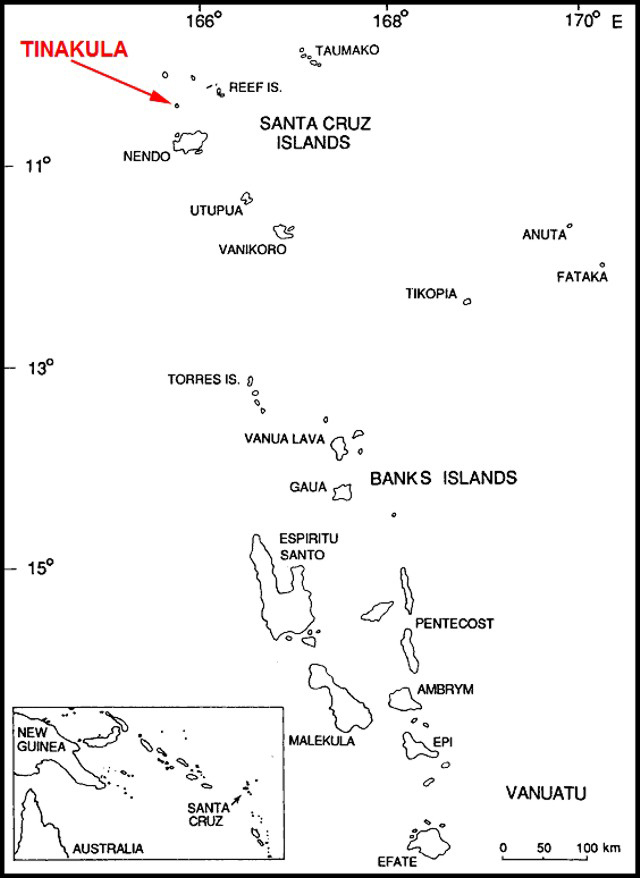 |
Figure 12. The location of Tinakula in the Santa Cruz Islands; inset area shows location of Santa Cruz Islands with respect to New Guinea and Australia. Courtesy of McCoy and Cleghorn (1988). This map previously appeared in BGVN 36:08. |
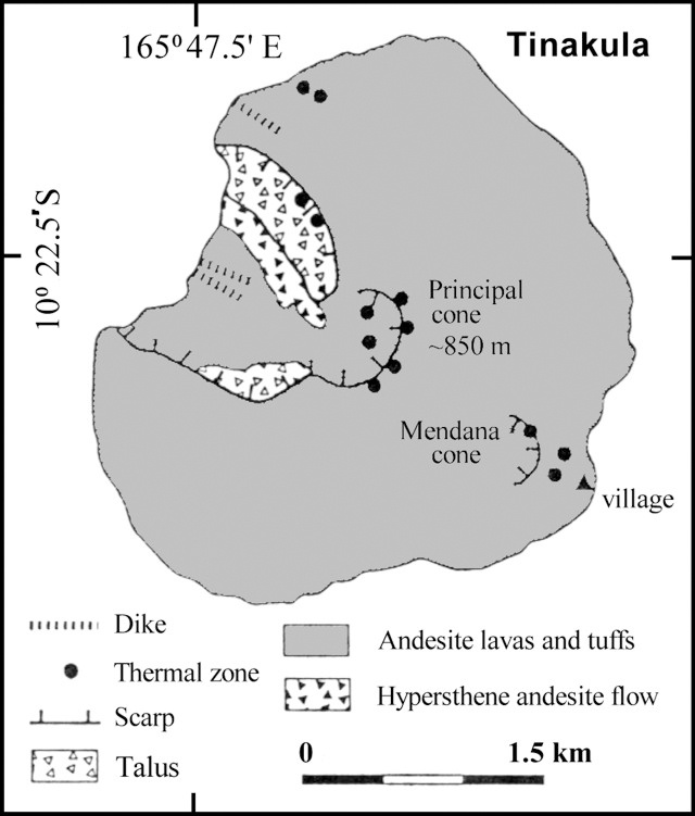 |
Figure 13. Sketch map of Tinakula island based on work and publications by G.W. Hughes (1972) and colleagues, and summarized by Eissen and others (1991). This figure previously appeared in BGVN 28:01 and 36:08. |
Visit to Tinakula. Cook and others (2012) twice circumnavigated Tinakula clockwise in a banana boat with a 40-horse-power engine in the afternoon on Thursday, 10 May 2012. The day was sunny and clear with minor clouds and a NE breeze which stiffened during the afternoon; cloud cover increased during the afternoon. During the 2 transits they observed recent land slides, the NW collapse area (shown on Figure 13), and steam/gas plumes. A highlight of the visit was when red incandescent boulders of lava bounced down the large scree slope (up to 200-m-wide and 600- to 800-m-long) in the NW collapse sector. As they bounced, the boulders broke into smaller fragments and puffs of stream/gas were seen making white dotted tracks, or 'vapour trails' (figure 14). A number of the fragments from the larger boulders made their way into the sea, and plumes of steam rose along with the splash. When the larger boulders rolled into the sea, the authors could hear thudding sounds as they hit the water, followed by a hissing sound. At times the splash would rise 2 m or higher when the boulders hit the sea. Some of the boulders and fragments did not roll into the sea, but sat on the edge of the water, steaming and hissing for some time (between 3-5 min) before they cooled off.
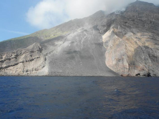 |
Figure 14. The main scree slope in the NW collapse sector of the volcano, photographed at 1416 hours on 10 May 2012. White patches of steam/gas ('vapour trails') were caused by boulders bouncing down the slope. Courtesy of Cook and others (2012). |
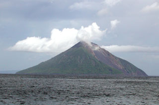
To the naked eye, there appeared to be a steady cloud above Tinakula (figure 15), quite visible even from the town of Lata (~35 km S of Tinakula, located on Graciosa Bay, Nendö Island - aka Ndende Island, the provincial capital of Temotu Province in the far eastern Solomon Islands). It was difficult for Cook and others (2012) to photograph the incandescent color of the boulders and it only became apparent on the second time around the volcano in the later part of the afternoon when the area was backlit by the sun. The boulders originated from an area obscured by steam and gas. When the authors turned the outboard motor off, they could hear rumbling and small explosions at times. The size of the boulders was difficult to judge, but they thought that the larger ones were the size of a small car. They were surprised to see coconut palms growing up the slopes on most sides of the volcano, up to 50 m above sea level, possibly planted by locals.
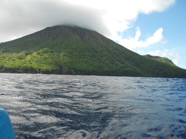 |
Figure 15. Cloud covering the summit of Tinakula at 1358 on 10 May 2012. The top of the volcano is virtually deforested. Courtesy of Cook and others (2012). |
Other comments. MODVOLC satellite thermal imagery continued to measure several thermal alerts almost daily.
References. Cook, H.J., Koraua, B.L., and McConachy, T.F., 2012, Observations of Tinakula Volcano, 10 May 2012, Solomon Islands (-10.38°S / 165.8°E), Informal report, 12 pp.
Eissen, J-P., Blot, C., and Louat, R., 1991, Chronology of the historic volcanic activity of the New Hebrides island arc from 1595 to 1991: Rapports Scientifiques et Technique, Sciences de la Terre, No. 2, ORSTOM, France.
Hughes, G.W., 1972, Geological map of Tinakula: Nendö sheet EOI 1, Soloman Geol. Survey, Honiara.
McCoy, P.C., and Cleghorn, 1988, Archaeological Excavations on Santa Cruz (Nendö), Southeast Solomon Islands: Summary Report, pp. 104-115; in Archaeology in Oceania.
Geological Summary. The small 3.5-km-wide island of Tinakula is the exposed summit of a massive stratovolcano at the NW end of the Santa Cruz islands. It has a breached summit crater that extends from the summit to below sea level. Landslides enlarged this scarp in 1965, creating an embayment on the NW coast. The Mendana cone is located on the SE side. The dominantly andesitic volcano has frequently been observed in eruption since the era of Spanish exploration began in 1595. In about 1840, an explosive eruption apparently produced pyroclastic flows that swept all sides of the island, killing its inhabitants. Recorded eruptions have frequently originated from a cone constructed within the large breached crater. These have left the upper flanks and the steep apron of lava flows and volcaniclastic debris within the breach unvegetated.
Information Contacts: Timothy F. McConachy, Neptune Minerals, Inc. (URL: http://www.neptuneminerals.com); Brent McInnes, Commonwealth Scientific and Industrial Research Organisation (CSIRO), Australia (URL: http://www.csiro.au); MODVOLC, Hawai’i Institute of Geophysics and Planetology (HIGP) Thermal Alerts System, School of Ocean and Earth Science and Technology (SOEST), Univ. of Hawai’i, 2525 Correa Road, Honolulu, HI 96822, USA (URL: http://modis.higp.hawaii.edu/).