Report on Masaya (Nicaragua) — June 2012

Bulletin of the Global Volcanism Network, vol. 37, no. 6 (June 2012)
Managing Editor: Richard Wunderman.
Edited by Julie A. Herrick.
Masaya (Nicaragua) Explosions from Santiago crater began on 30 April 2012
Please cite this report as:
Global Volcanism Program, 2012. Report on Masaya (Nicaragua) (Herrick, J.A., and Wunderman, R., eds.). Bulletin of the Global Volcanism Network, 37:6. Smithsonian Institution. https://doi.org/10.5479/si.GVP.BGVN201206-344100
Masaya
Nicaragua
11.9844°N, 86.1688°W; summit elev. 594 m
All times are local (unless otherwise noted)
Since our last report covering Masaya's seismic activity and emissions from November 2011 through March 2012, the Instituto Nicaragüense de Estudios Territoriales (INETER) has maintained monitoring efforts including site visits in April and May 2012. Here we discuss regular gas emissions (SO2 and CO2) and seismic monitoring efforts and highlight events preceding the 30 April 2012 explosion from Santiago crater that ejected ash and incandescent blocks within the bounds of the National Park. That event began a series of explosions; more than 68 explosions occurred between 30 April and 17 May 2012.
On 21 April 2012 INETER conducted routine site visits and made field measurements at Masaya. Maximum temperatures recorded with an infrared sensor found temperatures between 98.7°C and 102°C within Santiago crater. Some jetting sounds were heard from the depths of the crater, cracks were observed on the E wall that emitted abundant gases, and the W interior wall showed signs of rockfalls. INETER field teams also visited Comalito cone, located on the NE flank, and measured maximum temperatures of 72°C to 77°C.
During field investigations on 25 April 2012, INETER volcanologists measured diffuse CO2 emissions from Comalito cone. At night on 26 April, the National Park guards reported incandescence within the crater; the last report of incandescence was in October 2010 (BGVN 36:11). SO2 was measured with Mobile DOAS on 27 April on a traverse between the towns Ticuantepe and La Concha (see map for location in figure 25 from BGVN 36:11).
INETER reported that, on 27 April 2012 at approximately 0500 volcanic tremor appeared in Masaya's seismic records (figure 34). Tremor slowly increased to 70 RSAM that day, and civil defense authorities released notices to officials that significant seismic unrest was detected at Masaya.
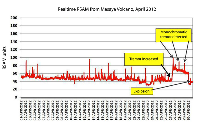 |
Figure 34. RSAM (averaged seismic amplitude) record from Masaya volcano during April 2012, an interval leading up to and including a 30 April eruption. Tremor drove a notable increase in RSAM on 27 April, diminishing slightly as monochromatic tremor prevailed over the following days. After an abrupt decrease in RSAM, the eruption occurred on 30 April. Courtesy of INETER. |
On 28 April 2012, authorities, including the Masaya Volcano National Park, released a public announcement about the unusual seismic activity. Three hours following that announcement, the tremor signal became monochromatic near 15 Hz (figure 35). INETER suggested that this signal arose from magma moving beneath the edifice. RSAM reached 100 units with spectral analysis indicating frequencies oscillating between ~1.26 Hz and ~18.84 Hz. The strongest frequency during one particular time window (figure 35) was centered near 15.8 Hz, with a smaller peak at ~1.5 Hz.
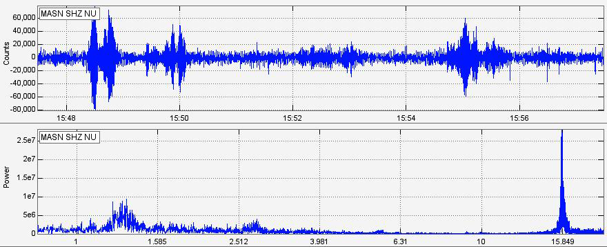 |
Figure 35. (Upper panel) Seismic signal dominated by ongoing tremor recorded at Masaya on 28 April 2012 on a seismogram (amplitude, y-axis, and time (hours : minutes), x-axis). (Lower panel) A spectral analysis made for the interval shown above (frequency, in Hz, along x-axis). Courtesy of INETER. |
INETER noted that before the onset of tremor on 27 April, an average of 35 seismic events per day were recorded. These were low frequency earthquakes that included signals reaching 16 Hz and interpreted as rupture events beneath Masaya. The depths of the earthquakes were determined by the P- and S-wave arrival times indicating a depth range between 3 and 4 km.
On 28 April, tremor continued at 70 RSAM and monochromatic tremor occurred again, reaching 90 RSAM. Up to 40 earthquakes were detected that day.
On 29 April, seismic tremor was slightly lower at 65 RSAM and monochromatic tremor was recorded. A total of 45 earthquakes were recorded. Signals were again monochromatic at peak frequencies of 15.8 Hz.
On 30 April at 0045, the tremor signal dramatically decreased to 30 RSAM. INETER commented that this was abnormal since tremor was often recorded between 40 and 50 RSAM during times of quiescence. Seven hours later, a strong explosion was recorded by seismic instruments and observers within the National Park witnessed a blast of gas and ash from Santiago crater (figure 36).
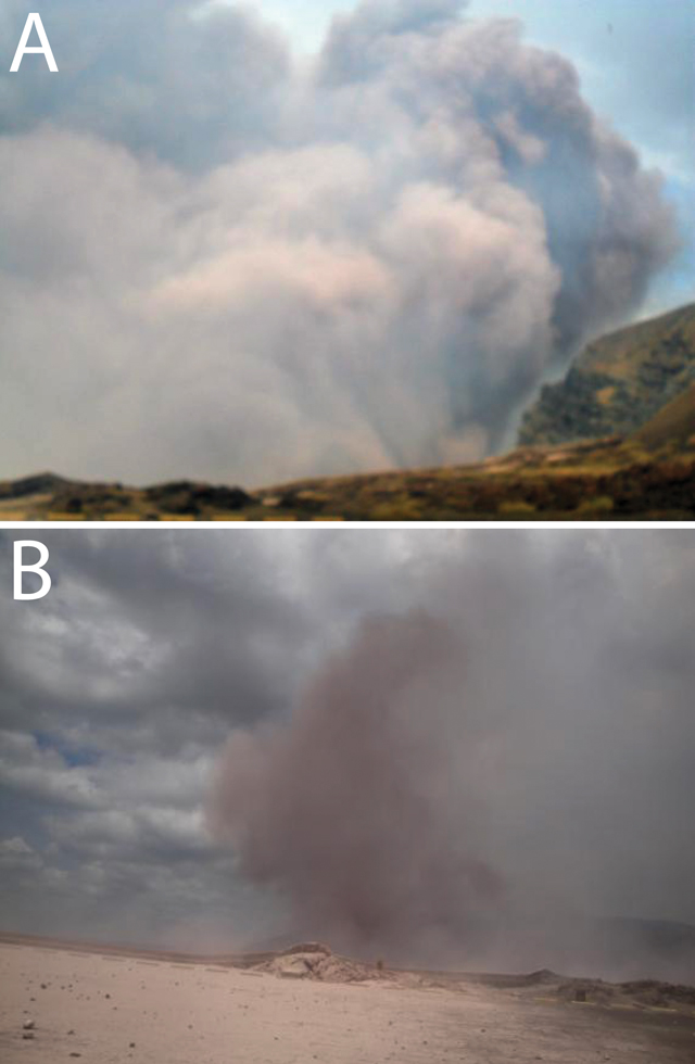 |
Figure 36. Ash explosions began on 30 April 2012 from Masaya's Santiago crater. (A) A large explosion occurred at 0829 on 30 April and was photographed by National Park staff. (B) Later in the day a smaller explosion released a small ash plume. Courtesy of INETER and the Masaya Volcano National Park. |
Due to the explosions, the Plaza de Oviedo, an overlook at the edge of Santiago crater, was covered with sand-sized pink and yellow ash and lapilli with some rocks up to 10 cm in diameter. Some of the clasts were incandescent and damaged the roofs of structures near the crater and also burned the asphalt of the plaza (figure 37). Small brush fires were ignited on the N flank of the volcano due to hot blocks falling onto the dry plants. Local firefighters worked with the National Park and Civil Defense for most of the day in order to contain and extinguish the fires. The national park was closed due to the hazardous conditions.
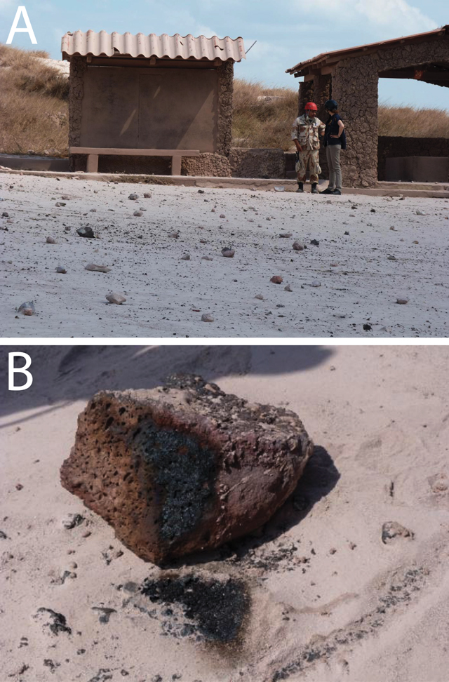 |
Figure 37. (A) The roofs of several structures near Santiago crater were damaged by volcanic bombs during the 30 April 2012 explosions. (B) Some of the bombs ejected during the primary explosion were incandescent and burned the asphalt of the plaza when they landed. Courtesy of INETER. |
INETER reported the explosion ejected a column of ash, gas, and blocks reaching 1,000 m above the summit and the initial explosion was followed by 24 smaller explosions that reached 500 m. Ballistic ejecta covered an area with a 300 m radius to the SSE of the crater and ash fell as far as 3 km to the SE of the crater. Blocks measured from this area had maximum dimensions of 50 x 40 x 30 cm. Ash fell to a thickness of 2 mm in some areas and INETER calculated a total volume of 736 cubic meters of ejecta.
INETER measured temperatures from Santiago crater on 30 April with an infrared thermal camera and detected a maximum of 165°C. During the night of 30 April, 23 explosions were recorded by the seismic network.
Between 30 April and 3 May, a collaborative effort among INETER, Civil Defense, local fire fighters, and the National Park succeeded in maintaining a 24-hour watch of Santiago crater. Over four days, the teams recorded observations and determined that 68 explosions had occurred and the maximum detected crater temperature was 162°C.
On 1 May 2012 at 0223 a small explosion was recorded by the INETER seismic network. This event produced ash and volcanic bombs that fell across the NE-SE sectors including the flanks of Nindirí cone (see figure 30 in BGVN 37:04 for site names). The dimensions of the largest blocks were 60 x 50 x 40 cm.
On 3 May there were two small explosions at 0008 and 0022 with abundant gas and ash emissions. Throughout these events, tremor was constant at 1.5 Hz. On 4 May no earthquakes were recorded but tremor remained between 45 and 50 RSAM; explosions of gas and light ash were observed. On 5 May a total of 19 earthquakes were recorded and RSAM varied between 45 and 58 RSAM; ash and gas explosions were reported by National Park staff. On 6 May between 0700 and 1030 a total of 45 earthquakes were recorded and RSAM increased to 70 units.
Sporadic explosions continued until mid-May (figure 38). INETER noted that in May, RSAM averaged 60 units and a significant increase occurred on 18 May. RSAM reached 120 units and was maintained at that level until 21 May. Low tremor was recorded up to 75 RSAM units after 21 May and two days later reached 85 RSAM units with frequencies in the range 1.5-3.0 Hz. Tremor decreased and remained between 65 and 70 RSAM units until the end of the month. A total of 266 earthquakes were recorded in May.
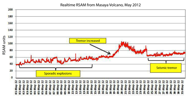 |
Figure 38. RSAM record from Masaya volcano during May 2012. Courtesy of INETER. |
Long-term gas monitoring. Long-term records of Masaya's gas emissions (SO2 and CO2) and fumarole temperatures have been developed by INETER. On 2 May, SO2 flux was measured during traverses between Ticuantepe and La Concha (table 5). INETER commented that they observed increasing SO2 flux since December 2011 (648 tons per day) that peaked in March 2012 (1002 tons per day). Flux was decreasing at the time of the explosion on 30 April 2012. INETER noted that overall trends in SO2 flux did not correlate with trends in seismicity, however, they emphasized that difficult-to-constrain variables such as wind speed and direction should be factored into the SO2 data interpretations.
Table 5. SO2 flux detected at Masaya from January 2011 through May 2012 during traverses with a Mobile DOAS. Courtesy of INETER.
| Month | SO2 flux (tons/day) |
| Jan 2011 | 642 |
| Sep 2011 | 518 |
| Oct 2011 | 153 |
| Dec 2011 | 648 |
| Jan 2012 | 801 |
| Feb 2012 | 943 |
| Mar 2012 | 1002 |
| Apr 2012 | 761 |
| May 2012 | 534 |
Since 7 December 2008, INETER measured CO2 emissions from Comalito cone, an active fumarolic site on the NE flank of Masaya. Diffuse CO2 was measured from a 9 hectare sector of soil as recently as 1 May 2012 (table 6). INETER reported the highest CO2 emissions were detected in 2008 and decreased between 2010 and 2011. Emissions recorded on 25 April 2012 (before the eruption) were considered low, however, there was a small peak on 1 May that may have been related to the explosive activity.
Table 6. The long-term record of diffuse CO2 analyses from Comalito cone measured from September 2008 through May 2012. Courtesy of INETER.
| Date | Area (km2) | CO2 emission (tons/day) |
| 07 Dec 2008 | 0.09 | 66.4 |
| 26 Mar 2010 | 0.09 | 27.4 |
| 02 Mar 2011 | 0.09 | 15.1 |
| 30 Jan 2012 | 0.09 | 50.8 |
| 25 Apr 2012 | 0.09 | 25.2 |
| 01 May 2012 | 0.09 | 32.2 |
On 17 May, INETER conducted fieldwork at Santiago crater and determined a maximum temperature of 162°C. While in the field, INETER staff observed two small explosions from the crater. Temperatures were also measured at Comalito cone (figure 39); the maximum recorded temperature was from Fumarole 2, 78.2°C, the highest temperature reading at Comalito cone since February 2012.
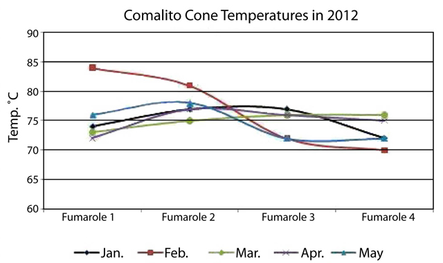 |
Figure 39. Temperatures measured at Comalito cone from January through May 2012. Courtesy of INETER. |
New monitoring efforts and installations. Two seismic stations were installed in May 2012. One station, called La Azucena, was installed by INETER on 1 May. This site was located ~4 km N of the active crater and was considered temporary. A second station, called El Comalito, was installed on 15 May; located within the National Park at Comalito cone. INETER recognized potential contributions of background noise from the fumarolic sites close to the station and planned to reevaluate the location after reviewing the results from this station. Both stations transmitted realtime data through radio repeaters.
On 4 May a web camera was installed within the town of La Azucena on a short tower; the camera was programmed to send images through a wireless network every 5 minutes. A second camera was installed in the town of Masaya at the office building of the Center of Disaster Operations (CODE); this camera also captured images every 5 minutes. The camera at CODE suffered malfunctions after installation due to overexposure from direct sunlight. Future fieldwork was planned to fix these problems.
Geological Summary. Masaya volcano in Nicaragua has erupted frequently since the time of the Spanish Conquistadors, when an active lava lake prompted attempts to extract the volcano's molten "gold" until it was found to be basalt rock upon cooling. It lies within the massive Pleistocene Las Sierras caldera and is itself a broad, 6 x 11 km basaltic caldera with steep-sided walls up to 300 m high. The caldera is filled on its NW end by more than a dozen vents that erupted along a circular, 4-km-diameter fracture system. The Nindirí and Masaya cones, the source of observed eruptions, were constructed at the southern end of the fracture system and contain multiple summit craters, including the currently active Santiago crater. A major basaltic Plinian tephra erupted from Masaya about 6,500 years ago. Recent lava flows cover much of the caldera floor and there is a lake at the far eastern end. A lava flow from the 1670 eruption overtopped the north caldera rim. Periods of long-term vigorous gas emission at roughly quarter-century intervals have caused health hazards and crop damage.
Information Contacts: Instituto Nicaragüense de Estudios Territoriales (INETER), Apartado Postal 2110, Managua, Nicaragua (URL: http://www.ineter.gob.ni/); La Prensa (URL: http://www.laprensa.com.ni/).