Report on Turrialba (Costa Rica) — June 2012

Bulletin of the Global Volcanism Network, vol. 37, no. 6 (June 2012)
Managing Editor: Richard Wunderman.
Turrialba (Costa Rica) New fumarolic vent opens on the SW flank of the W crater on 12 January 2012
Please cite this report as:
Global Volcanism Program, 2012. Report on Turrialba (Costa Rica) (Wunderman, R., ed.). Bulletin of the Global Volcanism Network, 37:6. Smithsonian Institution. https://doi.org/10.5479/si.GVP.BGVN201206-345070
Turrialba
Costa Rica
10.025°N, 83.767°W; summit elev. 3340 m
All times are local (unless otherwise noted)
Turrialba is the eastern-most of Costa Rica's active volcanoes, located 65 km E of the capitol, San Jose. The previous Bulletin report discussed frequent degassing and occasional ashfall between March 2010-June 2011 (BGVN 36:09). This report discusses activity between July 2011 and May 2012.
A recent comprehensive report prepared by Observatorio Vulcanológico y Sismológico de Costa Rica-Universidad Nacional (OVSICORI-UNA) provides an excellent background: "Since May 1996, Turrialba volcano has shown an important increase in activity, which can possibly be interpreted as precursory of a new eruptive phase. The volcano-tectonic activity and degassing increase is particularly noticeable since 2007, and even more since the opening of the first fumarolic vent in the W crater [the main crater 'pLa Quemada'] in January 2010, which suggested a magmatic intrusion between 2005 and 2007 as well as the beginning of a new eruptive phase. A new vent opened on January 12th, 2012 (Boca 2012 or 2012 vent) on the southeast external flank of the W crater, with few hours of ash emission, followed by a second ash emission from the same vent on January 18th, 2012." A chronology of events leading up to the 12 January 2012 event is shown in table 6.
Table 6. Events since 1996 leading up to the 12 January 2012 vent opening event, and associated previous Bulletin coverage. Dates and event descriptions courtesy of OVSICORI-UNA.
| Date | BGVN report(s) | Remarks |
| 1996 | 21:06 (Jun 1996), 21:08 (Aug 1996), 21:12 (Dec 1996) | During the first four months of 1996 nearly no events were registered. After 23 May Turrialba registered a sudden increase in microseismicity. In late May there were over 50 events; in June, 246 events. During July, observers witnessed weak fumarolic activity continuing along the NE, N, W, and S sides of the crater which included 146 local earthquakes. In August, 299 local earthquakes were detected. |
| 2001 | 26:11 (Nov 2001) | Seismic swarms and increase in the fumarolic activity with the appearance of magmatic gases. |
| 2003-2005 | 32:08 (Aug 2007) | Seismic swarms and increase in the fumarolic activity with the appearance of magmatic gases. |
| 2007 | 32:08 (Aug 2007) | Seismic swarms and increased fumarolic activity at the bottom of the W crater, forming a plume up to 2 km height. |
| 2007-2012 | 33:01 (Jan 2008), 34:09 (Sep 2009) | Increase in the fumarolic activity with a strong magmatic component and high temperatures. |
| 5-6 Jan 2010 | 35:02 (Feb 2010) | Phreatic eruption and opening of the 2010 vent on the W flank inside the W crater accomanied by ash emission. |
| 14 Jan 2010 | -- | Small ash emission. |
| Early 2011 | 36:09 (Sep 2011) | "Roaring" sound from the vent located on the N side of the W Crater. This vent may have opened at the beginning of the rainy season, around May 2011; no confirmation possible. |
| 12 Jan 2012 | Current report | Opening of the 2012 vent on the SE flank of the W crater accompanied by an ash emission. |
Seismicity at Turrialba from early November through December 2011 was variable with event frequency ranging from as low as 20 events per day to an occasional high of 80 events per day. The frequency of events dropped significantly in early December to generally less than 60 per day until there was a dramatic increase on 31 December when 155 seismic events were recorded. Event frequency in early January 2012 showed a steady increase from 40 events per day reaching about 80-100 events per day between 6 and 13 January.
Eruption on 12 January 2012. After midnight on 9 January 2012, residents of the Central Valley heard booming and crashing sounds. Investigators at OVSICORI-UNA reviewed the seismic records but did not find associated seismic or volcanic activity. On 11 January, residents again reported several instances of rumbling. On 12 January, OVSICORI-UNA reported that a new vent, located on the SE flank of the volcano's W crater had opened. According to OVSICORI-UNA, the new vent exhibited "a vigorous output of bluish gas at high temperature (T > 592°C) that generated a jet-like sound audible from the visitor lookout." This activity included a few hours of ash emission. A second ash emission from the same vent occurred on 18 January (see subsection below). Seismic recordings, deformation, and diffused gas flux measurements allowed the conclusion that the opening of the 2012 fumarolic vent is not due to a change in the magmatic activity but to an excessive shallow accumulation of gas. This conclusion is substantiated by information obtained from a network of Electronic Distance Measurement (EDM) equipment using five reference points (prisms) which have been taking measurements since 2009. No significant variations of the distance relationships that would coincide with the ash emissions of 2010 and 2012 had been noted. EDM data after March 2011 showed a decrease in measured distances, mainly in the N direction with small variations in the other directions. This information is considered corroborated by Global Position System (GPS) data provided by two GPS stations which show a small but continuous trend of decreasing distance observed during April 2010-January 2012.
Similar vent openings occurred at Turrialba prior to the 1864-66 eruption and at Irazú volcano prior to its 1963-65 eruption. Hence, other openings of fumarolic vents can be expected in the future, especially along the fractures and weak zones aligned in a SW-NE direction that passes by the three upper craters of Turrialba.
The activity of 12 January was a pressure release on the SE flank of the W crater. OVSICORI-UNA considered the release to have penetrated weakened rock, not a magmatic or phreatic (steam-driven) eruption. (The rock at the summit of Turrialba is considered to be very weak due to the intense rainfall and the persistent hydrothermal activity at the summit. This weakness facilitates the development of vents.) An ash plume rose ~500 m above the crater and drifted NNE and NNW, rising to an altitude of ~4 km. Later that day residents reported a dark plume coming from the main crater and a white vapor plume that rose from the fumarolic vent which had formed in the main crater on 5 January 2010. The emissions caused OVSICORI-UNA to raise the Alert Level to Yellow in the communities of La Central (34 km SW), Santa Cruz (7 km SE), and around the perimeter of the crater. Towns of Jiménez (21 km N), Oreamuno (45 km SW), Alvarado (38 km SW), and Cartago (25 km SW) remained at Alert Level Green. Ashfall was reported in Tres Ríos (27 km SW).
Gas emission analysis the day before the opening of the 2012 vent (11 January) showed high values of CO2 and H2S over the entire E flank of the W crater. A 115-m-long liquid sulfur flow was observed in the main crater from the E side of W crater.
Eruption on 18 January 2012. During the evening of 18 January 2012, scientists observed gas emissions and ejection of tephra from the vent. They also observed reddish flames from combusting gas, estimated to be ~700°C. Degassing of Turrialba is considered a normal ongoing activity. An OVSICORI-UNA pilot observed an ash plume that rose to altitudes of ~4.3-6.1 km.
The seismogram from the 18 January eruption (figure 26) showed strong tremor coincident with the tephra and gas emissions. The tremor, which started at 1455, was most intense between 1502 and 1610 according to OVSICORI-UNA. Figure 26a shows >5,000 seconds of the most intense part of the tremor having significant variations in amplitude, especially at the beginning of the activity. Figure 26c shows the signal's frequency content over the same interval, with the highest normalized amplitudes having peaks between 5 and 15 Hz.
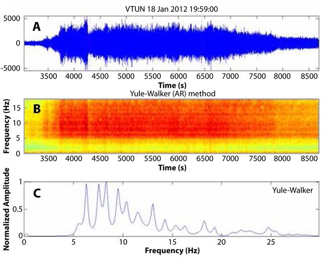 |
Figure 26. (a) A seismic recording for Turrialba on 18 January 2012 at station VTUN showing the most intense phase of the tremor that prevailed during the eruption that day. (b) Spectrogram of the seismicity shown in (a). (c) Normalized frequency spectrum of the seismic signal; the main peaks are between 5 and 15 Hz. Courtesy of OVSICORI-UNA. |
A false color satellite image of Turrialba taken on 21 January 2012 highlights ongoing impacts to vegetation from high gas emissions (figure 27). One of the concerns of the government is the amount of acid rain that has fallen on the region surrounding Turrialba. The acid rain, with a pH as low as 3.2, has degraded the local agricultural and livestock economy.
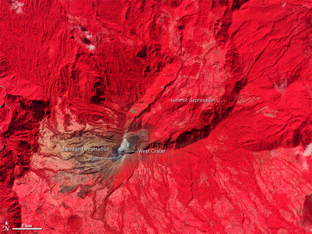 |
Figure 27. A false-color satellite image of Turrialba (a combination of near infrared, red, and green light) acquired on 21 January 2012. Healthy vegetation appears bright red, while vegetation damaged by years of acidic gas emissions is brown. Bare ground in the summit craters is brown or gray. This image was acquired by NASA's Advanced Spaceborne Thermal Reflecton and Emission Radiometer (ASTER) instrument aboard the TERRA satellite. Courtesy of NASA Earth Observatory. |
Vent incandescence in February 2012. A nocturnal visit to the W crater by volcanologists from OVSICORI-UNA on 2 February revealed several incandescent spots. Figure 28 (a view from the overlook taken on 9 February), shows a panoramic view of vent locations in relation to the West, Central, and East Craters. Each vent had different gas and vapor output, and different incandescence intensities. The 2012 vent, which opened on 12 January, registered temperatures above 700°C on 22 February. Continued degassing was noted in conjunction with incandescent spots at several locations on the W crater (figure 29).
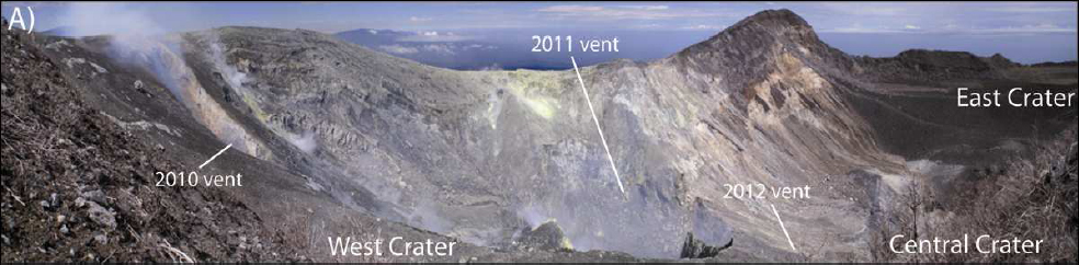 |
Figure 28. A panoramic view of the relative locations of the three vents which have been the sites of activity since 2010. Courtesy of OVSICORI-UNA. |
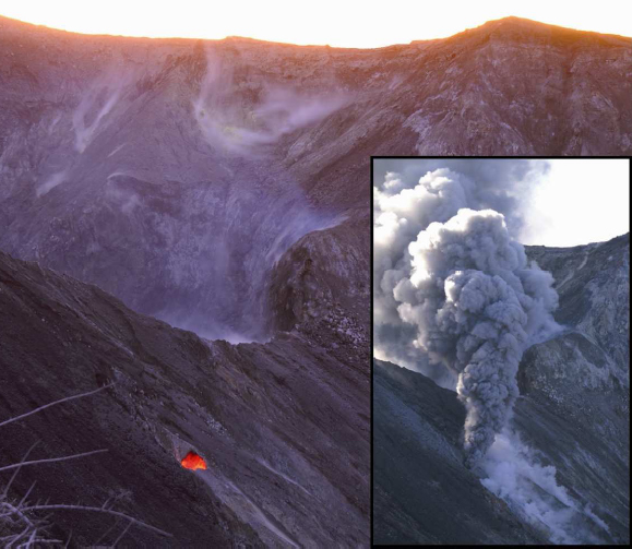 |
Figure 29. A view of the 2012 vent from the overlook taken on 9 February 2012. The insert on the right is the second ash emission from the 2012 vent on 18 January. Courtesy of G. A. Avard, OVSICORI-UNA. |
Geological Summary. Turrialba, the easternmost of Costa Rica's Holocene volcanoes, is a large vegetated basaltic-to-dacitic stratovolcano located across a broad saddle NE of Irazú volcano overlooking the city of Cartago. The massive edifice covers an area of 500 km2. Three well-defined craters occur at the upper SW end of a broad 800 x 2200 m summit depression that is breached to the NE. Most activity originated from the summit vent complex, but two pyroclastic cones are located on the SW flank. Five major explosive eruptions have occurred during the past 3500 years. A series of explosive eruptions during the 19th century were sometimes accompanied by pyroclastic flows. Fumarolic activity continues at the central and SW summit craters.
Information Contacts: Avard G., Pacheco J., Fernández E., Martínez M., Menjívar E., Brenes J., van der Laat R., Duarte E., Sáenz W., Observatorio Vulcanológico y Sismológico de Costa Rica-Universidad Nacional (OVSICORI-UNA), Apartado 86-3000, Heredia, Costa Rica (URL: http://www.ovsicori.una.ac.cr/); Washington Volcanic Ash Advisory Center (VAAC), Satellite Analysis Branch (SAB), NOAA/NESDIS E/SP23, NOAA Science Center Room 401, 5200 Auth Rd, Camp Springs, MD 20746, USA (URL: http://www.ospo.noaa.gov/Products/atmosphere/vaac/); Tico Times (URL: http://www.ticotimes.net/); Reuters (URL: http://www.reuters.com/); NASA Earth Observatory (URL: http://earthobservatory.nasa.gov/).