Report on Kirishimayama (Japan) — July 2012

Bulletin of the Global Volcanism Network, vol. 37, no. 7 (July 2012)
Managing Editor: Richard Wunderman.
Edited by Robert Dennen.
Kirishimayama (Japan) Gradual decline in activity following explosive 2011 eruptions
Please cite this report as:
Global Volcanism Program, 2012. Report on Kirishimayama (Japan) (Dennen, R., and Wunderman, R., eds.). Bulletin of the Global Volcanism Network, 37:7. Smithsonian Institution. https://doi.org/10.5479/si.GVP.BGVN201207-282090
Kirishimayama
Japan
31.934°N, 130.862°E; summit elev. 1700 m
All times are local (unless otherwise noted)
The early 2011 eruption of Shinmoe-dake (Shinmoedake) volcano of the Kirishima Volcanic Group was characterized by sub-Plinian and Vulcanian explosions and an ~600-m-diameter lava dome that was extruded into the crater (BGVN 35:12 and 36:07, reports covering through July 2011). Fewer eruptions occurred during an ensuing decline in activity, where plumes only rose to up to 1 km above the summit. No explosions (defined as accompanying an air shock larger than 20 Pa and explosive earthquake signals) were reported by the Japan Meteorological Agency (JMA) after 11 May 2011 and through June 2012. This report discusses diminishing plume emissions and seismicity during September 2011-June 2012, and supplies more context on the entire eruptive episode. The material in this report is based on JMA monthly reports, which are now available in English with coverage starting in October 2010.
2011 eruption wanes. After the explosive eruptions during January-February 2011, eruptions (ash emissions) at Shinmoe-dake occurred through 7 September 2011. After that, JMA reported no further eruptions at least through June 2012; gas-and-steam plumes rose to a maximum of ~600 m above the crater of Shinmoe-dake after 7 September 2011 (figure (18).
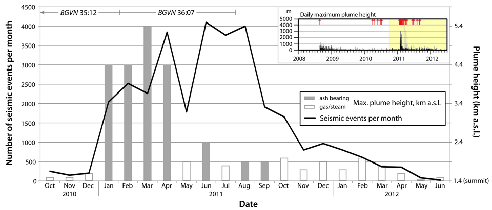 |
Figure 18. Plume behavior and seismicity at Kirishima during intervals bracketing the explosive activity of January-May 2011. The inset plot shows daily maximum plume heights (black bars, in meters above the summit) and eruptions (red arrows) since 2008, with the yellow shaded area indicating the temporal coverage of the main plot. The main plot shows maximum plume heights per month (kilometers above sea level, km a.s.l., right axis, where gray bars indicate months in which plumes contained ash, and white bars indicate months in which ash was absent in all plumes) and seismicity (seismic events per month, black line, left axis). Coverage of previous Bulletin reports is indicated at the top of the plot. Data and inset plot courtesy of JMA. |
Elevated seismicity continued following the cease of explosive eruptions in May 2011, but a substantial protracted decline too place during August-November 2011. In May and June 2012, JMA reported that seismicity had returned to background levels seen prior to the onset of the early 2011 explosive activity, and they reported an absence of measured tremor over the same two months (figures 18 and 19).
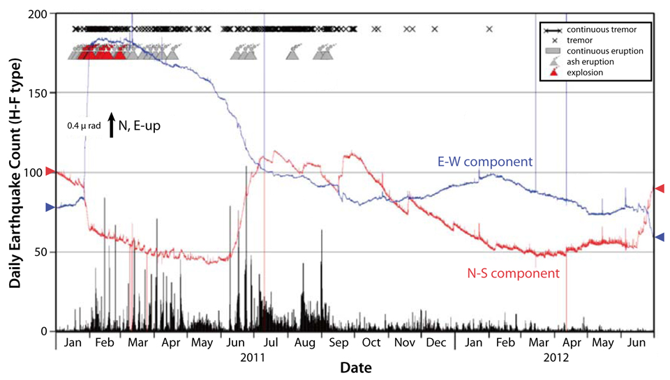 |
Figure 19. Kirishima's daily high-frequency (H-F) earthquake counts plotted with tilt measurements (E-W component shown in blue, N-S component shown in red), indications of tremor (black x's, top), ash eruptions (gray volcano symbols) and explosions (red volcano symbols) during January 2011-June 2012 at Shinmoe-dake. The black arrow indicates a tilt change of 4 microradians (µrad); the blue (E-W) and red (N-S) triangles indicate the start and end points of the tilt component records. Courtesy of JMA. |
JMA reported that GPS baseline extension indicated "magma supply to a deeper chamber several kilometers northwest of the crater" through December 2011; the baseline extension slowed after December. JMA initially reported almost no change after January 2012, but during June 2012 the baseline distance between Ebino (~16 km NNW) and Makizono (~14 km WSW) shortened.
Observation flights conducted through various collaborations between the Japan Ground, Air, and Maritime Self-Defense Forces (JGSDF, JASDF, and JMSDF, respectively) and the Ministry of Land, Infrastructure, Transportation and Tourism (MLIT) allowed frequent aerial photography and infrared thermal measurements of the crater and edifice of Shinmoe-dake. The diameter of the lava dome within the crater remained ~600 m as of June 2012 (indicating little-to-no growth since 30 January 2011). Infrared thermal photography revealed little thermal structure to the dome, but highlighted comparatively high-temperature areas at its margins. A fissure (described as a "crack" by JMA) located on the W slope of the edifice was occasionally reported to emit plumes, and exhibited an elevated temperature compared with the rest of the edifice (figure 20). Similar aerial and thermal observations were reported as late as 10 May 2012.
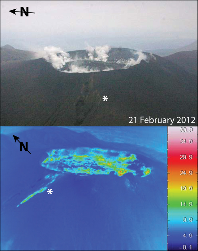 |
Figure 20. Aerial photograph (top) and infrared thermal image (bottom) of the summit of Shinomoe-dake volcano on 21 February 2012, illustrating a high-temperature anomaly that occurred within a fissure (described as a "crack" by JMA) on the W slope, where plumes were occasionally observed (labeled with '*'). For orientation, the same symbol is placed just S of the same approximate location in the aerial photo (top). Courtesy of JMSDF, MLIT, and JMA. |
The Alert Level remained at 3 (on a scale from 1-5) at the end of June 2012.
Geological Summary. Kirishimayama is a large group of more than 20 Quaternary volcanoes located north of Kagoshima Bay. The late-Pleistocene to Holocene dominantly andesitic group consists of stratovolcanoes, pyroclastic cones, maars, and underlying shield volcanoes located over an area of 20 x 30 km. The larger stratovolcanoes are scattered throughout the field, with the centrally located Karakunidake being the highest. Onamiike and Miike, the two largest maars, are located SW of Karakunidake and at its far eastern end, respectively. Holocene eruptions have been concentrated along an E-W line of vents from Miike to Ohachi, and at Shinmoedake to the NE. Frequent small-to-moderate explosive eruptions have been recorded since the 8th century.
Information Contacts: Japan Meteorological Agency (JMA), Otemachi, 1-3-4, Chiyoda-ku Tokyo 100-8122, Japan (URL: http://www.jma.go.jp/); Japan Ground Self-Defense Force (JGSDF) (URL: http://www.mod.go.jp/gsdf/english/index.html); Japan Air Self-Defense Force (JASDF) (URL: http://www.mod.go.jp/asdf/English_page/organization/formation01/); Japan Maritime Self-Defense Force (JMSDF) (URL: http://www.mod.go.jp/msdf/formal/english/index.html); Ministry of Land, Infrastructure, Transportation and Tourism (MLIT) (URL: http://www.mlit.go.jp/en/index.html).