Report on San Cristobal (Nicaragua) — August 2012

Bulletin of the Global Volcanism Network, vol. 37, no. 8 (August 2012)
Managing Editor: Richard Wunderman.
Edited by Julie A. Herrick.
San Cristobal (Nicaragua) Monitoring efforts and 8 September 2012 explosive eruption
Please cite this report as:
Global Volcanism Program, 2012. Report on San Cristobal (Nicaragua) (Herrick, J.A., and Wunderman, R., eds.). Bulletin of the Global Volcanism Network, 37:8. Smithsonian Institution. https://doi.org/10.5479/si.GVP.BGVN201208-344020
San Cristobal
Nicaragua
12.702°N, 87.004°W; summit elev. 1745 m
All times are local (unless otherwise noted)
When last active in October 2011, San Cristóbal produced ash plumes accompanied by elevated seismicity (BGVN 36:12). This report covers the January-September 2012 monitoring efforts (seismic, gas, thermal, and visual observations) and the onset of a volcanic crisis during 8-15 September 2012. Seismicity remained high through early 2012 and tremor was frequently detected. Explosions of ash and gas began impulsively from the summit crater on 8 September causing heavy ashfall, evacuations of local populations, and aircraft deviations.
January-September 2012 seismicity. Instituto Nicaragüense de Estudios Territoriales (INETER) detected seismic tremor every day in January 2012 and throughout much of February, March, and April. A station outage took place during 1-14 June, but when the data stream returned, it recorded significant tremor. INETER reported a generally increasing trend in earthquake counts from January through April (figure 22).
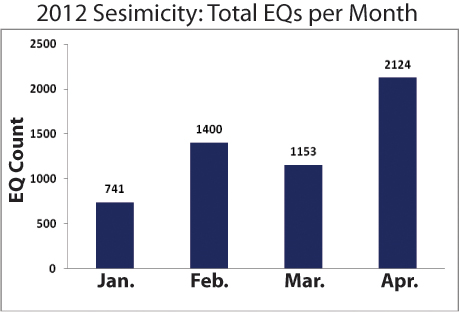 |
Figure 22. Total earthquakes detected from San Cristóbal during January-April 2012. Courtesy of INETER. |
In January, tremor persisted for 1-12 hours per day for a total of 118 hours. In February, tremor duration averaged 4 hours/day (131 hours); in March, 6 hours/day (166 hours); in April, 2 hours/day (38 hours); and in June, 5 hours/day (23.5 hours). No estimates were available for May.
From January through April 2012, a class of seismic events considered "degassing earthquakes" (DE) were detected throughout the seismic records. These events were characterized in spectrograms as events in the range of 4-10 Hz. INETER described the events as resulting from gas moving through the conduit, causing displacements and, after building pressure in confined spaces, the pressure was released impulsively, generating low-amplitude shockwaves and arriving as emergent seismic signals with low energy. These conditions suggested that the volcanic system was partially open (as opposed to a closed system that would be expected to pressurize). Individual DEs occurred with durations of ~60 seconds, and up to 1,379 DE events were recorded in April 2012 with dominant frequencies of 5-10 Hz.
Volcano-tectonic (VT) earthquakes were a minor part of San Cristóbal's seismicity during January-June. Typically occurring 6-15 km deep, the maximum number of VT events occurred in March; 39 earthquakes were detected with dominant frequencies in the range of 10-20 Hz.
Long-period (LP) earthquales dominated the seismic record in June; 1,413 events were recorded (22-707 monthly events were noted in the records during February-April). The duration of these signals ranged from 40-90 seconds with dominant frequencies of 1-5 Hz. Depths of these events were not announced, but in March and April, LPs occurred at depths of 6-25 km.
Reports from INETER during the volcanic crisis in September highlighted sporadic signals indicating eruptions in the seismic records along with tremor and the appearance of shallow, low-magnitude events (microseismicity). Elevated seismicity on 8 September decreased dramatically by 10 September. Seismic tremor increased on 14 September, however, by 16 September, seismicity had returned to normal levels.
SO2 monitoring. In January 2012 INETER reported that three miniature Differential Optical Absorption Spectrometer (Mini-DOAS) stations were installed in the field around the flanks of San Cristóbal. These stations stored SO2 flux data locally and telemetered it to the INETER network through the El Chonco repeater. These installations were part of the Network for Observation of Volcanic and Atmospheric Change (NOVAC), a collaboration supported by the European Union's Natural Disasters Program (Galle and others, 2009).
Employing a mobile DOAS, INETER collected SO2 data on traverses in March; five traverses were made between the junction of Chinandega and Corinto and the town of Las Grecias (for town locations, see BGVN 36:12 figure 20). The average SO2 flux recorded on 30 March 2012 was 542 t/d; the reported wind velocity was 5 m/s to the E. Previous measurements from this region (10 January 2011) yielded an average SO2 flux of 436 t/d.
Thermal data and visits to the summit. INETER technicians noted regular gas emissions from San Crisóbal's summit from January through August 2012. During field investigations to the summit (April-August 2012), loud jetting was heard one day (22 April) coming from the central crater. That day, gas emissions were relatively low and there was evidence of numerous rockfalls from the W side of the crater. Vapor plumes drifted mainly W and E of the crater depending on wind direction.
Fumarole temperatures measured from April through August show small variations in the range of 50-93°C (figure 23). These measurements were taken from five sites located within the SE sector of the crater rim. The previous temperature from the central crater was last measured on 3 December 2011 (382°C); the most recent measurement, on 20 June 2012, was 543.7°C.
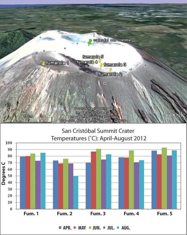 |
Figure 23. (Top) Site locations of fumaroles found along the SE summit rim of San Cristóbal and visited in 2012. The white color is due to heavy steam emissions which have conformed with the topography due to GoogleEarth 3D rendering. (Bottom) Fumarole temperatures (grouped by fumarole) during April-August 2012. INETER noted that lowest temperatures were obtained from Fumarole 2 (50-73°C) while other sites showed variations between 70 and 93°C (the maximum measured from Fumarole 5). Courtesy of INETER. |
Heavy rain in May restricted field operations, however, on 24 May INETER technicians visited the lower flanks of San Cristóbal to maintain seismic and gas instrumentation. They encountered evidence of a lahar that had covered the main trail between the Hacienda Las Rojas and Pedro Marín to the SW of the summit. The lahar had reached a maximum height of 0.8 m and was up to 15 m wide.
Field investigations to the summit on 20 June determined that deep channels had been eroded in the W flank of the volcano, exposing loose soil (figure 24). INETER advised vigilance for this region since the soil could easily remobilize as a mudflow with heavy rainfall. The W flank was particularly at risk due to a forest fire that, in April 2012, removed significant vegetation that would otherwise have provided some stability for the steep slopes. Particularly vulnerable locations would be the areas of Las Rojas and Pedro Marín, farming areas within the drainage network on the W flank.
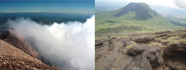 |
Figure 24. Views from the summit of San Cristóbal volcano on 20 June 2012. (Left) A diffuse plume of vapor that reached ~200 m above the summit crater, drifting NE. (Right) With the El Chonco peak in the distance, INETER staff photographed fresh signs of erosion on the W flank of the volcano attributed to recent heavy rainfall. Courtesy of INETER. |
Ash explosions in September 2012. At 0845 local time on 8 September, a substantial ash plume erupted suddenly from San Cristóbal's summit, followed by a second plume 10 minutes later. Later that day, INETER confirmed GOES-13 satellite observations of a wide-spreading ash plume from the summit of San Cristóbal (figure 25). Three explosions produced ash-and-gas plumes that day and were observed rising up to 1.5 km above the crater and drifted 9 km/hr NW (figure 26).
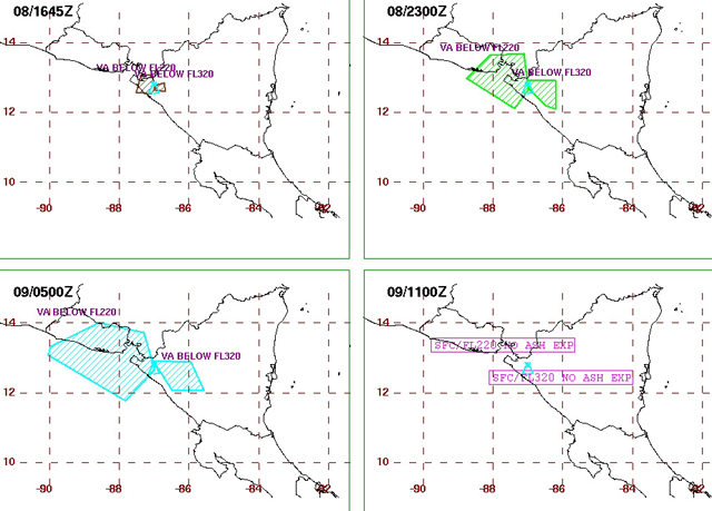 |
Figure 25. Distribution of ash plumes from the 8 September summit explosion of San Cristóbal. The top left image (at 1645 UTC) represents a best fit polygon of the ash plume based on satellite imagery while the other images are the forecasted distributions of the plume for the following 6, 12, and 18 hours. Courtesy of Washington VAAC. |
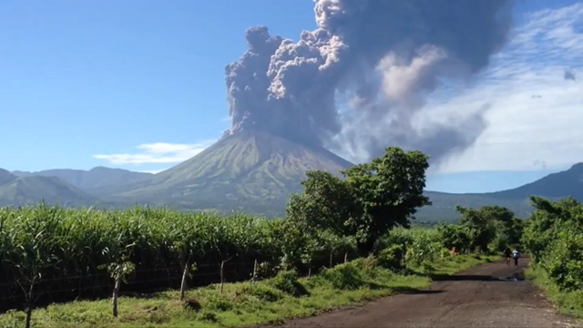 |
Figure 26. A still-shot from a video taken of the dense ash plume from San Cristóbal on 8 September 2012. The location of this recording was not disclosed but the view is directed S with the El Concho peak to the far right-hand side. Time of the video was undisclosed. Courtesy of YouTube contributor A Callejas. |
On 8 September INETER released special online reports announcing observations and volcanic crisis incidents. Residents reported ashfall at El Viejo (18 km WSW of San Cristóbal), El Chonco, and Ranchería. Sporadic explosions later that day generated ash plumes that rose 1.5-5 km and drifted 50 km WNW. The sporadic explosions appeared in the seismic records but microseisms (a category of shallow, small-magnitude earthquakes) dominated the record.
Between 0900 and 1000 local time on 8 September, SO2 flux was 3,221 t/d, well above the normal range of 550-700 t/d. Residents in Versalles Arriba, a zone near the crater, reported seeing a fissure-like feature, however, INETER did not report follow-up site visits for this observation. Rockfalls were observed on the N flank; on the NW flank, ash mixed with incandescent rock fell in an area occupied by livestock. Field investigators noted that six animals were burned from this event.
According to a news article, emergency officials evacuated ~3,000 people by 1857 local time. The national emergency agency of Nicaragua (Sistema de Prevención, Mitigación y Atención de Desastres, SINAPRED) reported that airplanes were diverted around San Cristóbal to other routes.
Rainfall was closely monitored on 8 September. By 1600 local time, 26.1 mm of rain had fallen and INETER warned of possible mudflows resulting from remobilized ash. Thunderstorms were expected on 9 September in the region of Chinandega and INETER warned that acid rain could result from the mixture of volcanic gases.
During 9 September, INETER coordinated field teams that investigated ashfall within the region. These teams determined that ash fell in an area covering 2,438 square kilometers, including the communities of El Viejo, La Grecia, La Joya, Santa Catalina, El Piloto, Las Banderas, Las Rojas, Carlos Fonseca, Jiquilillo, Mechapa, and Cosiguina (figure 27). Ashfall was 5 cm thick in areas near the crater and up to 3 mm thick in more distant places.
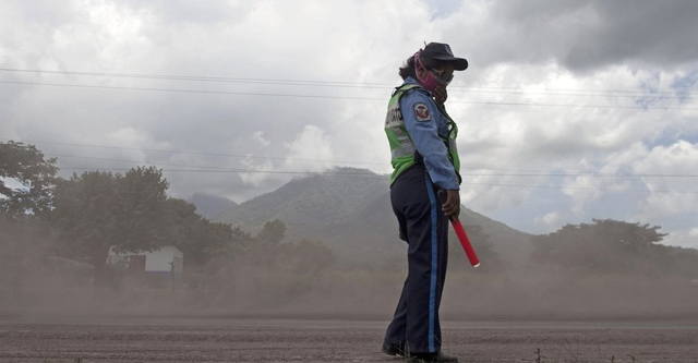 |
Figure 27. Several towns and roads were blanketed with ash from San Cristóbal on 8 September. This Nicaraguan police officer wears a protective mask to prevent inhaling the fine volcanic ash. Courtesy of the Associated Press/Esteban Felix. |
By 10 September, INETER reported that seismicity decreased after the 8 September eruption. A traverse between Chinandega and El Guasaule during 0700-0830 with a mobile DOAS measured an SO2 flux of 1,626 t/d. This emission rate was significantly lower compared to the previous day.
During 10-11 September, steam plumes rose 200-300 m above the crater and drifted W. Three small explosions on 11 September generated ash-and-gas plumes that rose 300 m above the crater and drifted W. An explosion and ash venting was observed a few hours later; a plume drifted S and ash fell on the flanks. Microseismicity continued; at 0900 on 11 September, 63 small events had been recorded so far that day.
Abundant gas emissions were observed on the morning of 12 September. RSAM was notably higher (by 35 to 70 RSAM units compared to the previous day). At the time of the Special Report on 12 September at 1100 local time, 86 microseismic events had been recorded.
On 13 September, INETER reported that the seismic network continued to detect small, sporadic explosions. Sulfur dioxide gas emissions were above normal (1,360 t/d), similar to levels detected on 8 September. RSAM calculated since the release of the last INETER Special Report was considered normal, 40-60 RSAM units, and microseismicity appeared to have decreased (only 17 events had been detected).
Fieldwork was conducted on 13 September as a joint venture between INETER and the El Salvadoran agency Servicio Nacional de Estudios Territoriales de El Salvador (SNET). The scientific team reached the summit crater of San Cristóbal to measure temperatures, collect rock samples, and observe current conditions. They noted that portions of the crater had collapsed (N and S sectors) and found blocks and ejecta on the flanks, 850 m from the crater. Changes had also occurred in the summit fumarolic areas. Three of the five fumarolic sites no longer emitted gas; these sites appeared to be sealed. Fumaroles 1 and 2 had measurably elevated temperatures (85°C), broadly similar to previous values recorded (figure 23). Based on the field assessment of ejecta, INETER warned that mudflows remained a hazard during heavy rainfall.
Increased seismic tremor was recorded at 0340 on 14 September. Low levels of summit emissions were visible drifting in a plume to the SW. Elevated SO2 flux continued (2,490 t/d). The following day, abundant gas emissions were visible drifting NE and SO2 emissions had increased (3,054 t/d). RSAM had increased to 120 on 15 September. A small explosion was detected at 0817 local time; however, there was no visual confirmation due to cloud cover.
Early in the morning on 16 September, minor tremor was recorded and few earthquakes were recorded. The seismic events were too small to be located and INETER reported that, based on RSAM, seismicity had returned to normal levels (40 RSAM units). Low level emissions were visible and less SO2 was detected compared to the previous two days (2,053 t/d). By 17 September, no tremor was recorded and minor emissions were visible drifting N of the crater.
References. A Callejas, 2012, Volcan San Cristobal en erupción - Nicaragua Sept 8, 2012 (from YouTube), Uploaded on 10 September 2012, Accessed on 3 October 2012, http://www.youtube.com/watch?v=hQStun1FF3o&feature=related.
Galle, B. and the NOVAC Team, 2009. NOVAC - A global network for volcanic gas monitoring, 6th Alexander von Humboldt International Conference, Abstract AvH6-34-1, 2010.
Geological Summary. The San Cristóbal volcanic complex, consisting of five principal volcanic edifices, forms the NW end of the Marrabios Range. The symmetrical 1745-m-high youngest cone, named San Cristóbal (also known as El Viejo), is Nicaragua's highest volcano and is capped by a 500 x 600 m wide crater. El Chonco, with several flank lava domes, is located 4 km W of San Cristóbal; it and the eroded Moyotepe volcano, 4 km NE of San Cristóbal, are of Pleistocene age. Volcán Casita, containing an elongated summit crater, lies immediately east of San Cristóbal and was the site of a catastrophic landslide and lahar in 1998. The Plio-Pleistocene La Pelona caldera is located at the eastern end of the complex. Historical eruptions from San Cristóbal, consisting of small-to-moderate explosive activity, have been reported since the 16th century. Some other 16th-century eruptions attributed to Casita volcano are uncertain and may pertain to other Marrabios Range volcanoes.
Information Contacts: Instituto Nicaragüense de Estudios Territoriales (INETER), Apartado Postal 2110, Managua, Nicaragua (URL: http://www.ineter.gob.ni/); Washington Volcanic Ash Advisory Center (VAAC), Satellite Analysis Branch (SAB), NOAA/NESDIS E/SP23, NOAA Science Center Room 401, 5200 Auth Rd, Camp Springs, MD 20746, USA (URL: http://www.ospo.noaa.gov/Products/atmosphere/vaac/); La Prensa de Nicaragua (URL: http://www.laprensa.com.ni/2010/07/04/nacionales/30240); La Prensa de Honduras (URL: http://www.laprensa.hn); BBC: Latin America & Caribbean (URL: http://www.bbc.co.uk/news/world-latin-america-19533933).