Report on Nevado del Ruiz (Colombia) — August 2012

Bulletin of the Global Volcanism Network, vol. 37, no. 8 (August 2012)
Managing Editor: Richard Wunderman.
Edited by Julie A. Herrick.
Nevado del Ruiz (Colombia) Several years of escalating seismicity followed by ash explosions
Please cite this report as:
Global Volcanism Program, 2012. Report on Nevado del Ruiz (Colombia) (Herrick, J.A., and Wunderman, R., eds.). Bulletin of the Global Volcanism Network, 37:8. Smithsonian Institution. https://doi.org/10.5479/si.GVP.BGVN201208-351020
Nevado del Ruiz
Colombia
4.892°N, 75.324°W; summit elev. 5279 m
All times are local (unless otherwise noted)
Our last report on Nevado del Ruiz (BGVN 37:07) summarized monitoring efforts by the Instituto Colombiano de Geología y Minería (INGEOMINAS) volcano observatory based in Manizales, highlighting the long records of geophysical and radon-gas data starting in 1988 and continuing through 2006. Here we follow up on volcanic activity from 2007 to 2012, including an escalation leading to explosions in February 2012. Elevated seismicity, wide-spread ashfall, and very high SO2 fluxes (~30,000 tons/day) resulted in a Level I Red Alert announcement (on a scale from IV to I, Alert Level I is the highest, "Red Alert") in June 2012 and public notices of evacuations. Activity subsided in July 2012 and remained low through the remainder of this reporting period ending 9 September 2012.
Seismicity from 2007-August 2010. From 2007 to August 2010, INGEOMINAS reported numerous volcano-tectonic (VT) and long-period (LP) events originating at depths of 1-12 km below Nevado del Ruiz. Rare hybrid and tremor earthquakes were detected, and seismic swarms occurred intermittently (19-78 events per swarm; figure 54). Seismicity was frequently concentrated within the crater and to the SE, S, SW, and W (table 3).
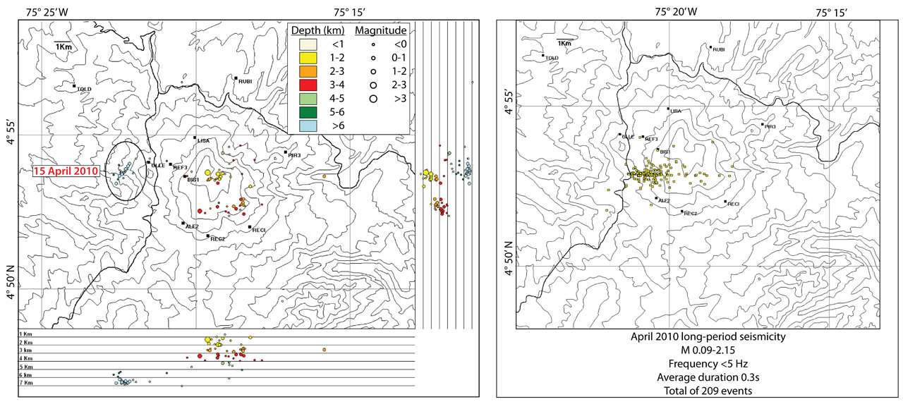 |
Figure 54. Maps of located earthquakes at Nevado del Ruiz during the month of April 2010. (Left) This map shows the distribution of VT events and cross-sections for depths in 1 km intervals; the 15 April 2010 swarm is circled. (Right) This map shows 209 registered LP events (M 0.09-2.15); frequencies were below 5 Hz with average event durations of 0.3 s. LP events were concentrated in a zone to the W of the crater, a characteristic observed in records since 2006. Courtesy of INGEOMINAS. |
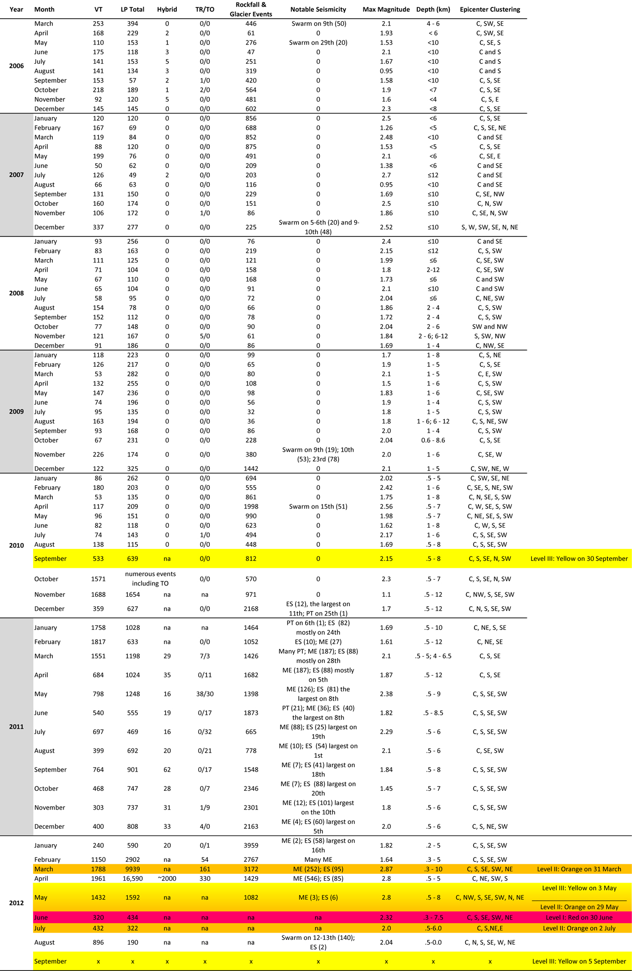 |
Table 3. Seismicity types and counts at Nevado del Ruiz registered from 2006 to September 2012 compiled from INGEOMINAS reports. The LP Total column accounts for all forms of LPs including hybrid and tornillo when present; tornillo earthquakes are described by Narváez and others (1997). The TR/TO column contains tremor ("TR") and tornillos ("TO"). Epicenter Clustering refers to directions relative to the crater, and to epicenters occurring within the immediate crater region "C". Notable Seismicity includes swarms with dates and the number of events provided when known in parentheses; seismicity interpreted as possible explosions is listed as "ES" (explosion signature); multi-events ("ME") refer to seismicity that is described in figure 56; pseudo-tornillo events are listed ("PT"), a class of earthquakes also detected at Galeras volcano (BGVN 37:04) and illustrated in figure 55. For all entries with "na," this represents seismicity that has been recorded but only tallied within the LP Total column. The "x" indicates values not currently available. Shading (yellow, orange, and red) corresponds to the alert announcements released by authorities according to the level of hazardous conditions. Courtesy of INGEOMINAS. |
Geodesy, 2007-August 2010. Deformation monitoring expanded in late 2007 when INGEOMINAS installed additional electronic tilt stations, augmenting their dry tilt datasets. Dry tilt measurements had been recorded since at least 1986 (see the station distribution map, figure 10 in BGVN 37:07). While the term "dry tilt" is pervasive in volcano monitoring literature, this can cause confusion as it was originally adopted to differentiate measurements made with water leveling techniques (Yamashita, 1992). Alternative terms are "single-setup leveling" or "tilt leveling" however, the term "inclinómetro seco," has been used consistently throughout INGEOMINAS monthly technical reports since March 2006. Tilt measurements collected with site occupation techniques are manually intensive, requiring extensive field time, reliable benchmark pairs, a spirit level, and leveling rods. In August 2010, dry tilt values were available from three stations and electronic tilt values were available from five operating stations; results were reported in the INGEOMINAS technical bulletin (available online).
In August 2008, electronic distance meter (EDM) base stations and reflectors were installed on the W flank of the volcano. Site occupations at Olleta and Refugio recorded stable conditions from September 2008 through August 2010.
Gas emissions, 2007-August 2010. Frequent steam plumes were visible reaching 50-850 m above the crater from January 2007 through August 2010. On 17 July 2010, the Washington Volcanic Ash Advisory Center (VAAC) was alerted to a spike in seismicity detected at Nevado del Ruiz. Several aviation alerts were released; however, no volcanic ash was detected in satellite imagery and advisories were canceled that same day. Several peaks in diffuse soil CO2 emissions were detected in mid-2008 from two geochemical stations, Gualí and Cajones (N and S of the summit, respectively).
Radon-gas emissions measured at Gualí and Cajones also showed peaks in early 2010. INGEOMINAS had maintained emission records since 1995 and was investigating links between radon emissions and earthquakes (Garzón and others, 2003). Radon hazard investigations had been conducted in Manizales (located ~30 km NW of the volcano) by INGEOMINAS that determined water supply and household levels of radon (Salazar and others, 2003). This baseline data was mapped for SE Manizales and showed low levels of radon in water supplies and also low levels at the 43 indoor sites where passive sampling detected an average of 1.9 pCi/L.
During fieldwork on 30 November-1 December 2009, INGEOMINAS installed two scanning Differential Optical Absorption Spectrometer (DOAS) systems within 5 km W of the edifice. Stations Bruma and Alfombrales were telemetered to send SO2 flux data to the Manizales observatory where results were analyzed with NOVAC software. The Network for Observation of Volcanic and Atmospheric Change (NOVAC), designed by the European Commission's Sixth Framework Program, supported this installation. Colombia was one of seven countries participating in the program that sought to monitor and assess SO2 emissions from active volcanoes (Galle and others, 2009). During 2-29 December, SO2 flux ranged 195-554 t/d at Bruma and 41-140 t/d at Alfombrales.
Escalating seismicity from September 2010 to 2011. Seismicity notably increased in September 2010 and prompted authorities to raise the alert to Level III (Yellow, on the four-level scale) on 30 September (table 3). Within four months, pseudo-tornillo earthquakes (figure 55) and possible explosive signatures appeared in the seismic record. From September 2010 through December 2011, an average of more than 890 VT earthquakes per month were recorded, almost eight times as many events as recorded during the previous 12 months. A similar increase in LP events was also observed during this time period; however, epicenters were clustered in the same regions as previous years: within the crater, to the SE, S, SW, and W (as in figure 54).
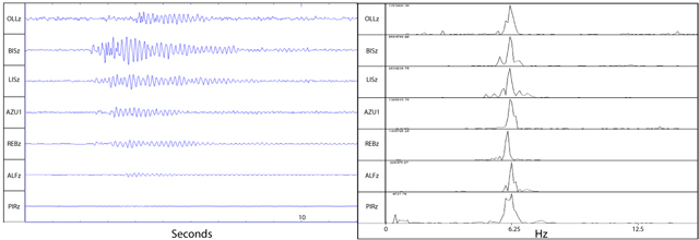 |
Figure 55. This long-period earthquake (described as a pseudo-tornillo) was recorded on 6 January 2011 at 1343 from Nevado del Ruiz on seven seismic stations (appearing strongest on station BISz, the trace second from the top). BISz is the closest seismic station to the volcano, located ~2 km W of the crater. The spectra (right) show a dominant frequency of ~6.25 Hz; this characteristic, in addition to the relatively short coda, classified the event as a pseudo-tornillo (Narváez and others, 1997). Courtesy of INGEOMINAS. |
A type of earthquake classified as "multi-event" began to appear in February 2011 (see ME events in table 3). These events frequently occurred from February through August and were attributed to small explosions and degassing (figure 56). Tremor and tornillo earthquakes were recorded in March of 2011 and, over the next six months, occurred more frequently with time.
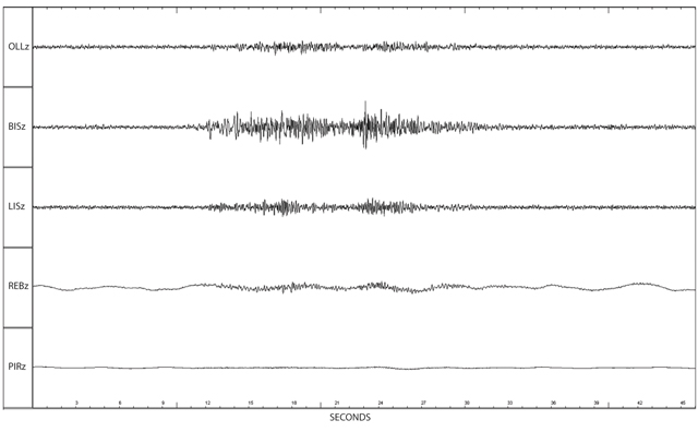 |
Figure 56. Seismic traces of a "multi-event" registered at 1351 on 6 October 2011 as recorded at five stations around Nevado del Ruiz. The earthquake appeared strongest at BISz, the closest station to the volcano, and much weaker-to-unrecognizable at other stations. Courtesy of INGEOMINAS. |
Geodesy, September 2010-2011. During September 2010-2011, INGEOMINAS recorded stable conditions with minor fluctuations from the EDM stations Refugio and Olleta. Both stations were surveyed in February, October, and November 2011, and only Refugio was surveyed in September and December.
INGEOMINAS noted an increasing trend at the electronic tilt station LISA that began in October 2010 and continued through 2011; the two components registered a cumulative increase of 20 µrad. RECIO had been recording stable conditions until May 2011; from May through December 2011, the N component increased by 23 µrad and the E component decreased by 10 µrad. Corrective measures had been taken to protect the BIS and REFUGIO tilt stations from thermal effects, however, cyclical changes persisted in their datasets. By December 2011, seven electronic tilt stations were online and were recording minor fluctuations primarily due to temperature change.
Permanent GPS stations Gualí and Nereidas were installed on the lower W flanks between May and August 2011 and a third station, Olletas, was online by November 2011. GPS instrumentation and continuous data processing were part of a collaborative effort between INGEOMINAS and the University of Wisconsin, Madison.
SO2 emissions, 2010-2012. Since installation of the two scanning DOAS stations in late 2009, background levels of SO2 were rarely higher than 1,000 t/d until September 2010. INGEOMINAS recorded increased SO2 emissions in late 2010 (figure 57), while plumes rose to heights of 220-1,000 m above the crater (averaging ~700 m) through 2011. An increase was observed from November 2010 through much of 2011; maximum daily values of SO2 flux frequently exceeded 1,500 t/d. Occasional peaks above 3,000 t/d were recorded from November 2010 to January 2011 (a), June-July 2011 (b), and November 2011 to February 2012 (c). Beginning in February 2012, emissions dramatically increased during a period of escalated seismicity (table 3). SO2 flux peaked during May and June; the three strongest peaks were greater than 33,000 t/d. By late June, emissions were declining.
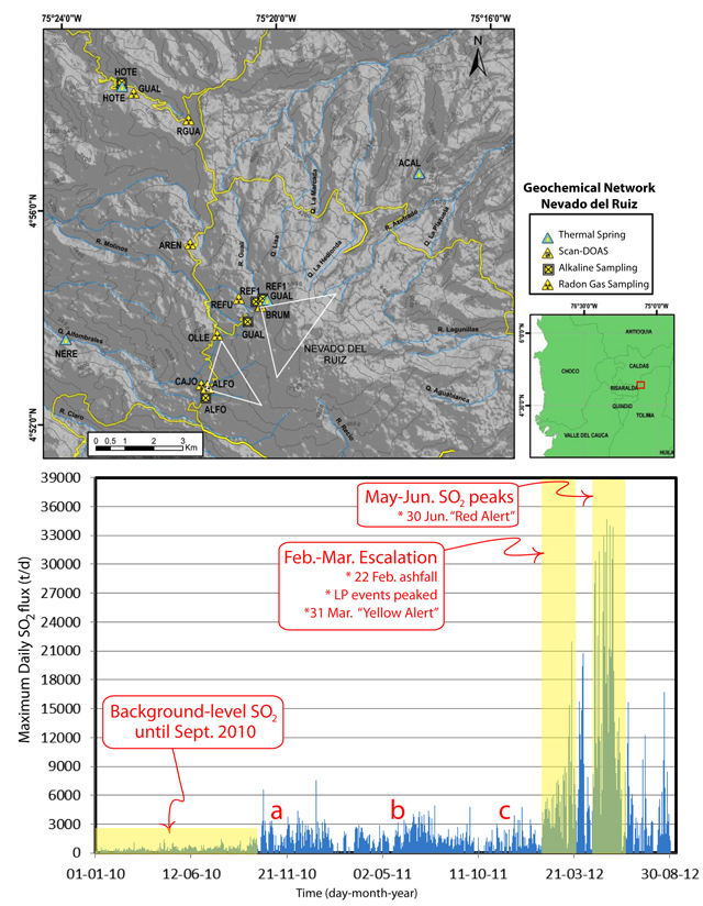 |
Figure 57. (Top) The map of the geochemical network for Nevado del Ruiz shows sites for thermal springs, scanning Differential Optical Absorption Spectrometer (DOAS) stations (white triangles show coverage area directed toward the crater), alkaline sampling, and radon gas sampling. (Bottom) The histogram summarizes maximum daily SO2 flux from scanning DOAS stations from January 2010 through August 2012. Following a period of low emissions during January-September 2010 (highlighted in yellow), three periods of increased SO2 flux occurred (a, b, c) and significant escalation was observed during February-March 2012 and May-June 2012 (vertical yellow bars). Annotated areas are approximations of time periods. Courtesy of INGEOMINAS. |
Explosive activity in 2012. In late January 2012, while SO2 flux began to increase dramatically (figure 57), explosion signatures (also described as strong degassing events) and multi-events continued to appear in the seismic records. On 8 March an overflight of the summit provided INGEOMINAS scientists a view of ash-covered snow on the E flank and near the crater rim (figure 58); in their monthly report, INGEOMINAS suggested this ash may have fallen during an explosion detected on 22 February 2012.
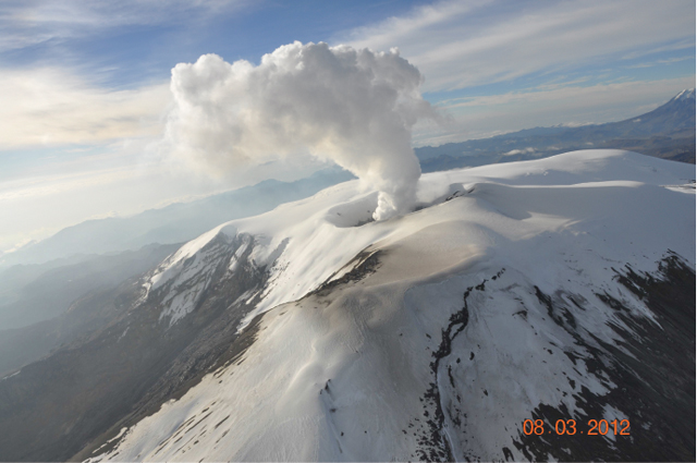 |
Figure 58. This photo was taken during a flight past Nevado del Ruiz's active crater at 0705 on 8 March 2012. Viewed from the Azufrado sector (NE of the summit crater), a column of gas was rising to a maximum height of ~1,400 m above the crater. A thin layer of ash was visible on the snow near the crater (in the foreground of the image). Courtesy of INGEOMINAS. |
On 29 March authorities raised the alert to Level II (Orange) when LP seismicity underwent a ~100-fold increase and banded tremor persisted (table 3).
Based in part on information captured by webcameras around the volcano (including one in Manizales located 30 km NW of Nevado del Ruiz), INGEOMINAS reported that plume heights had increased significantly in March 2012 (figure 59). Reports from local populations around the volcano also alerted INGEOMINAS of sulfur odors. Residents smelled these odors during March; April, May, and August reports were from Manizales, Lebanon, Palocabildo, and Chinchiná.
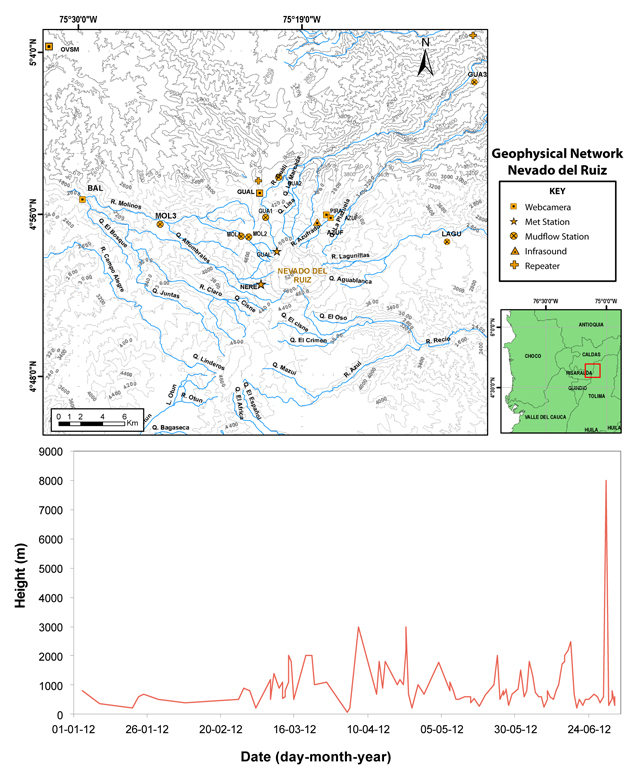 |
Figure 59. (Top) The map of Nevado del Ruiz's geophysical monitoring network includes webcameras, meteorological stations, mudflow stations with acoustic flow sensors, and infrasound. (Bottom) Plot of plume height above the crater as measured from webcameras located near the flanks (including sites Piraña (PIRA), Gualí (GUAL), and Manizales (OVSM)) from January through June 2012. Courtesy of INGEOMINAS. |
The national park surrounding the volcano, Los Nevados National Park, closed in April 2012 due to possible ashfall and lahar hazards. The rainy season (March-June) had begun and mass wasting on the steep slopes, especially of remobilized ash, was a major concern. "Most lahars are initiated as dilute, subcritical flows high on volcanic slopes, but quickly increase their volumes as they incorporate sediment along travel paths (Lockwood and Hazlett, 2010)."
On 16 and 19 April 2012, INGEOMINAS observed ash emissions from the summit and on 22 April, Washington VAAC announced possible ash in the steam plume. Volcanic ash was detected later with satellite imagery, spreading ~110 km NE of the summit on 29 May.
Seismicity decreased in early May 2012 to levels observed before the escalation began in February, and fewer explosions and multi-events were recorded. On 3 May authorities lowered the alert to Level III (Yellow). Conditions at Nevado del Ruiz continued to change, however, and when seismicity abruptly increased, the Alert Level was raised to Level II (Orange) on 29 May (table 3, figure 60). That day, explosions from the crater generated ash plumes that dispersed over more than 20 communities located to the WNW, NW, and NNW. Washington VAAC released four notices on 29 May describing ash up to 11 km altitude. News media reported that three primary airports in the region (Manizales, Pereira, and Armenian) collectively canceled ~20 flights that affected ~700 passengers on 29 May.
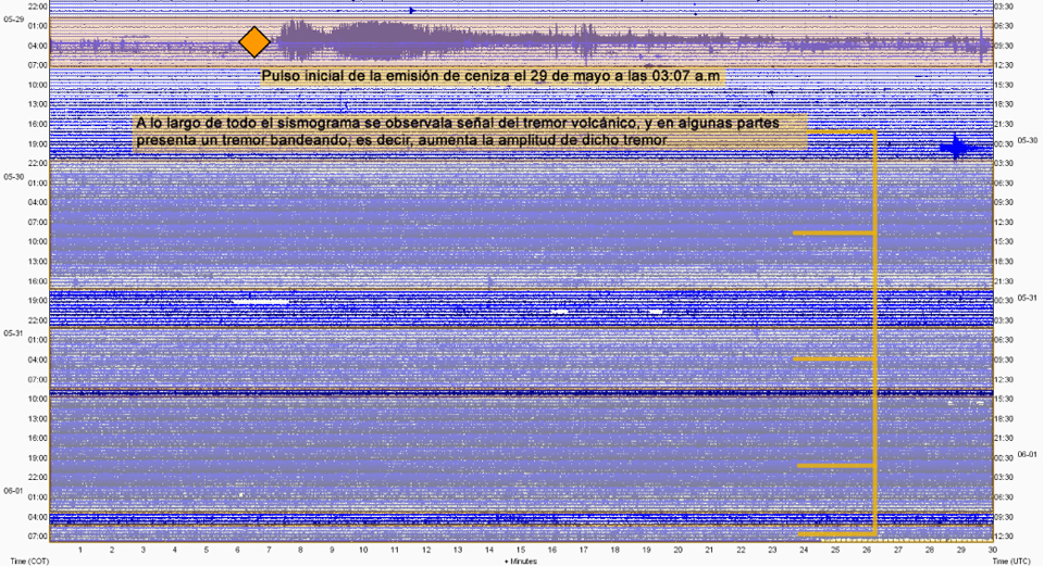 |
Figure 60. A seismic record from Nevado del Ruiz starting just prior to 29 May 2012 and ending slightly past noon on 1 June 2012. The notes explain the start of ash emissions (top shaded bar), alert announcement (orange diamond), and intervals of tremor (shaded bars with orange connected lines). Translation of text: Initial pulse of ash emission at 0397 on 29 May. Throughout the seismogram, volcanic tremor is present and in parts, appears as banded tremor that increases in amplitude. Courtesy of INGEOMINAS. |
Widespread ashfall in early June 2012 required field maintenance by INGEOMINAS to clear ash from solar panels and equipment (figure 61). Imagery captured by the NASA satellite EO-1 revealed a two-toned summit disclosing partial ash cover over the white summit glacier (figure 62). The seismic station INDERENA, acoustic flow station MOLINOS, and the radio repeater that served Nevado del Ruiz, Tolima, and Santa Izabel volcanoes were disabled due to ash cover. Washington VAAC released advisories regularly until 24 June; ash reached altitudes in the range of ~5.5-7.6 km. Plumes tended to drift N, NW, WNW, and W; however, an ash plume on 8 June drifted ~28 km SE. The range of plume lengths was 28-110 km until a period of quiescence during 25 June-2 July.
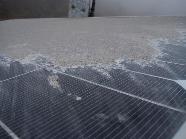 |
Figure 61. Ash covered several solar panels as well as field equipment located near Nevado del Ruiz's W flank in June 2012. Here, at near-equatorial latitude (~5° N), the panels are typically oriented near-horizontal for effective solar exposure which also makes it easy for ash to collect and not wash away. Courtesy of INGEOMINAS. |
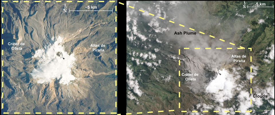 |
Figure 62. (Left) This image was taken by the NASA Expedition 23 crew on 23 April 2010, with a Nikon D3S digital camera fitted with an 800 mm lens. A steam plume drifts SW from the summit crater, blending in with the snow-cover. The summit crater is indicated with a black arrow and the neighboring features, Cráter de Olleta and Altas de Piraña correspond with the outlined field of view in yellow in the left image. Note the scale is approximate and there is some skew to this image as it was taken from a shuttle flight as opposed to the orbiting satellite. Courtesy of NASA. (Right) This satellite image of Nevado del Ruiz was taken during significant ash explosions on 6 June 2012. The summit glacier displays the sharp contrast of muted gray on the NW due to ash cover and bright white on the SE where ash had not fallen. The black arrow points to the summit crater and white clouds are concentrated in the NW and SE corners of the image that also partially cover the peak Altas de Piraña. Image courtesy of NASA by Jesse Allen and Robert Simmon using EO-1 Advanced Land Imager data. |
On 30 June 2012, seismicity increased and large plumes of ash vented from the summit (figure 63). At 1700 that day, authorities raised the alert to Level I (Red). Local news media reported the preventative evacuation notice provided by the Emergency Committee of Caldas; Caldas is the department of Colombia encompassing Nevado del Ruiz and six districts, 27 municipalities, and the capital, Manizales. An estimated 300 families were ordered to evacuate from the rural zones of districts Chinchiná (30 km WNW), Villamaría (28 km NW), Palestina (40 km WNW), and Manizales (30 km NW) due to both escalated explosions and also the potential for flooding along the rivers Chinchiná and Río Claro. In the Department of Tolima, located S of Caldas there was a recommendation to evacuate 1,500 families in risk zones in eight municipalities.
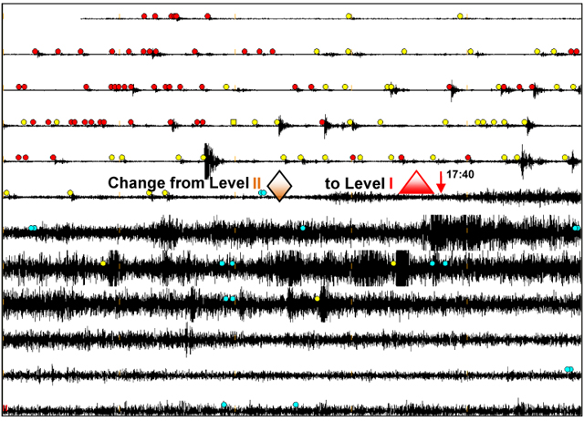 |
Figure 63. A snapshot of the seismic record from Nevado del Ruiz on 30 June 2012 and annotated to mark when officials announced the maximum Alert Level (Level I). Colored circles indicate events associated with fracturing (red), gas and fluid movement (yellow), and tremor resulting from gas or ash emissions (blue). Note that time stamps are not included except for the 1740 arrow. Courtesy of INGEOMINAS. |
On 2 July 2012, Washington VAAC announced a 7.5-km-wide plume visible in satellite imagery that had drifted ~75 km W. Seismicity was decreasing, however, and that same day, authorities lowered the Alert Level to II (Orange). Airborne ash remained visible in satellite images until 8 July and continued to be observed at low elevations based on webcamera images. Ashfall was reported in Pereira (40 km WSW) on 11 July, and on 31 July a plume of ash and gas was observed rising 300 m above the crater.
Low levels of tremor had been detected in late July and throughout much of August 2012. Seismic swarms were detected on 12 and 13 August (table 3) with ~140 low-magnitude events under 5 km deep concentrated WSW of the Arenas Crater. On 6 August, ashfall was reported in Manizales and Chinchiná; on 12 August there were reports of ash in Manizales and Brisas (50 km SW). Through the end of August, plumes (ranging 200-800 m above the crater) were visible from the summit. Field measurements by INGEOMINAS and remote sensing with OMI determined that SO2 emissions remained high (figure 64) through August and early September. On 5 September 2012 authorities reduced the Alert Level to III (Yellow).
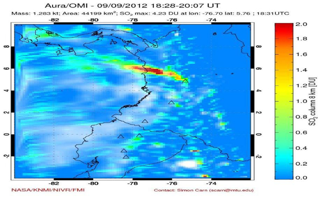 |
Figure 64. A Nevado del Ruiz SO2 plume was detected by the Ozone Monitoring Instrument (OMI) on NASA's AURA satellite on 9 September 2012 from 1328-1507 (local time), extending well over the Pacific Ocean. The mass of SO2 was 1.28 kt, covering an area of 44,199 km2, and the maximum was 4.23 Dobson Units (DU) at 1331 local time. Courtesy of Simon Carn, Michigan Technological University and Joint Center for Earth Systems Technology, University of Maryland Baltimore County. |
Recalling 1985 and additional hazard mitigation efforts. Nevado del Ruiz's most deadly natural disaster was a lahar that, on 13 November 1985, scoured the Lagunillas River (E flank drainage system) and suddenly flooded the towns of Armero, Chinchiná, Mariquita, and Honda (figure 65). Armero was completely destroyed and more than 23,000 residents died. Light ashfall had been reported that day and a seismic network was in place, but no early warning system had been established to initiate evacuations (Lockwood and Hazlett, 2010).
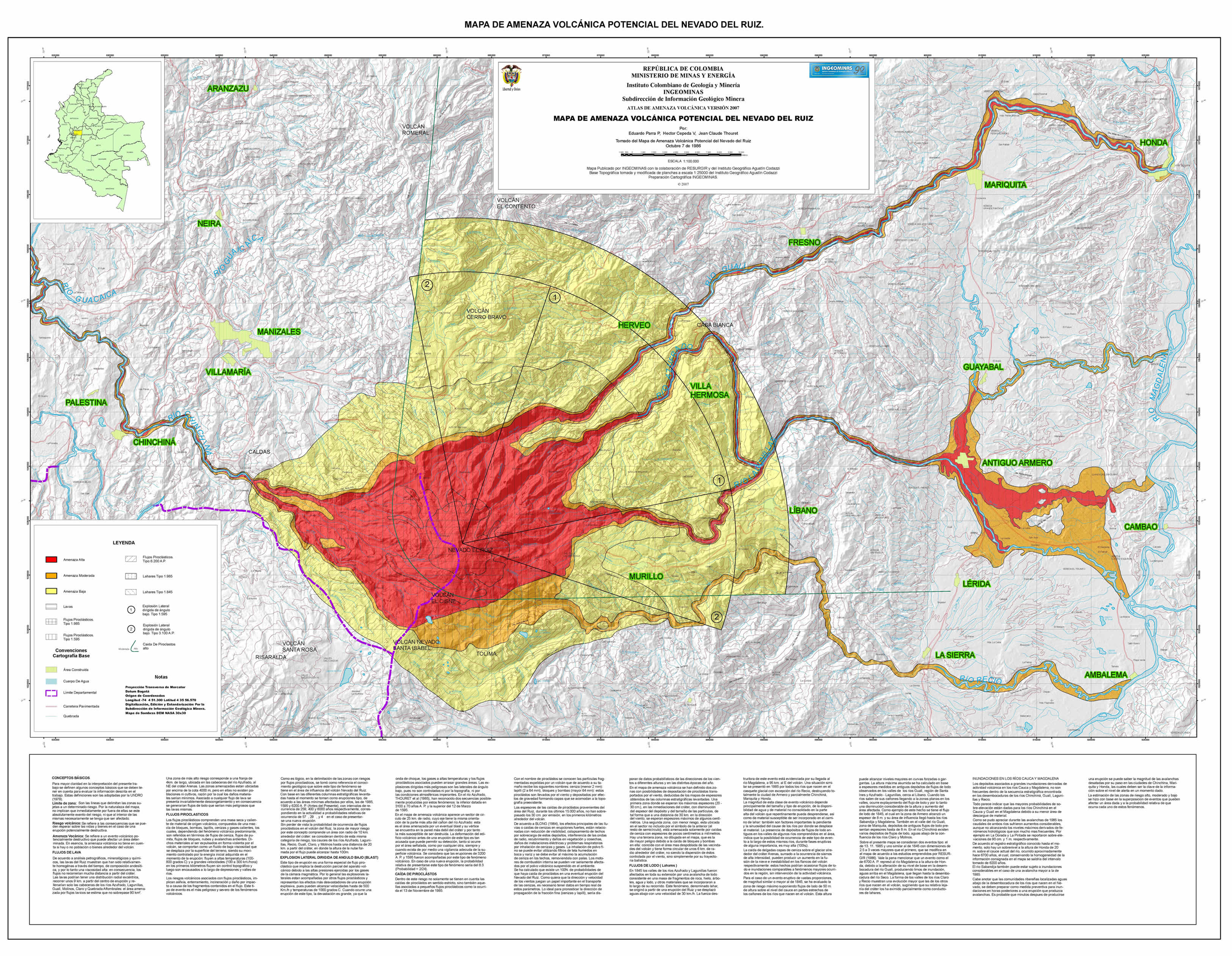 |
Figure 65. Released in 2007, this hazard map of Nevado del Ruiz is dominated by lahar and pyroclastic flow scenarios. Highest risk areas are shaded red with lower risk areas in yellow; note that the town of Armero (Antiguo Armero, 48 km E of the summit) is in a region of high risk. A topographic assessment augmented with substantial field evidence determined flow paths and inundation probabilities within the major drainages of Gualí, Azufrado, Lagunillas, Recio, and Chinchiná (listed clockwise starting with the NE drainage). Pyroclastic flow, ashfall, and lava inundation were also considered and the radial sectors directed NE attribute hazards to lateral explosions based on crater morphology and geologic mapping of tephra units. Names highlighted in green indicate major towns. Courtesy of INGEOMINAS. |
Since 1985, realtime geophysical monitoring greatly increased, including acoustic flow sensors designed to detect impulsive flooding in local drainages. Other advances included mobile gas monitoring (mini-DOAS) that augmented routine geochemical sampling at Nevado del Ruiz and recent hazard map revisions that emphasized inundation scenarios with zoning that clearly communicates areas at highest risk (figure 65). International collaborations with universities and agencies (for example, the University of Wisconsin and the European Union mentioned previously) have focused on mitigation efforts through training and technical resources.
Following the disastrous 1985 lahars, the USGS and the U.S. Office of Foreign Disaster Assistance (OFDA) developed the Volcano Disaster Assistance Program (VDAP) to respond to selected volcanic crises around the world (Ewert and others, 1997). The VDAP mission is to work with international counterparts to reduce fatalities and economic losses in those countries experiencing a volcano emergency. The VDAP website states that "Between crises, VDAP scientists focus on building and improving volcano monitoring systems and conduct joint activities to reduce volcanic risk by improving understanding of volcanic hazards [figure 66]."
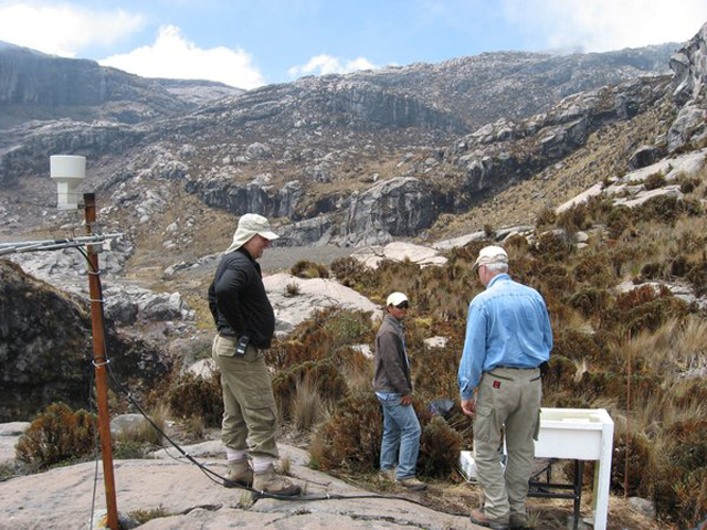 |
Figure 66. The USGS/OFDA Volcano Disaster Assistance Program sent a team of scientists to aid INGEOMINAS and local authorities mitigating risk at Nevado del Ruiz on 28 May 2012. Courtesy of The Columbian. |
References. Ewert, J.W., Miller, C.D., Hendley, J.W., and Stauffer, P.H., 1997. Mobile Response Team Saves Lives in Volcano Crises, USGS Fact Sheet: 064-97.
Galle, B. and the NOVAC Team, 2009. NOVAC - A global network for volcanic gas monitoring, 6th Alexander von Humboldt International Conference, Abstract AvH6-34-1, 2010.
Garzón, G., Serna, D., Diago, J., and Morán, C., 2003. Radon soil increases before volcano-tectonic earthquakes in Colombia, Proceedings of ICGG7: 6-7.
Lockwood, J.P., and Hazlett, R.W., 2010. Volcanoes: Global Perspectives, Wiley-Blackwell, Hoboken, NJ, ix, p.539.
Narváez, L.M., Torres, R.A., Gómez, D.M., Cortez, G.P., Cepeda, H.V., and Stix, J., 1997. 'Tornillo'-type seismic signals at Galeras volcano, Colombia, 1992-1993, Journal of Volcanology and Geothermal Research, 77: 159-171.
Salazar, S., Carvajal, C., and Garzón, G., 2003. Radiological geohazard survey in the south east of Manizales city (Colombia), Proceedings of ICGG7: 3-5.
Yamashita, K.M., 1992. Single-Setup Leveling Used to Monitor Vertical Displacement (Tilt) on Cascades Volcanoes, in Ewert, J. and Swanson, D. (Eds.), Monitoring volcanoes; techniques and strategies used by the staff of the Cascades Volcano Observatory, 1980-90, U.S. Geological Survey Bulletin 1966, pp. 143-149.
Geological Summary. Nevado del Ruiz is a broad, glacier-covered volcano in central Colombia that covers more than 200 km2. Three major edifices, composed of andesitic and dacitic lavas and andesitic pyroclastics, have been constructed since the beginning of the Pleistocene. The modern cone consists of a broad cluster of lava domes built within the caldera of an older edifice. The 1-km-wide, 240-m-deep Arenas crater occupies the summit. The prominent La Olleta pyroclastic cone located on the SW flank may also have been active in historical time. Steep headwalls of massive landslides cut the flanks. Melting of its summit icecap during historical eruptions, which date back to the 16th century, has resulted in devastating lahars, including one in 1985 that was South America's deadliest eruption.
Information Contacts: Instituto Colombiano de Geologia y Mineria (INGEOMINAS), Volcanological and Seismological Observatory, Avenida 12 Octubre 15-47, Manizales, Colombia (URL: https://www2.sgc.gov.co/volcanes/index.html); Washington Volcanic Ash Advisory Center (VAAC), Satellite Analysis Branch (SAB), NOAA/NESDIS E/SP23, NOAA Science Center Room 401, 5200 Auth Rd, Camp Springs, MD 20746, USA (URL: http://www.ospo.noaa.gov/Products/atmosphere/vaac/); Ozone Monitoring Instrument (OMI), Sulfur Dioxide Group, Joint Center for Earth Systems Technology, University of Maryland Baltimore County (UMBC), 1000 Hilltop Circle, Baltimore, MD 21250, USA (URL: https://so2.gsfc.nasa.gov/); El Colombiano (URL: http://www.elcolombiano.com/); The Columbian (URL: http://www.columbian.com/).