Report on Miyakejima (Japan) — November 2012
Bulletin of the Global Volcanism Network, vol. 37, no. 11 (November 2012)
Managing Editor: Richard Wunderman.
Miyakejima (Japan) Minor plumes and low seismicity during April 2010-June 2012
Please cite this report as:
Global Volcanism Program, 2012. Report on Miyakejima (Japan) (Wunderman, R., ed.). Bulletin of the Global Volcanism Network, 37:11. Smithsonian Institution. https://doi.org/10.5479/si.GVP.BGVN201211-284040
Miyakejima
Japan
34.094°N, 139.526°E; summit elev. 775 m
All times are local (unless otherwise noted)
During April 2010-June 2012 the Japan Meteorological Agency (JMA) maintained the hazard status for Miyake-jima at Alert Level 2, where it had stood since 31 March 2008. Our last report (BGVN 34:06) mentioned a minor eruption at Miyake-jima on 1 April 2009 which produced an ash plume that rose ~600 m above the crater. Since that time, activity was relatively low with up to four minor eruptions occurring during April-July 2010, as reported by the Tokyo Volcanic Ash Advisory Center (VAAC) based on information from JMA.
Eruptions occurred on 11 April, 4 July (two possible eruptions during the early morning), and 21 July 2010; the 21 July eruption was the only eruption for which the Tokyo VAAC issued an altitude and drift direction for the plume (~1.2 km altitude with E drift; table 5). The eruptions were characterized by gas and steam emissions lacking significant ash content (e.g. figure 23).
Table 5. Summary of detailed activity reports for Miyakejima during April 2010-June 2012; '--' indicates data not reported. Courtesy of JMA and Tokyo VAAC.
| Month | Gas-and-steam plume heights (m above crater rim) | SO2 flux (metric tons/day) | Remarks |
| Apr 2010 | -- | -- | 11 Apr: Based on information from JMA, Tokyo VAAC reported an eruption at 0840. |
| Jul 2010 | -- | -- | 4 Jul: Based on information from JMA, Tokyo VAAC reported possible eruptions at 1019 and 1434. |
| Jul 2010 | 400 | -- | 21 Jul: Based on information from JMA, Tokyo VAAC reported an eruption at 0928 that produced a plume which rose to an altitude of ~1.2 km (400 m above the crater) and drifted E. |
| Oct 2010 | 100-400 | 500-1,600 | -- |
| Nov 2010 | 100-400 | 500-1,600 | Short duration tremor on 11 and 25 November not accompanied by air-shocks or plume changes. |
| Dec 2010 | 100-400 | 500-900 | -- |
| Jan 2011 | 100-600 | 800-1,000 | -- |
| Feb 2011 | 100-400 | 1,000 | -- |
| Mar 2011 | 100-500 | 600-1,100 | GPS showed continuous deflation from a shallow source. |
| Apr 2011 | 100-500 | 700 | -- |
| May 2011 | 100-400 | 600-900 | -- |
| Jun 2011 | 100-300 | 600 | Low seismicity except for 6 June. Hypocenters located just beneath summit crater. No tremor observed. |
| Jul 2011 | 200-400 | 500 | Low seismicity centered just beneath summit crater. No tremor observed. |
| Aug 2011 | 200-500 | 800-1,000 | Low seismicity with small amplitude, short-duration tremor (~80-90 sec); two increases observed on 18 and 27 Aug. Hypocenters located just beneath summit crater. |
| Sep 2011 | 100-600 | 900 | Low seismicity centered just beneath summit crater. Banded tremor every 20 min. began 23 Sep and continued with smaller amplitudes into Oct. |
| Oct 2011 | 100-400 | 700-900 | Low seismicity centered just beneath summit crater. Continuing banded tremor from Sep ceased on 28 Oct. |
| Nov 2011 | 100-300 | 500-800 | Low seismicity centered just beneath summit crater. Volcanic tremor with small amplitude and short duration (~60 sec) occurred on 12 Nov at 0252; however, no infrasonic signal or ashfall was observed. |
| Dec 2011 | 100-300 | 1,100 | Low seismicity centered just beneath summit crater. No tremor was observed. |
| Jan 2012 | 100-400 | 900-1,200 | Low seismicity centered just beneath summit crater. Five episodes of volcanic tremor with small amplitude and short duration (~40-100 sec) occurred on 18, 22 and 30 Jan. |
| Feb 2012 | 100-400 | 900 | Low seismicity centered just beneath summit crater. |
| Mar 2012 | 100-300 | 600-900 | Aerial observations on 7 Mar revealed high temperature areas located on summit crater's S wall as previously seen in Jan 2010. Low seismicity centered just beneath summit crater; no tremor observed. |
| Apr 2012 | 100-300 | 500-700 | Low seismicity centered just beneath summit crater; no tremor observed. |
| May 2012 | 100-300 | 400 | Low seismicity centered just beneath summit crater; no tremor observed. |
| Jun 2012 | 100-200 | -- | A relatively large A-type earthquake with its hypocenter located around the crater occurred at 0940 on 28 Jun. A seismic intensity of 1 was detected at Miyakejima-Kamitsuki. No tremor observed. |
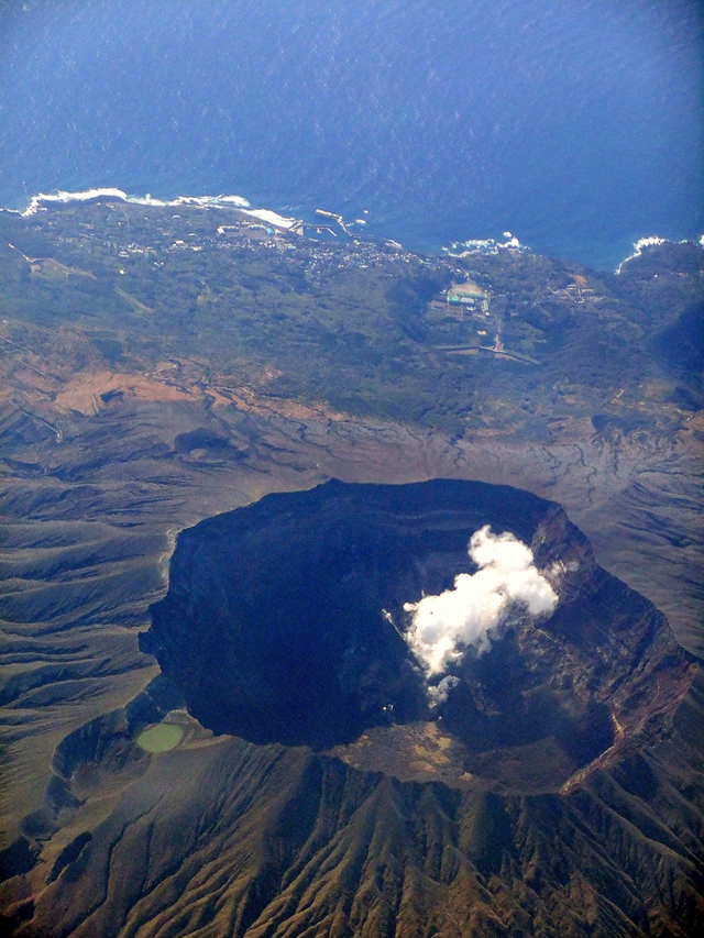 |
Figure 23. A S-looking photograph of Miyake-jima's crater taken from a flight on 17 March 2011 showing an apparent small gas-and-steam emission. Miyake Jima Airport is located along the coast, just out of view to the E. Courtesy of Flickr user R. Forrest. |
JMA reported low levels of seismicity centered just beneath the crater during the reporting interval. Occasional episodes of volcanic tremor occurred, but were not correlated with other data indicating emissions or eruptions (table 5). Sources in Miyakemura village reported that high SO2 concentrations were occasionally detected in some inhabited flank areas.
GPS data revealed contraction in some parts of the edifice, a process that, although diminishing, had continued since 2000. Over the same time period, long-term extension of the baseline along the N-S section of Miyake-jima had been observed since 2006, indicating inflation in deeper portions of the volcano.
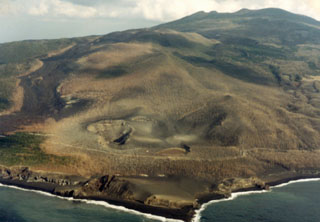
Geological Summary. The circular, 8-km-wide island of Miyakejima forms a low-angle stratovolcano that rises about 1,100 m from the sea floor in the northern Izu Islands about 200 km SSW of Tokyo. The basaltic volcano is truncated by small summit calderas, one of which, 3.5 km wide, was formed during a major eruption about 2,500 years ago. Numerous craters and vents, including maars near the coast and radially oriented fissure vents, are present on the flanks. Frequent eruptions have been recorded since 1085 CE at vents ranging from the summit to below sea level, causing much damage on this small populated island. After a three-century-long hiatus ending in 1469 CE, activity has been dominated by flank fissure eruptions sometimes accompanied by minor summit eruptions. A 1.6-km-wide summit crater was slowly formed by subsidence during an eruption in 2000.
Information Contacts: Japan Meteorological Agency (JMA), Otemachi, 1-3-4, Chiyoda-ku Tokyo 100-8122, Japan (URL: http://www.jma.go.jp/); Tokyo Volcanic Ash Advisory Center (VAAC), Tokyo, Japan (URL: http://ds.data.jma.go.jp/svd/vaac/data/).