Report on Kusatsu-Shiranesan (Japan) — February 2013
Bulletin of the Global Volcanism Network, vol. 38, no. 2 (February 2013)
Managing Editor: Richard Wunderman.
Kusatsu-Shiranesan (Japan) Minor tremor and small earthquakes during 2011-2012
Please cite this report as:
Global Volcanism Program, 2013. Report on Kusatsu-Shiranesan (Japan) (Wunderman, R., ed.). Bulletin of the Global Volcanism Network, 38:2. Smithsonian Institution. https://doi.org/10.5479/si.GVP.BGVN201302-283120
Kusatsu-Shiranesan
Japan
36.618°N, 138.528°E; summit elev. 2165 m
All times are local (unless otherwise noted)
On 7 February 1996, hydrophone data and water level changes suggested that a small hydrothermal ejection may have occurred at Kusatsu-Shirane (also known as Kusatsu-Shiranesan) at Yugama crater's pond (BGVN 21:02). Several months later, on 8 July, numerous small earthquakes were detected by the Kusatsu-Shirane Volcano Observatory (BGVN 21:07). The volcano is about 150 km NW of Tokyo (figures 6 and 7; also refer to the sketch map in figure 1, SEAN 07:10). This report summarizes seismicity between May 2011 and February 2013 based on available reports from the Japan Meteorological Agency (JMA).
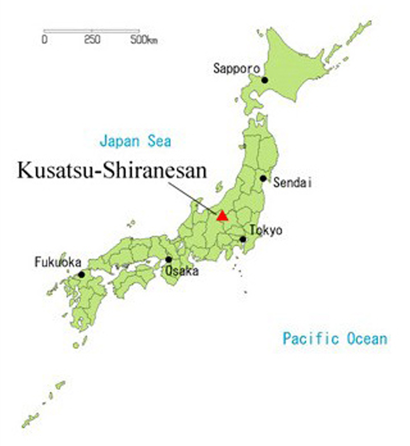 |
Figure 6. A sketch map showing the location of Kusatsu-Shirane (Kusatsu-Shiranesan) in Honsho, Japan. Courtesy of JMA. |
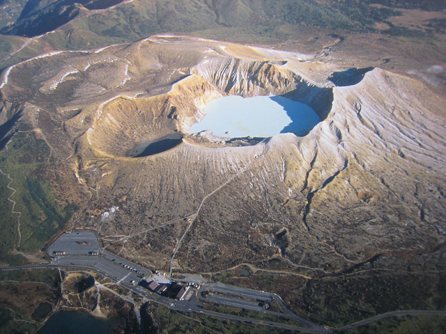 |
Figure 7. An aerial photo of Kusatsu-Shirane, as viewed from the S. The photo, taken on 29 May 2008, shows the overlapping pyroclastic cones and two of the three crater lakes. Courtesy of Flickr user rangaku1976. |
On 27 May 2011, tremor was detected at Kusatsu-Shirane; no further information was provided. During 5-7 June 2011, an elevated number of microearthquakes with low amplitude occurred around Yugama crater (the main crater). No volcanic tremor or significant deformation was detected during this time. Thereafter, activity gradually diminished to background levels.
Field surveys during 27-29 June and 12-13 July 2011 revealed that elevated thermal anomalies persisted inside Yugama crater's N flank, the N fumarole area, and the slope located N to NE of Mizunuma crater. Ground temperatures around fumaroles remained high.
On 18 July 2011, a short period of tremor (duration 2.5 min) was detected. No change in fumarole activity was observed.
On 10 August 2011, an aerial survey was conducted in cooperation with Gunma prefecture. The survey found that the distribution of thermal anomalies and fumaroles in Yugama crater and the N fumarole area had not changed.
During 16-18 August, an elevated number of microearthquakes with low amplitude occurred near and to the S of Yugama crater. Significant deformation was not detected. Seismicity remained at background levels during the other days in August. High temperatures persisted on the N flank inside the main crater.
A field survey on 8 March 2012 found that the high temperatures on the N slope of Mizugama crater and the N fumarole area were the same as those found during a previous survey conducted during 27-29 June 2011. Very weak steam plumes at the N fumarole area of Yugama were sometimes observed by a camera at Okuyamada, though bad weather and mechanical trouble prevented their observation for long periods. The ground temperature in the fumarole area NE of Yugama crater remained elevated since its rapid rise in May 2009, despite occasional fluctuations.
According to JMA, the occurrence of small amplitude volcanic earthquakes occasionally increased during March 2012. The hypocenters were located just beneath the S part of Yugama crater. No tremor or significant crustal change was noted in GPS data.
During 1-2 April 2012, seismicity increased slightly, then subsided. No tremor, change in fumarole activity, or crustal change was observed, and no further reports have been issued on activity at Kusatsu-Shirane as of February 2013.
Geological Summary. The Kusatsu-Shiranesan complex, located immediately north of Asama volcano, consists of a series of overlapping pyroclastic cones and three crater lakes. The andesitic-to-dacitic volcano was formed in three eruptive stages beginning in the early to mid-Pleistocene. The Pleistocene Oshi pyroclastic flow produced extensive welded tuffs and non-welded pumice that covers much of the E, S, and SW flanks. The latest eruptive stage began about 14,000 years ago. Historical eruptions have consisted of phreatic explosions from the acidic crater lakes or their margins. Fumaroles and hot springs that dot the flanks have strongly acidified many rivers draining from the volcano. The crater was the site of active sulfur mining for many years during the 19th and 20th centuries.
Information Contacts: Japan Meteorological Agency (JMA), Otemachi, 1-3-4, Chiyoda-ku Tokyo 100-8122, Japan (URL: http://www.jma.go.jp/); rangaku1976, Flickr (URL: http://www.flickr.com/photos/rangaku1976/).