Report on Sinabung (Indonesia) — April 2013

Bulletin of the Global Volcanism Network, vol. 38, no. 4 (April 2013)
Managing Editor: Richard Wunderman.
Sinabung (Indonesia) Two simultaneous ash plumes from adjacent vents on 30 August 2010
Please cite this report as:
Global Volcanism Program, 2013. Report on Sinabung (Indonesia) (Wunderman, R., ed.). Bulletin of the Global Volcanism Network, 38:4. Smithsonian Institution. https://doi.org/10.5479/si.GVP.BGVN201304-261080
Sinabung
Indonesia
3.17°N, 98.392°E; summit elev. 2460 m
All times are local (unless otherwise noted)
Our previous report on Sinabung (BGVN 36:03) discussed the decreased activity following the 27 August-September 2010 eruption (BGVN 35:07). That was Sinabung's first confirmed Holocene eruption (although there was an unconfirmed eruption in 1881). The decrease in activity since that event prompted Center of Volcanology and Geological Hazard Mitigation (CVGHM) to lower the Alert Level to 3 (on a scale of 1-4) on 23 September, where it remained through at least mid-March 2011. Sinabung is the highest mountain in North Sumatra and sits 80 km NNW of the Toba caldera.
This report includes a more recently available post eruption photo (figure 3). That photo was taken from an aircraft on 13 May 2011 and posted by Johnny Siahaan on Flickr (Siahaan, 2010).
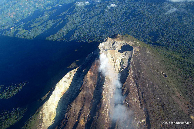 |
Figure 3. Aerial photo taken 13 May 2011 showing summit area craters and deeply incised upper flanks at Sinabung, as seen in the aftermath of the late 2010 eruption. A thin white plume rises from the summit area. Photo posted by Johnny Siahaan. |
This report also includes aspects of the eruption (Siahaan, 2010) during August-September 2010 (BGVN 35:07), including video of the Mt. Sinabung. Johnny Siahaan's video of 30 August 2010 shows a scene with two separate ash plumes rising together (figure 4). The larger plume emitted laterally (almost horizontally) but convection of the hot ash and gasses bent it into the vertical well out over the flank of the volcano. The other plume was initially smaller, escaping from an adjacent but distinct area of the summit, and rising nearly vertically. The two plumes appear to merge at altitude and then bend in the wind. What looks like an older plume in the distance near the beginning of the video rose and was strongly sheared in the wind. The "look direction" of the video was not stated.
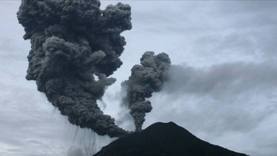 |
Figure 4. Two separate ash plumes rising from two vents at Sinabung. Photo courtesy of Johnny Siahaan's Youtube video, 30 August 2010. |
References: Siahaan, J, Image 1414, Sinabung Flickr (URL: http://www.flickr.com/photos/johnnysiahaan/5735509397/)
Siahaan, J, 30 August 2010, Mount Sinabung Eruption, YouTube video (URL: http://www.youtube.com/watch?v=dMSkvYRxLwA )
Siahaan, J, 30 August 2010, Gunung Sinabung Meletus, YouTube video (URL: http://www.youtube.com/watch?v=dMSkvYRxLwA )
Geological Summary. Gunung Sinabung is a Pleistocene-to-Holocene stratovolcano with many lava flows on its flanks. The migration of summit vents along a N-S line gives the summit crater complex an elongated form. The youngest crater of this conical andesitic-to-dacitic edifice is at the southern end of the four overlapping summit craters. The youngest deposit is a SE-flank pyroclastic flow 14C dated by Hendrasto et al. (2012) at 740-880 CE. An unconfirmed eruption was noted in 1881, and solfataric activity was seen at the summit and upper flanks in 1912. No confirmed historical eruptions were recorded prior to explosive eruptions during August-September 2010 that produced ash plumes to 5 km above the summit.
Information Contacts: Center of Volcanology and Geological Hazard Mitigation (CVGHM), Jalan Diponegoro 57, Bandung 40122, Indonesia (URL: http://vsi.esdm.go.id/).