Report on Agrigan (United States) — May 2013
Bulletin of the Global Volcanism Network, vol. 38, no. 5 (May 2013)
Managing Editor: Richard Wunderman.
Agrigan (United States) 2007 M~3.3 earthquake followed by clouds of equivocal origin
Please cite this report as:
Global Volcanism Program, 2013. Report on Agrigan (United States) (Wunderman, R., ed.). Bulletin of the Global Volcanism Network, 38:5. Smithsonian Institution. https://doi.org/10.5479/si.GVP.BGVN201305-284160
Agrigan
United States
18.77°N, 145.67°E; summit elev. 965 m
All times are local (unless otherwise noted)
Our last report on Agrigan volcano covered a May 1992 field visit (BGVN 17:06) by a six-member team of USGS volcanologists that visited the Commonwealth of the Northern Mariana Islands (CNMI) at the request of the CNMI Office of Civil Defense. The team detected thermal activity, but no seismicity, deformation or other signs of an eruption.
The following came from a report by both the USGS and CNMI issued mid-July 2007and labeled Current Update. "An earthquake was reported felt on Agrigan island at 3:49 pm July 16 local time. About 3 seconds of shaking was reported by a local resident. Seismometers on Sarigan and Anatahan recorded the earthquake and allowed estimation the magnitude at approximately 3.3. No sulfur smell or any other signs of volcanic activity were reported on July 16 or in a follow up call on July 17."
Some 2012 and 2013 observations were equivocal. On 29 February 2012, NOAA's Washington Volcanic Ash Advisory Center (VAAC) inferred ash and gas emissions here for the first time on record, but this was later discounted due to lack of forthcoming evidence. The inferred plume was seen in satellite infrared imagery. It extended 74 km NW from the summit.
A possible volcanic plume from Agrigan was spotted again by the VAAC in a satellite image from 22 January 2013.
In a 25 January 2013 USGS update, it was noted that neither the USGS nor NOAA received confirmation of a volcanic source for the satellite anomalies. The authors of the 2013 update interpreted the cloud as weather-related and not volcanic in origin.
Figure 2 shows a photo of Agrigan taken in June 2013. No hotspots were detected during mid-2012 to mid-2013 by the MODVOLC Thermal Alerts System.
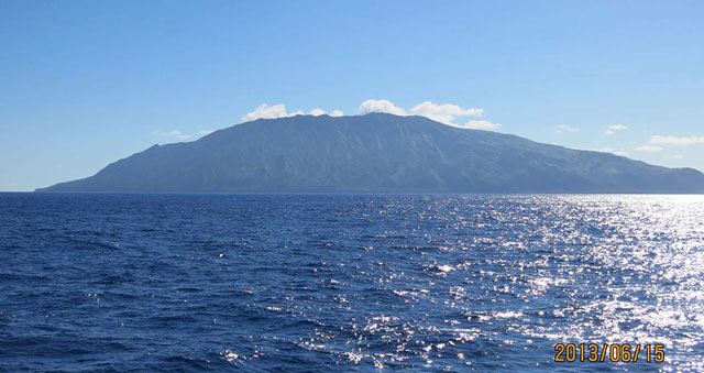 |
Figure 2. Agrigan as seen on 15 June 2013. Photo credit to Yoshi Tamura; featured here thanks to cooperation of Robert Stern. |
Agrigan, the highest-standing stratovolcano and largest (by subaerial volume) in the Northern Mariana Islands, stands 882 m a.s.l (figure 3). The island is ~10 by 6.5 km (N-S by E-W) in size, with a surface area of 52.7 km2. The volcano's subaerial volume is ~15.9 km3. The summit contains a large depression, roughly 1.5 by 1.2 km in diameter, and 380 m deep. A spatter cone and flows from the 1917 eruption cover ~50 percent of the crater floor. This large crater implies a local edifice with shallow magma storage within the volcano. The flanks of the volcano are steep (>30 degrees), with deep furrows extending radially away from the crater. To the north is a large canyon into which a recent, large 'a'ā flow advanced to form a delta on the coast. Pyroclastic flow deposits mantle most of the interior of the island. Rocks erupted on the island range from basalt to andesite. The southwest coast has several beaches composed of mineral sands; otherwise, the coast is rocky. (Trusdell, F.A. and others, 2009).
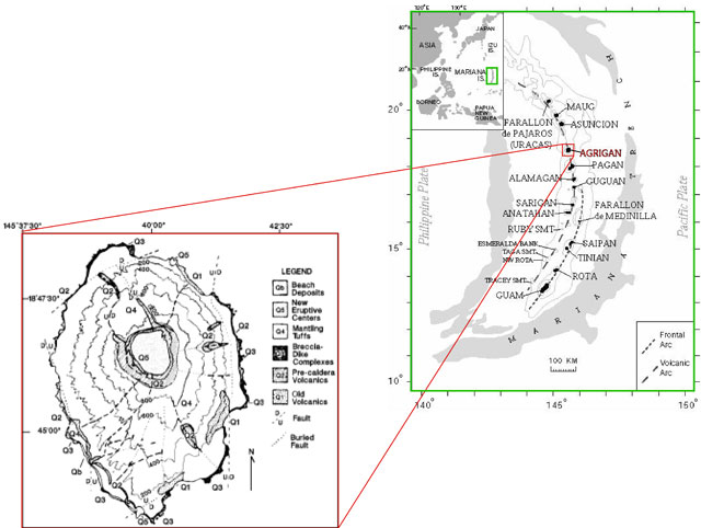 |
Figure 3. Geologic map of Agrigan with 200 m contour intervals (after Stern, 1978) and location map (after Trusdell and others, 2006). |
References. Sako, M. K.; Trusdell, F. A.; Koyanagi, R. Y.; Kojima, George; Moore, R. B., 1995, Volcanic investigations in the Commonwealth of the Northern Mariana Islands, April to May 1994, USGS Open-File Report 94-705.
Stern, R.J., 1978, Agrigan: an introduction to the geology of an active volcano in the Northern Mariana Arc: Bulletin of Volcanology, v. 41, p. 43-55.
Trusdell, F.A., Moore, R.B., and Sako, M.K., 2006. Preliminary Geologic Map of Mount Pagan Volcano, Pagan Island, Commonwealth of the Northern Mariana Islands, USGS Open-File Report 2006-1386 (URL: http://pubs.usgs.gov/of/2006/1386/).
Trusdell, F.A. 2009, Geology of the Mariana Islands, in Gillespie, R.G., and Clague, D.A., eds., Encyclopedia of Islands: Enclyclopedias of the Natural World, 2, University of California Press, Chap. 18. P. 598-603.
Geological Summary. The highest of the Marianas arc volcanoes, Agrigan contains a 500-m-deep, flat-floored caldera. The elliptical island is 8 km long; its summit is the top of a massive 4000-m-high submarine volcano. Deep radial valleys dissect the flanks of the thickly vegetated stratovolcano. The elongated caldera is 1 x 2 km wide and is breached to the NW, from where a prominent lava flow extends to the coast and forms a lava delta. The caldera floor is surfaced by fresh-looking lava flows and also contains two cones that may have formed during the only historical eruption in 1917. This eruption deposited large blocks and 3 m of ash and lapilli on a village on the SE coast, prompting its evacuation.
Information Contacts: Emergency Management Office of the Commonwealth of the Northern Mariana Islands (EMO-CNMI) and USGS Volcano Hazards Program, PO Box 100007, Saipan, MP 96950, USA (URL: http://www.cnmihsem.gov.mp/ and http://volcanoes.usgs.gov/nmi/activity/); Washington Volcanic Ash Advisory Center (VAAC), Satellite Analysis Branch (SAB), NOAA/NESDIS E/SP23, NOAA Science Center Room 401, 5200 Auth Rd, Camp Springs, MD 20746, USA (URL: http://www.ospo.noaa.gov/Products/atmosphere/vaac/); Hawai'i Institute of Geophysics and Planetology (HIGP), MODVOLC Thermal Alerts System, School of Ocean and Earth Science and Technology (SOEST), Univ. of Hawai'i, 2525 Correa Road, Honolulu, HI 96822, USA (URL://httphotspot.higp); Robert J. Stern, University of Texas at Dallas, 800 W Campbell Rd Richardson, TX 75080; and Yoshi Tamura, Institute for Research on Earth Evolution (IFREE), Japan Agency for Marine-Earth Science and Technology (JAMSTEC), Yokosuka 237-0061, Japan.