Report on Pavlof (United States) — May 2013

Bulletin of the Global Volcanism Network, vol. 38, no. 5 (May 2013)
Managing Editor: Richard Wunderman.
Pavlof (United States) Eruption in May-June 2013 with lava flows and ash emissions to ~8.5 km a.s.l.
Please cite this report as:
Global Volcanism Program, 2013. Report on Pavlof (United States) (Wunderman, R., ed.). Bulletin of the Global Volcanism Network, 38:5. Smithsonian Institution. https://doi.org/10.5479/si.GVP.BGVN201305-312030
Pavlof
United States
55.417°N, 161.894°W; summit elev. 2493 m
All times are local (unless otherwise noted)
Pavlof, the most active volcano in the Aleutian arc, erupted on 13 May 2013. Before this, it had most recently erupted on 15 August 2007, following an 11-year period of quiescence. The eruption that began in May 2013 continued through June before slowly subsiding to background levels by 8 August. Pavlof generated several ash plumes during the six-week eruption that disrupted aviation, including an 8-km high plume on 24 June. As in past Pavlof eruptions, the recent eruptions fluctuated in intensity. This report briefly discusses earthquake data during 2007-2011 and, in greater detail, the series of eruptions during May and June 2013.
According to Mangan and others (2009), Pavlof has discharged more than 40 recorded eruptions within the previous 200 years, producing mostly basaltic andesite to andesite products. That work, discussed in a separate subsection near the end of this report, also discusses the adjacent 12x19 km Emmons Lake caldera (a chain of nested calderas) on Pavlof's SW flank (figure 5). The Emmons Lake Volcanic Center (ELCV) is used to collectively describe the entire complex, including the nested caldera, intra-caldera stratovolcanoes, and the adjacent stratovolcanoes (including Pavlof) to the NE.
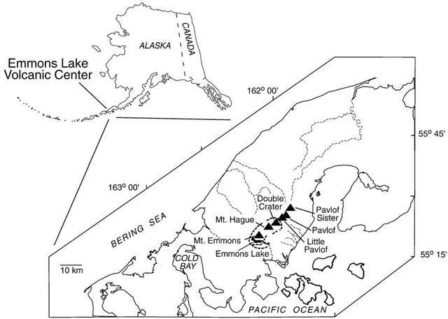 |
Figure 5. Maps showing both the location of Pavlof on the lower Alaska Peninsula (upper left) and showing more details of the complex, including the elongate Emmons Lake caldera and six stratovolcanoes. The lake occupies but a small volume of the caldera, which is breached to the SE. Taken from Mangan and others (2009). |
According to the Alaska Volcano Observatory (AVO), 48 earthquakes were located beneath Pavlof in 2007, the year of the previous eruption. During the following non-eruptive years, AVO reported 9 earthquakes centered at Pavlof in 2008, 7 earthquakes in 2009, 19 in 2010, and 13 in 2011. As of this writing, AVO has not yet published 2012 earthquake data.
Eruption in May 2013. On 13 May 2013, seismicity increased at 0800 and an intense thermal anomaly was observed at the summit in satellite imagery. Several spikes in seismicity occurred between 0900 and 1000. AVO noted that similar patterns of seismicity and elevated surface temperatures in previous cases had signaled the onset of eruptive activity at Pavlof. The Volcanic Alert Level was increased to Watch (the second highest category of four) and the Aviation Color Code was increased to Orange (the second highest category of four).
On 14 May 2013, pilot reports and satellite images indicated a spatter-fed lava flow that had advanced about 0.5 km down the N flank. The advancing lava had also generated debris-laden deposits, presumably from the interaction of hot lava with snow and ice on the flank. According to AVO, a diffuse ash plume drifted about 160 km NE at an altitude of 4.6 km before dissipating. Minor ashfall was reported the evening of 14 May in a mining camp 80 km NE of the volcano. No other nearby communities reported ashfall. Minor steam-and-ash emissions from the summit were visible from Cold Bay (~58 km SW).
During 14-15 May 2013, elevated seismicity persisted. Steam-and-ash clouds observed with a web camera at Cold Bay (55 km W of the volcano) occasionally rose to an altitude of 6.1 km. Residents in Cold Bay observed incandescence from the summit during the night. On 15 May a pilot reported a dark ash cloud drifting ENE at an altitude of 6.1 km.
On 16 May, AVO observed lava fountaining at the summit and a continuous ash, steam, and gas cloud extending 50-100 km downwind at an altitude of about 6.1 km. Satellite images showed persistent elevated surface temperatures at the summit and on the NW flank, consistent with lava fountaining at the summit and the resulting lava flow.
During 18-19 May 2013, reports noted that a narrow plume of steam, ash, and gas occasionally rising up to an altitude of 6.7 km and drifting SE was visible in satellite and pilot images (figures 6 and 7). Pilots noted that lava fountaining and ash emission continued. Overnight, trace amounts of ash fell on the community of Sand Point (88 km E). During the afternoon on 19 May, pilots reported that ash plumes rose to altitudes of 4.6-6.7 km. Trace amounts of ash fell in Nelson Lagoon (78 km NNE) during 19-20 May.
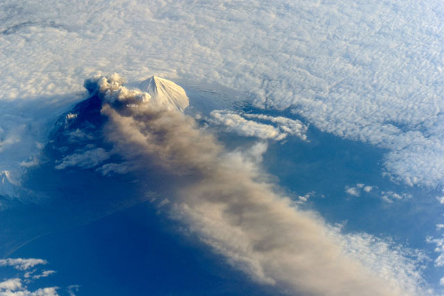 |
Figure 6. Photograph of Pavlof taken on 18 May 2013 by astronauts aboard the International Space Station. The space station was ~770 km away and S-SE of the volcano when the photograph was taken. The volcanic plume extended SE over the North Pacific Ocean. Residing next to Pavlof is the white, seemingly ash free stratovolcano Pavlof Sister. Courtesy of NASA Earth Observatory with credit for caption and processing to Robert Simmon, (NASA Earth Observatory) and G. M. Gentry (DB Consulting Group at NASA-JSC). |
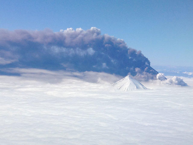 |
Figure 7. Photo of Pavlof eruption taken by a commercial pilot on 18 May 2013. Plume direction was not identified, but based on the NASA photo taken the same day (figure 6), the plume is drifting SE and the volcano in the foreground is Pavlof Sister (NE of Pavlof). Courtesy of Brandon Wilson (PenAir) and provided by AVO/Alaska Division of Geological & Geophysical Surveys. |
News articles (Associated Press, PRNewswire, Alaska Dispatch) stated that during 19-21 May 2013 two regional airlines canceled flights to several remote communities and delayed or re-routed other flights. On 21 May AVO reported that a low-level plume of steam, gas, and ash occasionally rose to an altitude of 6.1 km and drifted NNE. Trace amounts of ash again fell in Nelson Lagoon.
AVO reported that seismic tremor markedly declined around 1100 on 21 May 2013 and was followed through 23 May by the detection of small discrete events, likely indicative of small explosions, by an infrasonic pressure sensor (Chaparral model 2.5 at site PN7). Although cloud cover prevented satellite observations, elevated surface temperatures at the vent were detected. On 22 May a pilot report and photographs indicated weak steam-and-gas emissions containing little to no ash.
The eruption continued at a lower level during 24-26 May. Neither evidence of elevated surface temperatures nor a plume were observed in partly clear satellite images during 24-25 and 27 May. Clouds obscured views on 26 May. The Volcanic Alert Level was lowered to Advisory and the Aviation Color Code was lowered to Yellow on 28 May.
According to AVO, Pavlof emitted ash on 4 June at about 1100, as observed in satellite images and by pilots. Satellite images showed an ash cloud drifting SE, and pilots estimated that the cloud was at an altitude of 5.8 km. Weak seismicity that began at 1057 accompanied the emissions, and then continued. AVO increased the Volcanic Alert Level to Watch and increased the Aviation Color Code to Orange.
AVO reported that ash emissions continued during 5-11 June 2013, accompanied by tremor and explosion signals. Overnight during 4-8 June, satellite images detected elevated surface temperatures near the vent consistent with lava effusion and fountaining. Elevated surface temperatures persisted until 14 June. On 5 and 6 June, an ash plume drifted 40-45 km W and SW at altitudes of 4.3-5.5 km based on pilot estimates. During 8-10 June, an ash plume drifted 20-53 km SE. During 12-14 June, ash emissions were intermittent and minor; ash plumes remained below an altitude of 6.1 km and mostly drifted SE.
During 14-15 June 2013, seismicity decreased. Minor emissions probably ceased, but web-camera views were partially obscured by clouds. On 17 June no plumes were visible in satellite images, and web camera views showed mostly cloudy conditions.
During 17-18 June, tremor amplitude increased slightly, and elevated surface temperatures were again detected in satellite images. A small ash plume rose from the crater. The eruption continued during 19-25 June, with tremor and occasional explosions. Cloud cover prevented web camera views. Elevated surface temperatures continued to be detected during 19-20 and 24 June. A small ash plume from the summit vent was also detected in a satellite image on 19 June, and possibly during 20-22 June.
On 24 June, seismicity increased to the strongest level to date during 2013 and included continuous intense tremor and frequent small explosions likely associated with lava fountaining and ash production. Seismicity remained high on 25 June. Satellite images and pilot observations indicated that a plume drifted W at altitudes as high as 8.2-8.5 km. Satellite images also detected a strong thermal anomaly at the summit. Trace amounts of ash fell in King Cove (48 km SW). According to a news report (Reuters), regional air traffic was again cancelled or re-routed.
According to AVO, seismicity declined during 25-26 June and consisted of intermittent bursts of tremor and occasional small explosions. Satellite images showed a plume containing small amounts of ash drifting NW, and strong thermal anomalies at the summit. Pilot reports on 26 June indicated that plumes rose to altitudes between 6.1-7.6 km during the morning and then to heights just above the summit later that day. Seismicity during 26 June-1 July continued at low levels and consisted primarily of intervals of continuous, low-level tremor. Thermal anomalies at the summit detected in satellite images were strong during 26-29 June and weak during 30 June-1 July.
AVO reported that activity further declined during 1-2 July; tremor and explosions were no longer detected in seismic and pressure sensor data. Satellite images did not detect elevated surface temperatures, volcanic gas, or ash emissions, and there were no visual observations from pilots or from webcam images of any eruptive activity since 26 June. Consequently, AVO lowered the Aviation Color Code to Yellow and the Volcano Alert Level to Advisory.
On 8 August, AVO reported that no lava or ash emissions had been observed at Pavlof since 26 June and the volcano had exhibited gradually declining levels of unrest. Seismicity was at background levels. Thus, AVO lowered the Aviation Color Code to Green and the Volcano Alert Level to Normal.
Mangan and others (2009) discussion. Mangan and others (2009) cite Power and others (2004) as stating that background (non-eruptive) seismicity at Pavlof occurs as infrequent long-period earthquakes at focal depths between 20-40 km. Mangan and others contend that while only a few of these events at most occur annually, they are a stable feature attributed to quasi-steady fluxing of basaltic magma and exsolved CO2 in a deep dike and sill complex. According to the article, the seismic network at Pavlof is poorly situated to detect deep seismicity under the Emmons Lake caldera.
Mangan and others state, "All witnessed [Emmons Lake Volcanic Center] ELVC eruptions have occurred outside the caldera [,specifically] at Pavlof, the most active volcano in the entire arc. Pavlof's slopes are extensively mantled with tephra and pyroclastic debris produced during [its] historical strombolian, vulcanian, and lava fountain events (Miller et al., 1998). Limited precursory seismicity herald Pavlof eruptions (McNutt, 1989) and, to the extent studied, negligible precursory ground deformation (Lu et al., 2003; Z. Lu personal communication 2008). Of the 20 eruptions occurring since the installation of Pavlof's seismic network (1973), 13 eruptions have occurred with less than 24 h of warning. Pavlof is essentially an "open vent" volcano with magma rising aseismically through a thermally well-groomed conduit. High-frequency volcano-tectonic earthquakes, characteristic of magma rise through brittle crust, are virtually absent."
Figure 8 presents Mangan and others (2009) conceptualization of the plumbing beneath the ELVC, which includes Pavlof.
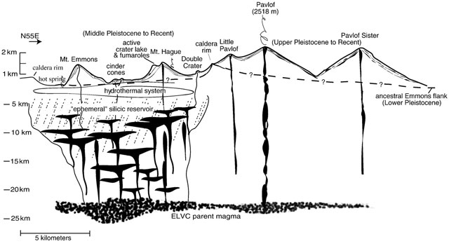 |
Figure 8. Conceptual cross-section through the Emmons Lake Volcanic Center looking at a vertical plane parallel to the volcanic axis. The drawing shows two distinct plumbing systems drawing from a common magmatic source at more than 20 km depth. Courtesy of Mangan and others (2009). |
The other volcano of the ELVC considered to have high likelihood of eruption is Mt. Hague (Waythomas and others, 2006). That study also presents a set of hazard maps for the complex.
References. Mangan, M., Miller, T., Waythomas, C., Trusdell, F., Calvert, A., and Layer, P., 2009, Diverse lavas from closely spaced volcanoes drawing from a common parent: Emmons Lake Volcanic Center, Eastern Aleutian Arc, Earth and Planetary Science Letters, Vol. 287, pp. 363-372.
Waythomas, CF; Miller, TP, and Mangan, MT, 2006, Preliminary Volcano Hazard Assessment for the Emmons Lake Volcanic Center, Alaska, U.S. Geological Survey Scientific Investigations Report 2006-5248 (URL: http://pubs.usgs.gov/sir/2006/5248/).
Geological Summary. The most active volcano of the Aleutian arc, Pavlof is a Holocene stratovolcano that was constructed along a line of vents extending NE from the Emmons Lake caldera. Pavlof and Pavlof Sister to the NE form a dramatic pair of symmetrical, glacier-covered stratovolcanoes that overlook Pavlof and Volcano bays. Little Pavlof is a smaller cone on the SW flank of Pavlof volcano, near the rim of Emmons Lake caldera. Unlike Pavlof Sister, eruptions have frequently been reported from Pavlof, typically Strombolian to Vulcanian explosive eruptions from the summit vents and occasional lava flows. The active vents lie near the summit on the north and east sides. The largest recorded eruption took place in 1911, at the end of a 5-year-long eruptive episode, when a fissure opened on the N flank, ejecting large blocks and issuing lava flows.
Information Contacts: Alaska Volcano Observatory (AVO), a cooperative program of a)U.S. Geological Survey, 4200 University Drive, Anchorage, AK 99508-4667 USA (URL: http://www.avo.alaska.edu/), b)Geophysical Institute, University of Alaska, PO Box 757320, Fairbanks, AK 99775-7320, USA, and c)Alaska Division of Geological & Geophysical Surveys, 794 University Ave., Suite 200, Fairbanks, AK 99709, USA (URL: http://www.dggs.alaska.gov/); Associated Press (URL: http://www.ap.org/); PRNewswire (URL: http://www.prnewswire.com); Alaska Dispatch (URL: http://www.alaskadispatch.com/); and Reuters (URL: http://www.reuters.com/).