Report on Lobster (Tonga) — June 2013

Bulletin of the Global Volcanism Network, vol. 38, no. 5 (June 2013)
Managing Editor: Richard Wunderman.
Lobster (Tonga) Hydrothermally active submarine volcano found in 2008
Please cite this report as:
Global Volcanism Program, 2013. Report on Lobster (Tonga) (Wunderman, R., ed.). Bulletin of the Global Volcanism Network, 38:5. Smithsonian Institution. https://doi.org/10.5479/si.GVP.BGVN201306-243112
Lobster
Tonga
15.333°S, 176.283°W; summit elev. -1500 m
All times are local (unless otherwise noted)
The Australian Commonwealth Scientific and Industrial Research Organization (CSIRO) announced in press releases that several large active submarine volcanoes, spreading ridges, and rift zones had been discovered in the Northwest Lau back-arc basin, NE of Fiji Island (figure 1). The discoveries were made by a team of Australian and American scientists aboard the CSIRO Marine National Facility Research Vessel Southern Surveyor in Spring 2008 (CSIRO, 2008a). While mapping previously uncharted areas for submarine volcanic and hot spring activity, the team located several volcanoes, one of which they named Lobster. The depth of Lobster is given as 1,500 m in the InterRidge Vents Database [Ver. 3.1] (2013). The location of Lobster is shown in figure 1, based on coordinates given in Lupton and others (2012). The base maps in figure 1 came from Keller and others (2008), a study primarily discussing the area in the rectangle on the larger map. The sea floor was mapped with multibeam sonar. Lobster is located ~75 km NNW of Niuafo'ou volcano/island and ~680 km NE of Suva, Fiji (figure 1). Dugong volcano lies ~60 km E of Lobster.
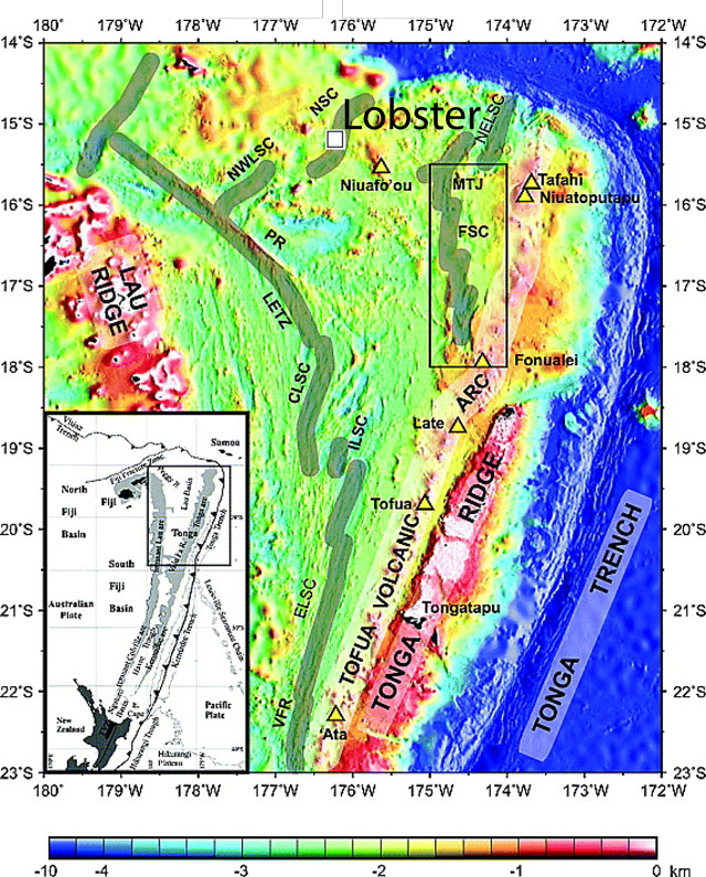 |
Figure 1. Two maps showing (lower left) North Island, New Zealand (in black) and selected plate tectonic features along the Kermadec and Tonga trenches (hachured line with teeth on upthrown side) and (larger map) Lobster (white square) and other features such as the main spreading centers, geographical features, and subaerial volcanoes (open yellow triangles). Note Niuafo'ou volcano and island, and the location of Lobster (and Dugong, a neighboring volcano discussed in a separate Bulletin report and plotted on a larger map). Abbreviations are as follows: VFR - Valu fa ridge; ELSC - East Lau spreading center; ILSC - Intermediate Lau spreading center; CLSC - Central Lau spreading center; LETZ - Lau Extentional transform zone; PR - Peggy Ridge; NWLSC - Northwest Lau spreading center; NSC - Niuafo'ou spreading center (location of Rochambeau Rifts); NELSC - Northeast Lau spreading center; FSC - Fonualei spreading center; and MTJ - Mangatolu triple junction. Courtesy of Keller and others (2008). |
Lobster volcano's caldera is 2x2.5 km in diameter with a floor at 1.5 km depth (figure 2). It was described as residing amid four radiating rift zones.
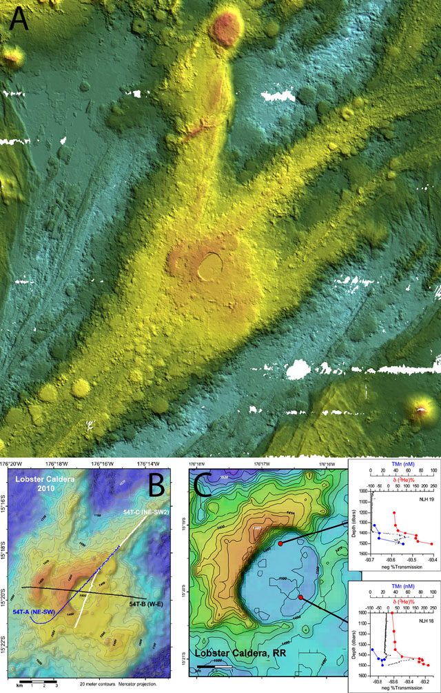 |
Figure 2. (a) Multibeam sonar three-dimensional (30 kHz swathmap) image made in 2008 of Lobster which sits in what was described as the center of a rift zone and astride a spreading ridge to its W (CSIRO, 2008). Image lacks scale for depth values, but in relative terms light blue is the deepest, trending upwards through dark-to-light green, yellow, orange, and then red as the shallowest. Image from news release of CSIRO (2008b). (b) Shaded relief, contour map of Lobster caldera on the Rochambeau rifts showing part of a survey track completed in 2010 by the research vessel Dorado Discovery. Taken from Lupton and others (2012). (c) Detail map of Lobster Caldera showing locations and profiles for two chemistry hydrocasts. Inserts show vertical profiles of δ3He (deviation of the 3He/4He ratio measured at depth from the atmospheric ratio), total Mn (manganese), and %T transmission of light (a measure of suspended particles) plotted versus depth. Taken from Lupton and others (2012). |
The caldera's rim is about 100 m high on the W side whereas only ~20 m high on the E side.
Dredge samples from Lobster recovered in 2008 contained olivine and plagioclase in pillow basalts. A dredge sample taken on the smooth caldera floor recovered fresh flows as well as thick, black aphyric pillows with glassy rinds.
Age. According to Arculus (2008) and Lupton and others (2012), active venting was identified in the form of high helium anomalies (δ3He), suspended particles (%T), and trace metals (manganese and iron) at 60 m off the bottom in the SE corner of the summit caldera. Lupton and others (2012) reported, in 2012, that the site was still active.
The expedition mapped the seafloor using a 30 kHz multibeam sonar with Global Positioning System (GPS) and an Inertial Motion Unit (IMU) to track the ship's position and attitude. They also made vertical conductivity, temperature, and depth (CTD) measurements as well as rock dredging. In addition, by lowering the CTD package up and down a few hundred meters from the bottom, while moving the ship, they obtained a far greater density of data. This technique, often informally referred to as a CTD tow-yo, is effective for mapping and sampling hydrothermal plumes.
References. Arculus, R.J., 2008, Marine National Facility RV Southern Survey 2008 Program: Voyage Summary SS07/2008 Northern Lau Vents Expedition (NoLauVE), 23 p (URL: http://www.cmar.csiro.au/datacentre/process/data_files/cruise_docs/SS200807sum.pdf).
CSIRO, 2008a, Active submarine volcanoes found near Fiji, CSIRO web site (URL: http://www.csiro.au/Organisation-Structure/Divisions/Earth-Science--Resource-Engineering/SubmarineVolcanoes.aspx).
CSIRO, 2008b, Active submarine volcanoes found near Fiji, CSIRO media release (URL: http://www.scienceimage.csiro.au/mediarelease/mr08-93.html).
de Ronde, C.E.J, Baker, ET, Massoth, G.J, Lupton, J.E, Wright, I.C., Feely, R.A., and Greene, R.R., 2001, Intra-oceanic subduction-related hydrothermal venting, Kermadec volcanic arc, New Zealand, Earth and Planetary Science Letters, v. 193, p. 359-369.
Graham, I.J., Reyes, A.G., Wright, I.C., Peckett, K.M., Smith, I.E.M., and Arculus, R.J., 2008, Structure and petrology of newly discovered volcanic centers in the northern Kermadec–southern Tofua arc, South Pacific Ocean, Journal of Geophysical Research, v. 113, B08S02, doi:10.1029/2007JB005453.
InterRidge Vents Database Ver. 3.1, 2013, Vent Fields (URL: http://www.interridge.org/irvents/ventsfields?).
Keller, N.S., Arculus, R.J., Hermann, J., and Simon, R., 2008, Submarine back-arc lava with arc signature: Fonualei Spreading Center, northeast Lau Basin, Tonga, Journal of Geophysical Research, v. 113, B08S07, doi:10.1029/2007JB005451.
Lupton, J.E., Arculus, R.J., Resing, J., Massoth, G.J., Greene, R.R., Evans, L.J., and Buck, N., 2012, Hydrothermal activity in the Northwest Lau Backarc Basin: Evidence from water column measurements, Geochemistry, Geophysics, Geosystems, v. 13, no. 5, doi: 10.1029/2011GC003891.
Geological Summary. Active hydrothermal venting was noted when this volcano was first discovered in 2008 by an Australian research expedition.
Information Contacts: Commonwealth Scientific and Industrial Research Organization (CSIRO) (URL: http://www.csiro.au).