Report on Kelimutu (Indonesia) — June 2013
Bulletin of the Global Volcanism Network, vol. 38, no. 6 (June 2013)
Managing Editor: Richard Wunderman.
Kelimutu (Indonesia) Crater water boils; diffuse, white plume increases to 50 m
Please cite this report as:
Global Volcanism Program, 2013. Report on Kelimutu (Indonesia) (Wunderman, R., ed.). Bulletin of the Global Volcanism Network, 38:6. Smithsonian Institution. https://doi.org/10.5479/si.GVP.BGVN201306-264140
Kelimutu
Indonesia
8.77°S, 121.82°E; summit elev. 1639 m
All times are local (unless otherwise noted)
This volcano is well known for three summit crater lakes, each a different color. We last reported minor bubbling in a crater lake Tiwu Nua Muri Kooh Tai lake in 1995 (BGVN 20:06). Between 15 and 19 May 1995, rescuers searched for the body of a Dutch tourist who had fallen into the crater lake but they did not find it.
2013 activity.The Center of Volcanology and Geological Hazard Mitigation (CVGHM) reported that on 6, 10, and 12 June 2013, and during 14 June-9 July 2013, the color of the water in Kelimutu's Crater II (Tiwu Nua Muri Kooh Tai Crater) was bluish white. Diffuse white plumes rose as high as 50 m above the lake's surface and in some areas the water appeared or sounded like it was boiling. A sulfur odor was also reported. The water in Crater I (Tiwu Ata Polo) was light green and churned, and the water in Crater III (Tiwu Ata Mbupu) was mossy green.
On 3 June 2013, a change was observed in the color of the lake water in Crater II, going from blue to a café au lait (light tan), accompanied by white smoke under weak to medium pressure, rising 50 meters above the surface of the lake. From the southern side of Crater II a bubbling sound of boiling was heard near the wall separating Crater I from Crater II. The smell of sulphur gas was quite sharp in the vicinity of the crater and at nighttime a weak to medium smell of this gas could be discerned in Pemo Village which is 3 kms from the peak of Kelimutu. On 4 June 2013 at 1400 hours local time the status of Kelimutu was upgraded from Alert Level 1 (Normal) to Alert Level 2 (Waspada).
On 6 June 2013 water in Crater II was a bluish white (like a salty egg), with sparse to medium white smoke under weak to strong pressure extending up 10-35 meters above the lake surface. A weak to strong bubbling sound of boiling water was heard on the southern side of the crater. A medium to sharp smell of sulphurous gas was evident as was the withering vegetation.
On 10 June 2013 water in Crater II was still a bluish white with medium to dense white smoke extending up 40-50 m above the lake surface. A bubbling sound of boiling water could be heard on the southern side of the crater. A medium smell of sulphurous gases was discernible.
On 12 June 2013, smoke rising from the surface of the lake extended to only about 10-30 meters above the lip of the crater. There was a rather acrid smell of sulphurous fumes. Eruptive and hot air noises were audible two times and the water in the crater lake still appeared to be boiling.
From 14 June to 9 July 2013, water in Crater II visually still appeared bluish white with sparse white smoke rising from the surface of the lake about 2-10 meters into the atmosphere (dominant height was not observed). There was a weak to medium (with weak dominating) smell of sulphurous gases. At one point bubbling water was noticeable but it was clearly under weak pressure. Water from Crater III was calm and moss-green in color.
During 22-29 June 2013 sulfur dioxide concentrations in Crater II were occasionally 2.8 ppm, when the wind blew the gas towards the sensor. CVGHM noted that plumes rising from the lakes became lower and barely visible during 3 June-9 July, and that the hissing or "rustling sound" of water from near the dividing wall of craters I and II had gradually faded away. Based on visual observations, seismicity, and gas emissions, CVGHM lowered the Alert Level to 1 (on a scale of 1-4) on 12 July (figure 4).
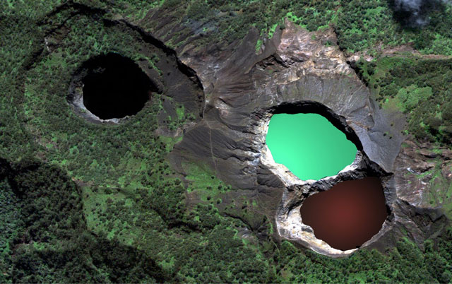 |
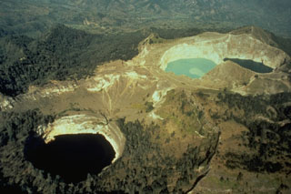
Figure 4. Kelimutu has three summit crater lakes seen in this photo. The lake Tiwi Ata Mbupu (left) is commonly blue. Tiwu Nua Muri Kooh Tai and Tiwu Ata Polo, which share a common crater wall, are typically green and red-colored, respectively. Photo courtesy of https://www.tripping.com. Posted 1 June 2013. |
During 13 - 18 June 2013, local tectonic quakes peaked at 139 before undergoing a decrease as of 17 June 2013. Shallow (VB) and deep (VA) volcanic earthquakes occurred intensely each day, reaching a a peak of 13 shallow volcanic quakes 19-24 June 2013 and then tended to decline (figure 5). Deep volcanic quakes peaked at 14 during 1-6 July 2013 and then subsided.
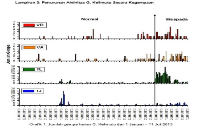 |
Figure 5. A plot of seismicity at Kelimutu during 1 June 2013 through 11 July 2013. Courtesy of CVGHM. |
No thermal alerts were recorded by MODVOLC for the past twelve months beginning in mid-July 2012.
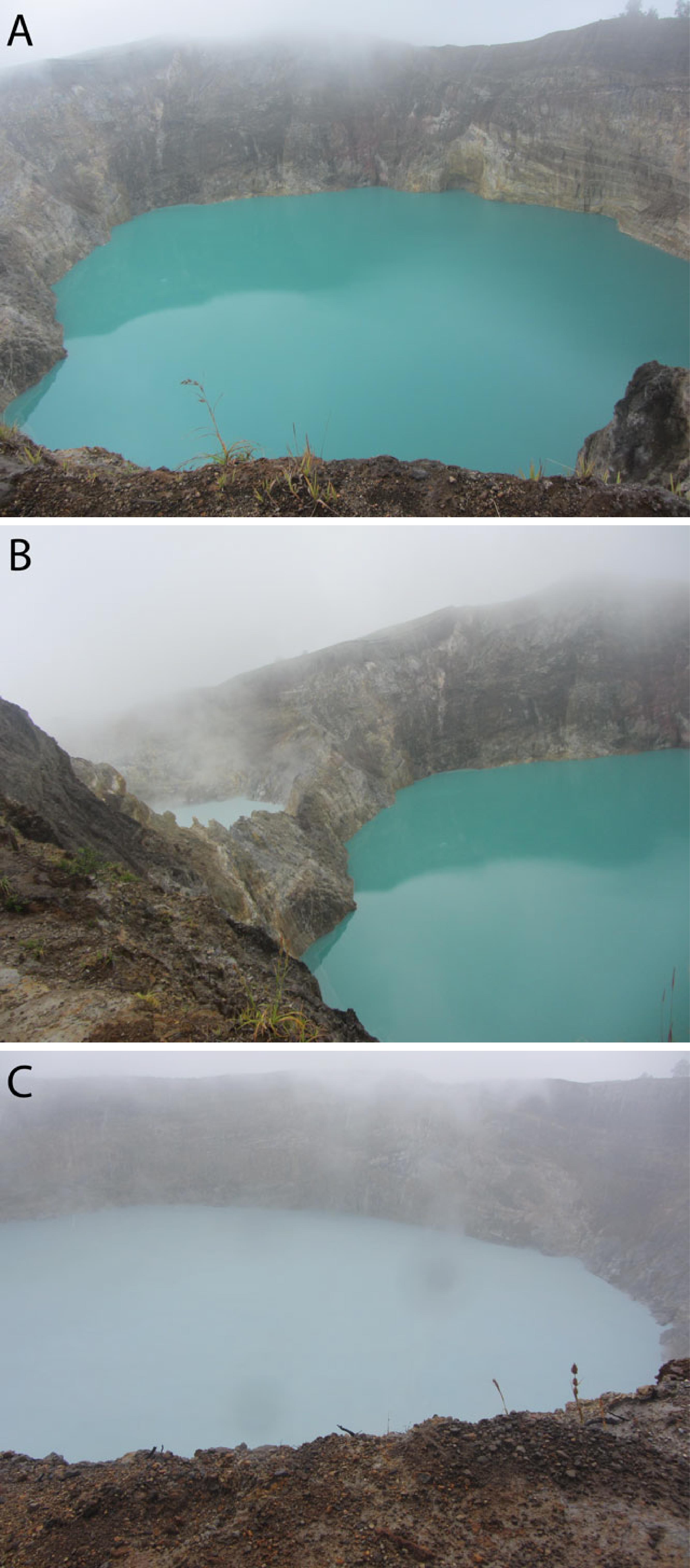 |
Figure 6. First photo (A) is Tiwu Ata Polo Lake (water color change from red to green), second photo (B) is between Tiwu Ata Polo Lake and Tiwu Nua Muri Kooh Fai Lake, and third photo (C) is Tiwu Nua Muri Kooh Fai Lake (water color change from green to white). Pictures taken on 6 June 2013 by Kristianto. |
Geological Summary. Kelimutu is a small, but well-known, Indonesian compound volcano in central Flores Island with three summit crater lakes of varying colors. The western lake, Tiwi Ata Mbupu (Lake of Old People) is commonly blue. Tiwu Nua Muri Kooh Tai (Lake of Young Men and Maidens) and Tiwu Ata Polo (Bewitched, or Enchanted Lake), which share a common crater wall, are commonly colored green and red, respectively, although lake colors periodically vary. Active upwelling, probably fed by subaqueous fumaroles, occurs at the two eastern lakes. The scenic lakes are a popular tourist destination and have been the source of minor phreatic eruptions in historical time. The summit is elongated 2 km in a WNW-ESE direction; the older cones of Kelido (3 km N) and Kelibara (2 km S).
Information Contacts: Center of Volcanology and Geological Hazard Mitigation (CVGHM), Jalan Diponegoro 57, Bandung 40122, Indonesia (URL: http://www.vsi.esdm.go.id/); and Hawai'i Institute of Geophysics and Planetology (HIGP) MODVOLC Thermal System, School of Ocean and Earth Science and Technology (SOEST), Univ. of Hawai'i, 2525 Correa Road, Honolulu, HI 96822 USA (URL: http;//hotspot.higp.hawaii.edu/).