Report on Ubinas (Peru) — August 2013

Bulletin of the Global Volcanism Network, vol. 38, no. 8 (August 2013)
Managing Editor: Richard Wunderman.
Ubinas (Peru) Explosions during 1-7 September 2013 produce ash plumes
Please cite this report as:
Global Volcanism Program, 2013. Report on Ubinas (Peru) (Wunderman, R., ed.). Bulletin of the Global Volcanism Network, 38:8. Smithsonian Institution. https://doi.org/10.5479/si.GVP.BGVN201308-354020
Ubinas
Peru
16.345°S, 70.8972°W; summit elev. 5608 m
All times are local (unless otherwise noted)
During 2008 through August 2009 Ubinas emitted persistent fumarolic plumes and had intermittent ash explosions (BGVN 35:04). This activity led to frequent aviation warnings. The current report discusses a phreatic eruption during 1-7 September 2013 that included nine explosions. The location of Ubinas, the most active volcano in Peru, is shown in figure 18.
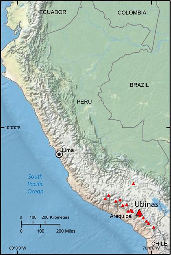 |
Figure 18. Map of Peru showing the location of Ubinas. Courtesy of USGS. |
Between the beginning of September 2009 and the end of August 2013, the Buenos Aires Volcanic Ash Advisory Center (VAAC) reported two additional ash plumes in aviation warnings on 18 July 2010 and [11 July 2013]. According to a pilot report, the [11 July 2013] plume rose to an altitude of 5.5 km and drifted W; however, no ash was detected in satellite images amid clear conditions. The IGP did not report any increase in the earthquake number on 4 July, but indicated that the seismic energy liberated increased significantly on that date, from about 24-58 megajoules during 1-3 July to 74 megajoules before decreasing to 37 on 5 July and remained between 5 and 22 megajoules through 15 July 2013.
The Instituto Geofísico del Perú (IGP) and the Observatorio Volcanológico del INGEMMET (OVI-INGEMMET) reported that a phreatic eruption at Ubinas beginning 1 September 2013 included nine explosions (figure 19). According to a news account (The Raw Story) seismologist Victor Aguilar of the Geophysical Institute of the University of San Agustin de Arequipa told the Agence France-Presse that the first explosion was strong and was followed by a series of lesser blasts. Most of the explosions generated ash plumes that rose 1.5 2 km above the crater. A brief description of the explosions is presented in table 6. IGP monitors Ubinas continuously with a network of four telemetered stations. Figure 20 shows the fourth explosion, seen on 3 September 2013.
Table 6. Description of the explosions at Ubinas during 1-7 September 2013, and another ash emission on 22 October 2013. MJ is megajoules. ND is not determined as of 27 September. Courtesy of IGP and OVI INGEMMET.
| Explosion | Date and local time | Energy (MJ) | Duration (sec) | Comments |
| 1 | 1 Sep, 2246 | 1765 | 110 | Ballistics up to 2 m in diameter ejected, minor ashfall 2 km ENE. |
| 2 | 2 Sep, 1552 | 666 | 292 | Fewer ballistics than first explosion. Large gas and ash plume to 2 km above crater. |
| 3 | 2 Sep, 2350 | 122 | 279 | Ash plume |
| 4 | 3 Sep, 0809 | 139 | 296 | Gas and ash plume up to 2 km above crater; minor ashfall >40 km NW affected small towns. |
| 5 | 3 Sep, 1021 | 58 | 288 | Gas and ash plume to 1.6 km above crater |
| 6 | 3 Sep, 1029 | 313 | 74 | Gas and ash plume to 1.6 km above crater |
| 7 | 4 Sep, 1807 | 505 | 350 | -- |
| 8 | 5 Sep, 1620 | 191 | 321 | -- |
| 9 | 7 Sep, 1036 | ND | ND | -- |
| 10 | 22 Oct | ND | ND | Non-explosive gas-and-ash emissions |
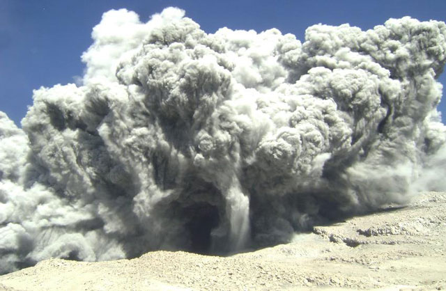 |
Figure 19. Photo showing the gas and ash plume from Explosion 2 of the phreatic eruption at Ubinas, which was taken on 2 September 2013. Courtesy of IGP and OVI-INGEMMET. |
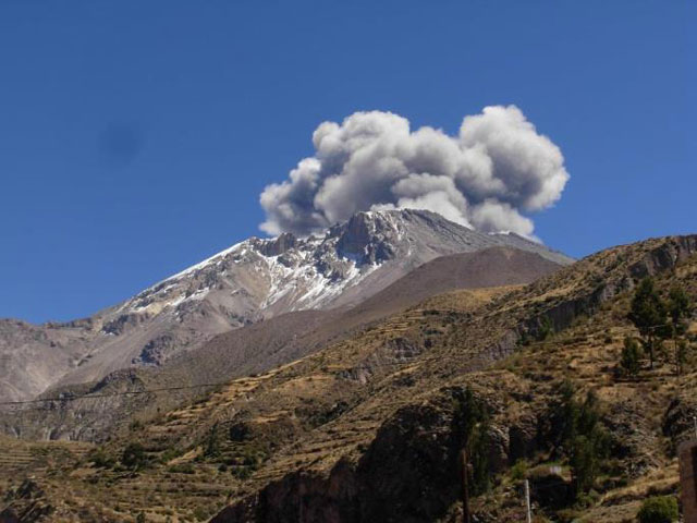 |
Figure 20. Photo of Explosion 4 of the phreatic eruption at Ubinas, taken on 3 September 2013. Courtesy of IGP and OVI INGEMMET. |
Sulfur dioxide (SO2) concentrations were measured with a mini-DOAS spectrometer, shortly after Explosion 4; the average SO2 concentration was 155 metric tons/day.
According to a news account (Phys.org), on 12 September 2013, Peru declared a state of emergency in nine districts threatened by the toxic gases and ash spewing from Ubinas. Authorities were distributing masks and have given themselves a 60 day period to relocate villagers from areas where ash is damaging crops and polluting water sources.
Geological Summary. The truncated appearance of Ubinas, Perú's most active volcano, is a result of a 1.4-km-wide crater at the summit. It is the northernmost of three young volcanoes located along a regional structural lineament about 50 km behind the main volcanic front. The growth and destruction of Ubinas I was followed by construction of Ubinas II beginning in the mid-Pleistocene. The upper slopes of the andesitic-to-rhyolitic Ubinas II stratovolcano are composed primarily of andesitic and trachyandesitic lava flows and steepen to nearly 45°. The steep-walled, 150-m-deep summit crater contains an ash cone with a 500-m-wide funnel-shaped vent that is 200 m deep. Debris-avalanche deposits from the collapse of the SE flank about 3,700 years ago extend 10 km from the volcano. Widespread Plinian pumice-fall deposits include one from about 1,000 years ago. Holocene lava flows are visible on the flanks, but activity documented since the 16th century has consisted of intermittent minor-to-moderate explosive eruptions.
Information Contacts: Buenos Aires Volcanic Ash Advisory Center (VAAC), Servicio Meteorológico Nacional Fuerza Aérea Argentina, 25 de mayo 658, Buenos Aires, Argentina (URL: http://www.smn.gov.ar/vaac/buenosaires/productos.php); Instituto Geofísico del Perú (IGP) (URL: http://www.igp.gob.pe); Instituto Geológical Minero y Metalúrgico (INGEMMET), Av. Canadá 1470, San Borja, Lima 41, Perú (URL: http://www.ingemmet.gob.pe/);
USAID USGS Volcano Disaster Assistance Program (VDAP) (URL: http://volcanoes.usgs.gov/vdap/); phys.org (URL: phys.org); and The Raw Story (URL: www.rawstory.com).