Report on Sinabung (Indonesia) — September 2013

Bulletin of the Global Volcanism Network, vol. 38, no. 9 (September 2013)
Managing Editor: Richard Wunderman.
Sinabung (Indonesia) 17,000 evacuees as mid- to late-2013 eruption emits pyroclastic flows
Please cite this report as:
Global Volcanism Program, 2013. Report on Sinabung (Indonesia) (Wunderman, R., ed.). Bulletin of the Global Volcanism Network, 38:9. Smithsonian Institution. https://doi.org/10.5479/si.GVP.BGVN201309-261080
Sinabung
Indonesia
3.17°N, 98.392°E; summit elev. 2460 m
All times are local (unless otherwise noted)
In several issues of the Bulletin (BGVN 35:07, 36:03, and 38:04) we described the first confirmed eruption at Sinabung volcano (figure 1), which began 27 August 2010. This report notes ongoing eruptions along with more evacuations, more pyroclastic flows, and plumes as tall as 10 km.
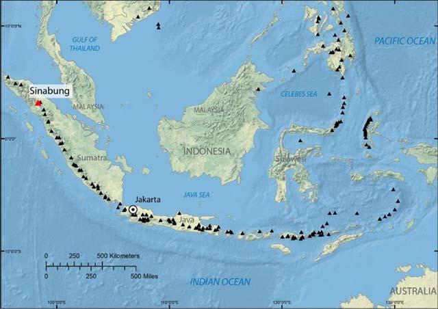 |
Figure 5. A map centered on Indonesia, showing the location of Sinabung volcano on Sumatra Island near the NW end of the long line of active volcanoes (black triangles) in that country. Sinabung lies 35 km NNW from the nearest margin of the crater lake of Toba, the largest identified volcanic caldera on Earth. Courtesy of U.S. Geological Survey. |
The Indonesian Center of Volcanology and Geological Hazard Mitigation (CVGHM) reported that seismicity at Sinabung fluctuated during 2012 and through September 2013. During early September 2013, dense white plumes rose 100-150 m above the crater, and, on 14 September, incandescence from the crater was observed. Although this and several other instances of incandescence from the volcano's crater were reported during this eruption period, no MODVOLC thermal alerts were measured.
An estimated 16,000 people live within 10 km of the Sinabung volcano. Many photos of the volcano during this eruption can be found in an article from The Atlantic (Taylor, 2013). Some of the photos disclosed plumes otherwise little documented.
According to news articles, an eruption at 0245 on 15 September produced an ash plume and ashfalls in the towns of Sukameriah (50 km NE), Kutarayat (location uncertain), Kutagugung (16 km SW), and Berastagi (14 km E). About 6,000 people were evacuated from areas within a 3-km radius of the volcano, and several flights at Medan's airport (55 km NW) were canceled. CVGHM raised the Alert Level to III.
An eruption at 1203 on 17 September 2013 ejected tephra and a dense ash plume that rose higher than the plume seen on 15 September. According to the Darwin VAAC, on 17 September, a pilot observed an ash plume that rose to an altitude of 6.1 km and drifted 55 km SE. On 18 September a low-level ash plume rose to an altitude of 3 km and drifted SE, dissipating later that day. The VAAC also noted that CVGHM had confirmed that Sinabung was degassing but not emitting any ash. The evacuees started to return home on 22 September.
Seismicity at Sinabung declined but continued to fluctuate through 22 October. White plumes were seen rising 100-300 m from the crater. On 29 September 2013, the Alert Level was lowered to II.
On 22 October grayish plumes rose 250 m. Vents appeared on the N flank and produced dense white plumes that rose 70 m. On 23 October landslides at two locations were observed, and explosions occurred at 1619 and 1651 hours. Plumes rose from the summit crater and from a fracture formed on 15 October near Lau Kawar, a lake at the foot of Sinabung. Fog prevented observations for a period after the explosions; once the fog cleared dense gray plumes were observed. A third explosion occurred at 2100 hours. On 24 October at 0550 and 0612 explosions s generated ash plumes, and at least one rose 3 km and deposited ashfall in areas S. Based on information from the Indonesian Meteorological Office, the Darwin VAAC reported that an eruption at 1737 on 26 October 2013 generated an ash plume that rose to an altitude of 4.9 km. At 0700 and 1200 hours on 27 October a webcam showed an ash plume rising to an altitude of 3.7 km and drifting over 35 km NE.
CVGHM reported elevated seismicity including continuous tremor ongoing since 29 October 2013. Relatively small ash explosions were also reported prior to the larger events on 3 November. During 29 October-2 November plumes rose to 200-2,000 m above the volcano's summit. Gas measurements conducted by CVGHM during 31 October and on 1-2 November showed a sulfur dioxide (SO2) flux of 226-426 tons per day; this was a general decrease in emissions compared to those measured routinely during the year In addition, remote sensing data suggested the formation of a new vent sometime between 29 October and 2 November 2013 near the NE summit crater.
During 31 October ashfall was noted on the SE flank up to 1 km from the summit. CVGHM reported that explosions occurred on 3 November at 0126 and 1615, both generating ash plumes up to altitudes of 7 km that drifting W. These triggered evacuations from communities within 3 km of the volcano (~1,681 residents). Rumbling sounds that lasted up to 10 min were noted by staff at the Sinabung Observation Post (~8.5 km from the volcano). News agencies reported that this was the second largest eruption since the 24 October event that displaced more than 3,300 people. The Alert Level was increased from Level II (Watch) to Level III (Alert) at 0300 on the 31st.
Another eruption was reported by CVGHM at 1423 hours on 5 November 2013. This event lasted for 20 minutes and generated an ash plume up to 3,000 m above the crater that drifted SW. Pyroclastic flows were observed at 1431 hours on 5 November that extended 1 km down the SE flank. No casualties were reported.
Based on information from the Jakarta Meteorological Watch Office, webcam data, wind data, and satellite images, the Darwin VAAC reported that on 6 November 2013 an ash plume from Sinabung rose to an altitude of 3 km (figure 2). In addition, a glowing spot was seen near Sinabung's summit.
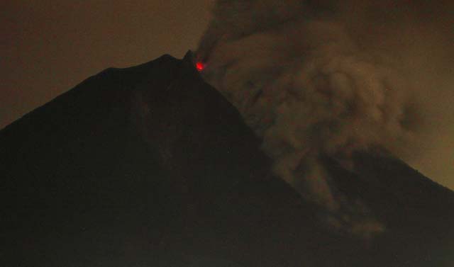 |
Figure 6. Sinabung erupts and emits a pyroclastic flow on 6 November 2013. Glowing material appears just below the summit. Hundreds of residents were evacuated to safer areas as the volcano erupted anew following the earlier September 2013 eruptions. Courtesy of Atar/AFP/Getty Images; appeared in Taylor (2013). |
The next day an ash plume rose to the same altitude but was not observed in satellite images because of meteorological cloud cover. Webcam images showed an eruption on 8 November that produced a low-level ash plume. The Jakarta Meteorological Watch Office, the webcam, and satellite data detecting SO2 indicated two explosions on 10 November. The first one, at 0720, generated an ash plume that rose to an altitude of 3.7 km. The altitude of the second plume, from an explosion at 1600, was unknown.
An ash plume on 11 November rose to an altitude of 3 km and drifted less than 20 km SW (figure 3). The next day an ash plume rose to an altitude of 3.7 km and drifted almost 40 km NW.
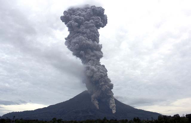 |
Figure 7. A press photo taken at Sinabung on 11 November 2013. A larger pyroclastic flow seems poised to descend from the summit area behind two smaller, adjacent pyroclastic flows. A narrow columnar cloud hangs over the summit. Courtesy of AP Photo/Dedy Zulkifli; appeared in Taylor (2013). |
Based on webcam data and satellite images, the Darwin VAAC reported that during 13-14 November an ash plume from Sinabung rose to an altitude of 3.7 km and drifted almost 150 km NW and W. A pyroclastic flow traveled 1.2 km down the SE flank on 14 November, prompting more evacuations from villages near the base of the volcano.
An explosion observed with the webcam on 18 November 2013 produced an ash plume that rose to an altitude of 7.6 km. About 30 minutes later an ash plume also visible in satellite images rose to an altitude of 11.3 km and drifted 65 km W. Four hours later satellite images showed fresh ash plumes at an altitude of 9.1 km to the W of Sinabung and at an altitude of 4.6 km over the crater. On 19 November the webcam recorded an ash plume that rose to an altitude of 4.6 km over the crater. A news article stated that later that night that an ash plume rose to an altitude of 10 km.
A news article from 20 November noted that volcanologists updated the previous hazard map for Sinabung (see figure in BGVN 35:07). The second-tier disaster-prone area, previously defined as a radius of 2-3 km from Sinabung's crater, was expanded to 4-5 km.
CVGHM reported three explosions from Sinabung on 17 November 2013. The first explosion, at 2024, generated an ash plume that rose 500 m and drifted SW, and a pyroclastic flow that traveled 500 m down the SE flank.
At 2152 hours that day a dense ash plume from an explosion rose 500 m and drifted SW. Incandescent material was ejected 50 m away from the crater. At 2252 an ash plume rose 1 km and drifted SW. At 0704 on 18 November an explosion generated an ash plume that rose 8 km and drifted SW. A pyroclastic flow also traveled 800 m down the SE flank.
On 19 November at 2155 a dense ash plume rose 10 km, drifted SW, and exhibited lightning. Pyroclastic flows again traveled 500 m SE. Multiple explosions on 20 November (at 0240, 0405, 0529, 0619, and 0641) generated ash plumes that rose to heights between 1 and 3.5 km. An explosion at 1716 was detected by the seismic network but cloud cover prevented observations of possible plumes. White plumes rose 100 m on 21 and 23 November, but misty conditions prevented visual observations on 22 November. On 23 November scoria fell in the Sigarang-garang and Desa Kuta villages in the NNE. Two explosions on 24 November, at 0043 and 0232 hours, were detected but not visually observed. Ash plumes rose 8 km and drifted NNE at 0727, rose 1 km at 0812, and rose 3 km at 0855. Since Sinabung's activity continued to increase, CVGHM raised the Alert Level to IV on 24 November. CVGHM noted that residents and tourists were advised not to approach the crater within a 5-km radius. Remaining residents in 17 villages around the volcano were to be evacuated.
News reported that on the morning of 25 November 2013 six new eruptive events sent "lava and searing gas" up to 1.5 km down the slopes, causing villagers to evacuate; this description apparently refers to pyroclastic flows. Volcanic material erupted as high as 2 km above the crater. The Indonesian National Agency for Disaster Management (BNPB) reported that 17,713 people, out of the 20,270 residents had been evacuated to 31 shelters.
Based on webcam data and wind data, the Darwin VAAC reported that during 28-31 November and 2 December ash plumes from Sinabung rose to altitudes of 3-5.5 km. Ash plumes drifted 150 km W during 30-31 November and 55 km W on 2 December. On 3 December ash plumes rose to an altitude of 8.2 km and drifted W. According to a news report on 2 December, landslides triggered by torrential rain buried houses and killed nine people in Gundaling village, 12 km E. On 4 December an ash plume from Sinabung rose to an altitude of 8.2 km and drifted N. Later that day and during 5-6 December ash plumes rose to altitudes of 3-3.7 km and drifted NW. CVGHM reported that observers in Ndokum Siroga, about 8.5 km away from the volcano, noted gray plumes rising 1 km above Sinabung on 6 December. They also saw grayish-white and dense white plumes as high as 400 m on 7 and 8 December, respectively. Dense grayish-to-white plumes rose 70-200 m on 9 December. White plumes rose 100-150 m above the crater during 10-13 December. Tremor during 6-13 December was recorded continuously, with varying amplitude. The number of low-frequency earthquakes significantly increased on 7 December, and the number of hybrid earthquakes increased the next day. RSAM (real-time seismic amplitude measurement) values of energy steadily increased since 28 November. The Alert Level remained at IV.
In conclusion, seismicity and images of ash plumes and pyroclastic flows suggest that the current eruption of Sinabung volcano began around 14-15 September 2013 and has continued through at least 11 December 2013.
Reference: Taylor, A., 18 November 2013, In Focus: The Eruptions of Mount Sinabung, The Atlantic (URL: http://www.theatlantic.com/infocus/2013/11/the-eruptions-of-mount-sinabung/100630/).
Geological Summary. Gunung Sinabung is a Pleistocene-to-Holocene stratovolcano with many lava flows on its flanks. The migration of summit vents along a N-S line gives the summit crater complex an elongated form. The youngest crater of this conical andesitic-to-dacitic edifice is at the southern end of the four overlapping summit craters. The youngest deposit is a SE-flank pyroclastic flow 14C dated by Hendrasto et al. (2012) at 740-880 CE. An unconfirmed eruption was noted in 1881, and solfataric activity was seen at the summit and upper flanks in 1912. No confirmed historical eruptions were recorded prior to explosive eruptions during August-September 2010 that produced ash plumes to 5 km above the summit.
Information Contacts: Center of Volcanology and Geological Hazard Mitigation (CVGHM) (also known as Pusat Vulkanologi dan Mitigasi Bencana Geologi-PVMBG), National Agency for Disaster Management (Badan Nacional Penanggulangan Bencana-BNPB), Jalan Diponegoro 57, Bandung 40122, Indonesia (URL: http://vsi.esdm.go.id/); Darwin Volcanic Ash Advisory Centre (VAAC), Bureau of Meteorology, Northern Territory Regional Office, PO Box 40050, Casuarina, NT 0811, Australia (URL: http://www.bom.gov.au/info/vaac/); CBC.CA News, Toronto, Canada (URL: http://www.cbc.ca/); The Atlantic (URL: http://www.theatlantic.com); ReliefWeb (a specialized digital service of the United Nations Office for the Coordination of Humanitarian Affairs-OCHA) (URL: reliefweb.int); and Volcano Discovery (URL: http://www.volcanodiscovery.com).