Report on Barren Island (India) — October 2013

Bulletin of the Global Volcanism Network, vol. 38, no. 10 (October 2013)
Managing Editor: Richard Wunderman.
Barren Island (India) Ash plume drifted up to 220 km SW in February 2013
Please cite this report as:
Global Volcanism Program, 2013. Report on Barren Island (India) (Wunderman, R., ed.). Bulletin of the Global Volcanism Network, 38:10. Smithsonian Institution. https://doi.org/10.5479/si.GVP.BGVN201310-260010
Barren Island
India
12.278°N, 93.858°E; summit elev. 354 m
All times are local (unless otherwise noted)
Our last Bulletin report (BGVN 36:06) noted that Barren Island was still erupting during 2011. This report both discusses an April 2010 ash plume that recently came to our attention and reports on activity as late as October 2013. A regional map appears in the last section.
On 19 April 2010, based on analysis of satellite imagery, the Darwin Volcanic Ash Advisory Centre (VAAC) reported that a plume from Barren Island rose to an altitude of 2.4 km and drifted 55 km N. Ash, however, could not be identified from the satellite data.
A Twitter posting included the photo in figure 20, an image apparently acquired in December 2010. The Indian Navy (via Twitter) reported seeing "smoke" and lava was also seen on the island from a surveillance plane on 16 October 2013. A large hot spot is visible on recent MODIS satellite data.
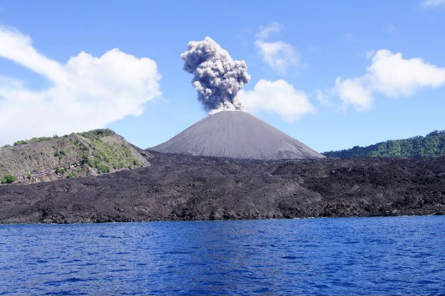 |
Figure 20. A photo of Barren Island emitting a dark ash plume from its main cone. The photo's metadata indicated that it was taken on 10 December 2010. Copyrighted photo by Paul Andrew Johnson and posted on Panoramio photo display website. |
VAAC reported that on 16 February 2013 during 1430 to 2000 (UTC date and time) an ash plume from Barren Island reached an altitude of 6.1 km and drifted 220 km SW. Meteorological clouds masked the ash cloud after 2000 UTC and the VAAC warned that ash could still reside at altitude. The 16 February 2013 plume height was derived from a 1530 UTC MTSAT-2 infrared image and an atmospheric sounding at Penang made at 1200 UTC. The VAAC also created a forecast of the plume's movement based on the Hysplit model data.
Darwin VAAC found that on 17 October 2013 an ash plume rose to an altitude of 3.7 km and drifted ~30 km NW. The plume was first seen in imagery at 0732 UTC and last seen at 0932 UTC. Plume height was derived from MTSAT-2 visible wavelength image, observed ash movement, and comparison to winds from both an atmospheric model and a 0600 UTC sounding.
Regional map. A regional map brings together geography and tectonics of the region centered on Barren Island (figure 21).
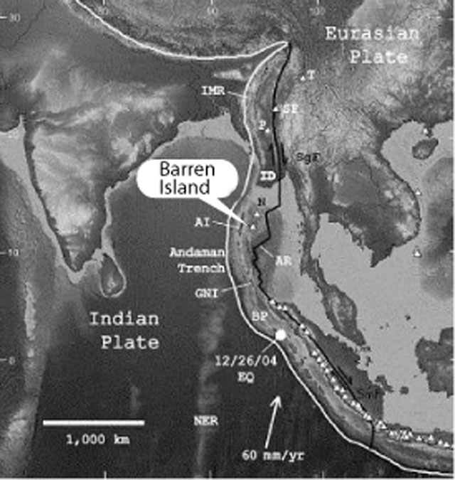 |
Figure 21. Location map for Barren Island seen on the digital version of the wall map "This Dynamic Planet" (Simkin and others, 2005). The background image is from ER Mapper. The oceanic bathymetry and on-land topography translate for this gray-scale image, forming two independent series ranging from dark (low) to light (high). Thus, deep ocean and low land are dark, and shallow ocean and high land are light. White triangles with black borders represent Holocene volcanoes (Siebert and Simkin, 2002). Labeled volcanoes are Barren Island, Narcondam (N); Popa (P) and the Singu Plateau (SP) in Myanmar, the Tengchong pyroclastic cones (T) in southern China. The curving white line is the convergent boundary between the Indian Plate and the Eurasian Plate, including the Burma sub-plate (BP) of the Eurasian Plate. |
At Barren Island's latitude, the convergent boundary is the subduction zone named the Andaman trench; to the S is the Sumatran trench, and to the N is the continental-collision zone marked by the Indo-Myanmar ranges (IMR) and still farther N and W, the Himalayan front. The large white arrow shows the NNE relative-motion vector of ~60 mm/yr for the Indian Plate and the Eurasian PlateW of Sumatra. The 26 December 2004 Sumatran earthquake (Mw 9.3) is marked by a white dot. Taken from Sanjeev Raghav (2011).
References: Luhr, J. F. and Haldar, D., 2006, Barren Island volcano (NE Indian Ocean): island-arc high-alumina basalts produced by troctolite contamination; J. Volcanol. Geotherm. Res., vol. 149, pp. 177-212.
Ray, J.S, Pande K., Awasthi, N. 2013, A minimum age for the active Barren Island volcano, Andaman Sea, Current Science; Special Section: Earth Sciences, Vol. 104, No. 7, 10 April 2013.
Sanjeev, R. 2011, Barren Volcano- A Pictorial Journey From Recorded Past To Observed Recent Part-I Earth Science India, Open Access e-Journal, Popular Issue, IV (III), July, 2011; (URL: www.earthscienceindia.info ).
Siebert, L. and Simkin, T.,2002, Volcanoes of the world: an illustrated catalog of Holocene volcanoes and their eruptions, Smithsonian Institution Global Volcanism Program, Digital Information Series, GVP-3.
Simkin, T., Tilling, R.I., Vogt, P.R., Kirby, S., Kimberly, P., and Stewart, D.B. This Dynamic Planet: World Map of Volcanoes, Earthquakes, Impact Craters, and Plate Tectonics U.S. Geological Survey (2005).
Geological Summary. Barren Island, a possession of India in the Andaman Sea about 135 km NE of Port Blair in the Andaman Islands, is the only historically active volcano along the N-S volcanic arc extending between Sumatra and Burma (Myanmar). It is the emergent summit of a volcano that rises from a depth of about 2250 m. The small, uninhabited 3-km-wide island contains a roughly 2-km-wide caldera with walls 250-350 m high. The caldera, which is open to the sea on the west, was created during a major explosive eruption in the late Pleistocene that produced pyroclastic-flow and -surge deposits. Historical eruptions have changed the morphology of the pyroclastic cone in the center of the caldera, and lava flows that fill much of the caldera floor have reached the sea along the western coast.
Information Contacts: Darwin Volcanic Ash Advisory Centre (VAAC), Bureau of Meteorology, Northern Territory Regional Office, PO Box 40050, Casuarina Northern Territory 0811 Australia; Twitter (URL: https://twitter.com/twitter); and VolcanoDiscovery (URL: http://www.volcanodiscovery.com/).