Report on Nishinoshima (Japan) — November 2013

Bulletin of the Global Volcanism Network, vol. 38, no. 11 (November 2013)
Managing Editor: Richard Wunderman.
Nishinoshima (Japan) November 2013 submarine flank eruption spurs island growth
Please cite this report as:
Global Volcanism Program, 2013. Report on Nishinoshima (Japan) (Wunderman, R., ed.). Bulletin of the Global Volcanism Network, 38:11. Smithsonian Institution. https://doi.org/10.5479/si.GVP.BGVN201311-284096
Nishinoshima
Japan
27.247°N, 140.874°E; summit elev. 100 m
All times are local (unless otherwise noted)
A new island emerged on 20 November 2013 out of the ocean as the result of a Surtseyan eruption on the S flank of Nishinoshima, a small volcanic island in the Izu-Bonin arc, ~940 km S of Tokyo (figure 1). The new island, originally called Niijima ('new island') by the Japan Coast Guard (JCG), eventually merged with Nishinoshima on 24 December 2013. We continue to describe the now merged islands under the name 'Nishinoshima.'
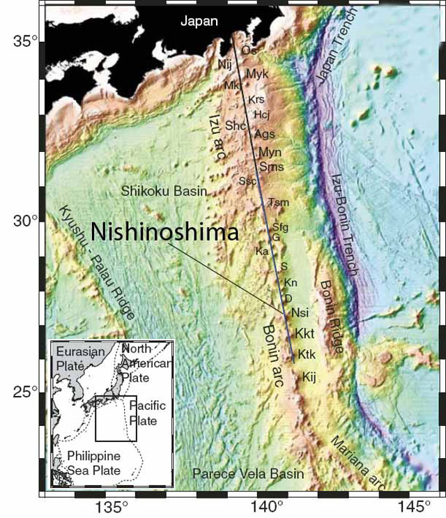 |
Figure 1. Location of Nishinoshima island shown on an annotated topographic map of the Izu-Bonin arc; the insert shows the area of the main map and the larger regional geography. The map highlights the location of Nishinoshima (Nsi). Other features located respectively from N to S are: Os–Oh–shima; Nij–Nii–jima; Myk–Miyake–jima; Mkr–Mikura–jima; Krs–Kurose hole; Hcj–Hachijo–jima; Shc–outh Hachijo caldera; Ags–Aoga–shima; Myn–Myojin knoll; Sms–South Sumisu; Ssc–South Sumisu caldera; Tsm–Torishima; Sfg–Sofugan; G–Getsuyo seamount; Ka–Kayo seamount; S–Suiyo seamount; Kn–Kinyo seamount; D–Doyo seamount; Nsi–Nishinoshima; Kkt–Kaikata seamount; Ktk–Kaitoku seamount; and Kij–Kita Iou-jima. After Kodaira and others (2007). |
Niijima emerges. Niijima emerged by 20 November 2013 from the ocean surface at an area ~0.5 km SSE off the coast of Nishinoshima. The latter is a small (700 m2), uninhabited volcanic island that last erupted and expanded in during 1973-74. Additional background information is included at the end of this report.
Based on satellite images, the Tokyo Volcanic Ash Advisory Center (VAAC) reported that at 0717 UTC on 20 November 2013 a plume rose 600 m over a new island which emerged ~500 m S of Nishinoshima (figure 2). At 0630 UTC on 22 November, a plume rose 900 m. MODVOLC satellite thermal alerts were measured almost daily from 1635 UTC on 23 November and continued through the latest alert noted at 0120 UTC on 7 April 2014.
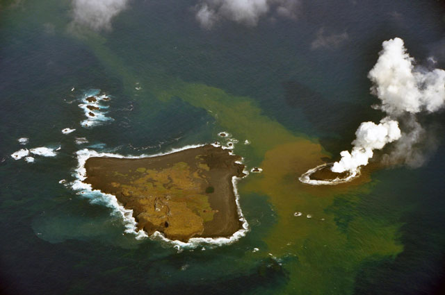 |
Figure 2. Niijima produces a plume as it emerges from the ocean to form a new island off the coast of Nishinoshima on 20 November 2013. Courtesy of Kurtenbach (2013); image from the JCG. |
On 21 November JCG and the Japan Meteorological Agency (JMA) noted that the island formed was by then ~200 m in diameter. A warning of dense black emissions from the eruption was issued by JCG on 20 November, and television footage (Frisk, 2013) showed on 21 November ash and rocks exploding from the crater as steam billowed out of the crater (figure 3). On 24 November, JCG reported lava flows coming from the newly-formed crater. They extended to the coastline of the island, and bombs continued to be ejected.
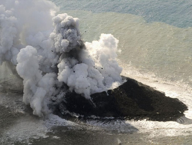 |
Figure 3. A photograph of Niijima from 21 November 2013 shortly after it emerged from the ocean. Note the large airborne rock erupting from the crater. Courtesy of Kurtenbach (2013); picture provided by JCG. |
The Advanced Land Imager (ALI) on NASA's Earth Observing-1 (EO-1) satellite captured a natural-color image on 8 December 2013 (figure 4). JMA reported that by early December the area of the new island had grown to 56,000 m2, about three times its initial size, and was 20 to 25 m above sea level.
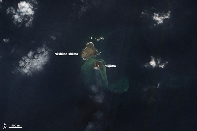 |
Figure 4. NASA Earth Observatory satellite image acquired on 8 December 2013 from the EO-1 ALI sensor. The discolored water around the island was attributed to material included volcanic minerals, gases, and seafloor sediment stirred up by the ongoing volcanic eruption. The faint white puffs above the center and SW portion of the island are likely steam and other volcanic gases associated with the eruption. Courtesy of NASA Earth Observatory. |
Niijima merges with Nishinoshima. NASA's EO-1 ALI satellite again captured a natural-color image of Nishinoshima and Niijima islands on 24 December 2013 and shows only a narrow channel of water appearing to separate the two (figure 5). The water around the islands continued to be discolored by volcanic minerals and gases, as well as by seafloor sediment stirred up by the ongoing eruption. A faint plume, likely steam and other volcanic gases associated with the eruption, drifted SE. Infrared imagery from the same satellite on the same date showed intense heat from the fresh lava, which continued to build the new island. A strip of isolated, discolored (orange) seawater appeared at the junction of the two islands (figure 6).
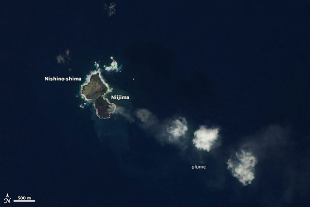 |
Figure 5. NASA Earth Observatory satellite image acquired 24 December 2013. Courtesy of NASA Earth Observatory; satellite image by Jesse Allen using EO-1 ALI data from the NASA EO-1 team. |
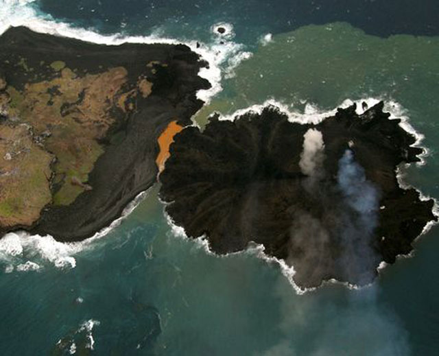 |
Figure 6. An aerial photograph just prior to the merger of the two islands, taken on 24 December 2013, with Niijima on the right and Nishinoshima on the left. Seawater trapped at the junction has been discolored to orange, attributed to the presence of particulate matter and biochemical activity of organisms in the water. Courtesy of the JCG. |
Figure 7 is a drawing by the Japanese Coast Guard (JCG) showing the location of the coastline and the growth of the new island (Niijima) from 20 November 2013 to 26 December 2013. It is striking how much of the island expanded during 13-24 December 2013.
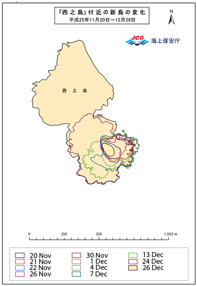 |
Figure 7. Scale drawing of the merged islands showing the changing coastlines as the new island grew. Colored enclosing lines during the current eruption of Nishinoshima as shown for the following dates: 20, 21, 22, 26, and 30 November 2013, and 1, 4, 7, 13, 24, and 26 December 2013 (note legend translated from Japanese for dates and color of mapped shorelines). Image and interpretation courtesy of JCG. |
According to JCG's aerial observation on 20 January 2014, the new part of Nishinoshima island had an area of 0.3 km2 (750 m E to W, and 600 m N to S) (figure 8).
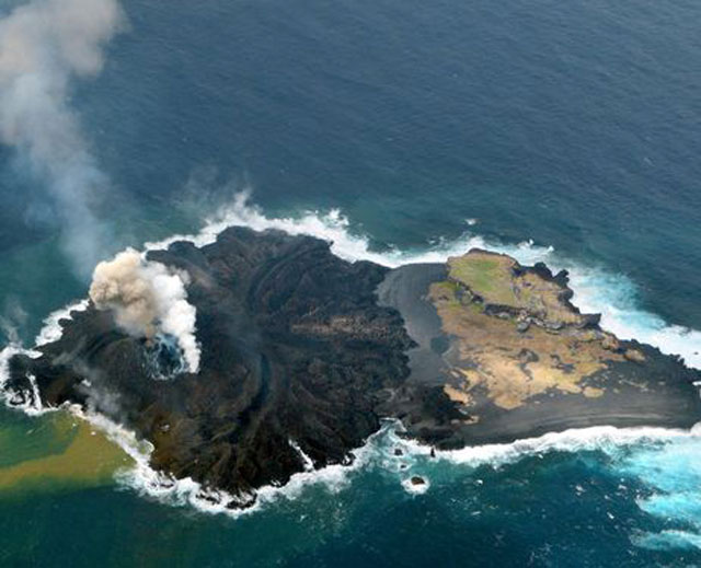 |
Figure 8. An aerial photograph, looking W, of Nishinoshima island taken on 20 January 2014. The newly merged island, Niijima, on the left, continued to expand NW. White and brown plumes rose from vents on the new land, and the water around the SW portion was discolored. Photo courtesy of JCG. |
New images from an overflight on 3 February (figure 9) confirmed that the activity on the former new island continued steadily. Over the past weeks, the vent fed several active lava flow fronts that enlarged the land in more or less all directions. In particular, there are two active flows relatively close to the vent which had been traveling E and formed a small, almost closed bay with green-orange discolored water inside. The previous shorelines for 20 January 2014 (yellow enclosing line) and 21 November 2013 (white enclosing line) are superimposed over the image to show the growth of the island.
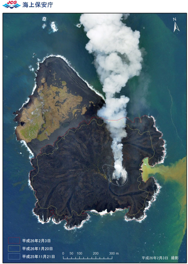 |
Figure 9. Aerial photography of the island on 3 February 2014. For comparison, the previous shorelines on 20 January 2014 (yellow enclosing line) and 21 November 2013 (white enclosing line). Photo courtesy of JCG. |
According to Pfeiffer (2014), the island continued growing with lava flows traveling in several directions (figure 10). Its highest peak, formed by the most western of the two active vents, was measured at 66 m. The new addition has more than doubled the size of the island by 16 February. A black-sand beach formed on the NE shore of the old part of the island, as a result of lava fragments washed up by currents and waves.
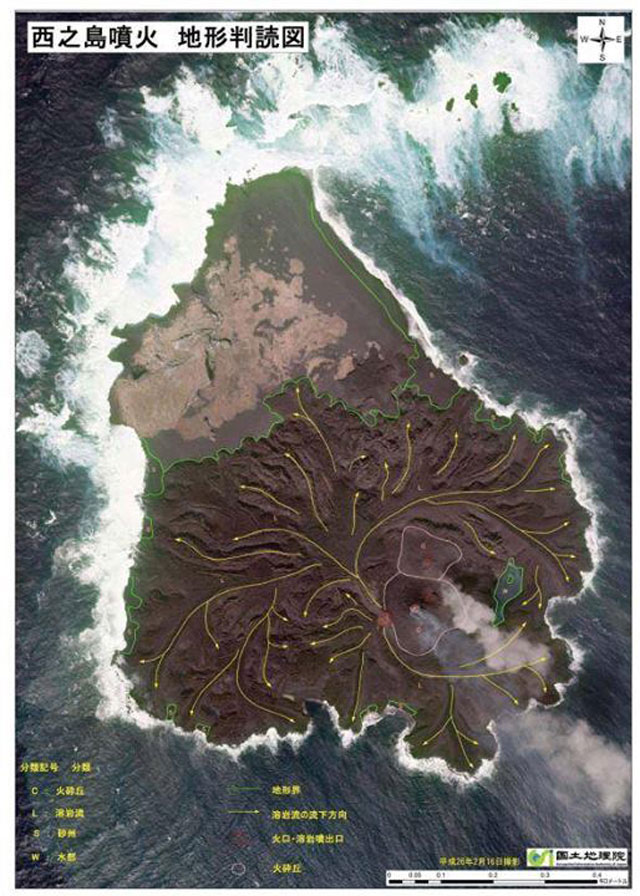 |
Figure 10. Direction of lava flow from the western side of two active vents is show by vectors superimposed on the image of the island. North is to the top of the photo. The flow arrows were drawn by JCG over an aerial photograph of the island taken 16 February 2014. Photo courtesy of JCG. |
In summary, the new addition to Nishinoshima grew ~500 m SSE of the island's S flank, beginning ~20 November 2013, from a depth of ~50 m to a height of ~65 m from an originating time no earlier than 1974, the time of the latest addition to the island. Based on continued emissions and satellite-based thermal alerts, it is apparent as of 13 March 2014 that Niijima was still expanding outward in all directions from the vents, and that Nishinoshima had grown to over three times its original size.
Further background. The new island was located in the Volcano Islands, a group of three Japanese active volcanic islands that lie atop the Izo-Bonin-Mariana arc system (Stern and Bloomer, 1992) that stretches S of Japan and N of the Marianas (figure 1).
According to the Geological Survey of Japan, Nishinoshima was an emerged submarine volcano in 1974 with a height of ~3,000 m from the surrounding ocean floor and ~30 km wide at its base.
For further details on earlier Nishinoshima activity refer to our earlier reports in predecessor publications, CSLP 93-73 (eight cards issued during 1973-1974), SEAN 04:07, and BVE 25. The latter (BVE 25) is a 1985 Smithsonian report called the Bulletin of Volcanic Eruptions noting that aerial observations on 2 December 1985 disclosed pale green water SW from the island.
The Geological Survey of Japan reported that Nishinoshima is of andesite to basaltic-andesite composition; Aoki and others (1983) classified the volcano's rocks as high-alkali tholeiite. Nishinoshima is surrounded on all sides by cones, vents, pillars, and parasitic seamounts, and its local bathymetry from surveys in 1911 and 1992 are shown in figure 11.
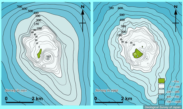 |
Figure 11. Comparison of bathymetric maps (depths in meters) around Nishinoshima before and after 1973 eruption. The emerged island is shown in green. Depths of 0-100 m are in white, 100-400 m in light blue, 400-700 m in medium blue, and 700-1,000 m in darker blue. The map on the right shows a survey conducted in 1992, after the eruption, based on 1:50,000 basic map of "Nishino-shima" by the Japan Coast Guard (1993). The map on the left shows a survey conducted prior to the eruption, based on mapping in 1911 (Ossaka, 1973). The new island of Niijima first appeared above the sea surface ~500 m SSE of the S coast of Nishinoshima island shown in the 1992 map. Courtesy of the Geological Survey of Japan (2013). |
From the 1992 bathymetric map seen at right on figure 11, it is apparent that the ocean depth from which Niijima erupted in 2013, was ~50 m. A sketch of the setting showing a cross sectional view (roughly NNW-SSE) appears in figure 12.
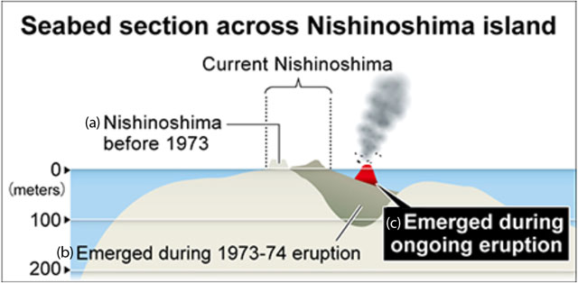 |
Figure 12. A sketch depicting an approximately NNW (to the left) to SSE (to the right) cross-section across Nishinoshima (blue indicates sea water) portraying some historical stages of growth. The label "Current Nishinoshima" refers to the pre-existing island prior to and in the early stages of the 2013 eruption. Other labels indicate (a) "Nishinoshima before 1973" (also see 1911 bathymetric map in figure 11), (b) flanking material added to Nishinoshima as it "Emerged during the 1973-74 eruption" (also see 1992 bathymetric map in figure 11), and (c) Niijima "Emerging during ongoing eruption" (red area emerging from the sea early in the 2013 eruption). Original drawing courtesy of The Asahi Shimbun (2013). |
References. Aoki, H., and Tokai University Research Group for Marine Volcano, 1983, Petrochemistry of the Nishinoshima Islands, La mer, v. 22, pp. 248-256.
Earth of Fire: Actualité volcanique, Article de fond sur étude de volcan, tectonique, récits et photos de voyage [Volcano News, Feature Article on study of volcanos, tectonics, travel stories and photos], 2013, Evolution of Nishino-shima's eruption, Earth-of-Fire web site (URL: http://www.earth-of-fire.com/page-8837676.html).
Frisk, A., 2013 (21 November), WATCH: Incredible video, photos show new island forming off Japan after volcanic eruption, Global News (URL: http://globalnews.ca/news/981245/watch-incredible-video-photos-show-new-island-forming-off-japan-after-volcanic-eruption/ ).
Geological Survey of Japan, 2013, Nishinoshima (URL: https://gbank.gsj.jp/volcano/Quat_Vol/volcano_data/G22.html).
Japan Coast Guard, 1993, 1:50,000 basic map of "Nishino-shima."
Kodaira, S., Sato, T., Takahashi, N., Miura, S., Tamura, Y., Tatsumi, Y., and Kaneda, Y., 2007, New seismological constraints on growth of continental crust in the Izu-Bonin intra-oceanic arc, Geology, v. 35, no. 11, pp. 1031-1034 (doi: 10.1130/G23901A.1).
Kurtenbach, E., 2013 (21 November), Volcano raises new island far south of Japan, AP (Associated Press) (URL: http://news.yahoo.com/volcano-raises-island-far-south-japan-054228644.html).
Ossaka, J., 1973, On the submarine eruption of Nishinoshima, Bulletin of the Volcanological Society of Japan, v. 18, no. 2, p. 97-98, 173-174.
Pfeiffer, T., 2014 (21 February), Nishinoshima volcano (Izu Islands, Japan): island has doubled in elevation, Volcano Discovery web site (URL: http://www.volcanodiscovery.com/nishino-shima/news/42781/Nishino-Shima-volcano-Izu-Islands-Japan-island-has-doubled-in-elevation.html).
Shun, N., 2014, Kaitei chikei (bottom topography), Nishinoshima Kazan (in Japanese), Geological Survey of Japan web site (URL: https://gbank.gsj.jp/volcano/Act_Vol/nishinoshima/page3.html).
The Asahi Shimbun, 2013 (22 November), Japan counts on survival of new island to expand territorial waters (URL: https://ajw.asahi.com/article/behind_news/social_affairs/AJ201311220084).
Geological Summary. The small island of Nishinoshima was enlarged when several new islands coalesced during an eruption in 1973-74. Multiple eruptions that began in 2013 completely covered the previous exposed surface and continued to enlarge the island. The island is the summit of a massive submarine volcano that has prominent peaks to the S, W, and NE. The summit of the southern cone rises to within 214 m of the ocean surface 9 km SSE.
Information Contacts: Japan Coast Guard (JCG) (URL: http://www.kaiho.mlit.go.jp/); MODVOLC, Hawai'i Institute of Geophysics and Planetology (HIGP), MODVOLC Thermal Alerts System, School of Ocean and Earth Science and Technology (SOEST), Univ. of Hawai'i, 2525 Correa Road, Honolulu, HI 96822, USA (URL: http://modis.higp.hawaii.edu/); NASA Earth Observatory (URL: http://earthobservatory.nasa.gov); ANN (All Nippon News Network) (URL: https://www.youtube.com/user/ANNnewsCH); VolcanoCafe web site (URL: http://volcanocafe.wordpress.com); Earth of Fire web site (URL: http://www.earth-of-fire.com/); Demis web site (URL: http://www.demis.nl/home/pages/Gallery/examples.htm.).