Report on Sangeang Api (Indonesia) — February 2014

Bulletin of the Global Volcanism Network, vol. 39, no. 2 (February 2014)
Managing Editor: Richard Wunderman.
Sangeang Api (Indonesia) Ashfall from 30 May 2014 eruption causes evacuations, airline delays
Please cite this report as:
Global Volcanism Program, 2014. Report on Sangeang Api (Indonesia) (Wunderman, R., ed.). Bulletin of the Global Volcanism Network, 39:2. Smithsonian Institution. https://doi.org/10.5479/si.GVP.BGVN201402-264050
Sangeang Api
Indonesia
8.2°S, 119.07°E; summit elev. 1912 m
All times are local (unless otherwise noted)
Due to elevated seismic activity, the Indonesian Center for Volcanology and Geologic Hazard Mitigation (CVGHM) issued an alert for Sangeang Api volcano on 21 May 2014. On 30 May 2014 at 1555, CVGHM reported an eruption of the island volcano that generated an explosive eruption column of ash and sulfur dioxide into the atmosphere, extending >3 km above the summit (figure 8). While the 13-km-wide island of Sangeang has no permanent settlements or residents, dozens of farmers cultivate land on the island during the growing and harvest seasons. Photographs of the eruption showed several pyroclastic flows coming down the volcano summit to the S and E that may be hazardous to anyone of the island. On 30 May, the Alert Level was raised from 2 to 3 (on a scale of 1-4). Civil authorities evacuated 135 people from within 1.5 km of the volcano to the mainland (nearby Sumbawa Island), with the result that no one was reported to have been killed or injured during the eruption.
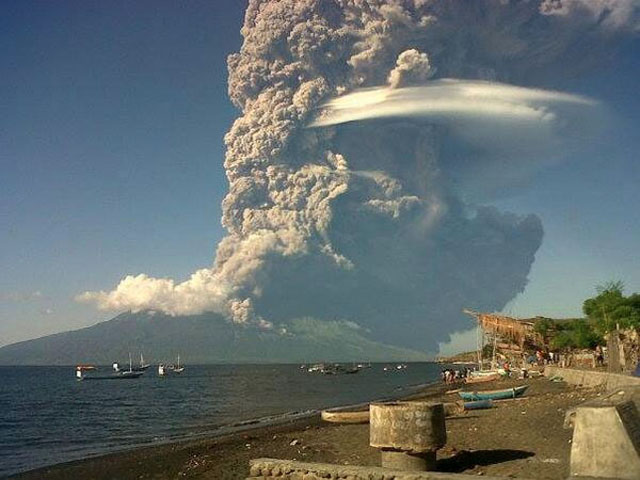 |
Figure 8. Eruption plume rising from Sangeang Api volcano on 30 May 2014, photographed to the N from Sambawa Island. Note the distinctive lenticular white cloud condensed from uplifted moist air carried by the rising plume. Pyroclastic flows can also be seen moving down along the S and E sides of the volcano. Courtesy of Anonymous (2014). |
Based on satellite images, pilot observations, and the Indonesian Meteorological Office, the Darwin VAAC reported that on 30 May an ash plume rose to an maximum altitude of 15.2 km and drifted 440 km E and 750 km SE (figure 9).
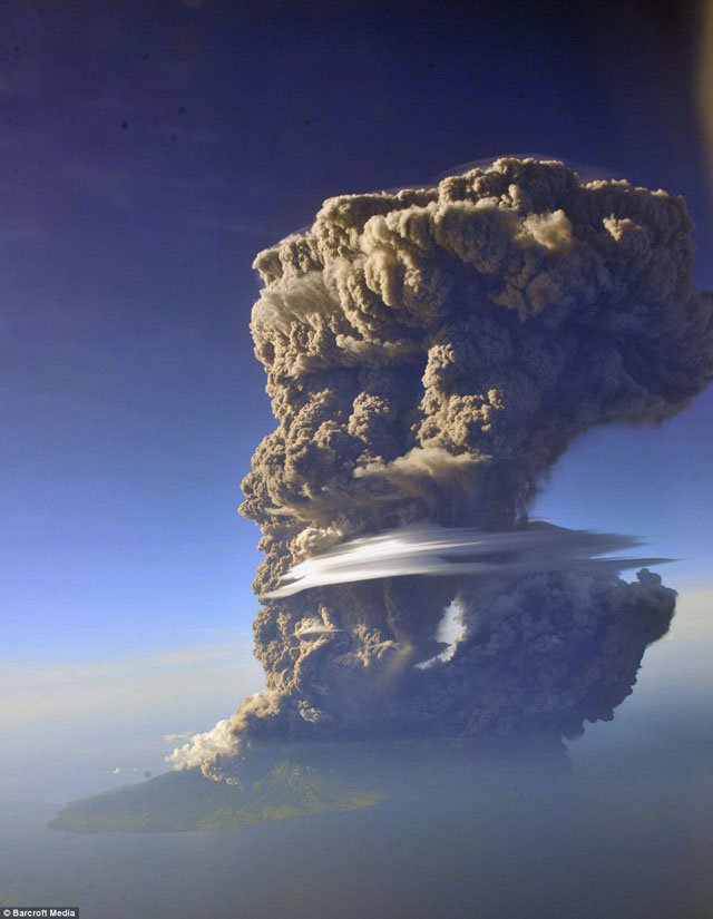 |
Figure 9. After erupting, the Sangeang Api volcano sent an ash plume to the E, along with a distinctive lenticular white cloud condensed from uplifted moist air. Pilots in the area reported seeing the cloud rising to 19.8 km, spreading over a 40 km area. Photograph taken on 30 May 2014 by Sofyan Efendi looking N during a commercial flight from Bali to the fishing town of Labuan Bajo; from Hall (2014). |
The Indonesian Regional Disaster Management Agency (BNPB) reported that on 31 May two larger explosions occurred at 1330 and 2242 hrs. According to the VAAC, ash plumes from these two explosions rose to altitudes of 13.7-15.2 km and drifted 280 km NW (and other various directions, including S). Later in the day the ash plumes, including one from the previous day, eventually became detached. Ashfall affected many areas in the Bima Regency on the mainland, including Wera, and prompted the evacuation of 7,328 people from four villages within a radius of 8 km from Sangeang Api. The Bima and Tambolaka airports were temporarily closed. According to a news article, all flights to and from the Darwin International Airport in Australia on 31 May were canceled (figure 10). The VAAC noted that ash plumes rose to an altitude of 4.3 km on 1 June and drifted W and SW (figure 11). During 2-3 June ash plumes rose to altitudes of 3-4.3 km and drifted 45 km W. Based on analyses of satellite imagery and wind data, the Darwin VAAC reported that on 14 June an ash plume from Sangeang Api rose to an altitude of 2.1 km and drifted 55 km NW.
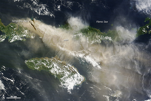 |
Figure 10. The Moderate Resolution Imaging Spectroradiometer (MODIS) aboard the Terra satellite captured imagery of the eruption plume from Sangeang Api (dark brown line on the image extending from the volcanic island to the SE) at 0235 UTC (1035 local time) on 31 May 2014. Ash drifted SE, shutting down airports in Bima, Indonesia, and Darwin, Australia. Service to Darwin resumed by 1 June, but Bima remained shut down as of 2 June, according to the Jakarta Globe. Other satellites have observed the ash plume as well. A near real-time tool developed by University of Wisconsin and NOAA scientists estimated that the plume reached an altitude of at least 12 to 14 km based on observations from multiple weather satellites. The Ozone Mapping & Profiler Suite on Suomi NPP also observed ash drifting toward Australia on 31 May. NASA image courtesy Jeff Schmaltz LANCE/EOSDIS MODIS Rapid Response Team, GSFC; Caption by Adam Voiland. From NASA Earth Observatory (2014, 3 June). |
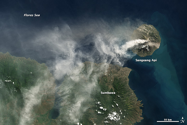 |
Figure 11. Landsat 8 satellite collected this true-color image of an ash plume rising from the Sangeang Api, an island volcano just of the coast of Sumbawa Island, Indonesia, on 1 June 2014. Note that on this day the plume is being blown W and then SW as compared with the previous day shown in figure 8. NASA Earth Observatory images by Robert Simmon, using Landsat 8 data from the USGS Earth Explorer. From NASA Earth Observatory (2014, 1 June). |
During the period from 2-17 June, thin to thick white smoke was ejected as high as 200-500 m. Seismic activity during the major part of the eruption is shown on Table 4; as of 17 June, seismicity continued to decline. The Alert Level was reduced from 3 to 2 (on a scale of 1-4) on 17 June.
Table 4. Numbers of daily earthquakes measured for 3 days during and after the eruption of Sangeang Api, as reported by CVGHM. 'VB' represents shallow volcanic earthquakes; 'VA' represents deep volcanic earthquakes; 'TL' represents local earthquake tectonics; 'X' indicates activity present; 'nr' is not reported .
| Date, 2014 | 30 May | 31 May | 1 June |
| VB | 88 | 143 | 35 |
| VA | 270 | 157 | 62 |
| TL | nr | nr | 5 |
| Volcanic swarm | X | nr | nr |
| Continuous tremor | X | X | X |
| Tremor eruption | X | X | X |
| Blowing earthquake | nr | nr | 36 |
MODVOLC and other satellite imaging. Satellite infrared measurements of thermal alerts over this Sangeang Api volcano eruption first appeared as 2 pixels (an area of thermal anomaly of ≥2 km2) at 1405 UTC on 30 May 2014. These were the first thermal alerts measured over Sangeang Api since 20 October 2013. From 30 May 2014 through 7 July, satellite crossings measured alerts of between 1 and 9 pixels (areas of ≥1 to ≥9 km2, respectively) daily until 1500 UTC on 30 June; the 9-pixel thermal alert was measured 20 June 2014 at 1425 UTC (figure 12). (Note: As an explanation for this technique, the MODVOLC web site states that "Using infrared satellite data provided by the Moderate Resolution Imaging Spectroradiometer (MODIS), scientists at the Hawai'i Institute of Geophysics and Planetology, University of Hawai'i, have developed an automated system [MODVOLC] which maps the global distribution of thermal hot-spots in near-real-time, and displays the results on this web-site." A paper by Wright and others (2004) states that "Although MODIS pixels are nominally 1 km, pixel size increases with distance from nadir and at the edges of the MODIS swath (where the scan angle reaches ±55°) MODIS pixels measure ~2.08 km in the along-track, and ~4.83 km in the across-track direction.")
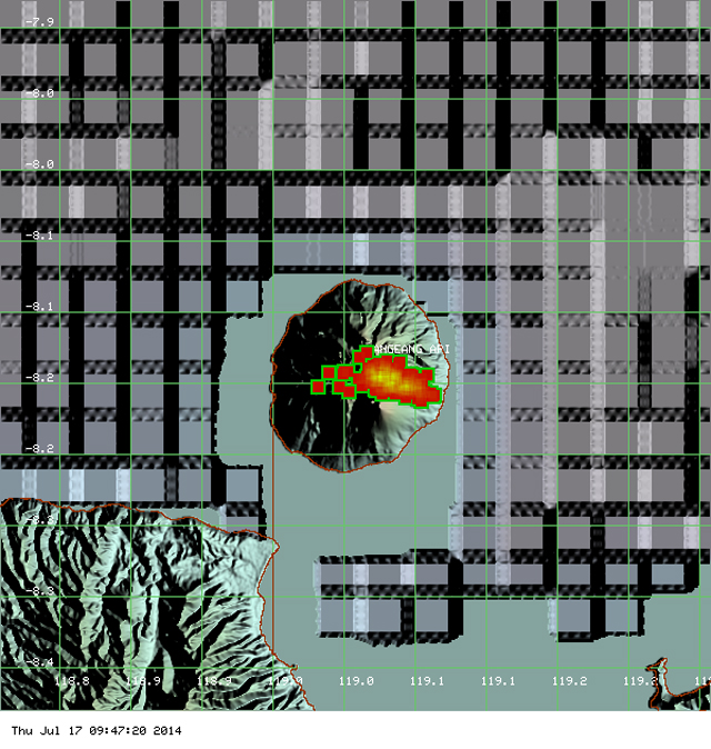 |
Figure 12. MODVOLC image for the period 30 May to 7 July 2014 of thermal alerts measured on Sangeang Api volcano. The volcano lies on the island of Sangeang just off the Indonesian island of Sumbawa. The central array of pixels trending E-W are for those alerts measured for the period 30 May - 30 June 2014. Courtesy of MODVOLC. |
Figures 13 and 14 show satellite images of ash plume temperature and SO2 plume from Sangeang Api volcano on 30 and 31 May 2014, respectively. The plume is obviously drifting to the E and S toward Australia.
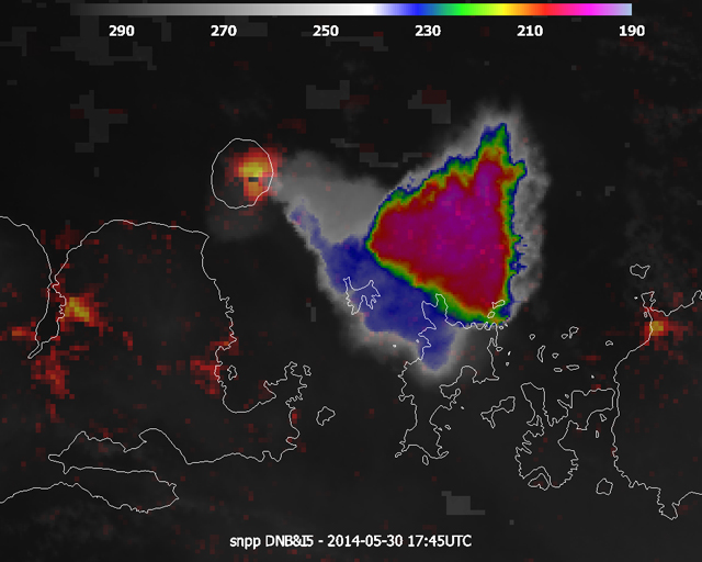 |
Figure 13. Composite of the Day-Night Band (DNB, red-to-yellow) at 750m resolution and the IR11.45 (I5, color scale at the top) channel at 375m resolution, image made 30 May 2014 at 1745 UTC. The DNB shows two craters at Sangeang Api volcano, Doro Api and Doro Mantoi. The brighter one was emanating the big plume with temperature values down to -196.5 K (76.6 °C) at the top. The secondary crater was emanating some material, but at much lower level so could hardly be seen. Courtesy of EUMETSAT (2014). |
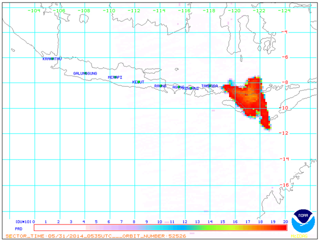 |
Figure 14. SO2 measured from the Sangeang Api volcano plume on 31 May 2014 at 0535 UTC. The volcano is located at the W end of the measured area. Courtesy of NOAA. |
References. Anonymous, 2014 (30 May), Massive volcano eruption: Sangeang Api volcano - Sunda Islands, Indonesia, Before Its News web site (http://beforeitsnews.com/environment/2014/05/massive-volcano-eruption-sangeang-api-volcano-sunda-islands-indonesia-2502094.html).
EUMETSAT, 2014, Eruption of Sangeang Api volcano: There were a series of spectacular eruptions from the Indonesian volcano Sangeang Api at the end of the May. URL: http://www.eumetsat.int/website/home/Images/ImageLibrary/DAT_2235292.html
NASA Earth Observatory, 2014 (3 June), Sangeang Api Erupts (URL: http://earthobservatory.nasa.gov/IOTD/view.php?id=83799).
NASA Earth Observatory, 2014 (1 June), Sangeang Api Eruption (URL: http://earthobservatory.nasa.gov/NaturalHazards/view.php?id=83887&eocn=image&eoci=nh_viewall)
Wright, R., Flynn, L.P, Garbeil, H., Harris, A.J.L., and Pilger, E., 2004, MODVOLC: near-real-time thermal monitoring of global volcanism, Journal of Volcanology and Geothermal Research, v. 135, pp. 29-49.
Hall, J., 2014 (30 May), Pictured from a passenger plane: Menacing 12-mile-high ash cloud looms over Indonesia's 'Mountain of Spirits' after volcano erupts, Daily Mail (URL: http://www.dailymail.co.uk/news/article-2644253/Incredible-moment-huge-volcano-erupts-Indonesia-sending-ash-spewing-thousands-feet-sky.html).
Geological Summary. Sangeang Api volcano, one of the most active in the Lesser Sunda Islands, forms a small 13-km-wide island off the NE coast of Sumbawa Island. Two large trachybasaltic-to-tranchyandesitic volcanic cones, Doro Api and Doro Mantoi, were constructed in the center and on the eastern rim, respectively, of an older, largely obscured caldera. Flank vents occur on the south side of Doro Mantoi and near the northern coast. Intermittent eruptions have been recorded since 1512, most of them during in the 20th century.
Information Contacts: Indonesian Centre for Volcanology and Geological Hazard Mitigation – CVGHM (also known as Pusat Vulkanologi dan Mitigasi Bencana Geologi - PVMBG)), Jalan Diponegoro 57, Bandung 40122, Indonesia (URL: http://www.vsi.esdm.go.id/); MODVOLC, Hawai'i Institute of Geophysics and Planetology (HIGP) Thermal Alerts System, School of Ocean and Earth Science and Technology (SOEST), Univ. of Hawai'i, 2525 Correa Road, Honolulu, HI 96822, USA (URL: http://modis.higp.hawaii.edu/); DARWIN VAAC (Darwin Volcanic Ash Advisory Centre), Bureau of Meteorology, Northern Territory Regional Office, PO Box 40050, Casuarina, NT 0811, Australia (URL: http://www.bom.gov.au/info/vaac/); Badan Penanggulangan Bencana Daerah (BPBD), Indonesian Regional Disaster Management Agency (URL: http://bpbd.malangkab.go.id/); and Badan Nasional Penanggulangan Bencana (BNPB), Indonesian National Disaster Management Agency (URL: http://www.bnpb.go.id/).