Report on Tinakula (Solomon Islands) — April 2014
Bulletin of the Global Volcanism Network, vol. 39, no. 4 (April 2014)
Managing Editor: Richard Wunderman.
Tinakula (Solomon Islands) Abnormal rumbling after M 7.9 earthquake of 6 February 2013
Please cite this report as:
Global Volcanism Program, 2014. Report on Tinakula (Solomon Islands) (Wunderman, R., ed.). Bulletin of the Global Volcanism Network, 39:4. Smithsonian Institution. https://doi.org/10.5479/si.GVP.BGVN201404-256010
Tinakula
Solomon Islands
10.386°S, 165.804°E; summit elev. 796 m
All times are local (unless otherwise noted)
Since the previous Bulletin report, which noted rumblings heard from the direction of the crater and small explosions emitting molten boulders (BGVN 37:06), there have been no further clear reports of eruptions that have come to our attention. A tectonic earthquake in February 2013 was accompanied by a cluster of foreshocks, a mainshock of magnitude M 7.9, followed by aftershocks. It took at least 10 lives. Around the time of the earthquake, 6 February, villagers on a neighboring island noted unusual activity, possibly associated with outgassing or a brief eruption at uninhabited Tinakula.
Anomalous volcano behavior. On 8 February, villagers of the island of Santa Cruz, among the closest inhabitants to Tinakula, reported having heard abnormal noises and rumblings coming from the volcano during the previous two days. First-hand reports also noted additional anomalies, including thin cloud cover around Tinakula's summit. The details remained equivocal and there were no similar announcements of uncharacteristic behavior during this reporting interval.
The Wellington Volcanic Ash Advisory Centre (VAAC) reported that the significant seismic activity led them to undertake an interval of heightened monitoring for both the volcanoes Traitor's Head in Vanuatu and Tinakula in the Solomon Islands (ICAO, 2014). Moreover, owing to the minor eruption of the volcano Gaua on the island of Vanuatu in April 2013, a Volcanic Ash Advisory was issued for the greater surrounding area, including the Tinakula region. The VAAC continued heightened monitoring through August 2013 due to the ongoing minor seismic activity and minor volcanic eruptions on White Island of New Zealand.
The following passages shift our discussion from the volcano to the regional geography and to events associated with the M 7.9 earthquake and tsunamis.
M 7.9 earthquake. The M 7.9 earthquake on 6 February 2013 occurred ~100 km SW of Tinakula (at 10.38°S, 165.8 °E), generating tsunamis at numerous monitoring locations (figure 16). As noted below, one aftershock, M 7, struck ~9 km from Tinakula but no damage was reported on the uninhabited island.
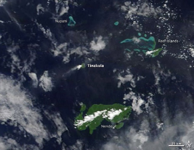 |
Figure 16. The relative positions of uninhabited Tinakula and inhabited Santa Cruz (Nendo) Island. Areas of denser white clouds over and downwind of topographic highs are probably attributable to meteorological phenomena, rather than eruptions or outgassing. The 6 February 2013 M 7.9 earthquake struck ~100 km SW of Tinakula. An aftershock struck ~9 km from Tinakula. Tsunamis ravaged coastal settlements on Santa Cruz (Nendo) Island. Courtesy of NASA Earth Observatory. |
In the days preceding the 6 February event, more than 40 small earthquake events of M 4.5 or higher occurred within 80 km of the M 7.9 earthquake. The National Oceanographic and Atmospheric Administration (NOAA) noted that more than 12 of these were M 5-6; an additional 7 events were greater than M 6. The majority of the seismic activity had epicenters between 40 km SE and 68 km SW of Tinakula with focal depths of 10 to 46 km.
Strong aftershocks continued through 8 February 2013. The largest aftershocks in this recording period occurred on 8 February. One, M 7.0, had its epicenter 65 km SE of Tinakula. A second, M 7.0, at 10 km focal depth, had its epicenter only 9 km SSW of Tinakula.
Over the course of 6-8 February there were over 100 tsunami run- ups, with typical displacements of 1-2 m. The events spurred circum-Pacific tsunami warnings and collectively took 10-11 lives near the epicenter on islands such as Santa Cruz (Nendo), Tomotu Noi, and Lata. Damage included the destruction or serious damage to 743 houses, as well as a dock at Lata island.
The region is regularly rocked by large earthquakes and was struck on 28 October 2013 by one of M 7.7. No abnormal activity from the volcano was noted.
Reference. ICAO (International Civil Aviation Organization), (17-20 February) 2014, International Airways Volcano Watch Operations Group (IAVWOPSG); 8th Meeting, Melbourne, Australia, 17 to 20 February 2014, ICAO (URL: http://www.icao.int/safety/meteorology/iavwopsg/IAVWOPSG Meetings Metadata/IAVWOPSG.8.WP.024.5.en.pdf ).
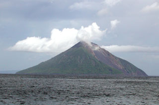
Geological Summary. The small 3.5-km-wide island of Tinakula is the exposed summit of a massive stratovolcano at the NW end of the Santa Cruz islands. It has a breached summit crater that extends from the summit to below sea level. Landslides enlarged this scarp in 1965, creating an embayment on the NW coast. The Mendana cone is located on the SE side. The dominantly andesitic volcano has frequently been observed in eruption since the era of Spanish exploration began in 1595. In about 1840, an explosive eruption apparently produced pyroclastic flows that swept all sides of the island, killing its inhabitants. Recorded eruptions have frequently originated from a cone constructed within the large breached crater. These have left the upper flanks and the steep apron of lava flows and volcaniclastic debris within the breach unvegetated.
Information Contacts: NOAA (URL: http://www.noaa.gov/); and Wellington Volcanic Ash Advisory Centre (VAAC) (URL: http://vaac.metservice.com/).