Report on Fuego (Guatemala) — April 2014

Bulletin of the Global Volcanism Network, vol. 39, no. 4 (April 2014)
Managing Editor: Richard Wunderman.
Edited by Julie A. Herrick.
Fuego (Guatemala) Explosions, ash plumes, lava flows, and lahars during April 2013-June 2014
Please cite this report as:
Global Volcanism Program, 2014. Report on Fuego (Guatemala) (Herrick, J.A., and Wunderman, R., eds.). Bulletin of the Global Volcanism Network, 39:4. Smithsonian Institution. https://doi.org/10.5479/si.GVP.BGVN201404-342090
Fuego
Guatemala
14.4748°N, 90.8806°W; summit elev. 3799 m
All times are local (unless otherwise noted)
In this report we highlight Fuego's ongoing eruptive activity during April 2013-June 2014. During this reporting period continued monitoring by the Instituto Nacional de Sismologia, Vulcanología, Meteorología e Hidrologia (INSIVUMEH) included ground-based observations, field visits, and seismic monitoring. Aviation reports were abundant from the Washington Volcanic Ash Advisory Center (VAAC). The active summit crater was a frequent source of thermal alerts from the MODVOLC system which is based on infrared radiation detected in space by the MODIS instruments.
Advancing lava flows and ash explosions. INSIVUMEH reported that lava flows advanced from Fuego's summit during the entire reporting interval. By 29 June 2014, a lava flow was extending 150 m toward the TaniluyÁ drainage and generating avalanches that reached the Ceniza drainage. Earlier in the year, lava flows up to 550 m long reached vegetated areas on the SW flank.
INSIVUMEH and Washington VAAC reported frequent ash explosions from Fuego's summit crater during April 2013-June 2014 (figure 28). Ash plumes typically rose 100-800 m above the summit. Significant ash plumes drifted 10-20 km from the summit in the direction of prevailing winds. An exceptional case occurred when ash drifted 30 km NW during activity on 30 December 2013. Constant fumarolic activity generated diffuse, white plumes that rose approximately 150 m above the summit. Incandescent explosions were also frequently observed at night and reached 200 m above the summit (figure 29).
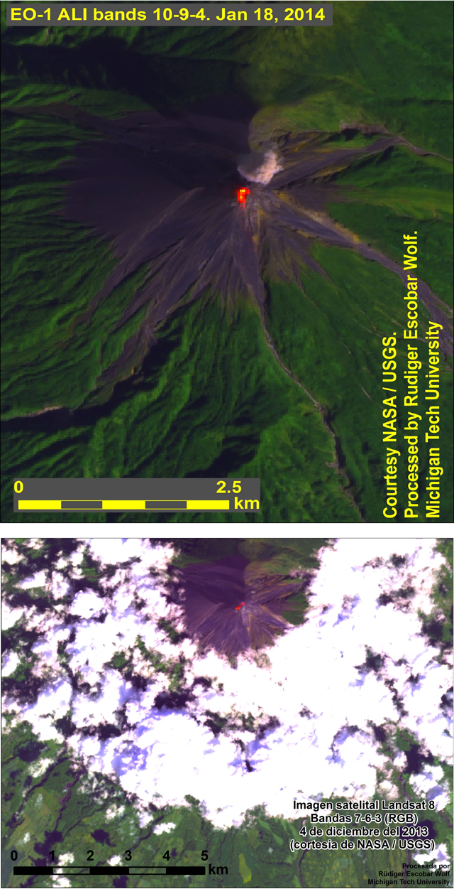 |
Figure 28. Two satellite images captured incandescence from Fuego on 18 January 2014 (top) and 4 December 2013 (bottom). (top) This EO-1 ALI image is the product of 3 bands: band 10 for thermal, band 9 for clouds, and band 4 for near-infrared. A small, round ash plume was also visible drifting NE of the summit. (bottom) This Landsat 8 image is a combination of visible and infrared bands (band 7 for near-infrared, band 6 for thermal infrared, and band 3 for chlorophyll absorption). Image processed by Rüdiger Escobar Wolf (Michigan Tech University) and acquired by NASA/USGS. |
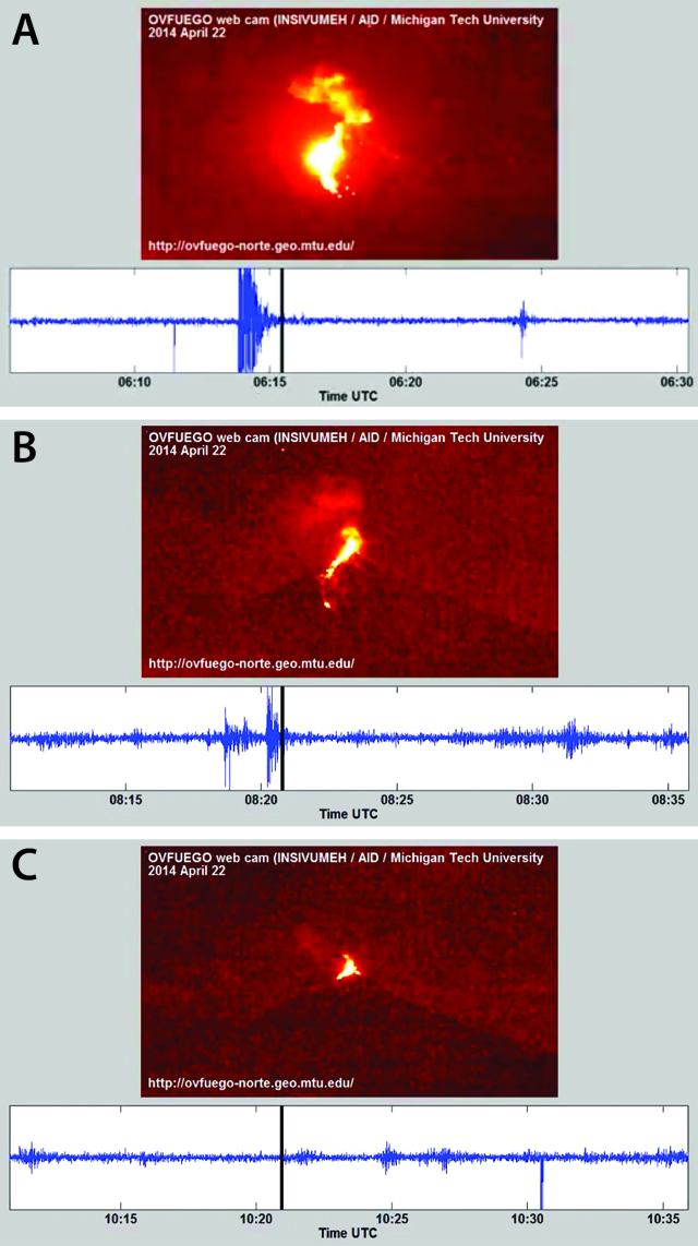 |
Figure 29. Comparisons of infrared video images with seismic traces for Fuego during 21-22 April 2014. These still views (A-C) enabled viewers to gauge the degree, timing, and correlation between major explosions accompanied by incandescence and seismic signals. The respective images coincide with the points along the seismic trace intersected with the heavy black vertical lines. Courtesy of Rüdiger Escobar Wolf (https://www.youtube.com/watch?v=mvGw7AUCtCo), INSIVUMEH, US-AID, and Michigan Tech University. |
Figure 29 shows moderate-sized (~200-m-high) incandescent plumes occurring at the time of high-amplitude seismic signals (panels A and B) whereas minor explosions (panel C) produced little-to-no seismic signal (note that no significant seismicity occurred near the 10:20 tickmark). The Michigan Tech research team postulated that the lack of seismic signal in panel C is the result of the seismometer only registering the ground coupled airwaves during the sequence as opposed to the explosion signature (personal communication by Rüdiger Escobar-Wolf). Some of the explosions recorded during this time were heard in neighboring communities.
Shockwaves from explosions, rumbling from avalanches, and ashfall from explosive events were frequently reported by inhabitants from local communities (table 9). Windows and metal roofs rattled during major events and there were such numerous reports received by INSIVUMEH from residents within 10 km of the summit.
Table 9. Ashfall from explosions at Fuego was reported in numerous communities during 27 March 2013 - 19 June 2014. A map of town locations can be found in BGVN 36:06, figure 16. Courtesy of INSIVUMEH.
| Date | Town reporting ashfall |
| 27 Mar-02 Apr 2013 | Panimaché I and II (8 km SW), Morelia (9 km SW), and Hagia Sophía |
| 28 Jun 2013 | Panimaché (8 km SW), Morelia (9 km SW), and Sangre de Cristo (8 km WSW) |
| 18 Nov 2013 | Panimaché (8 km SW), Morelia (9 km SW), and Sangre de Cristo (8 km WSW) |
| 21 Nov 2013 | Sangre de Cristo (8 km WSW) |
| 03 Jan 2014 | Panimaché (8 km SW), Morelia (9 km SW), and Sofía I and II (12 km SW) |
| 13 Jan 2014 | Panimaché (8 km SW), Morelia (9 km SW), and Sangre de Cristo (8 km WSW) |
| 02 Feb 2014 | Panimaché (8 km SW), Morelia (9 km SW), and the W flank |
| 25 Mar 2014 | Sangre de Cristo (8 km WSW) and surrounding areas |
| 22-23 Mar 2014 | Santa Sofía (12 km SW), Panimaché I and II (8 km SW), Morelia (9 km SW) |
| 10-11 Apr 2014 | Panimaché (8 km SW) and Sangre de Cristo (8 km WSW) |
| 20-22 Apr 2014 | Panimaché (8 km SW), Morelia (9 km SW), and Santa Sofía (12 km SW) |
| 25-28 Apr 2014 | Panimaché (8 km SW), Morelia (9 km SW), and Santa Sofía (12 km SW) |
| 18-19 Jun 2014 | Within 15 km of the summit, mainly El Porvenir (8 km ENE), Los Yucales (12 km SW), Santa Sofía (12 km SW), Morelia (10 km SW), and Panimaché (I and II, ~8 km SW). Also, ashfall was reported in Sangre de Cristo (8 km WSW) on 18 June. |
Thermal anomaly detection during 2013-2014. Except for June 2014, hotspots at the summit region were detected by satellite remote sensing instruments during each month of this reporting period (table 10). Platforms capturing the infrared data included MODIS (onboard the Terra and Aqua satellites), Landsat 8, and EO-1 Advanced Land Imaging (ALI).
Table 10. The MODVOLC system generated thermal alerts from Fuego during April 2013-May 2014. Courtesy of HIGP.
| Month | Pixels |
| 14 Apr 2013 | 2 |
| 21 Apr 2013 | 1 |
| 23 Apr 2013 | 1 |
| 25 Apr 2013 | 2 |
| 26 Apr 2013 | 3 |
| 27 Apr 2013 | 4 |
| 28 Apr 2013 | 9 |
| 09 May 2013 | 1 |
| 15 Jun 2013 | 1 |
| 17 Jun 2013 | 1 |
| 08 Jul 2013 | 2 |
| 10 Jul 2013 | 2 |
| 12 Jul 2013 | 1 |
| 15 Jul 2013 | 1 |
| 22 Jul 2013 | 2 |
| 26 Jul 2013 | 1 |
| 28 Jul 2013 | 2 |
| 29 Jul 2013 | 1 |
| 08 Aug 2013 | 1 |
| 09 Aug 2013 | 1 |
| 11 Aug 2013 | 1 |
| 15 Aug 2013 | 2 |
| 18 Aug 2013 | 2 |
| 19 Aug 2013 | 1 |
| 20 Aug 2013 | 4 |
| 23 Aug 2013 | 1 |
| 03 Sep 2013 | 1 |
| 14 Sep 2013 | 1 |
| 05 Oct 2013 | 1 |
| 11 Oct 2013 | 2 |
| 14 Oct 2013 | 2 |
| 04 Nov 2013 | 4 |
| 15 Nov 2013 | 1 |
| 18 Nov 2013 | 1 |
| 19 Nov 2013 | 3 |
| 20 Nov 2013 | 2 |
| 24 Nov 2013 | 2 |
| 27 Nov 2013 | 1 |
| 03 Dec 2013 | 1 |
| 05 Dec 2013 | 1 |
| 10 Dec 2013 | 2 |
| 15 Dec 2013 | 5 |
| 16 Dec 2013 | 2 |
| 28 Dec 2013 | 2 |
| 30 Dec 2013 | 1 |
| 02 Jan 2014 | 1 |
| 05 Jan 2014 | 1 |
| 07 Jan 2014 | 4 |
| 11 Jan 2014 | 1 |
| 15 Jan 2014 | 2 |
| 18 Jan 2014 | 5 |
| 20 Jan 2014 | 1 |
| 22 Jan 2014 | 1 |
| 23 Jan 2014 | 2 |
| 25 Jan 2014 | 5 |
| 28 Jan 2014 | 1 |
| 29 Jan 2014 | 2 |
| 31 Jan 2014 | 1 |
| 02 Feb 2014 | 1 |
| 04 Feb 2014 | 1 |
| 05 Feb 2014 | 5 |
| 06 Feb 2014 | 1 |
| 07 Feb 2014 | 1 |
| 08 Feb 2014 | 1 |
| 12 Feb 2014 | 1 |
| 21 Feb 2014 | 2 |
| 24 Feb 2014 | 1 |
| 01 Mar 2014 | 1 |
| 05 Mar 2014 | 1 |
| 11 Mar 2014 | 3 |
| 20 Mar 2014 | 1 |
| 21 Mar 2014 | 1 |
| 23 Mar 2014 | 4 |
| 25 Mar 2014 | 2 |
| 27 Mar 2014 | 1 |
| 28 Mar 2014 | 1 |
| 29 Mar 2014 | 1 |
| 30 Mar 2014 | 2 |
| 01 Apr 2014 | 1 |
| 15 Apr 2014 | 1 |
| 16 Apr 2014 | 1 |
| 21 Apr 2014 | 1 |
| 22 Apr 2014 | 1 |
| 27 Apr 2014 | 1 |
| 17 May 2014 | 1 |
| 18 May 2014 | 2 |
| 19 May 2014 | 2 |
Lahar hazards. Drainages within the southern sector of Fuego were frequently at risk for lahars during 2013-2014. In particular, the rivers Las Lajas, El Jute, Honda, Seca, Ceniza, Santa Teresa, and TaniluyÁ were inundated by lahars during this reporting period (table 11). A map of river locations can be found in figure 7 of BGVN 30:08.
Table 11. During May 2013-June 2014, weak- to strong-flowing lahars from Fuego were frequently triggered by heavy rainfall, mainly during May-September (the rainy season) each year. Courtesy of INSIVUMEH.
| Date | Drainages | Dimensions | Load | Damage/At risk |
| 29 May 2013 | Las Lajas & El Jute (SE) | -- | 0.5 m in diameter | -- |
| 02 Jun 2013 | Ceniza (SSW) | blocks; trees and logs | -- | -- |
| 08 Jun 2013 | Las Lajas (SE), El Jute (SE), & Ceniza (SSW) | -- | -- | -- |
| 27 Jun 2013 | Las Lajas & El Jute (SE) | -- | 1.5 m diameter blocks; branches and tree trunks | -- |
| 05 Jul 2013 | Las Lajas & El Jute (SE) | -- | 0.5 m in diameter | -- |
| 17 Aug 2013 | Las Lajas, Ceniza (SSW), & El Jute (SE) | 30 m wide | blocks | -- |
| 09 Sep 2013 | Las Lajas & El Jute (SE) | -- | 2 m diameter blocks | -- |
| 10 Sep 2013 | Taniluyá (SW) | 15-20 m wide; 1-2 m deep | Tree trunks | Roads were blocked in Panimaché I and II (8 km SW), Morelia (9 km SW), and Santa Sofía (12 km SW) for two hours. |
| 11 Sep 2013 | Las Lajas & El Jute (SE) | 30 m wide; 4 m deep | 2 m diameter blocks; branches and tree trunks | -- |
| 01 Jun 2014 | Las Lajas (SE), Honda (E), & Seca (W) | -- | -- | Traffic crossing the Río Seca was disrupted as well as the road crossing on the W and S sides. |
| 02 Jun 2014 | Las Lajas & El Jute (SE) | -- | 1.5 m diameter blocks | -- |
| 05 Jun 2014 | Honda (E), El Jute (SE), Ceniza (SSW), & Santa Teresa (S) | -- | 1.5 m diameter blocks | -- |
| 09 Jun 2014 | Las Lajas & El Jute (SE) | -- | 1.5 m diameter blocks | -- |
Geological Summary. Volcán Fuego, one of Central America's most active volcanoes, is also one of three large stratovolcanoes overlooking Guatemala's former capital, Antigua. The scarp of an older edifice, Meseta, lies between Fuego and Acatenango to the north. Construction of Meseta dates back to about 230,000 years and continued until the late Pleistocene or early Holocene. Collapse of Meseta may have produced the massive Escuintla debris-avalanche deposit, which extends about 50 km onto the Pacific coastal plain. Growth of the modern Fuego volcano followed, continuing the southward migration of volcanism that began at the mostly andesitic Acatenango. Eruptions at Fuego have become more mafic with time, and most historical activity has produced basaltic rocks. Frequent vigorous eruptions have been recorded since the onset of the Spanish era in 1524, and have produced major ashfalls, along with occasional pyroclastic flows and lava flows.
Information Contacts: Instituto Nacional de Sismologia, Vulcanología, Meteorología e Hidrologia (INSIVUMEH), Ministero de Communicaciones, Transporto, Obras Públicas y Vivienda, 7a. Av. 14-57, zona 13, Guatemala City 01013, Guatemala (URL: http://www.insivumeh.gob.gt/inicio.html); Coordinadora Nacional para la Reducción de Desastres (CONRED), Av. Hincapié 21-72, Zona 13, Guatemala City, Guatemala (URL: http://conred.gob.gt/www/); and Washington Volcanic Ash Advisory Center (VAAC), NOAA Science Center Room 401, 5200 Auth road, Camp Springs, MD 20746, USA (URL: http://www.ospo.noaa.gov/Products/atmosphere/vaac/).