Report on Kavachi (Solomon Islands) — July 2014
Bulletin of the Global Volcanism Network, vol. 39, no. 7 (July 2014)
Managing Editor: GVP Staff.
Kavachi (Solomon Islands) Plume of discolored water seen in January 2014 satellite imagery indicates probable eruption
Please cite this report as:
Global Volcanism Program, 2014. Report on Kavachi (Solomon Islands) (GVP Staff, ed.). Bulletin of the Global Volcanism Network, 39:7. Smithsonian Institution. https://doi.org/10.5479/si.GVP.BGVN201407-255060
Kavachi
Solomon Islands
8.991°S, 157.979°E; summit elev. -20 m
All times are local (unless otherwise noted)
The most recent previously observed eruption of Kavachi occurred during 2-6 April 2007 and consisted of vigorous upwelling, discolored water, and minor explosions (BGVN 32:02). On 29 January 2014, the NASA Advanced Land Imager (ALI) on the Earth Observing-1 (EO-1) satellite imaged a plume of discolored water at least 5 km long streaming ESE from the submarine volcano (figure 12). The water plume, likely discolored due to dissolved volcanic gases and suspended tephra in the water, originated at the location of the volcano. Directly above the source of the discolored water, a bright patch suggests vigorously churning water, but there was no sign that an eruption had broken the ocean surface.
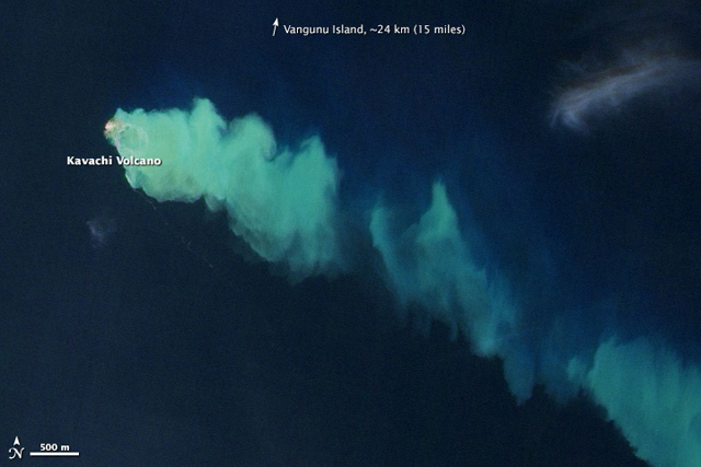 |
Figure 12. Satellite image of discolored water flowing ESE from a possible eruption of Kavachi on 29 January 2014. Note the 500 m scale bar at lower left. Courtesy of NASA Earth Observatory; image by Jesse Allen and Robert Simmon, using EO-1 ALI data from the NASA EO-1 team. Caption by Robert Simmon. |
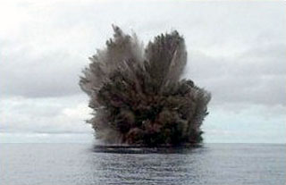
Geological Summary. Named for a sea-god of the Gatokae and Vangunu peoples, Kavachi is located in the Solomon Islands south of Vangunu Island. Sometimes referred to as Rejo te Kvachi ("Kavachi's Oven"), this shallow submarine basaltic-to-andesitic volcano has produced ephemeral islands up to 1 km long many times since its first recorded eruption during 1939. Residents of the nearby islands of Vanguna and Nggatokae (Gatokae) reported "fire on the water" prior to 1939, a possible reference to earlier eruptions. The roughly conical edifice rises from water depths of 1.1-1.2 km on the north and greater depths to the SE. Frequent shallow submarine and occasional subaerial eruptions produce phreatomagmatic explosions that eject steam, ash, and incandescent bombs. On a number of occasions lava flows were observed on the ephemeral islands.
Information Contacts: NASA Earth Observatory (URL: http://earthobservatory.nasa.gov/NaturalHazards/view.php?id=83025); NASA EO-1 team (URL: http://eo1.gsfc.nasa.gov/).