Report on Zhupanovsky (Russia) — September 2014
Bulletin of the Global Volcanism Network, vol. 39, no. 9 (September 2014)
Managing Editor: Richard Wunderman.
Zhupanovsky (Russia) Moderate explosions with ash plumes beginning October 2013
Please cite this report as:
Global Volcanism Program, 2014. Report on Zhupanovsky (Russia) (Wunderman, R., ed.). Bulletin of the Global Volcanism Network, 39:9. Smithsonian Institution. https://doi.org/10.5479/si.GVP.BGVN201409-300120
Zhupanovsky
Russia
53.589°N, 159.15°E; summit elev. 2899 m
All times are local (unless otherwise noted)
On 23 or 24 October 2013 Zhupanovsky erupted for the first time since the 1950's. The report presents the eruptive activity of Zhupanovsky from 23 October 2013 through the end of December 2014. Data were summarized from reports of the Kamchatka Volcanic Eruption Response Team (KVERT), the Tokyo Volcanic Ash Advisory Center (VAAC), and various satellite remote sensors. In addition, observations of activity were recorded by KVERT scientists, park rangers, and aviation personnel, [there is no in-situ scientific monitoring instrumentation]. Zhupanovsky lies in a volcanic region on the Kamchatka peninsula (figure 2), ~70 km N of Petropavlovsk-Kamchatsky, a city of ~200,000 inhabitants. Eruptions started on 23 October 2013 and paused during November 2013 through May 2014. [Activity] resumed in June 2014 and [continued] through the rest of 2014.
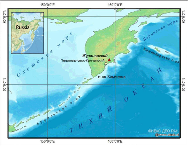 |
Figure 2. (Inset) Map of Russia's E region showing the Kamchatkan peninsula. (Main map) Zhupanovsky (red triangle) lies on the peninsula ~15 km from the Pacific coast shoreline. The city at the yellow dot is Petropavlovsk-Kamchatsky, ~70 km from the edge of Zhupanovsky. This is a Russian map of unknown authorship found online with additions by Bulletin editors. |
October 2013 eruption. On 23 October 2013, KVERT reported that a weak thermal anomaly occurred over Zhupanovsky. The next day, a phreatic eruption began at about 0300 and generated an ash plume that rose to an altitude of 5 km. The ash plume, visible in satellite images, drifted 120 km SE and S. Ash deposits ~1 mm thick covered the Nalychevo Valley bordering the S of the massif. The Aviation Color Code was raised to Orange.
On 26 October 2013, Institute of Volcanology and Seismology (IVS FEB RAS) scientists inspected the summit and found ~10 cm deep ash covered the crater area (figure 3). On 26 October, KVERT stated pilots and ground crew at Elizovo airport observed a gas-and-steam plume that may have contained ash. The plume rose to 1.5 km and drifted E. The airport, 22 km NNW from Petropavlovsk-Kamchatsky, serves commercial airlines and Russian air force planes. On 27 October KVERT noted that strong fumarolic activity and gas emissions continued, but that the phreatic explosions likely had ceased. The Aviation Color Code was lowered to Yellow, and then lowered again to Green on 29 October.
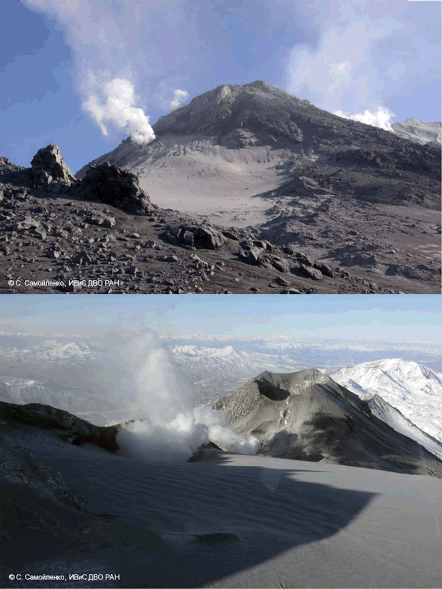 |
Figure 3. (top image) A picture of Zhupanovsky taken on 26 October 2013 below the crater looking ENE. (bottom image) On the same day, a picture taken higher up on the ridge looking into the crater. Courtesy of KVERT. Captured by S. Samoilenko, Institute of Volcanology and Seismology, Russian Academy of Sciences, Far Eastern Branch (IVS FEB RAS). |
On 5 November 2013, EO-1 satellite's Advanced Land Imager (ALI) captured an ash plume emitted from Zhupanovsky (figure 4). Ash from the 26 October eruption was deposited in the crater area. Earth Observatory analysts interpreted the plume as containing erupted ash, which traveled SE. The plume in figure 4 appears low in density; however, reliable ash detection often requires analysis of spectral data.
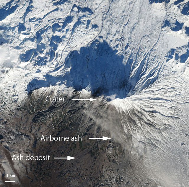 |
Figure 4. The Advanced Land Imager (ALI) remote sensor on EO-1 captured this image of Zhupanovsky on 5 November 2013. It shows ash deposited on snow and what was interpreted as a likely ongoing minor ash plume from the summit. In this natural-color image interpreted by NASA Earth Observatory analysts, snow on the high-elevation upper slopes appears white, ash deposits, dark, airborne ash, light gray, and small patches of bare rock, tan. The deep blue N of the crater is the shadow of the NE ridge of the Zhupanovsky massif. Courtesy of NASA Earth Observatory. Annotated by GVP from another version of this image previously captured, processed, and annotated by the NASA EO-1 team and NASA Earth Observatory's Jesse Allen and Robert Simmon. |
For about seven months (from 7 November 2013 to 5 June 2014), there were no KVERT weekly reports or Tokyo Volcanic Ash Advisory Center (VAAC) reports implying that Zhupanovsky had reverted to a non-eruptive state.
Eruption in 2014. On 6 June 2014, an eruption began that consisted of a series of explosions with numerous ash plumes. Throughout the rest of the year (and into 2015) Zhupanovsky remained eruptive. Of acute relevance to plume assessment towards aircraft safety, at least two plumes reached estimated altitudes near 10 km, many ash plumes extended over 100 km, and the longest one documented, near the end of November, rose to 6 km altitude and extended 422 km E to SE (table 1).
Table 1. Summary of ash plumes and other activity at Zhupanovsky registered during June-December 2014. Steaming and gas plumes were common but are often omitted here. ACC means Aviation Color Code. Cloud cover prevented observations during many days. The data were taken from KVERT reports and Tokyo VAAC notices.
| Dates (2014) | Ash plume (altitude) | Ash plume drift | Other information. |
| 6 Jun | 6 km | -- | ACC raised to Yellow. |
| 9 Jun | 3-4 km | 60 km E | -- |
| 9 and 11 Jun | -- | 100 km E | Gas-and-steam plumes. |
| 14-20 Jun | 3-8.5 km | 70 km SE, NW, NE | Thermal anomalies. ACC raised to Orange. |
| 20-26 Jun | -- | 55 km NW | -- |
| 2, 5, 9, 10 Jul | 6 km | 450 km E, SE | Gas-and-steam activity on 2 and 4 July, Ash plumes to 6 km on 9 July. An ash plume drift to 450 km SE on10 July. |
| 15-21 Jul | 3.3-6.5 km | 370 km N, 70 km NE | Thermal anomalies. Gas-and-steam plumes. During 16-18 several ash plumes were detected by satellite. |
| 25 Jul-1 Aug | 4-8.5 km | W, 150 km N | On 27 July ash plume detected by satellite |
| 6 Aug | -- | 260 km ENE | -- |
| 8-13 Aug | 3-4.9 km | E, SE, NE, ESE up to 100 km | Ash explosions twice/hr on 8 Aug. Ash plumes on 11-13 Aug. |
| 15-21 Aug | 3-4.5 km | 51 km S, 110 km SSE | Thermal anomaly. |
| 22-28 Aug | 3.5-4.3 km | 80 km SW | Thermal anomaly. |
| 29 Aug-9 Sep | 2.7-11.6 km | NW, 85 km various | Thermal anomalies. Ash fall on nearby areas. |
| 10-16 Sep | 2.4-4 km | 50-113 km S, E, 220 km SE | Thermal anomalies. |
| 19-26 Sep | 3.5-4 km | 80 km SW, NE | Thermal anomaly. |
| 26 Sep-3 Oct | 4-4.5 km | 205 km E | -- |
| 3-10 Oct | -- | -- | Thermal anomalies |
| 10-17 Oct | 9 km | 411 km NE | Thermal anomaly. Activity much decreased. Overflight on 17 Oct revealed only gas-and-steam activity. ACC lowered to Yellow. |
| 8 Nov | 10 km | 26 km SSW | Strong explosion. ACC raised to Orange. |
| 9-10 Nov | 3-4 km | 190-270 km SE | -- |
| 14-21 Nov | -- | -- | Volcano either quiet or obscured by clouds. |
| 23-27 Nov | 7-8 km | 350 km E, SE | Strong explosions on 23 and 25 Nov. Thermal anomaly. |
| 28 Nov-1 Dec | 6 km | 422 km E, SE | Thermal anomaly. |
| 5-12 Dec | -- | -- | Volcano either quiet or obscured by clouds. Thermal anomaly. |
| 12-19 Dec | -- | 70 km SE | Intense steam-and-gas emissions on 17 Dec. |
| 19-26 Dec | -- | -- | Intense steam-and-gas emissions on 24 Dec. |
| 27-31 Dec | 6-9 km | 75 km ENE | -- |
The Tokyo VAAC monitors volcanoes the Kamchatkan peninsula, detecting and tracking ash plumes through satellite imagery. During 2014, Tokyo VAAC released 176 Zhupanovsky Volcanic Ash Advisories (VAAs), often several per day (up to 5 on some days). During 2014, VAAs discussing Zhupanovsky came out during a total of 54 days (table 2).
Table 2. A compilation of the Tokyo VAACs archive of Volcanic Ash Advisories (VAAs) relating to Zhupanovsky ash plumes during 2014.
| Date (Mo/Dy) | Time (UTC) | Altitude (km) | Direction | Movement (km/hour) |
| 06 Jun 2014 | 2218Z | 6 | E | 80 |
| 09 Jun 2014 | 0330Z | 4 | E | 39 |
| 09 Jun 2014 | 0330Z | 3 | SE | 19 |
| 12 Jun 2014 | 0901Z | 2 | SE | 46 |
| 13 Jun 2014 | 0531Z | 2 | SE | 11 |
| 18 Jun 2014 | 1842Z | 3 | NW | 28 |
| 19 Jun 2014 | 1843Z | 9 | NE | 6 |
| 10 Jul 2014 | 0012Z | 6 | E | 48 |
| 16 Jul 2014 | 0239Z | 7 | N | 19 |
| 17 Jul 2014 | 1205Z | 3 | NE | 19 |
| 18 Jul 2014 | 0552Z | 4 | NE | N/A |
| 21 Jul 2014 | 0245Z | 4 | NE | -- |
| 27 Jul 2014 | 0600Z | 9 | N | 28 |
| 30 Jul 2014 | 0517Z | 5 | W | 30 |
| 11 Aug 2014 | 2125Z | 1 | SE | 30 |
| 12 Aug 2014 | 2201Z | 3 | NE | -- |
| 13 Aug 2014 | 0000Z | 5 | E | 19 |
| 19 Aug 2014 | 2012Z | 5 | S | 46 |
| 20 Aug 2014 | 0003Z | 5 | S | 56 |
| 28 Aug 2014 | 2356Z | 8 | SW | 46 |
| 29 Aug 2014 | 1251Z | 5 | S | 37 |
| 30 Aug 2014 | 0514Z | 5 | S | 28 |
| 01 Sep 2014 | 0554Z | 4 | N | 28 |
| 02 Sep 2014 | 0355Z | 5 | SW | 19 |
| 03 Sep 2014 | 0555Z | 5 | S | 28 |
| 04 Sep 2014 | 0346Z | 3 | SE | -- |
| 07 Sep 2014 | 0155Z | 12 | SW | 56 |
| 08 Sep 2014 | 0600Z | 8 | SW | 37 |
| 09 Sep 2014 | 2138Z | 3 | SE | 37 |
| 10 Sep 2014 | 0000Z | 3 | S | 37 |
| 11 Sep 2014 | 1200Z | 3 | S | 46 |
| 12 Sep 2014 | 0605Z | 3 | SE | 37 |
| 13 Sep 2014 | 2355Z | 4 | E | 37 |
| 16 Sep 2014 | 0345Z | 4 | SSW | 44 |
| 17 Sep 2014 | 1211Z | 3 | W | 28 |
| 23 Sep 2014 | 2250Z | 1 | SW | 11 |
| 24 Sep 2014 | 0010Z | 4 | SW | 19 |
| 28 Sep 2014 | 0551Z | 5 | E | 46 |
| 11 Oct 2014 | 2143Z | 8 | NE | 46 |
| 12 Oct 2014 | 0101Z | 9 | NE | 56 |
| 07 Nov 2014 | 2355Z | 12 | NE | 48 |
| 08 Nov 2014 | 1200Z | 7 | SE | 56 |
| 09 Nov 2014 | 0600Z | 4 | SE | 74 |
| 10 Nov 2014 | 1800Z | 3 | SE | 111 |
| 22 Nov 2014 | 2356Z | 8 | E | 56 |
| 25 Nov 2014 | 1800Z | 8 | SE | 28 |
| 26 Nov 2014 | 2219Z | 4 | SE | 39 |
| 27 Nov 2014 | 1155Z | 4 | SE | 37 |
| 28 Nov 2014 | 0247Z | 6 | E | 46 |
| 29 Nov 2014 | 1451Z | 4 | E | 37 |
| 30 Nov 2014 | 1155Z | 4 | E | 37 |
| 15 Dec 2014 | 2242Z | 4 | ENE | 19 |
| 28 Dec 2014 | 2348Z | 9 | ENE | 9 |
| 29 Dec 2014 | 0555Z | 9 | NE | 19 |
Some 2014 images. A Zhupanovsky eruption was captured by the Operational Land Imager (OLI) on Landsat 8 (figure 5). Several OLI images were acquired on 12 September 2014) and put together into the mosaic seen here. In addition to the eruption of Zhupanovsky on the image, four other Kamchatkan volcanoes were emitting plumes, and a forest fire was also burning (figure 5). This time interval is accounted for in table 1 with several small to moderate ash plumes and thermal anomalies during 10-16 September 2014. Table 2 tabulates a VAA issued on 12 September 2014 that documented an ash plume to ~3 km.
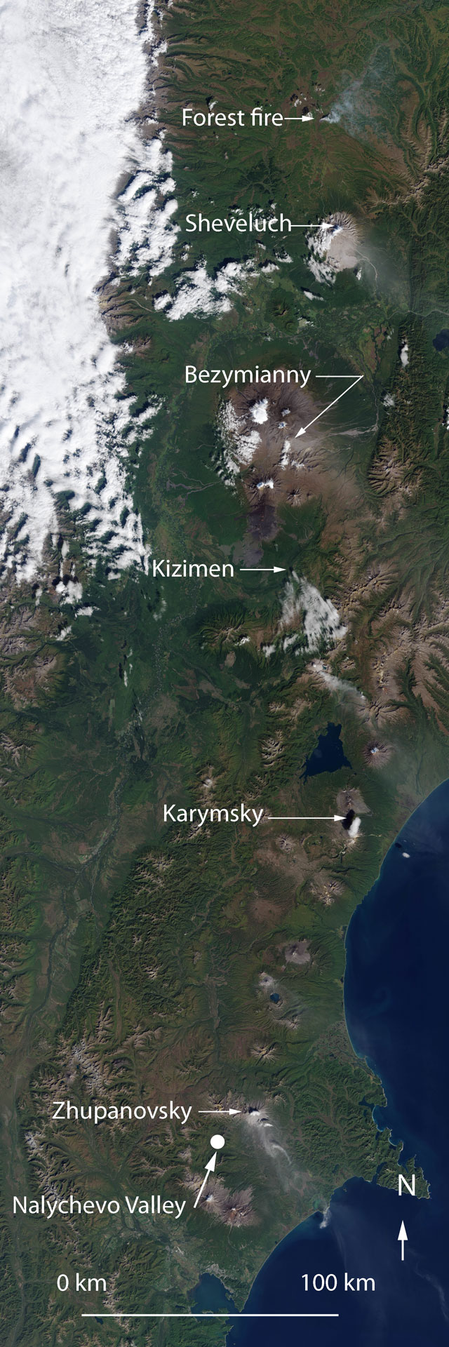 |
Figure 5. The Landsat 8 Operational Land Imager captured a consecutive series of images on 12 September 2014 that are mosaicked on this image. The mosaic was made from six images of smaller area. Zhupanovsky and four other volcanoes were emitting plumes. Smoke from a wildfire burned N of Sheveluch. About a year earlier, during 23-25 October 2013, Zhupanovsky deposited ~1 mm of ash in the Nalychevo Valley bordering the S ramparts of Zhupanovsky's E-W ridge. Courtesy of NASA Earth Observatory (Image by Jesse Allen). Annotated by Bulletin editors. |
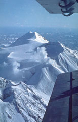
Figure 6 represents the next example of an image for Zhupanovsky, a photo of an erupting ash plume amid clear conditions on 28 November 2014. The photo's author was Russian volcanologist A. Sokorenko. The photo's caption noted explosive activity of Zhupanovsky on 28 November and calling attention to the ash coverage on the volcano's slopes
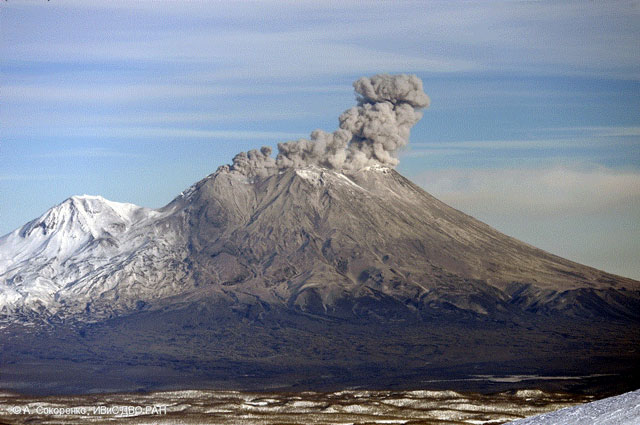 |
Figure 6. A photo taken (at 0015 UTC) on 28 November 2014 showing Zhupanovsky's ash covered slopes and an emerging ash plume. Copyrighted photo by A. Sokorenko, Institute of Volcanology and Seismology FEB RAS. |
General Reference. Girina, OA, Manevich, AG, Melnikov, DV, Demyanchuk, YV, and Petrova, E., 2014, Explosive Eruptions of Kamchatkan Volcanoes in 2013 and Danger to Aviation. In EGU General Assembly Conference Abstracts, Vienna, Austria [May 2014], Vol. 16, p. 1468
Geological Summary. The Zhupanovsky volcanic massif consists of four overlapping stratovolcanoes along a WNW-trending ridge. The elongated complex was constructed within a Pliocene-early Pleistocene caldera whose rim is exposed only on the eastern side. Three of the stratovolcanoes were built during the Pleistocene. An early Holocene stage of frequent moderate and weak eruptions from 7,000 to 5,000 years before present (BP) was followed by a period of infrequent larger eruptions that produced pyroclastic flows. The last major eruption took place about 800-900 BP. Recorded eruptions have consisted of relatively minor explosions from Priemysh, the third cone from the E about 2.5 km from the summit peak.
Information Contacts: Kamchatka Volcanic Eruption Response Team (KVERT) (URL: http://www.kscnet.ru/ivs/kvert/index_eng.php); Tokyo Volcanic Ash Advisory Center (VAAC) (URL: http://ds.data.jma.go.jp/svd/vaac/data/ ; Institute of Volcanology and Seismology Russian Academy of Sciences, Far Eastern Branch (IVS FEB RAS), 9 Piip Blvd., Petropavlovsk-Kamchatsky 683006, Russia (URL: http://www.kscnet.ru/ivs/eng/); S. Samoilenko (IVS FEB RAS), and Jesse Allen and Robert Simmon, NASA Earth Observatory (URL: http://earthobservatory.nasa.gov/).