Report on Piton de la Fournaise (France) — February 2015

Bulletin of the Global Volcanism Network, vol. 40, no. 2 (February 2015)
Managing Editor: Richard Wunderman.
Piton de la Fournaise (France) June 2014 and February 2015 eruptions
Please cite this report as:
Global Volcanism Program, 2015. Report on Piton de la Fournaise (France) (Wunderman, R., ed.). Bulletin of the Global Volcanism Network, 40:2. Smithsonian Institution. https://doi.org/10.5479/si.GVP.BGVN201502-233020
Piton de la Fournaise
France
21.244°S, 55.708°E; summit elev. 2632 m
All times are local (unless otherwise noted)
Piton de la Fournaise is located on Réunion island, which lies to the E of Madagascar in the Indian Ocean (figure 84). In this Bulletin, we discuss eruptions in June 2014 and February 2015. The June 2014 eruption took place on 21 June, from 0135 to 2109 local time. The February 2015 eruption occurred from 1100 local time on 4 February to 2230 local time on 15 February. In this report, all times are local unless otherwise stated (local time= UTC + 04 hours). This report represents a synthesis of available information published by Observatoire Volcanologique du Piton de la Fournaise (OVPDLF).
Our last Bulletin report on Piton de la Fournaise (BGVN 37:03) documented increased seismicity and eruptive activity from August to December 2010. Piton de la Fournaise's last eruption took place from 14 October 2010 through 10 December 2010 (BGVN 37:03).
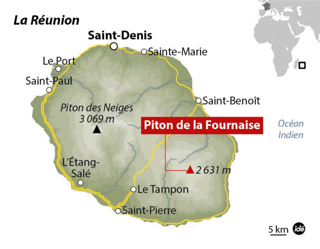 |
Figure 84. Map of Reunion Island, highlighting the location of Piton de la Fournaise, a basaltic shield volcano. As shown in the inset map (top right corner), Reunion is located to the E of Madagascar. Courtesy of Observatório Vulcanológico Geotérmico Açores. |
June 2014. Piton de la Fournaise erupted on 21 June 2014, ending a three and a half year period of quiescence that began on 11 December 2010.
Preceding the eruption, Piton de la Fournaise experienced a period of high activity from 7 to 20 June 2014. Table 4 details the number of volcano-tectonic (VT) earthquakes and rock-fall events recorded during this interval. The greatest number of daily VT earthquakes was recorded on 20 June, and highest number of rock-fall events occurred on 17 June. Through email correspondence, OVPDLF personnel reported that over this period (7-20 June), no deformation or significant gas emissions were detected. They also reported that observed seismicity occurred between 500 and 1,200 m above sea level (a.s.l.).
Table 4. The number of volcano-tectonic (VT) earthquakes and rock-fall events recorded at Piton de la Fournaise from 7 to 20 June 2014, which was considered a period of high activity. Source: email correspondence with OVPDLF personnel.
| Date | Volcano-tectonic (VT) earthquakes | Rockfall events |
| 07 Jun 2014 | 3 | 27 |
| 08 Jun 2014 | 1 | 25 |
| 09 Jun 2014 | 8 | 29 |
| 10 Jun 2014 | 20 | 41 |
| 11 Jun 2014 | 53 | 53 |
| 12 Jun 2014 | 45 | 67 |
| 13 Jun 2014 | 125 | 261 |
| 14 Jun 2014 | 32 | 93 |
| 15 Jun 2014 | 35 | 87 |
| 16 Jun 2014 | 54 | 97 |
| 17 Jun 2014 | 207 | 415 |
| 18 Jun 2014 | 38 | 32 |
| 19 Jun 2014 | 51 | 54 |
| 20 Jun 2014 | ~346 | 80 |
On 21 June 2014, at 0006, a seismic crisis began and continued for 74 minutes (email correspondence). Then at 0020, deformation began and persisted for ~3 hours (email correspondence). At 0120, tremor was detected and, at 0135, an eruption began as verified by OVPDLF cameras, which captured incandescence given off by the eruption (email correspondence). The venting took place within Enclos Fouqué on the ESE side of the central cone (figure 85) (email correspondence). OVPDLF reported that the eruptive fissures on the cone's ESE side sat between the Maillard crater and a small plateau at ~2300 m altitude (figure 85) (OVPDLF, 2014a).
During the morning of 21 June, a helicopter flyby noted (a) the presence of two eruptive fissures. From the more active fissure, small lava fountains emanated and built a spatter rampart; (b) two lava flows developed and traveled more than 1.5 km from the more active fissure. One of the flows, continued moving ~250 m E after passing the Langlois crater and the other flow continued ~500 m E-S after passing the Langlois crater (the Langlois crater is located ~2 km SE of the Dolomieu crater, figure 85); and (c) a very dilute SO2 plume extended N (OVPDLF, 2014a).
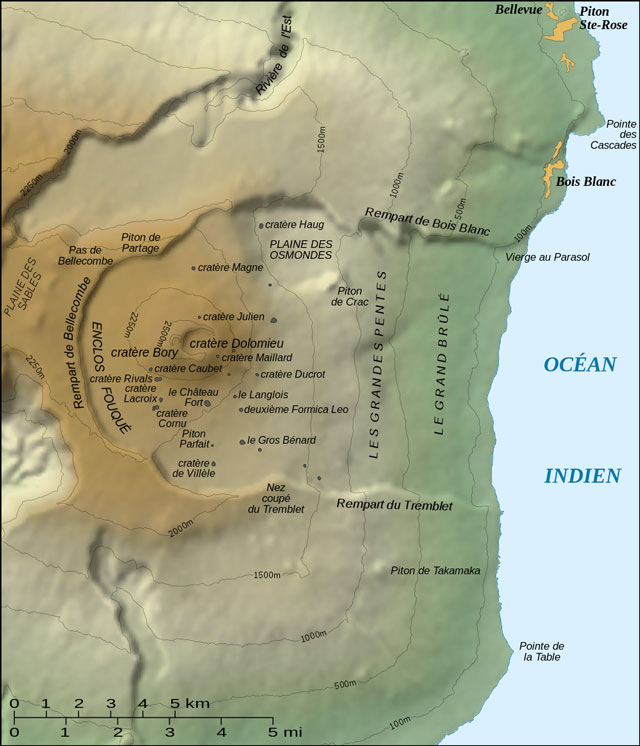 |
Figure 85. Topographic map of Piton de la Fournaise, which includes the names of features associated with the volcano (the labelling on the map is in French; cratère translates to crater in English). From Gaba (2007). |
During 21 June 2014, OVPDLF raised the Alert Level to 1 ("probable or imminent eruption"), and public access to the volcano was restricted. According to email correspondence with OVPDLF personnel, the eruption ended at 2109 on 21 June. OVPDLF further reported that the intensity of the detected tremor decreased during the day and disappeared at 2109 (OVPDLF, 2014a).
November and December 2014. On 2 December 2014, OVPDLF published an activity report (OVPDLF, 2014b), which indicated the following, (a) 113 VT earthquakes were recorded between 1 November and 1 December, with the highest number of earthquakes being recorded on 1 November (figure 86); (b) the majority of the earthquakes were located between 500 and 1,000 m a.s.l. at the base of Piton de la Fournaise's summit; (c) deformation registered by OVPDLF's geodetic network remained the same since September 2014; and (d) since 1 September 2014, the geochemical station at the summit detected low emissions of SO2 that were often coupled with CO2, H2O and H2S. That report also stated that on 1 November 2014, the hazard status "Vigilance Volcanic phase" was initiated due to increased geophysical activity. OVPDLF (2014b) stated that this status was lifted on 1 December 2014.
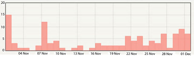 |
Figure 86. Histogram of the number of volcano-tectonic earthquakes recorded from 1 November 2014 to 1 December 2014. A total of 113 VT earthquakes were recorded over this interval and the highest number of earthquakes was recorded on 1 November 2014. Courtesy of OVPDLF (2014b). |
February 2015. The next eruption at Piton de la Fournaise began on 4 February 2015. The information in this section was found in the reference, OVPDLF (2015), unless otherwise stated. Between 0400 and 0900 on 4 February, 180 earthquakes were recorded, five of which had magnitudes greater than 2. At 0910, a seismic crisis started and at 1050, a volcanic tremor began. Ten minutes later, at 1100, an eruption began at an eruptive fissure on the S flank of Piton de la Fournaise's cone within Enclos Fouqué. Due to the eruption, Alert Level 2-2 ('ongoing eruption') was declared.
On 5 February 2015, the eruption continued even though the intensity of the tremor had decreased since its initiation on 4 February. OVPDLF reported that the eruptive fissure formed 100 m W of Bory crater (figures 85 and 87). The fissure had a length of ~500 m and activity was reported to be concentrated at its southernmost end. The fissure emitted a lava flow that traveled S-SW, and after passing Rivals crater, it divided into several branches as it continued to spread farther S and SW (figure 87). The southernmost branch of the flow traveled passed Cornu crater (figure 85). That evening, at 1800 local time, the tremor had significantly decreased in intensity. The intensity of the tremor was about six times lower than it was at the beginning of the eruption. The eruptive fissure remained active and projected lava ~10 m high.
The eruption continued on 6 February 2015. The tremor intensity was still very low and the lava flow and its branches were still active. OVPDLF reported that during field observations, there was low levels of outgassing and material projected from eruptive vents had built small cones. On 8 February, the eruption continued and low magnitude earthquakes located in the upper part of Piton de la Fournaise reappeared. Despite poor weather, OVPDLF observed that lava continued flowing from the vents and one flow traveled farther W. By 9 February, no significant changes were noted and by late morning, the eruptive fissure was weakly active and only small splashes of lava were observed.
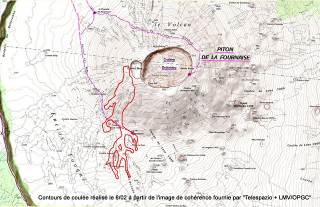 |
Figure 87. Map highlighting the margins of the lava flow and its branches in red as of 8 February 2015. For scale, the Dolomieu crater is ~1.0 km in E-W diameter. The lava that fed this flow was emitted from an eruptive fissure 100 m W of Bory crater. On the map, Bory crater is the small indent to the left of the larger Dolomieu crater. The flow length is ~2.4 km. Although the eruption continued until 15 February, there was little change to the basic pattern of the lava flow and its branches according to OVPDLF. Courtesy of OVPDLF. |
The eruption continued in a similar manner until 15 February 2015. Between 10 and 15 February, OVPDLF reported that the tremor remained low and there were no significant changes in other recorded geophysical parameters. During this interval, poor weather conditions sometimes hindered observations. On the morning of 14 February, due to the absence of clouds, OVPDLF observed a clear plume rising between 2.8 and 3 km in altitude, and concluded it was probably rich in water vapor.
In the morning of 15 February, the tremor was low and stable, and equivalent to what was recorded in previous days. According to OVPDLF, at 1700 on 15 February, the tremor began to decrease in intensity. The tremor then underwent a few hours of rapid fluctuations in its intensity, before disappearing at 2230. With the disappearance of the tremor, the eruption ended. The following day, Volcano Discovery reported that the Alert Level had been lowered.
References. Gaba, E. (Wikimedia Commons user, Sting), 2007, Topographic map of the Piton de la Fournaise shield volcano on the Réunion island, Wikipedia (initial image from the NASA Shuttle Radar Topography Mission), URL: http://commons.wikimedia.org/wiki/File:Piton_Fournaise_topo_map-fr.svg#/media/File:Piton_Fournaise_topo_map-fr.svg, accessed on 27 May 2015
OVPDLF, 2014a, Actualités (News), URL: http://www.ipgp.fr/fr/ovpf/actualites-ovpf, accessed in June 2014
OVPDLF, 2014b, Bilan d'activité à la levée de la vigilance volcanique (Activity report to the lifting of the volcanic alert), URL: http://www.ipgp.fr/fr/OVPDLF/communique-de-lOVPDLF-2-decembre-2014, accessed on 10 June 2015
OVPDLF, 2015, Archive actualités (News Archive), URL: http://www.ipgp.fr/fr/OVPDLF/archive-actualites, accessed on 27 May 2015
Observatório Vulcanológico Geotérmico Açores, 2015, Notícia 1682 - Vulcão Piton de la Fournaise, Ilha da Reunião: nova erupção registada este domingo (News No. 1682 - Piton de la Fournaise volcano, Reunion Island: new recorded eruption on Sunday), URL: http://ovga.centrosciencia.azores.gov.pt/sites/default/files/Map_ide-reunion-piton-de-la-fournaise.jpg, accessed on 10 June 2015
Volcano Discovery, 2014, Piton de la Fournaise volcano (La Réunion): eruption ends, URL:
http://www.volcanodiscovery.com/piton_fournaise/news/45631/Piton-de-la-Fournaise-volcano-La-Runion-eruption-ends.html, accessed on 27 May 2015
Volcano Discovery, 2014, Piton de la Fournaise volcano (La Réunion): alert level raised, eruption warning, URL: http://www.volcanodiscovery.com/piton_fournaise/news/49537/Piton-de-la-Fournaise-volcano-La-Runion-alert-level-raised-eruption-warning.html, accessed on 27 May 2015
Volcano Discovery, 2015, Piton de la Fournaise volcano (La Réunion): eruption seems to have ended, URL: http://www.volcanodiscovery.com/piton_fournaise/news/51262/Piton-de-la-Fournaise-volcano-La-Runion-eruption-seems-to-have-ended.html, accessed on 27 May 2015.
Geological Summary. Piton de la Fournaise is a massive basaltic shield volcano on the French island of Réunion in the western Indian Ocean. Much of its more than 530,000-year history overlapped with eruptions of the deeply dissected Piton des Neiges shield volcano to the NW. Three scarps formed at about 250,000, 65,000, and less than 5,000 years ago by progressive eastward slumping, leaving caldera-sized embayments open to the E and SE. Numerous pyroclastic cones are present on the floor of the scarps and their outer flanks. Most recorded eruptions have originated from the summit and flanks of Dolomieu, a 400-m-high lava shield that has grown within the youngest scarp, which is about 9 km wide and about 13 km from the western wall to the ocean on the E side. More than 150 eruptions, most of which have produced fluid basaltic lava flows, have occurred since the 17th century. Only six eruptions, in 1708, 1774, 1776, 1800, 1977, and 1986, have originated from fissures outside the scarps.
Information Contacts: Observatoire Volcanologique du Piton de la Fournaise (OVPDLF), Institut de Physique du Globe de Paris, 14 route nationale 3, 27ème km, 97418 La Plaine des Cafres, La Réunion, France (URL: http://www.ipgp.fr/fr/OVPDLF/observatoire-volcanologique-piton-de-fournaise); Nicolas Villeneuve, OVPDLF.