Report on Asosan (Japan) — February 2015
Bulletin of the Global Volcanism Network, vol. 40, no. 2 (February 2015)
Managing Editor: Richard Wunderman.
Asosan (Japan) Ongoing emissions leading to a larger, late-2014 eruption with ashfall
Please cite this report as:
Global Volcanism Program, 2015. Report on Asosan (Japan) (Wunderman, R., ed.). Bulletin of the Global Volcanism Network, 40:2. Smithsonian Institution. https://doi.org/10.5479/si.GVP.BGVN201502-282110
Asosan
Japan
32.8849°N, 131.085°E; summit elev. 1592 m
All times are local (unless otherwise noted)
This report summarizes behavior at Naka-dake (Nakadake) crater at Asosan (Aso, Aso-san) caldera chiefly during January 2014-February 2015. During this reporting interval Naka-dake continued to emit gas, steam, and small ash plumes. A larger eruption took place starting 25 November 2014, causing ashfall and glowing emissions. This closed a local airport, and triggered hundreds of reports on ash plumes for the aviation community by the Tokyo Volcanic Ash Advisory Center (VAAC). That eruption continued through 2014. The eruption went on into 2015 but was generally described as intermittent during late December 2014 through at least the end of February 2015. The Alert Level remained at 2 (on a scale increasing from 1 to 5) for the duration of the reporting interval. Our last report, BGVN 37:08, described the emission of ash plumes and other behavior during May-June 2011. Some remarks in this report also refer to earlier behavior, for example, a short subsection includes what JMA recorded as important in a terse summary of 2011.
Eruption details were extracted and synthesized mainly from Japan Meteorological Agency (JMA) sources. JMA frequently communicated with the Tokyo VAAC about Asosan's eruptive status. This report also discusses Volcano Ash Advisories (VAAs) issued by the JMA's Tokyo VAAC. For many of the VAAs, evidence of ash-bearing plumes reported by JMA could not be reliably detected in the satellite images. For example, the images were sometimes obscured by overlying weather-cloud cover. The plumes were also generally only rising to a few kilometers in altitude. In at least some cases, the low plumes appeared bent by high winds.
Naka-daka Crater Number 1 remained the active vent for the most part during the past eight decades. That same pattern held true during this reporting interval when myriad small eruptions, often to or below 1 km above the crater rim were documented. Visibility was sometimes impaired but monitoring instrumentation confirmed a pattern of ongoing eruption. In some cases, the eruption was not clearly seen but fresh ash was recorded. Webcameras regularly documented incandescence both in the crater and onto the crater rim. Smaller ash plumes were too numerous to mention except in occasional cases. High winds were often mentioned, which may have bearing on restricting plume heights.
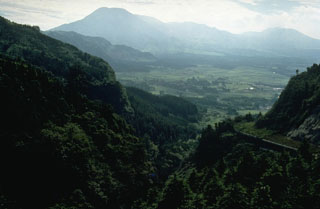
Location and brief background. Asosan is located on the S of the main island of Japan (Honshu) on the island of Kyushu (figure 32).
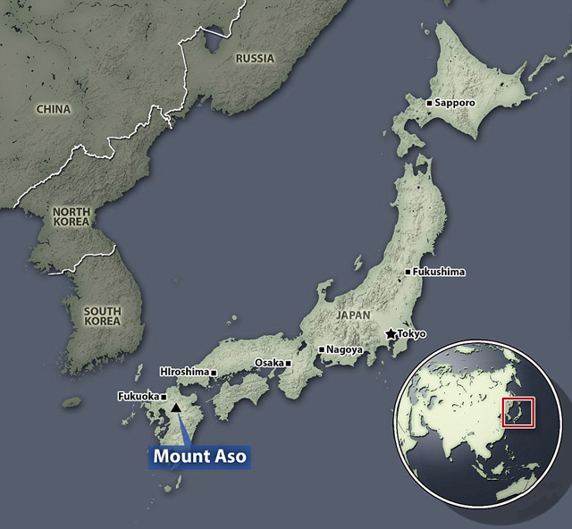 |
Figure 32. Location maps showing (circular 'global' inset) Japan, and (larger map) the location of Asosan (Aso) on Kyushu island. Taken from The Daily Mail news article issued on 28 November 2014 (Malm, 2014). |
The rim of Nake-dake is unusually developed for such an active volcano. Both a road and cable car carry tourists there. Shelter dugouts are provided around the crater. The Aso Volcano Museum is located nearby. Figure 33, made from radar imagery, shows Asosan's morphology.
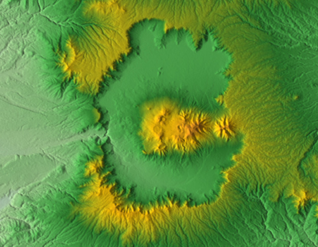 |
Figure 33. Morphology of the Asosan caldera seen in shaded relief (color scale for elevations absent). N is towards the top; the N-S cross-caldera distance is ~25 km. Note the central highlands, a series of ~17 post-caldera cones that includes the active Nake-dake and its Crater Number 1. The caldera's topographic boundary is distinct on all sides but a drainage has breached the W side. This caldera vented four sets of massive eruptive deposits (pyroclastic-flows and associated ash-falls; Miyabuchi, 2013; Fujii, 2001). Source: Wikipedia (from a Nasa Shuttle Radar Topography Mission). |
JMA (2013) includes a map showing the location of 12 calderas in Japan. Asosan, the largest and most active, has had many small eruptions in the past few thousand years, including many witnessed eruptions in the interval of recorded history. Spica (2013) discusses Aso in the context of other calderas in the Kyushu region. Figure 34 shows a shaded-relief map focusing on the post-caldera cones in the central highland area.
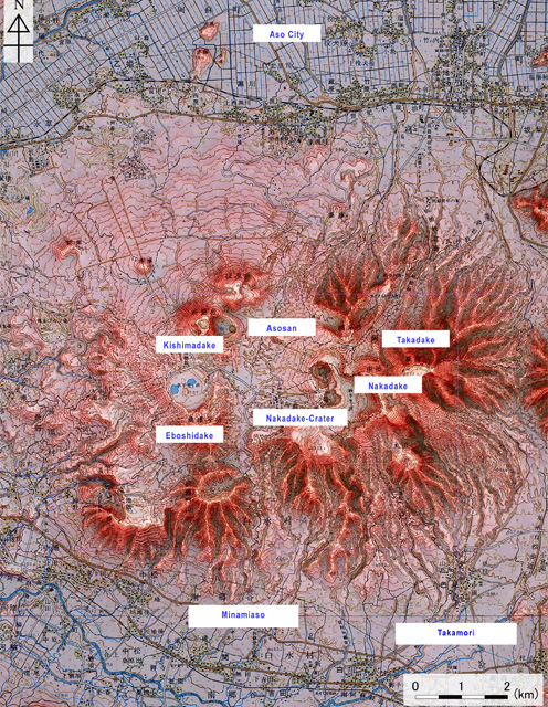 |
Figure 34. A shaded relief map of the elevated central area (post-caldera cones and their craters) of the Aso caldera, adding naming labels in English of some of the main features. As seen in the previous figure, the caldera floor (moat) is outside and encircling this central topographic high. Both conventional topographic and a digital elevation map (50 m grid) were used to make this map, which was published by the Geospatial Information Authority of Japan. Source: JMA (2013). |
JMA's website features this summary on Asosan.
"Asosan (Aso Volcano) comprises the Aso caldera and post-caldera central cones. The Aso caldera, 25 km north-south and 18 km east-west in diameter, was formed by four gigantic pyroclastic-flow eruptions from approximately 270,000 to 90,000 years ago. Post-caldera central cones were initiated soon after the last caldera-forming eruption, producing not only local lava flows but also voluminous tephra layers which fell far beyond the caldera. Nakadake Volcano, which is the only active central cone of basaltic andesite to basalt [composition], is one of the most active volcanoes in Japan. The active crater of Nakadake Volcano is a composite of seven craterlets aligned N-S [elongate zone of depressions to the left of the label "Nakadake" and above the letter 't' in the label "Nakadake-Crater" on figure 34; see also SEAN 04:07 for a sketch map focused on this area)]. Only the northernmost [Nakadake] crater (No. 1 crater) has been active in the past 80 years, although some others were active before the 1933 eruption. The Nakadake No. 1 crater is occupied by a hyperacidic crater lake during its calm periods. During active periods, its volcanic activity is characterized by ash and strombolian eruptions and phreatic or phreatomagmatic explosions."
According to Fujii and others (2001), "Aso caldera in central Kyushu, Japan, is one of the largest calderas in the world and covers an area of 380 km2. In late Pleistocene time, eruptions of voluminous pyroclastic flows occurred intermittently, resulting in formation of the caldera. The Aso pyroclastic-flow deposits are divided into four major units, i.e. Aso-1, Aso-2, Aso-3, and Aso-4 . . . [and] welded tuffs of these units are widely distributed in central Kyushu, and are generally well suited for paleomagnetic research . . .. K-Ar ages for Aso-1, Aso-2, Aso-3, and Aso-4 have been determined to be 266 ± 14 ka, 141 ± 5 ka, 123 ± 6 ka, and 89 ± 7 ka, respectively (Matsumoto and others, 1991)."
JMA summary for 2011 activity. JMA (2013) tabulated a summary of witnessed events (eruptions, possible eruptions, damage, significant behavior, etc.) at Asosan going back to the year 553. In the most recent behavior discussed, the authors briefly note that during 2011 (an interval they term Heisei 23) the following behavior occurred.
First, after the Mw ~9 Tohoku earthquake ~70 km off the Pacific coast on 11 March 2011, earthquakes temporarily increased roughly 10 km to the NW of the active crater. Second, very small emissions of gray-white volcanic ash occurred during 15 May to 9 June 2011. On 15 May a very small amount of tephra fall was confirmed at Sensuikyo, ~2 km to the NE of the Nakadake Number 1 crater.
2014 Activity. JMA reporting for 13 January 2014 noted the emission of a very small eruption. This came in the wake of increased tremor in late December 2013 and an increase in hazard status to Alert Level 2. (As previously mentioned, the Level remained at 2 for the duration of the reporting interval.) Further escalation in tremor took place on 2 January. On 10 January emissions reached 1,200 metric tons/day (t/d) of sulfur-dioxide (SO2). The 13 January 2014 eruption took place at Naka-dake, which emitted a grayish-white plume that rose to 600 m that traveled S and deposited traces of ash. The resulting report from the Tokyo VAAC (a Volcanic Ash Advisory (VAA)) stating they failed to detect identifiable ash in the plume data captured on satellite images.
The small 13 January 2014 eruption triggered the first Asosan VAA in over a year. The other VAAs during January 2014 were issued on the 27th, 29th, 30th, and 31st. On one of those days, two VAAs were issued, and thus, for January there were 6 VAAs.
Bulletin editors note that the VAAs are not a linear measure of the number of eruptions. Small eruptions may not trigger a VAA at all. Several consecutive VAAs may occur associated with a single potentially larger eruption, which are issued in an effort to track an ash plume. Again, this may be an example where the number of VAAs is not reflective of the number of eruptions. Despite this, the number of VAAs are easily counted owing to new online archives. The Tokyo VAACs online presentation system is tablular in nature and is thus well suited to enable a count of reports per month.
The tally for VAAs on Asosan during 2013 was zero. The tally for 2014 involved 171 VAAs. Monthly totals for 2014 are as follows: January, 6; February, 3; March-July, 0; August, 3; September, 2; October, 0; November, 25; and December, 132. For further comparison, the tally for January and February 2015 involved 250 VAAs, with January, 132, and February, 118.
JMA reported that seismicity increased from 21 to 23 January 2014, and then decreased on 24 January. On 23 January a volcanologist observed ash plumes rising from the central vent on the crater floor. On 29 January an ash plume reported by a pilot rose to 2.7 km altitude and drifted NW. Later that day a plume rose to an altitude of 1.5 km and drifted N. JMA reported that a very small Asosan explosion occurred on 31 January. An off-white plume rose 100 m above the crater rim and drifted S.
On 5 February 2014 scientists measured decreased SO2 emissions and fewer volcanic earthquakes.
According to the Tokyo VAAC during 30 August-1 September 2014 eruptions continuously emitted ash plumes that rose to heights of 1.2-2.1 km drifting N and NE. For example, on 1 and 6 September eruptions emitting trace amounts of ash sent plumes 600 m above the rim. (Tokyo VAAC issued VAAs stating this plume lacked identifiable ash in available satellite images.) JMA instrument surveys established SO2 flux rates on 21 August of 1,000 t/d, and in early September of 1,200 tons/day. Counts tallying daily volcano-tectonic earthquakes (and cases of tremor) were made during 1-4 September occurring in the range 48-92 (429-500); during 5-7 September occurring the in the range 55-129 (401-463); during 8-15 September occurring in the range 394-564 (80-174).
JMA reported that during 8-16 September a persistent white plume was observed 1 km above the crater.
Preliminary counts for volcanic earthquakes (394-564 per day) and tremor (80-174 per day) were reported during 8-15 September. Field surveys conducted on 9 and 12 September yielded elevated temperatures from fumaroles and the surface of the S crater wall.
Tremor accompanied a very small eruption recorded on 22-24 October. Ashfall observed on the 24th indicated another such eruption.
During 7 September and 24 November 2014, VAAs were absent for Aso. In contrast, during 25 November 2014-31 December 2014 there were 171 VAAs issued. Multiple VAAs were issued on several different days in this later interval, for example, on 26 November, 7 VAAs were issued.
Asosan continued to erupt during the 7 September-24 November 2014 interval. Some monitored parameters such as earthquakes, tremor, and SO2 emissions were elevated. A small eruption took place on 6 September, for example, sending a plume to 600 m above the crater. During 8-16 September JMA noted a persistent white plume 1 km above the crater. During the week 12-18 November, a steam plume rose 400 m above the crater rim.
With the start of the surge in VAAs beginning on 25 November 2014 (noted above), a stronger and comparatively sustained eruption began. During the eruption on the 25th an ash plume rose to 1.8 km above the crater rim. Ash soon fell to the E in Hanoi Aso (Kumamoto Region), Taketa (30 km NE, Oita Region), Gokase (25 km WSW, Miyazaki Region), and in Minamiaso (10 km SW, Kumamoto Region). Incandescence at night was seen with webcams.
On 26 November tephra ascended 100 m above the crater rim and an ash plume rose 1 km. Tremor began a few hours before the eruption and on the 26th, continued to be elevated. The eruption continued on 27 November; ash plumes rose 1.5 km. Volcanologists observed a strombolian eruption and found 7 cm of fresh ash that contained fist-sized scoria. Ash fell to the W, affecting the city of Kumamoto (38 km WSW). According to a news article, flights in and out of Kumamoto airport were either cancelled or diverted. On 28 November ash plumes rose 1.5 km. The eruption continued through at least 30 November; ash plumes rose at most 1.5 km and incandescent material was ejected onto the crater rim.
Although inclement weather restricted views of the crater, monitored parameters and available views indicated that the 25 November eruption continued through to at least 22 December, when it became intermittent. Ash plumes to about 1 km above the crater rim and incandescent material on the crater rim were common through the end of the year (and beyond, through this reporting interval ending in February 2015, and described as the ongoing eruption.
A news report in the 28 November 2014 issue of the Daily Mail by Sara Malm (Malm, 2014) indicated dozens of cancelled flights at Kumamoto's airport. That report included the Associated Press photo seen in figure 35. The date of the photo in that article was ambiguous, but a different article with the same photo (see caption) gave 26 November 2014 as the photo's date. The angled, bent-over character of the ash plume and location of Crater Number 1 (the active crater, at the N end of the row of craters) indicate the view was from the NW and implies strong winds roughly from the N.
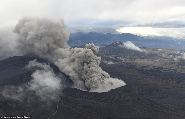 |
Figure 35. A photo taken on 26 November 2014 of Asosan in eruption. The gray ash plume is escaping at Nake-dake Crater Number 1 blowing roughly S. The plume does not rise vertically. The plume ascends near the vent but for some distance beyond the vent the plume descends. At distance the plume appears to spread over considerable vertical extent, from near the ground surface to above the field of view. Source: Phys.Org news (crediting AP/Kyodo News). |
An undated video in Malm (2014) also showed the plume. The video also showed an aerial view of the visitor area on the crater rim, which was blanketed in gray ash. Other scenes included children walking to school wearing dust masks and carrying folded umbrellas, and close up shots of what appeared to be dark colored, highly vesicular spatter.
In a 29 November 2014 MODIS image of the region, Asosan was under weather clouds but a clear view revealed a prominent ~30-km-long, beige-colored, funnel-shaped area trending SE. This was interpreted by Nasa Earth Observatory authors Jeff Schmaltz and Adam Voiland as airborne ash. Webcamera images around this time showed a glowing pit crater with extensive areas containing incandescent tephra around it. A copious plume also discharged nearby.
During a field survey on 10 December volcanologists observed 20-cm-wide blocks near the crater and 5- to 10-cm-wide blocks within 1.2 km SW of the crater. During 12-15 December the plume rose 1 km above the crater rim and ash fell to the E in Hanoi Aso (Kumamoto Region).
JMA reports for 15-30 December described the usual eruptive ash plumes that again rose 600-1,000 m above the crater and some cases of still glowing material on the crater rim. SO2 fluxes were 2,000-3,100 t/d during 15 and 18 December.
2015 activity. As noted above, the VAAs for 2014 totaled 171, and the VAAs for the months of January and February 2015 totaled 250. This is consistent with ongoing eruption at Asosan, which was also the basic conclusion in JMA reports from monitoring and direct observations during January-February 2015, although they often described the eruption during both these months as intermittent.
JMA reported cases during January where plumes rose up to 1 km above the crater, and in some cases glowing material reached the crater rim. JMA reported SO2 fluxes of 500-2600 tons of SO2. Both tilt and GPS instrumentation recorded slight growth across the active crater. A pilot report on 29 January indicated an ash plume to 2.7 km altitude (~1.1 km above the rim) and drifting NW.
An image acquired on 13 January 2015 was discussed by Jesse Allen and Adam Voiland of Nasa Earth Observatory. They reported that the image was from the Operational Land Imager (OLI) on Landsat 8. They indicated that it showed ash drifting ten's of kilometers S from Aso.
For February 2015, JMA reported episodes of volcanic earthquakes, high-amplitude tremor, and infrasound data that continued to indicate ongoing intermittent eruptions. Webcamera views again documented cases of glowing material reaching the rim during the first half of the month. Plumes again rose up to 1 km above the crater rim. JMA reported intermittently detected eruptions, including during 2-6, 9-13, and 16-20 February.
References.
Fujii, J., Nakajima, T., & Kamata, H., 2001, Paleomagnetic directions of the Aso pyroclastic-flow and the Aso-4 co-ignimbrite ash-fall deposits in Japan. Earth, planets and space, 53(12), 1137-1150. (URL: http://download.springer.com/static/pdf/873/art:10.1186/BF03352409.pdf?originUrl=http://link.springer.com/article/10.1186/BF03352409&token2=exp=1434307643~acl=/static/pdf/873/art:10.1186/BF03352409.pdf?originUrl=http://link.springer.com/article/10.1186/BF03352409*~hmac=b718e24427a5900c5057d59ebb12b501c1ae870b932122de89cc3a01a5f5318f ).
JMA (Japan Meteorological Agency), 2013, National Catalog of the Active Volcanoes of Japan (4th edition; online English version), (URL: http://www.data.jma.go.jp/svd/vois/data/tokyo/STOCK/souran_eng/menu.htm ) (accessed in June 2015)
Khin, K, 2013, Field trip to Aso volcano, Kyushu, Japan, Slideshare.net (13 annotated slides) (URL: http://www.slideshare.net/kyikyaw2/field-trip-to-aso-volcano-kyushu-japan )
Malm, S, 2014, Flights cancelled across Japanese region after Mount Aso volcano erupts for the first time in 22 years, spewing lava, smoke and a kilometre-high ash cloud, The Daily Mail 28 November 2014 (7 graphics files and a 58-second video) (accessed online June 2015) ((URL: http://www.dailymail.co.uk/news/article-2852674/Volcano-south-Japan-erupts-disrupting-flights.html#ixzz3d5POqZhu )
Matsumoto, A., K. Uto, K. Ono, and K. Watanabe, 1991, K-Ar age determinations for Aso volcanic rocks—concordance with volcano stratigraphy and application to pyroclastic flows, Abstracts to Fall Meeting in 1991, Volcanol. Soc. Japan , 73 (in Japanese).
Miyabuchi, Y, 2013, A 90,000-year tephrostratigraphic framework of Aso Volcano, Japan, Sedimentary Geology, Volume 220, Issues 3–4, 15 October 2009, Pages 169-189, ISSN 0037-0738, (URL: http://dx.doi.org/10.1016/j.sedgeo.2009.04.018 ; http://www.sciencedirect.com/science/article/pii/S0037073809001006 )
Spica, 2013, Southern Japan Calderas, Volcano Café (Volcano discussions in your living room), Wordpress.com (22 July 2013)(accessed June 2015) (URL: https://volcanocafe.wordpress.com/2013/07/22/southern-japan-calderas/ )
Geological Summary. The 24-km-wide Asosan caldera was formed during four major explosive eruptions from 300,000 to 90,000 years ago. These produced voluminous pyroclastic flows that covered much of Kyushu. The last of these, the Aso-4 eruption, produced more than 600 km3 of airfall tephra and pyroclastic-flow deposits. A group of 17 central cones was constructed in the middle of the caldera, one of which, Nakadake, is one of Japan's most active volcanoes. It was the location of Japan's first documented historical eruption in 553 CE. The Nakadake complex has remained active throughout the Holocene. Several other cones have been active during the Holocene, including the Kometsuka scoria cone as recently as about 210 CE. Historical eruptions have largely consisted of basaltic to basaltic andesite ash emission with periodic strombolian and phreatomagmatic activity. The summit crater of Nakadake is accessible by toll road and cable car, and is one of Kyushu's most popular tourist destinations.
Information Contacts: Japan Meteorological Agency (JMA), Otemachi, 1-3-4, Chiyoda-ku Tokyo 100-8122, Japan (URL: http://www.jma.go.jp/); Tokyo Volcanic Ash Advisory Center (VAAC), Tokyo, Japan (URL: http://ds.data.jma.go.jp/svd/vaac/data/); Aso Volcano Museum (URL: http://www.asomuse.jp; and Jeff Schmaltz and Adam Voiland, NASA Earth Observatory (URL: http://earthobservatory.nasa.gov).