Report on Aira (Japan) — November 2015

Bulletin of the Global Volcanism Network, vol. 40, no. 11 (November 2015)
Managing Editor: Edward Venzke.
Edited by A. Elizabeth Crafford.
Aira (Japan) Explosions continue in 2014, averaging more than one eruption per day
Please cite this report as:
Global Volcanism Program, 2015. Report on Aira (Japan) (Crafford, A.E., and Venzke, E., eds.). Bulletin of the Global Volcanism Network, 40:11. Smithsonian Institution. https://doi.org/10.5479/si.GVP.BGVN201511-282080
Aira
Japan
31.5772°N, 130.6589°E; summit elev. 1117 m
All times are local (unless otherwise noted)
Sakurajima volcano at Aira caldera in southernmost Japan has records of historical eruptions back to the 8th century; it was very active in 2012 and 2013, and eruptive activity continued during 2014 with explosions and pyroclastic flows that have been ongoing since 1955. The Showa crater near the summit returned to activity in 2006 and has been the primary active vent since that time. The Japan Meteorological Agency (JMA) provides monthly reports on activity, and the Tokyo VAAC (Volcanic Ash Advisory Center) issued hundreds of reports about ash plumes during 2014.
JMA reported that Showa Crater erupted 471 times in 2014 (figure 46). This is less than half of the 1,097 eruptions reported for 2013, and is lower than average compared with the previous five years, but is also consistent with the periodic variation in eruptive frequency observed between 2009 and 2014 (figure 47).
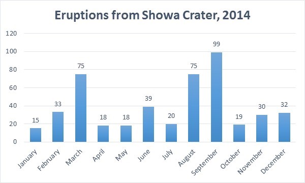 |
Figure 46. Number of eruptions during 2014 from Showa Crater on Sakurajima volcano at Aira caldera. Data from JMA Monthly reports. |
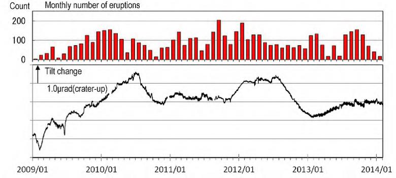 |
Figure 47. Number of monthly eruptions at Showa crater (red bars, top) on Sakurajima volcano at Aira caldera between 1 January 2009 and 31 January 2014. The lower graph represents the change in tilt observed with a water-tube tiltmeter at Arimura Station from January 2009 through January 2014 with tidal response eliminated. Inflation of the summit corresponds to positive tilts. Tilt values remained stable and changed little through 2014. Courtesy of JMA (Monthly Summary, January 2014). |
Small pyroclastic flows that reached 400-600 m SE or E of Showa Crater were reported three times in 2014, on 22 January, 12 February, and 4 July. The Minamidake summit crater was generally quiet. Only one very small eruption was reported from it on 19 January, and a few very small eruptions were reported there in May. Incandescence was visible from the Showa crater, where virtually all the activity was focused, during several nights almost every week throughout the year.
Significant ashfall was reported by JMA for the 22 January eruption; the Central Fire Department of Kagoshima Fire Prevention Bureau reported that lapilli with a diameter of up to 1 cm fell on an area of Arimuracho in Kagoshima City (about 3 km S of the Showa crater) and larger lapilli with a diameter of 3 cm fell on the Arimura Observation Point (also about 3 km S of the Showa crater).
Most of the explosions during the year sent rocks to within 800 m of the Showa crater. Rocks were ejected as far as 1,300 m from the Showa crater in seven explosive eruptions in January, 12 times in February, 22 times in August, and eight times in October. Larger eruptions sent rocks even farther to distances up to 1,800 m from the crater on 9 March, twice in September, on 28 November, and on 8 and 11 December.
Ash plumes rising to an altitude of 2-3 km were reported weekly by Tokyo VAAC throughout the year. Most of the plumes drifted SE or S, but occasionally were observed drifting NE and other directions as well. Every month (except April) plumes also rose to heights of 3.7-4.6 km, and twice (in May and June) the highest plumes to 5.5 km were reported. A web camera in Tarumizu (12 km SE of Sakurajima) captured a typical ash plume on 24 October that rose to 4.6 km and drifted E (figure 48).
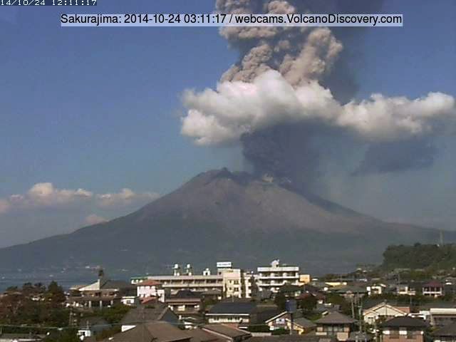 |
Figure 48. Image from an unspecified webcam in Tarumizu, 12 km SE of Aira's Sakurajima volcano, of an eruption at 1211 local time on 24 October 2014. The ash plume rose to 4.6 km altitude and drifted E. Image archived by and courtesy of Volcano Discovery. |
Geological Summary. The Aira caldera in the northern half of Kagoshima Bay contains the post-caldera Sakurajima volcano, one of Japan's most active. Eruption of the voluminous Ito pyroclastic flow accompanied formation of the 17 x 23 km caldera about 22,000 years ago. The smaller Wakamiko caldera was formed during the early Holocene in the NE corner of the caldera, along with several post-caldera cones. The construction of Sakurajima began about 13,000 years ago on the southern rim and built an island that was joined to the Osumi Peninsula during the major explosive and effusive eruption of 1914. Activity at the Kitadake summit cone ended about 4,850 years ago, after which eruptions took place at Minamidake. Frequent eruptions since the 8th century have deposited ash on the city of Kagoshima, located across Kagoshima Bay only 8 km from the summit. The largest recorded eruption took place during 1471-76.
Information Contacts: Japan Meteorological Agency (JMA), Otemachi, 1-3-4, Chiyoda-ku Tokyo 100-8122, Japan (URL: http://www.jma.go.jp/); Tokyo Volcanic Ash Advisory Center (VAAC), Tokyo, Japan (URL: http://ds.data.jma.go.jp/svd/vaac/data/); Volcano Discovery (URL: https://www.volcanodiscovery.com/).