Report on Santa Maria (Guatemala) — February 2016

Bulletin of the Global Volcanism Network, vol. 41, no. 2 (February 2016)
Managing Editor: Edward Venzke.
Edited by A. Elizabeth Crafford.
Santa Maria (Guatemala) Ash plumes drift 300 km W; lava flows continue down Caliente dome
Please cite this report as:
Global Volcanism Program, 2016. Report on Santa Maria (Guatemala) (Crafford, A.E., and Venzke, E., eds.). Bulletin of the Global Volcanism Network, 41:2. Smithsonian Institution. https://doi.org/10.5479/si.GVP.BGVN201602-342030
Santa Maria
Guatemala
14.757°N, 91.552°W; summit elev. 3745 m
All times are local (unless otherwise noted)
Since 1922, Guatemala's Santa Maria stratovolcano, located 18 km S of the city of Quetzaltenango, has been erupting. Continuous minor explosions, along with periodic lava extrusion, larger explosions, pyroclastic flows, and lahars, have characterized the activity for many years. Guatemala's INSIVUMEH (Instituto Nacional de Sismologia, Vulcanologia, Meterologia e Hidrologia) and the Washington VAAC (Volcanic Ash Advisory Center) provide regular updates on its activity.
The Santiaguito dome complex exhibited constant eruptive activity during July-December 2015. Numerous explosions were reported by INSIVUMEH and the Washington VAAC, with ash plumes rising as high as 7,000 m and drifting as far as 300 km; active lava flows continued down the east side of Caliente dome. In addition, several pyroclastic flows and lahars affected the area around the volcano. Near-constant minor ashfall affected communities within 20 km of the volcano.
Ash plumes, explosions and pyroclastic flows. The Palajunoj area, approximately 10-20 km SW of the Santiaguito dome complex, experienced ashfall events from the Caliente lava dome multiple times per week between July and December 2015. The farms, or 'fincas' of Palajunoj including El Monte Claro, Rosario, La Florida, and El Faro, and the village of San Marcos, were the most frequently affected by explosions. Typical ash plumes rose 500 to 800 m above the Caliente dome (to 3,000-3,300 m altitude) and deposited fine ash downwind, generally to the W and SW, up to 20 km.
Nearly every month during this time, one or more larger explosions were recorded to heights of 1,800 to 2,400 m above Caliente (4,300-4,900 m altitude). The volcanic ash from these emissions, as reported by the Washington VAAC, generally drifted tens of kilometers W and SW. Occasional larger explosive events affected an even wider area. On 24 August the Washington VAAC observed in satellite imagery the remnants of a plume that rose to 5,200 m (2,700 m above the dome) and drifted 300 km WSW.
On 29 August INSIVUMEH reported multiple loud explosions occurring four to six hours apart that included thick columns of ash and pyroclastic flows. Based on Observatorio del Volcán Santiaguito (OVSAN) observations, INSIVUMEH noted that on 29 September explosions from the lava-dome complex again generated multiple small pyroclastic flows. The largest of these traveled 4 km E down the Ángel and Nimá I drainages. Dense ash plumes drifted generally E, and caused ashfall in areas between Quetzaltenango (18 km WNW) and El Palmar (12 km S).
Large explosions reported by the Washington VAAC on 7 October and 30 November sent ash plumes to the SW at altitudes of 5,800 and 6,000 m, respectively. The largest group of explosions during this period, however, occurred in early December. Loud explosions and moderate pyroclastic flows on 1 December were noted by INSIVUMEH, and ashfall was reported to the WSW in San Marcos, La Florida and across the Palajunoj area. Washington VAAC observed the ash plume from these explosions at least as high as 7,000 m drifting SW for over 24 hours. Its farthest observed distance from the volcano was around 280 km WSW before dissipating on 2 December. Another series of large explosions with continued emissions took place on 5-6 December. INSIVUMEH reported fine ashfall at least 10 km from the dome in multiple directions, SW, S, SE, and E. Satellite images observed by the Washington VAAC showed an ash plume at 5,800 m altitude over 300 km to the W over the Gulf of Tehuantepec from these events. Another residual ash cloud at 5,200 m altitude was observed on 29 December 150 km SW from explosions that occurred on 28 December.
Lava flow. The lava flow that traveled down the E flank of the Caliente dome beginning in May 2014 and early 2015 (figure 40) continued to be active for the second half of 2015, but the activity was concentrated at the head of the flow near the dome. Block avalanches at the front of the new flows were reported every week. Additional lava was reported extruding from the Caliente dome on 1 September. Active lava flows with steam plumes 200-300 m high coming from the base of the dome were reported by INSIVUMEH on 19 September and again on 4 October. Incandescent avalanche blocks were observed often in November and December along the entire length of the E flank of the dome, suggesting that the upper part of the lava flow remained active. On 8 December, continuous lava flows down the outer SE edge of the dome from the crater to the base generated avalanche blocks and hot pyroclastic flows. Intermittent MODVOLC thermal alerts were also recorded during this time.
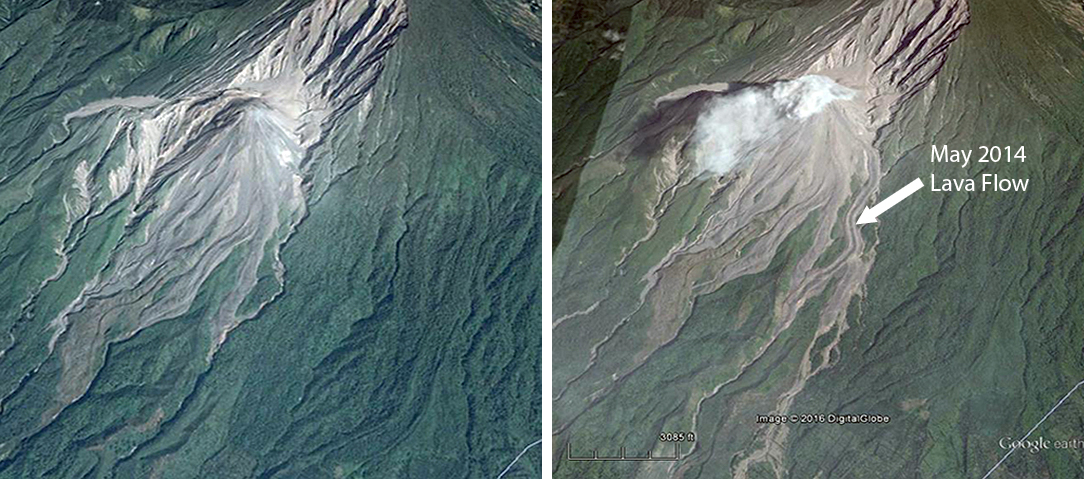 |
Figure 40. Google Earth images at different times show the growth of the lava flow that first emerged from Caliente dome in May 2014 at Santa Maria. The left image is dated April 2014 and the right image is dated March 2015. The new lava flow is visible travelling in a zig-zag pattern down the drainage to the SSW in the center of the image. It splits about half way down into two flows. North is to the top. Additional descriptions of the flow are given in BGVN 40:07. |
Lahars. On 8 September heavy rainfall triggered a hot lahar that descended the Nimá I river drainage on the S flank. The lahar carried tree trunks, branches, and 1-m-wide blocks, had a strong sulfur odor, and was 20 m wide and 1.5 m deep. Another smaller lahar descended the Nimá I river drainage on 11 September. INSIVUMEH reported that on 21 October heavy rainfall in the area triggered steaming hot lahars which again descended Nimá I and also the San Isidro drainage. Both lahars carried blocks as large as 1.5 m in diameter; the Nimá I deposit was 18 m wide and 1.5 m deep. Another heavy rainfall on 30 October area triggered cold lahars which descended the Cabello de Ángel (a tributary of Nimá I) and San Isidro (tributary of El Tambor) drainages. The lahar in San Isidro carried blocks that were 1-2 m in diameter.
Geological Summary. Symmetrical, forest-covered Santa María volcano is part of a chain of large stratovolcanoes that rise above the Pacific coastal plain of Guatemala. The sharp-topped, conical profile is cut on the SW flank by a 1.5-km-wide crater. The oval-shaped crater extends from just below the summit to the lower flank, and was formed during a catastrophic eruption in 1902. The renowned Plinian eruption of 1902 that devastated much of SW Guatemala followed a long repose period after construction of the large basaltic andesite stratovolcano. The massive dacitic Santiaguito lava-dome complex has been growing at the base of the 1902 crater since 1922. Compound dome growth at Santiaguito has occurred episodically from four vents, with activity progressing E towards the most recent, Caliente. Dome growth has been accompanied by almost continuous minor explosions, with periodic lava extrusion, larger explosions, pyroclastic flows, and lahars.
Information Contacts: Instituto Nacional de Sismologia, Vulcanologia, Meteorologia e Hydrologia (INSIVUMEH), Unit of Volcanology, Geologic Department of Investigation and Services, 7a Av. 14-57, Zona 13, Guatemala City, Guatemala (URL: http://www.insivumeh.gob.gt/inicio.html); Hawai'i Institute of Geophysics and Planetology (HIGP), MODVOLC Thermal Alerts System, School of Ocean and Earth Science and Technology (SOEST), Univ. of Hawai'i, 2525 Correa Road, Honolulu, HI 96822, USA (URL: http://modis.higp.hawaii.edu/); Washington Volcanic Ash Advisory Center (VAAC), Satellite Analysis Branch (SAB), NOAA/NESDIS E/SP23, NOAA Science Center Room 401, 5200 Auth Rd, Camp Springs, MD 20746, USA (URL: http://www.ospo.noaa.gov/Products/atmosphere/vaac/); Google Earth (URL: https://earth.google.com/).