Report on Soputan (Indonesia) — May 2016

Bulletin of the Global Volcanism Network, vol. 41, no. 5 (May 2016)
Managing Editor: Edward Venzke.
Edited by A. Elizabeth Crafford.
Soputan (Indonesia) High ash plume and lava in August-September 2012; multiple explosions, Strombolian activity, and lava flows in January-March 2015
Please cite this report as:
Global Volcanism Program, 2016. Report on Soputan (Indonesia) (Crafford, A.E., and Venzke, E., eds.). Bulletin of the Global Volcanism Network, 41:5. Smithsonian Institution. https://doi.org/10.5479/si.GVP.BGVN201605-266030
Soputan
Indonesia
1.112°N, 124.737°E; summit elev. 1785 m
All times are local (unless otherwise noted)
The Soputan stratovolcano on the northern tip of Indonesia's island of Sulawesi has had historically observed eruptions since the 18th century, possibly earlier. During this time the locus of eruptions has included both the summit crater and Aeseput, a prominent NE-flank vent that formed in 1906 and was the source of intermittent major lava flows until 1924. Since the 1980's ongoing lava-dome growth has produced ash explosions, lava flows, and Strombolian eruptions every few years. The last activity with explosions, ash plumes to 6 km altitude, and a pyroclastic flow occurred between July and August 2011 (BGVN 36:11).
Monitoring is the responsibility of PVMBG (Pusat Vulkanologi dan Mitigasi Bencana Geologi) also known as CVGHM (Center for Volcanology and Geological Hazard Mitigation), and for the aviation community is within the Darwin VAAC (Volcanic Ash Advisory Center) region. This report covers two eruptive episodes; renewed seismic activity in May 2012 preceded a short eruption between August and September 2012, and repeated explosions with lava flows and incandescent material were recorded between January and March 2015.
The first eruptive episode began with an explosion on 26 August 2012 and a 12.2 km altitude ash plume. MODVOLC thermal anomalies were recorded on 26 and 28 August, and a significant SO2 anomaly was visible on 27 August. A second explosion on 18 September generated a plume to 9.1 km altitude, lava flows, and incandescent material; MODVOLC thermal anomalies persisted from 18 through 22 September 2012. Soputan was then quiet until January 2015 when it erupted repeatedly between 6 January and 8 March 2015 with ash plumes, lava flows, and Strombolian activity. Substantial MODVOLC thermal anomalies were recorded on 21 January, 2-3 and 12-13 February, and 7-9 March 2015. Seismicity remained elevated through July 2015.
Activity during 2012. During 21-27 May 2012 observers in the village of Maliku (12 km NW of Soputan) noted white steam plumes rising 50-150 m above the crater. A sharp increase in the number of seismic events began on 25 May, prompting CVGHM to increase the Alert Level to 3 on 28 May 2012. The Alert Level was lowered back to 2 on 26 June. During most of August, observers noted white steam plumes rising 50-200 m above the summit crater. Each week during 1-25 August there was an increase in the number of deep volcanic earthquakes and earthquakes indicating avalanches.
On 26 August 2012 at 1936 local time, CVGHM reported visual observation of a large eruption with an ash plume rising to 1,000 m above the summit and drifting W; they raised the Alert Level to 3. It was accompanied by a burst of incandescent material that rose 50 m above the summit. Darwin VAAC issued an ash advisory shortly after the eruption indicating that a large plume was observed in satellite imagery rising to 12.2 km altitude and extending 150 km W. They noted that the eruption continued for four hours, and the plume was moving W at around 80 km/hour. After 24 hours, the plume was still visible in satellite imagery, at 6.1 km altitude and extending around 220 km SW. MODVOLC thermal anomalies were recorded on 26 and 28 August. NASA's Global SO2 monitoring program at Goddard Space Flight Center (GSFC) captured a significant SO2 plume from Soputan on 27 August from the OMI instrument on the Aura satellite (figure 9).
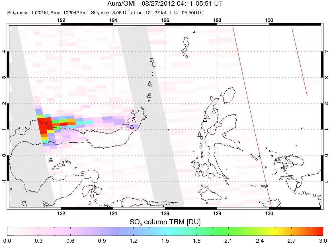 |
Figure 9. SO2 plume drifting W from Soputan on 27 August 2012, the day after an explosion that produced an ash plume to over 12 km altitude. Courtesy of NASA/GSFC. |
Another eruption during 18-19 September 2012 included an ash explosion, lava flows, and incandescent material, according to CVGHM. Based on information from the US Air Force Weather Agency (AFWA), the Darwin VAAC reported that an ash plume rose to an altitude of 9.1 km on 18 September. The ash cloud dispersed to the W between the summit elevation (1,785 m) and 3.7 km altitude, and to the NNE between 3.7 and 9.1 km altitude. Thermally anomalous pixels were recorded by the MODVOLC thermal alert system from 18 to 20 September, followed by a two-pixel anomaly on 22 September and a single-pixel anomaly on 27 September.
Activity during 2013 and 2014. Seismicity decreased in November 2012 to levels that allowed CVGHM to reduce the Alert Level from 3 to 2. From January through March 2013, the number of seismic events from avalanches increased significantly. On 19 April 2013 a sharp increase in the number of deep volcanic earthquake events caused CVGHM to raise the Alert Level again to 3. They also observed steam plumes rising to 400 m above the summit, higher than usual. No eruption occurred, and the steady decrease in seismicity in the following months caused CVGHM to lower the Alert Level back to 2 on 14 June 2013. On 1 May 2014 the Alert Level was again raised to 3 based on increases in seismicity, but it was lowered to 2 on 8 August 2014 after a steady decrease in seismicity and steam plumes rising less than 200 m from the summit. Thermally anomalous pixels detected by MODVOLC in October 2014 were located 5-10 km W of the summit and not likely related to volcanic activity. No explosions or other eruptive activity was reported by CVGHM during 2013 or 2014.
Activity during 2015. Observations in December 2014 indicated steam plumes rising less than 200 m above the summit. Low seismicity was detected until the third week of the month when there was a significant increase in the number of seismic events, prompting an increase in the Alert Level to 3 on 26 December 2014.
CVGHM reported to BNPB (Badan Nasional Penanggulangan Bencana, Indonesia's National Board for Disaster Management) that on 6 January 2015 an eruption occurred with an ash plume that rose 6.5 km above the summit and drifted ESE. A lava flow was also observed moving 2,000 m down the WSW flank of the volcano. A single MODVOLC thermal pixel was recorded on 7 January on the W flank. Based on ground reports from that same day, the Darwin VAAC noted a significant eruption that generated a plume to an altitude of 8.2 km, but ash was not confirmed in satellite images due to weather clouds in the area.
Seven more explosions were reported between 18 January and 7 March 2015. An explosion was witnessed on 18 January with a plume reported by CVGHM rising to 4 km and drifting SW. Strombolian explosions ejected incandescent material 500 m above the crater and down onto the flanks, and lava was seen flowing 500 m SW down the flanks. A single MODVOLC pixel was recorded on 18 January. On 20 January a plume rose to 3 km altitude and drifted 45 km SW as reported by Darwin VAAC. The explosion on 21 January generated a 3.7-km-altitude ash plume and was accompanied by a multi-pixel MODVOLC thermal anomaly.
A large 6.1-km-altitude plume on 1 February also coincided with a substantial MODVOLC thermal anomaly that persisted during 1-3 February. A smaller explosion on 8 February produced an ash plume that rose to 3 km and drifted 30 km SSE. CVGHM reported an eruption late on 10 February with an ash plume to 3.7 km that was observed on satellite imagery by Darwin VAAC early on 12 February. It also coincided with a significant multi-pixel MODVOLC thermal anomaly from 10-15 February.
Based on information from CVGHM and weather models, the Darwin VAAC reported that on 7 March an explosion generated large ash plumes that rose to an altitude of 9.1 km and drifted 260 km SE and SW. BNPB noted that pyroclastic flows traveled 2.5 km down the W flank and minor ashfall was reported in Silian Raya (10 km WSW), Touluaan (13 km SW), Tombatu (17 km SSW), and in the districts of Pasan (5 km SSW) and Ratahan (10 km SE). A substantial MODVOLC thermal anomaly first appeared on the N flanks on 7 March and lasted through 10 March (figure 10). The Alert Level remained at 3 (on a scale of 1-4). The next day, the VAAC noted that an ash plume rose to an altitude of 3.7 km and drifted almost 95 km SE before dissipating.
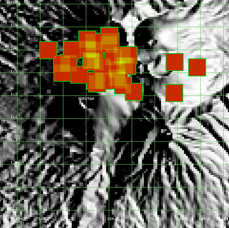 |
Figure 10. MODVOLC thermal anomalies at Soputan between 7 and 10 March 2015. Darwin VAAC reported a plume to 9.1 km on 7 March. CVGHM reported pyroclastic flows on the W flank and minor ashfall to the S and W on 7 March, followed by another ash emission on 8 March. The three separated pixels to the right (east) of Soputan may be agriculture related, but the others are likely related to the eruption. Green gridlines represent decimal latitude and longitude. Courtesy of MODVOLC. |
Seismicity continued to be variable through June 2015, with slowly declining frequency and magnitude of earthquakes (figure 11), and variable heights of steam plumes to 750 m. On 3 July 2015 CVGHM lowered the Alert Level to 2.
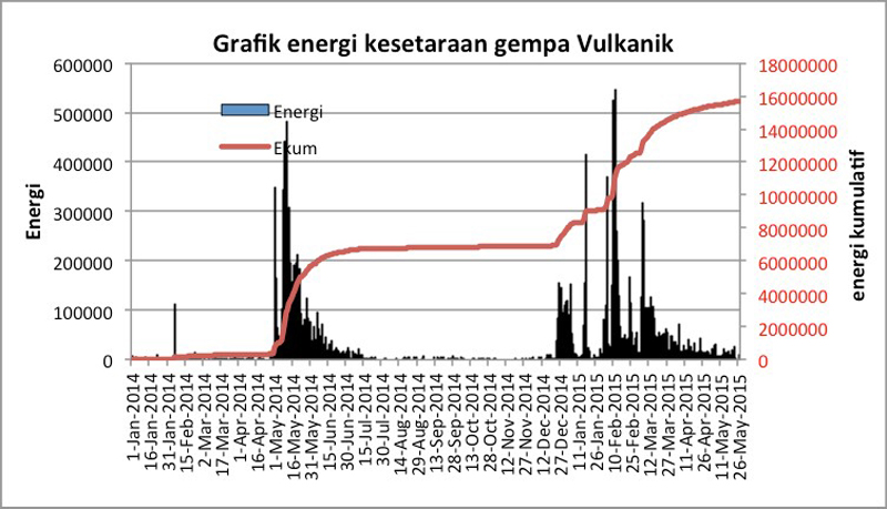 |
Figure 11. Volcanic earthquake energy equivalence chart for Soputan between 1 January 2014 and 26 May 2015. No ash explosions were reported between May and June 2014, during the first spike in energy release, but they were reported eight times between 6 January and 7 March 2015. Courtesy of CVGHM (Soputan Report, 29 May 2015). |
Geological Summary. The Soputan stratovolcano on the southern rim of the Quaternary Tondano caldera on the northern arm of Sulawesi Island is one of Sulawesi's most active volcanoes. The youthful, largely unvegetated volcano is the only active cone in the Sempu-Soputan volcanic complex, which includes the Soputan caldera, Rindengan, and Manimporok (3.5 km ESE). Kawah Masem maar was formed in the W part of the caldera and contains a crater lake; sulfur has been extracted from fumarolic areas in the maar since 1938. Recent eruptions have originated at both the summit crater and Aeseput, a prominent NE-flank vent that formed in 1906 and was the source of intermittent major lava flows until 1924.
Information Contacts: Pusat Vulkanologi dan Mitigasi Bencana Geologi (PVMBG, also known as Indonesian Center for Volcanology and Geological Hazard Mitigation, CVGHM), Jalan Diponegoro 57, Bandung 40122, Indonesia (URL: http://www.vsi.esdm.go.id/); Darwin Volcanic Ash Advisory Centre (VAAC), Bureau of Meteorology, Northern Territory Regional Office, PO Box 40050, Casuarina, NT 0811, Australia (URL: http://www.bom.gov.au/info/vaac/); NASA Goddard Space Flight Center (NASA/GSFC), Global Sulfur Dioxide Monitoring Page, Atmospheric Chemistry and Dynamics Laboratory, Goddard, Maryland, USA (URL: https://so2.gsfc.nasa.gov/); U.S. Air Force Weather Agency (AFWA)/XOGM, Offutt Air Force Base, NE 68113, USA; Hawai'i Institute of Geophysics and Planetology (HIGP), MODVOLC Thermal Alerts System, School of Ocean and Earth Science and Technology (SOEST), Univ. of Hawai'i, 2525 Correa Road, Honolulu, HI 96822, USA (URL: http://modis.higp.hawaii.edu/, http://modis.higp.hawaii.edu/cgi-bin/modisnew.cgi); Badan Nasional Penanggulangan Bencana (BNPB), National Disaster Management Agency, Graha BNPB - Jl. Scout Kav.38, East Jakarta 13120, Indonesia (URL: http://www.bnpb.go.id/).