Report on Sabancaya (Peru) — May 2016

Bulletin of the Global Volcanism Network, vol. 41, no. 5 (May 2016)
Managing Editor: Edward Venzke.
Edited by A. Elizabeth Crafford.
Sabancaya (Peru) Increased seismicity February 2013; explosive events in August 2014
Please cite this report as:
Global Volcanism Program, 2016. Report on Sabancaya (Peru) (Crafford, A.E., and Venzke, E., eds.). Bulletin of the Global Volcanism Network, 41:5. Smithsonian Institution. https://doi.org/10.5479/si.GVP.BGVN201605-354006
Sabancaya
Peru
15.787°S, 71.857°W; summit elev. 5960 m
All times are local (unless otherwise noted)
Although historical records of eruptive activity at Peru's Sabancaya volcano go back to 1750, there have only been a handful of eruptions documented since the 1980s; activity that began in 1986 was the first recorded in over 200 years. Weak solfataric activity from vents within and outside the 350-m-wide summit crater since then has created a persistent risk of ash plumes, Vulcanian explosions, and glacial melting causing mudflows. Reports of fresh ashfall on snow-covered slopes in 2003 (BGVN 29:01) indicated that some level of eruptive activity was continuing into the early 2000's. An increase in seismic and fumarolic activity in late 2012 and 2013 led to increased monitoring at the volcano, located 72 km NW of Arequipa. IGP-OVS (Instituto Geofisico del Peru, Observatoria Vulcanologico del Sur) and OVI-INGEMMET (Observatorio Volcanologico del INGEMMET, Instituto Geológical Minero y Metalúrgico) installed a number of seismic stations after significant seismic events in February 2013 (reported on in BGVN 38:02) caused damage to numerous homes in the area.
While the data reported by Peru's IGP-OVS and OVI-INGEMMET indicate ongoing seismic activity beginning in February 2013, and two phreatic-type explosions on 9 and 25 August 2014, no substantial eruption of ash was reported between February 2013 and February 2016. Numerous VAAC (Volcanic Ash Advisory Center) reports of ash were reported by pilots, but the Buenos Aires VAAC noted that no ash plume was visible either on satellite images or from the web camera located near the volcano. Occasional references to "possible light volcanic ash" are mentioned in some VAAC reports, but generally not corroborated with visual or satellite information. A few photographs from the area appear to show trace amounts of fine ash or particulates from magmatic gases in the snow around the crater, but such deposits were not confirmed by fieldwork. Throughout the period, Sabancaya emitted significant water vapor plumes occasionally as high as 3,000 m, and SO2-rich magmatic gases that were blue in color and possibly contained trace amounts of ash.
Activity during 2013 and 2014. After a decade of quiet, a significant increase in fumarolic emissions was observed in late 2012 (BGVN 38:02). Throughout 2013 earthquakes were concentrated in areas NE, N and NW of the crater up to 25 km away; much of this seismicity was later interpreted by IGP-OVS to be related to regional tectonism and not to volcanic activity. An increase in SO2 emissions, seen as bluish gas emitting from the fumaroles, was observed in March 2013, but a field visit in May noted no fresh lava or ash in the area.
White, gray, and bluish SO2-rich fumarolic emissions increased in June 2014. VT (volcano-tectonic) earthquakes were recorded within 1.7 km of the crater in early July; IGP-OVS seismologists identified hybrid-type seismic events that they associated with the rise of magmatic material near the crater in early July. By mid-July, VT earthquakes were averaging over 200 per day, and the foci were located 12 km NNE of the crater. During late July, seismic events decreased, and the foci moved to 8 km N of the crater. Persistent off-white and bluish fumaroles rose 500-600 m above the crater during July 2014.
Fumarolic emissions intensified markedly on 5 August 2014, rising to 3 km above the crater; whitish water vapor, bluish magmatic gases, and gray emissions were observed, suggesting a "possible release of minor volcanic ash", as reported by IGP-OVS. The VT seismic events also began to increase in magnitude, ranging between 2.5 and 4.6 ML, including two located very close to the crater, between 4 and 14 km deep. Both LP and Hybrid seismic events, increased to hundreds of events per day in the early days of August. At 0429 local time on 9 August 2014 a large explosion was recorded; it was not observed due to darkness and cloud cover. After the explosions, VT events dropped back to tens per day, and emissions rose to between 500 and 1,000 m above the crater. Many of the earthquakes were located within 1.5 km of the crater at depths between 4 and 14 km. On 25 August beginning at 2039 local time four consecutive explosions lasting a total of 82 seconds were recorded (figure 14). Again, due to darkness, there was no visual confirmation of the explosion.
 |
Figure 14. Seismograph from 25 August 2014 at SAB seismic station, located 3 km from the top of Sabancaya. Four explosive events occurred in the crater area at 2039 local time, followed by numerous small earthquakes. The energy calculated by IGP-OVS for this sequence of events was 1,151 MJ, with a total duration of 82 seconds. Courtesy of IGP-OVS (2014 Annual Report, Sabancaya). |
In the days between the 9 and 25 August explosions, observed emissions from the fumaroles were water vapor and bluish magmatic gases rising to heights between 500 and 1,500 m above the crater (figure 15).
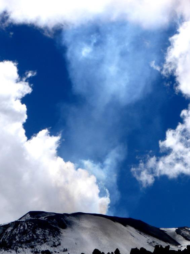 |
Figure 15. Emissions from Sabancaya on 13 August 2014. White vapor plumes and bluish SO2-rich magmatic gases are emitting from the crater. Courtesy of IGP-OVS (2014 Annual report, Sabancaya). |
Water vapor and magmatic gas plume heights in September 2014 rose between 500 and 2,000 m above the crater. OVI-INGEMMET daily reports noted grayish plumes containing "possible ash" on 26 and 29 September 2014.
In October 2014, fumarolic emission heights were below 1 km above the crater; they were generally white steam plumes but also showed significant bluish SO2 content. Constant emissions of water vapor and SO2 to heights of 1,400 m above the floor of the crater continued into November along with intermittent seismic activity at constant levels since August. Seismicity increased slightly in early December and fumaroles of water vapor and SO2 were observed rising to heights between 500 and 1,600 m above the crater floor. Seismic signals characteristic of a mudflow were recorded in mid-December 2014 in the ravine between Sabancaya and Ampato, the large volcano immediately SW.
Buenos Aires VAAC reports in 2014 were all ambiguous as to the presence of ash from Sabancaya. A "faint ash cloud" was detected in visible imagery on 14 July 2014. Numerous pilot reports of ash between August and December were not verified by satellite imagery under clear skies, and the webcam usually revealed water vapor emissions or cloud cover at the summit at the time of most of the reports. VAAC reports that do mention "possible minor volcanic ash" were given on 16 September, 23 October, 10 November, and 27 December 2014.
Activity during 2015 and early 2016. A similar level of activity continued during 2015. Neither OVI-INGEMMET nor IGP-OVA reported explosions with ash emissions during the year. Constant emissions of steam and bluish magmatic gases were observed from the fumaroles within the crater. Plumes of water vapor and magmatic gases rose to 1 km above the crater in January and to 1.2 km in February. From March through May seismic activity remained steady and fumarolic plumes were consistently below 1 km above the crater.
Seismicity increased during June 2015. Fumarolic plume heights also increased to 2.4 km above the crater, and bluish SO2-rich gases were frequently observed. During July, some seismic events were located within 3 km of the crater, and fumarolic plumes rose to 2 km. Volcanologists from OVI-INGEMMET visited on 10 July 2015 and observed trace amounts of ashfall or particulates from SO2 emissions in the vicinity of the crater (figure 16). IGP-OVS scientists who visited in late July to make temperature measurements observed constant water vapor and magmatic gas emissions. The temperature at the side of the dome was measured at 81°C, and the hottest points at the bottom of the crater were 391° and 280°C.
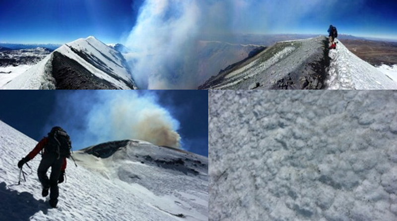 |
Figure 16. Crater inspection of Sabancaya on 10 July 2015 where trace amounts of ash or particulates from SO2 emissions were observed. Courtesy of OVI-INGEMMET. |
During late August 2015 and the first week of September seismicity increased significantly, and was located within 6 km of the crater at depths between 6 and 9 km. Fumarolic emissions ranged between 600 and 1,600 m above the crater. Seismicity was low during October. An IGP-OVS visit on 1 October obtained temperature data similar to that collected in late July. The expedition reported the absence of recently deposited solid material in the vicinity of the crater, and also observed the constant emission of steam and magmatic gases (figure 17).
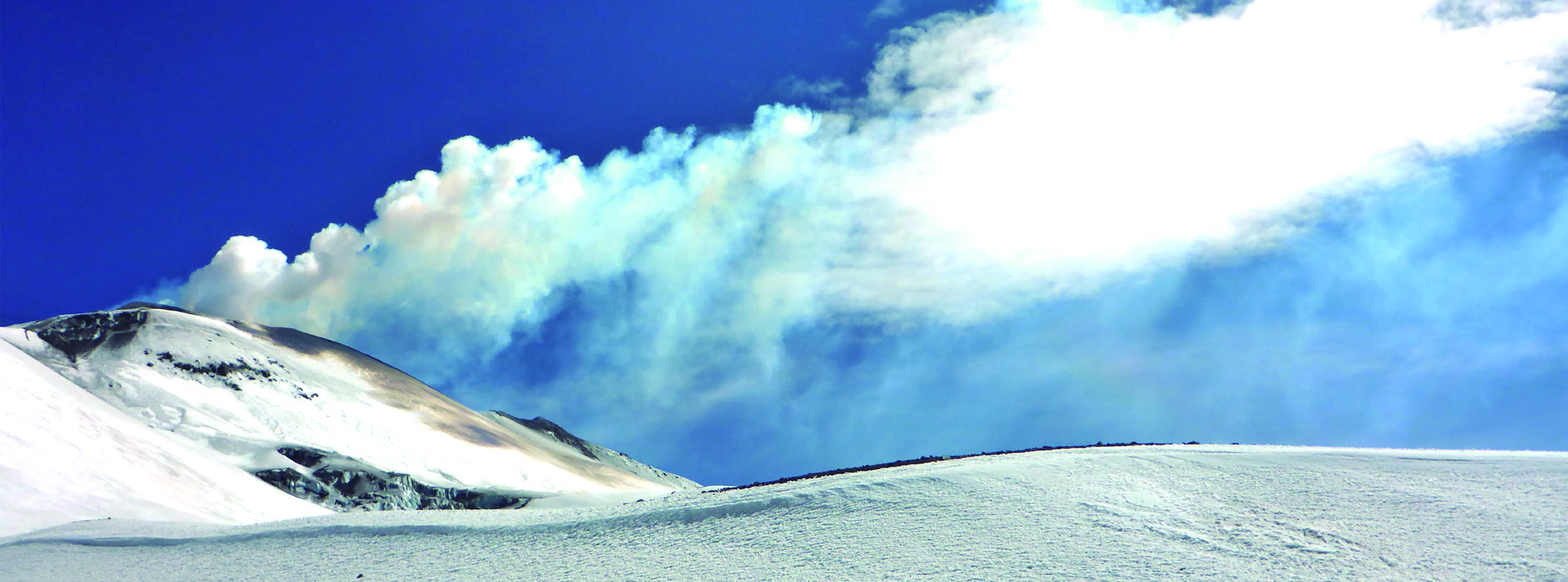 |
Figure 17. Emissions of white steam and bluish magmatic gases from Sabancaya in the early hours of 1 October 2015. Courtesy of IGP-OVA (2015 Annual report, Sabancaya). |
VT seismicity remained low in November 2015, but an increase in the second week in December included two events (4.0 and 3.6) located within 2 km of the volcano. Constant emissions of water vapor and magmatic gases rising to 1,100 m were observed.
Buenos Aires VAAC reports for 2015 were again ambiguous about the presence of ash. Many reports note that pilot observations of ash clouds were not corroborated by satellite or webcam images. However, on several occasions, the VAAC reports indicated that the webcam showed continuous emission of steam, gases, and "possible light volcanic ash" (8 March, 19 May, 15 and 21 June, 18 and 21 July, 26 August, 10 October, 6 November and 12 December).
Sabancaya maintained a similar level of seismic and fumarolic unrest through February 2016 that was monitored and reported by both OVI-INGEMMET and IGP-OVS. OVI-INGEMMET reported plume heights of water vapor in early January as high as 2,000 m above the crater, gradually decreasing to below 1,000 m in early February. The intermittent presence of magmatic gases was also noted during this time.
While there have not been substantial ash emissions since renewed seismic activity began in 2013, there have been measurable SO2 emissions observed by IGP-OVS and recorded by NASA's OMI instrument (figure 18). Emissions of SO2 recorded on 27 December 2014 (0.937 kT), 3 April 2015 (0.750 kt), 28 November 2015 (0.773 kt), 25 February 2016 (0.365 kt) appear most likely to have originated at Sabancaya.
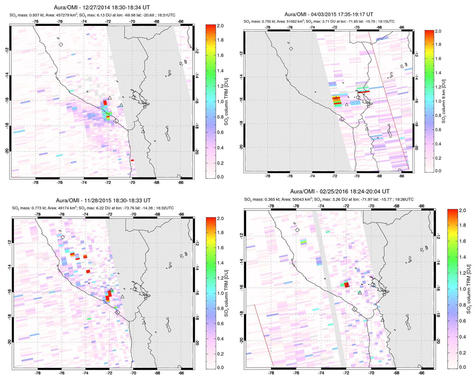 |
Figure 18. Four different images from the OMI instrument satellite data from NASA's Goddard Space Flight Center showing SO2 anomalies possibly attributable to Sabancaya (upper left triangle). The image dates are 27 December 2014 (top left), 3 April 2015 (top right), 28 November 2015 (bottom left), and 25 February 2016 (bottom right). Courtesy of NASA Goddard Space Flight Center. |
Geological Summary. Sabancaya, located in the saddle NE of Ampato and SE of Hualca Hualca volcanoes, is the youngest of these volcanic centers and the only one to have erupted in historical time. The oldest of the three, Nevado Hualca Hualca, is of probable late-Pliocene to early Pleistocene age. The name Sabancaya (meaning "tongue of fire" in the Quechua language) first appeared in records in 1595 CE, suggesting activity prior to that date. Holocene activity has consisted of Plinian eruptions followed by emission of voluminous andesitic and dacitic lava flows, which form an extensive apron around the volcano on all sides but the south. Records of observed eruptions date back to 1750 CE.
Information Contacts: Instituto Geofisico del Peru, Observatoria Vulcanologico del Sur (IGP-OVS), Arequipa Regional Office, Urb La Marina B-19, Cayma, Arequipa, Peru (URL: http://ovs.igp.gob.pe/); Observatorio Volcanologico del INGEMMET, (Instituto Geológical Minero y Metalúrgico) (OVI-INGEMMET), Barrio Magisterial Nro. 2 B-16 Umacollo - Yanahuara Arequipa (URL: http://ovi.ingemmet.gob.pe); Buenos Aires Volcanic Ash Advisory Center (VAAC), Servicio Meteorológico Nacional-Fuerza Aérea Argentina, 25 de mayo 658, Buenos Aires, Argentina (URL: http://www.smn.gov.ar/vaac/buenosaires/inicio.php?lang=es); NASA Goddard Space Flight Center, Global Sulfur Dioxide Monitoring Page, Atmospheric Chemistry and Dynamics Laboratory (URL: https://so2.gsfc.nasa.gov/).