Report on San Cristobal (Nicaragua) — July 2016

Bulletin of the Global Volcanism Network, vol. 41, no. 7 (July 2016)
Managing Editor: Edward Venzke.
Edited by A. Elizabeth Crafford.
San Cristobal (Nicaragua) Ash explosion on 22 April 2016
Please cite this report as:
Global Volcanism Program, 2016. Report on San Cristobal (Nicaragua) (Crafford, A.E., and Venzke, E., eds.). Bulletin of the Global Volcanism Network, 41:7. Smithsonian Institution. https://doi.org/10.5479/si.GVP.BGVN201607-344020
San Cristobal
Nicaragua
12.702°N, 87.004°W; summit elev. 1745 m
All times are local (unless otherwise noted)
After ash explosions on 6 and 12 June 2015 (BGVN 40:09), San Cristóbal remained quiet for the rest of the year. Monthly reports from INETER (Instituto Nicaragüense de Estudios Territoriales) described degassing from the fumarolic vents which had consistent temperature variations in the 60° to 80°C range as regularly measured since December 2014. Landslides on the S and SE flanks of the inner crater were observed in November 2015. The number of seismic events continued a downward trend from 510 in September 2015 to 147 events in December. Over 90% of the events were related to degassing, with the remainder being VT (volcano-tectonic), LP (long-period), or tremor events. RSAM values generally remained in the background range of 25-30 units.
Seismicity remained low in January 2016 with only 130 seismic events recorded and RSAM values between 30 and 40 units. Observations of the gas plume indicated that it generally drifted WSW or NW, rising only a small distance above the summit.
At 1020 on 22 April 2016 both INETER and SINAPRED (Sistema Nacional para la Prevencion, Mitigacion y Atencion de Desastres) reported an explosion which sent an ash-and-gas plume 2 km above the crater that drifted SW. The seismic network recorded 10 additional explosions by 1200. Ashfall was reported in local areas, including Las Brisas (10 km S), San José (8 km SSE), Santa Narcisa, Pellizco Central (12 km SSE), Los Ébanos, Los Lirios (18 km WSW), Santa Cruz (35 km SE), Las Grietas (14 km E), El Liberal, and San Lucas (13 km E). The INETER report noted that this event was larger than the explosive activity in June 2015.
Continued temperature observations of the fumaroles from the SE part of the crater in June 2016 showed little variation from average values over the last two years (figure 32).
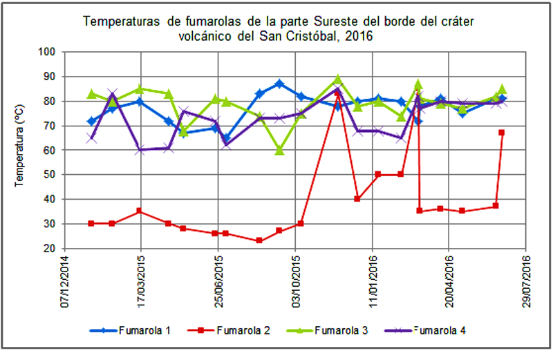 |
Figure 32. Fluctuations of fumarole temperatures from the SE part of the crater at San Cristobal from December 2014 through June 2016 show consistent variation and range of values. Courtesy of INETER (Monthly Report, June 2016). |
INETER periodically measures SO2 emissions from San Cristobal. Measurements in June 2016 from two separate transects returned average values of 558 and 477 tons per day on 10 and 24 June, respectively. The transects covered regions 10-15 km from the volcano on the west side. The values were very similar to those collected in October 2015.
Geological Summary. The San Cristóbal volcanic complex, consisting of five principal volcanic edifices, forms the NW end of the Marrabios Range. The symmetrical 1745-m-high youngest cone, named San Cristóbal (also known as El Viejo), is Nicaragua's highest volcano and is capped by a 500 x 600 m wide crater. El Chonco, with several flank lava domes, is located 4 km W of San Cristóbal; it and the eroded Moyotepe volcano, 4 km NE of San Cristóbal, are of Pleistocene age. Volcán Casita, containing an elongated summit crater, lies immediately east of San Cristóbal and was the site of a catastrophic landslide and lahar in 1998. The Plio-Pleistocene La Pelona caldera is located at the eastern end of the complex. Historical eruptions from San Cristóbal, consisting of small-to-moderate explosive activity, have been reported since the 16th century. Some other 16th-century eruptions attributed to Casita volcano are uncertain and may pertain to other Marrabios Range volcanoes.
Information Contacts: Instituto Nicaragüense de Estudios Territoriales (INETER), Apartado Postal 2110, Managua, Nicaragua (URL: http://www.ineter.gob.ni/); Sistema nacional para la Prevencion, Mitigacion y Atencion de Desastres (SINAPRED), Edificio SINAPRED, Rotonda Comandante Hugo Chávez 50 metros al Norte, frente a la Avenida Bolívar, Managua, Nicaragua (URL: http://www.sinapred.gob.ni/)